[ Home ]
The tallgrass prairie includes range vegetation that can be visualized as consisting of two major forms: 1) once-vast grasslands in the continental interior of North America and 2) zones of grasslands and marshes along the shores of North America extending from the Atlantic Coast through the Gulf of Mexico. Climate of the former is continental; that of the latter is maritime. Species composition (including dominants) of plants and animals is similar (sometimes nearly the same) on both of these two basic forms or expressions of tallgrass range. Differences in species in the pre-Columbian ecosystems of these forms was probably not great as there were similar species (= similar ecological niches) or ecological equivalents among range types in them. For example, the dominant climax gallinaceous birds of the interior tallgrass bluestem prairies (eg. Flint Hills and Osage Questas of Kansas and Oklahoma), Gulf of Mexico coastal cordgrass prairies and marshes, and small patches of northern cordgrass prairies along the Atlanic Coast were one subspecies of the grouse known as greater prairie chicken (Tympanuchus cupido pinnatus), Attwater prairie chicken (T. cupido attwateri), and heath hen (T. cupido cupido), respectively. Of course the heath hen is extinct, the Attwater in dire trouble, and the greater is declining, but such similarity in taxa of the major grassland bird of each of these recognized generic grasslands illustrated the ecological relatedness of these major forms of tallgrass grasslands and various range cover types therein.
For pedagogic purposes and convenience (ease of viewing examples) the tallgrass prairie sub-formation (or sub-biome) of North Amereican grasslands was divided into two separate chapters designated as interior tallgrass prairie and coastal tallgrass prairie. There are marshes (herbaceous plant communities usually with the soil surface covered by standing water most of the year or growing season) in (or affilitated with) both of these major forms of tallgrass prairie. Marshes have often interpreded as different from grasslands, perhaps even as separate biomes. Natural distinction between prairie (dominant plants are species of grasses hence grassland) and marsh (dominant plants include species of grasslike plants such as sedges, bulrushes or tules, rushes, cattails, etc. as well as grasses). Designations and differences are often unclear or even arbitrary as, for example, distinction between wet prairie and marsh. The same dominant and associate species of plants are sometimes common to adjacent grassland and marsh. This condition is more common in coastal prairies and marshes than in interior prairies and associated wetlands. Generally marshes are more common and prominent plant communities in coastal than in interior grassland vegetation. Such was reflected in names of these two major forms of tallgrass prairie.
It could be argued that the term prairie could or should encompass both grassland and marsh thereby uniting these two general units of range vegetation. Perhaps prairie could be interpreted so as to include both grassland and marsh. Such a union is not possible given the traditional designation of vegetational or land resource area 2 in Texas as Coastal Prairies and Marshes. The long-standing convention of this "purple-pedigreed" title was retained in the current publication. Rangemen simply have to learn to live with a certain amount of ambiguity.
In the Gulf Prairies and Marshes there are range plant and animal communities that are not strictly speaking dominated by tallgrass species. These include such habitats as seashores and salt flats. Such range vegetation or plant and animal communities are, however, part of the Gulf Prairies and Marshes landscape or greater ecosystem (when seen from pserpective of Landscape Ecology or Ecosystem Ecology). In context of a publication devoted to range types these units of range vegetation were distinctive and different enough from described rangeland cover types (Shiflet, 1994)-- and obviously essential or integral to development and functioning of recognized range types-- that such vegetation was included herein.
As far as marshes are concerned these vary along gradients of salinity which to some extent reflects distance inland from the Gulf of Mexico. Stutzenbaker (1999, ps. 16-17) recognized four types of coastal marsh in Texas based on salinity levels: 1) freshwater marsh (0 to 0.5 parts per thousand salinty), 2) intermediate marsh (0.5 to 3.5 parts per thousand salinity), 3) brackish marsh (3.5 to 10 parts per thousand salinity), and 4) saline (10 parts per thousand or greater). In addition to actual marshes there are zones of range vegetation in hypersaline habitats along margins of Laguna Madre which is regarded as Earth's largest hypersaline lagoon. Hypersalinity has often been regarded as havein 40 to p0 parts per thousand salinity).
Probably the best authority and most nearly completely coverage of coastal tallgrass prairie is that of Smeins et al.(in Coupland, 1992, ps. 269-290).
1. Gulf or Coastal Prairies and Marshes vegetational area of Texas- a landscape mosaic of many ecosystems from estuaries to tallgrass prairie to patches or corridors of the "running" form of live oak (Quercus virginiana) and red bay (Persea borbonia). San Antonio Bay on Aransas National Wildlife Refuge, winter home of the whooping crane (Crus americana).Coming inland from the bay the zones of various communities (many of them consociations or populations) are:
Refugio County, Texas. Late heimal- prevernal aspect, February. SRM 726 (Cordgrass) of several forms and variants. Beardgrass Series (Gulf Coastal Grassland) of Brown et al. (1998). Western Gulf Coastal Plains- Mid-Coast Barrier Islands and Coastal Marshes Ecoregion, 34h (Griffith et al., 2004).
2. Texas Coastal Praries and Marshes- Zones of vegetation from San Antonio Bay. Coming from the bay inland these are:
the short form of smooth cordgrass (tan-colored zone on far side of the bay),
the green zone is saltmarsh bulrush (Scirpus maritimus) and black needlerush (Juncus roemerianus),
the zone of low-stature vegetation inland from the green zone is the grass community dominated by seashore saltgrass, shoregrass, sea blite, and Virginia glasswort or saltwort,
the zone of tufted plants is a tidal flat dominated by the cespitose marshhay cordgrass with sea ox-eye plus some scattered Gulf cordgrass, and
the inland-most or woody vegetation (foreground) is live oak-red bay (Persea borbonia)-yaupon forest.
The two zones of 1) smooth coregrass and 2) saltmarsh bulrush-black needlerush comprise saltmarsh whereas the 3) salt-shoregrass community and the 4) marshhay cordgrass make up the tidal flat. Vegetation of these herbaceous zones were shown in preceding slides. Calhoun County, Texas. Hibernal aspect, February. No single FRES or K-unit could describe this. Texas Coastal Prairies and Marshes Vegetation (= Land Resource) Area. Beardgrass Series of Brown et al. (1998). Western Gulf Coastal Plains- Mid-Coast Barrier Islands and Coastal Marshes Ecoregion, 34h (Griffith et al., 2004).
3. Texas Coastal Bend Prairie- Arch-typical Texas coastal prairie that is basically a consocition of seacoast little bluestem (Andropogon littoralis= Schizachyrium scoparium var. littoralis) with silver bluestem as the major associate and smaller proportions of such tallgrass species as crinkleawn (Trachypogon secundus), Paspalum species, Gulf cordgrass, Indiangrass, and Pan American balsamscale (Elyonurus tripsacoides). Almost no forbs; no woody plants.
Aransas National Wildlife Reguge, Refugio County, Texas. October. FRES No.39 (Prairie Ecosystem), K-69 (Bluestem-Sacahuiste [Gulf Cordgrass] Prairie), SRM 711 (Bluestem-Gulf Cordgrass Prairie). Gulf Coastal Grassland Biotic Community 143.3, Beardgrass Series 143.31 of Brown et al.(1998, p.40). Western Gulf Coastal Plains- Mid-Coast Barrier Islands and Coastal Marshes Ecoregion, 34h (Griffith et al., 2004).
4. Upland (versus bottomland or beach) coastal prairie- This scene is a transect shot extending from a few feet above sea level down literally into the Gulf waters of San Antonio Bay. Several range sites occur along the landscape seen here which extends from coastal prairie to the salt water marsh of smooth cordgrass (spartina alterniflora) out in the bay. Species visible in the prairie of the foreground include seacoast bluestem (the most common species), big bluestem, silver bluestem, Indiangrass, bottomland switchgrass (ie. a Four Horsemen prairie the same as the Flint Hills of Kansas, Osage Hills of Oklahoma, Sand Hills of Nebraska, or Blackland Prairie of Texas), Pan American balsamscale, common reed (Phragimites communis), bushy bluestem (Andropogon glomeratus) with Turk's cap and Gulf Coast coneflower as major forbs.
Aransas National Wildlife Reguge, Refugio County, Texas. October.
5. Pan American balsamscale- This member of the Andropogoneae tribe provides forage of only fair to, rarely, good nutritive value but it is a common associate on coastal prairies. It is a distinctive grass but a species lesser known to most rangemen. It was included here to illustrate the vast diversity of species on North American grasslands.
Aransas National Wildlife Reguge, Refugio County, Texas. October.
6. Inflorescence of Pan American balsamscale. Aransas National Wildlife Reguge, Refugio County, Texas. October.
7. Composite shot of both the coastal prairie and Gulf salt marsh- The foreground is a tallgrass prairie with bottomland switchgrass conspicuous at far right along with bushy bluestem, seacoast bluestem, the conspicuous Gulf Coast Mexican hat, and common reed (visible as the tallest three or four rank shoots at front edge of water). The background beginning at back edge of the stream is a smooth cordgrass salt marsh. Two distinct range cover types (and two distinct Kuchler units and FRES Ecosystems) are clearly separated by the water line: brackish or salt water from San Antonio Bay reaches up to the back side of the stream (which is mostly fresh water) and supports smooth cordgrass which is Gulf Coast salt marsh: FRES No. 41 (Wet Grasslands), K- 70 (Southern Cordgrass Prairie), SRM 806 (Gulf Coast Salt Marsh). In front of the fresh water stream which serves as a barrier against intrusion of Gulf salt water from the bay is coastal tallgrass prairie: FRES No. 39 (Prairie Ecosystem), either K- 66 (Bluestem Prairie) or K-69 (Bluestem-Sacahuiste [Gulf Cordgrass] prairie and thus either SRM 710 (Bluestem Prairie) or 711 (Bluestem-Gulf Cordgrass Prairie). Gulf Coastal Grassland Biotic Community 143.3, Beardgrass Series 143.31 of Brown et al.(1998, p.40) was as close as there was in that system. Western Gulf Coastal Plains- Mid-Coast Barrier Islands and Coastal Marshes Ecosystem, 34h (Griffith et al., 2004). There is very little of either marshhay or Gulf cordgrass so it is basically tallgrass prairie as explained in the previous landscape scene. Aransas National Wildlife Refuge, Refugio County, Texas. October.
8. Gulf Coast saltwater cordgrass marsh- This unique grassland community is a consociation of smooth cordgrass (Spartina alterniflora) that extends the entire length of the Gulf Coast clear up along the Atlantic Seaboard, often in patches or of intermittent distribution, to the salt marshes of New England extending to Nova Scotia. These regularly flooded tidal or Gulf marshes "&hellp;are almost exclusively Spartina alterniflora marshes&hellp;" and are "&hellp; almost a natural monoculture of Spartina alterniflora&hellp;" (Teal, 1986, p.1). It forms the Great Barnstable Marsh at Cape Cod, Massachusetts and the smooth cordgrass marshes at Cape Hatteras National Seashore, South Carolina. Furthermore the S. alterniflora marshes have a worldwide distribution occurring in Argentina and western Europe, including the British Isles (Teal, 1986, p.3). It has been widely studied and shown that there are two varieties of S. alterniflora: tall form and a short form of smooth cordgrass with the tall being on tidal creeks with fresh water and the short variety on sites or local areas subject to flooding with salt water. Some workers reported an intermediate form between fresh (or slightly brackish) and salt water (Haines and Dunn in Chabot and Mooney, 1985, ps. 323-341).
This plant community is, of course, a major part of the estuaries all along the coast. In fact, smooth cordgrass is often the major producer in these estuaries (Odum, 1971, p. 357). It was while working with these tidal marshes in Georgia that Eugene Odum discovered that the salt marsh-estuary ecosystem (the tidal or coastal wetlands= coastal tidelands) is probably the most productive ecosystem on Earth. Work like this and that by Teal (and the very popular book by Teal and Teal [1969]) as well as publicity by prominent conservationists like Rachel Carson spawned a nationwide effort to save what remained of United States’ ocean marshes and estuaries. The story of this largely successful, remarkable conservation program was published by (Siry, 1984).
Of more direct historical interest to range students is the fact that the smooth cordgrass salt marshes formed part of the vast coastal and bay range that was the cradle of the range cattle industry in Texas and Louisiana. The famous Longhorns in this region were appropriately dubbed by Texas cowmen as "coasters" and "sea lions".
Aransas National Wildlife Refuge, Refugio County, Texas. October. FRES No. 41 (Wet Grasslands Ecosystem), but Kuchler did not map the smooth cordgrass tidal flats (tidal, coastal, or sea marshes). Specifically the smooth cordgrass "monoculture" is one component or varient of SRM 806 (Gulf Coast Salt Marsh). Beardgrass Series of Brown et al. (1998). Western Gulf Coastal Plains- Mid-Coast Barrier Islands and Coastal Marshes Ecoregion, 34h (Griffith et al., 2004).
9. Inside a cordgrass (gulf and marshhay) tidal flat- A woody component of the composite Baccharis halimifolia and the borage, seaside heliotrope (Heliotropium curassavicum ), surrounded by red bay-live oak shrub (or actually trees) to constitute a "forest" of sorts.
Aransas Refuge, Refugio County, Texas. FRES No. 41 (Wet Grasslands Ecosystem). K-70 (Southern Cordgrass Prairie). SRM 726 (Cordgrass) or, partially , SRM 719 (Mesquite-Live Oak- Seacoast Bluestem). Gulf Coastal Grassland Biotic Community 143.3, Beardgrass Series 143.31 of Brown et al.(1998, p.40) was closest in that classification system. Western Gulf Coastal Plains- Mid-Coast Barrier Islands and Coastal Marshes Ecoregion, 34h (Griffith et al., 2004).
10. Aransas Tidal flat range community- Marshhay cordgrass (green tufts on right margin), seashore or coastal saltgrass (adjacent and immediately left of cordgrass), shoregrass (Monanthochloe littoalis) left and adjacent to saltgrass, sea ox-eye (Borrichia frutescens) is the pea-green forb, common brown forb producing most cover is perennial sea blite (Suaeda conferta), and scattered yellow forbs are Virginia glasswort or saltwort (Salicornia virginica).
Aransas National Wildlife Refuge, Refugio County, Texas. October.
11. Species of Aransas tidal flats- Annual saltwort (S. bigelovii) in shoregrass. Aransas National Wildlife Refuge, Refugio County, Texas. October.
12. Sward of seashore saltgrass and shoregrass.Aransas National Wildlife Refuge, Refugio County, Texas. October.
13. Seashore paspalum (Paspalum vaginatum)- This species sends stolons up to edge of (frequently extending into) Gulf water. It is one of the most salt water-tolerant grasses in the world. Aransas National Wildlife Refuge, Refugio County, Texas. October.
14. Archtypical scene of coastal prairie- Swale-and-ridge gulf grassland comprised of the Four Horsemen tallgrasses and surrounded by live oak mottes plus laurel oak (Quercus hemisphaerica), red bay, and yaupon (Ilex vomitoria). Associate grassland species include marshhay cordgrass and bushy bluestem (Andropogon glomeratus). Much of the little buestem is the sea coast form treated by some as a variety of little bluestem (Schizachyrium scoparium var. littoralis) but as a distinct species (Andropogon littoralis) by Hitchcock and Chase (1950).
Aransas National Refuge, Refugio County Texas. Prevernal aspect, February. FRES No. 41 (Wet Grasslands Ecosystem) and FRES No. 16 (Oak-Gum-Cypress Ecosystem). K-70 (Southern Cordgrass Prairie) surrounded by K-81 (Live Oak-Sea Oats). SRM 726 (Cordgrass) and SRM 719 (Mesquite-Live Oak-Seacoast Bluestem). Gulf Coastal Grassland Biotic Community 143.3, Beardgrass Series 143.31 of Brown et al.(1998, p.40). Western Gulf Coastal Plains- Mid-Coast Barrier Islands and Coastal Marshes Ecoregion, 34h (Griffith et al., 2004).
15. Closer view of the fauna of the Scirpus colony- A female American alligator (Alligator mississippiensis) is the representative of the largest reptile of the Atlantic coastal prairies and marshes. This 'gator was reportedly 13 feet long.
Aransas National Refuge, Refugio County Texas. Prevernal aspect, February. FRES No. 41 (Wet Grasslands Ecosystem), K- 42 (Tule Marshes), SRM 807 (Gulf Coast Fresh Marsh). Western Gulf Coastal Plains- Mid-Coast Barrier Islands and Coastal Marshes Ecoregion, 34h (Griffith et al., 2004).


16. Mixed mixture- Landscape-scale view of a brackish marsh western Gulf Coast Brackish marshes are an "in between" form of herbaceous wetland--a marsh--that develop between salt marshes and fresh marshes in habitats where there is abundant inflow of freshwater (typically from rivers) mixing with saline water from an ocean (or, in this case, Gulf Coast) so as to dilute incoming seawater (as from Gulf Coast tides) to intermediate levels of salinity. The term brackish refers to this intermediate category between fresh water and salt water. Brackish environments such as brackish marshes typically develop above (upward, inland, or upstream) from saline environments, such as those of salt marshes, yet downstream or closer to saline bodies of water than freshwater habitats (eg. freshwater marshes). Some authors, including Bernier et al. (2011), recognized a category of intermediate marsh between freshwater marsh and brackish marsh.
There are often very pronounced zones and patches of marsh plant species over remarkably short distances (small spatial scale) that correspond to differences in soil salinity, relief (topography), and distances from high tide or storm-water inundation. This mosaic pattern of vegetation was shown to good advantage in these two views of the Gulf Coast landscape.
Major range plant species included marsh hay cordgrass (Spartina patens), the overwhelming dominant, along with the low form of smooth cordgrass (S. alternifolia); and big cordgrass (S. cynosuroides); American bulrush, known also as chairmaker's bulrush and Olney's three-square bulrush (Scirpus americanus= S pungens= S. olneyi), and the rhizomatous shrub known variously as bushy seaside tansy, sea oxeye, sea oxeye daisy, and sea-marigold (Borrichla frutescens). There was a local consociation (small, restricted microsite) of big cordgrass in foreground of the second slide.
The brackish marsh vegetation seen here and in the rest of the photographs of this mosaic of range plant communities had developed in the western chenier plain of the West Gulf Coast in southwestern Louisiana.
Sabine National Wildlife Refuge, Cameron Parish Louisiana. Mid-July; early estival aspect. FRES No. 41 (Wet Grassland Ecosystem). K-70 (Southern Cordgrass Prairie). SRM 726 (Cordgrass) and/or SRM 806 (Gulf Coast Salt Marsh): range vegetation shown here could fit equally well either or both of these rangeland cover types. (Perhaps it was appropriate that there should be conflicting or overlapping claims on Gulf rangeland cover types consistent with the precident from history when France and Spain each claimed the land of Louisiana.) Gulf Coastal Maritime Marshland 243.3, Saltgrass Series 243.11 of Brown et al. (1998, p. 45). Western Gulf Coastal Plains- Texas-Louisiana Coastal Marshes Ecoregion, 34g (Daigle et al., 2006).

17. Big boys and some others- On a brackish marsh on the western chenier plain (versus the delta plain) in southwestern coastal Louisiana there was this local consociation of big cordgrass (Spartina cynosuroides) in foreground except left one-fourth and all the way to distant background in upper rioght corner. Herbaceous cover in extreme left foreground and oblique-shaped (left to right) background was mostly marshhay cordgrass and American (= Olney's= chair-maker's) bulrush.
As implied by the common name of big cordgrass, S. cynosuroides is the largest or, at least, the tallest, of the cordgrass (Spartina) species along the Western Gulf Coast of North America.
Sabine National Wildlife Refuge, Cameron Parish Louisiana. Mid-July; early estival aspect. FRES No. 41 (Wet Grassland Ecosystem). K-70 (Southern Cordgrass Prairie). SRM 726 (Cordgrass) and/or SRM 806 (Gulf Coast Salt Marsh): range vegetation shown here could fit equally well either or both of these rangeland cover types. (Perhaps it was appropriate that there should be conflicting or overlapping claims on Gulf rangeland cover types consistent with the precident from history when France and Spain each claimed the land of Louisiana.) Gulf Coastal Maritime Marshland 243.3, Saltgrass Series 243.11 of Brown et al. (1998, p. 45). Western Gulf Coastal Plains- Texas-Louisiana Coastal Marshes Ecoregion, 34g (Daigle et al., 2006).


18. Sorta salty- Landscape-scale views of the vegetational mosaic of brackish marsh in the North American Western Gulf Coast, western chenier plain (versus the delta plain), in extreme southwestern Louisiana. The predominant or most abundant (cover, density, biomass) species in these two views was marshhay cordgrass (patches of lighter green) followed closely by the low- or short-form (one of more of the lower-growing ecotypes) of smooth cordgrass (darker-green color in these slides). Other halophytic range plant species in this brachish habitat included the prominent shrubby composite most commonly known (at least in these parts) as sea myrtle (Baccharis halimifolia) and the rank-growing, herbaceous chenopod known variously as wormseed, Jesuit's tea, or Mexican-tea (Chenopodium ambrisiodes), left and right, respectively, in left to center foreground of first slide. Common reed (Phragmites communis= P. australis), a locally dominant grass species, was represented by a single prominent shoot in right foreground of first slide.
Smooth cordgrass as a local stand (small-scale consociation) dominated the foreground in the second slide with a marshhay cordgrass (lighter green color in both of these two slides) consociation in midground and another smooth cordgrass consociation in background. The line of taller vegetation in background of second slide was mostly sea myrtle and wormseed with some sea oxeye. (This latter shrub/grass line was presented in the immediately succeeding slide/caption set.)
Thtwo views of halophytic marsh vegetation was an example of the zonation (most likely due to salinity levels in the soil) of different species along the Gulf Coast. This zonation sometimes occurs at larger spatial scale in going from salt through brackish to freshwater marshes. In these two views shrubs such as sea myrtle and the composite forb, wormseed grew on land of slightly higher elevation than that of the coregrasses, especially smooth cordgrass.
Sabine National Wildlife Refuge, Cameron Parish Louisiana. Mid-July; early estival aspect. FRES No. 41 (Wet Grassland Ecosystem). K-70 (Southern Cordgrass Prairie). SRM 726 (Cordgrass) and/or SRM 806 (Gulf Coast Salt Marsh): range vegetation shown here could fit equally well either or both of these rangeland cover types. (Perhaps it was appropriate that there should be conflicting or overlapping claims on Gulf rangeland cover types consistent with the precident from history when France and Spain each claimed the land of Louisiana.) Gulf Coastal Maritime Marshland 243.3, Saltgrass Series 243.11 of Brown et al. (1998, p. 45). Western Gulf Coastal Plains- Texas-Louisiana Coastal Marshes Ecoregion, 34g (Daigle et al., 2006).


19. Little higher, little less salt- This series of three progressively closer camera-distance slides made a "double-nested photo-plot" (a nested plot inside a nested plot inside an ovrall plot) of a local halophytic range plant community that developed on a brackish marsh on the western chenier plain in the Gulf Coast of southwestern Louisiana. This local vegetational community was Mother Nature's own "fencerow", a long, narrow zone of plant life that was comprised of the three principal shrub species, sea myrtle, sea oxeye, and bigleaf marsh-elder (Iva frutescens); the semi-woody vine or viney sub-shrub called variously cow-itch, ivy treebine, possom ivy, or marine-ivy, (Cissa incisa); the forb species, wormwood or Mexican-tea, and two principal grass species, smooth cordgrass as dominant herbaceous species and knotroot bristlegrass (Setaria geniculata), the associate or second-most sbundant grass.
The first of these three slides was the general or overall "photo-plot". The second slide was a "sub-photo-plot" nested within the first view or slide while the third slide was a still-yet closer view of herbaceous vegetation "nested" within the second slide which was the "nested photo-plot" or "sub photo-plot". In other words, the third slide was a "sub-sub-photo-plot" or a "sub-nested photo-plot". The first photograph presented the local range plant community described in the preceding paragraph. The second photograph presented the immediate edge where the three shrub species and cow itch or marine-ivy as a woody "line" of plant life abutted the herbaceous "line" dominated by the low form of smooth cordgrass with knotroot bristlegrass as the associate species. The third photograph showed these two grasses enjoying each other's company.
Sabine National Wildlife Refuge, Cameron Parish Louisiana. Mid-July; early estival aspect. FRES No. 41 (Wet Grassland Ecosystem). K-70 (Southern Cordgrass Prairie). SRM 726 (Cordgrass) and/or SRM 806 (Gulf Coast Salt Marsh): range vegetation shown here could fit equally well either or both of these rangeland cover types. (Perhaps it was appropriate that there should be conflicting or overlapping claims on Gulf rangeland cover types consistent with the precident from history when France and Spain each claimed the land of Louisiana.) Gulf Coastal Maritime Marshland 243.3, Saltgrass Series 243.11 of Brown et al. (1998, p. 45). Western Gulf Coastal Plains- Texas-Louisiana Coastal Marshes Ecoregion, 34g (Daigle et al., 2006).


20. Salty hay- Floral units of marshhay or saltmarsh cordgrass on a specimen growing on a brackish marsh in the western Gulf Coast (the western chenier plain versus the delta plain) in southwest Louisiana. The anthers of these spikelets were prominent.
A very good practical description of saltmarsh cordgrass along with its grazing management was that in the terse guide compiled by Leithead et al. (1971, p. 167).
Marshhay or saltmarsh cordgrass has a remarkable biological range that extends from the north Atlantic Coast around the Gulf Coast and up the Pacific Coast up to British Columbia.
Sabine National Wildlife Refuge, Cameron Parish Louisiana. Mid-July; full-bloom (anthesis) phenological stage.


21. Short on height, long on salt- Two individuals ofthe short form of smooth cordgrass on a brackish marsh in the western Gulf Coast (on the western chenier plain versus the delta plain) in southwestern Louisiana. Smooth cordgrass grows on both organic and mineral soils along the Gulf Coast and up the Atlantic Coast all the way to the province of Quebec.
Sabine National Wildlife Refuge, Cameron Parish Louisiana. Mid-July; full-bloom phenological stage.


22. Short and salty- A robust specimen of the short form (a low-growing ecotype) of smooth cordgrass (first slide) and its contracted panicle (second slide) on a brackish marsh of the western chenier plain portion of the western Gulf Coast in southwest Louisiana. One of the best descriptions of smooth cordgrass as a range plant along with its management on coasstal ranges was that in the packed-with-information guide of Leithead et al. (197, p. 161).
The spikelets in this panicle were at peak anthesis.
Sabine National Wildlife Refuge, Cameron Parish Louisiana. Mid-July; full-bloom phenological stage.
Habitat note: smooth cordgrass and marshhay cordgrass often grow in association ((Leithead et al. (1971, p. 167)


23. Marshy chenopod- Sexual shoots of wormseed, Jesuit's tea, or Mexican-tea (Chenopodium ambrisiodes) growing on a brackish marsh in the North American Western Gulf Coast. This was the western chenier plain (versus the delta plain) in extreme southwestern Louisiana. Regardless of its presence on this somewhat saline edaphic environment, wormseed is also adapted to nonsaline habitats as it ranges in Texas, for example, from the coastal marshes across to sandier soils of the West Crosss Timbers and Edwards Plateau (Diggs et al., 1999, ps. 535-536). Salt marshes are, however, a favorite habitat of/for wormseed (Correll and Johnston, 1979, p. 533).
Wornseed is also quite versatile in its life cycle pattern being either an annual or perennial. As to be expected with such versatility in resource allocation, wormseed grows on both pristine vegetation as featured here and on disturbed locations such as old fields and, even, local, abandoned urban areas. There were actually parts of shoots of two plants in the first slide and only part of the shoots of one plant in the second slide. Both plants had perennial shoots that appeared to be suffrutescent or suffruticose: these "tops" seemed to have survived more than one year or one warm-growing season. This could be expected in warm, nearly frostless southern Louisiana. Nonetheless, wormseed is a forb and not a shrub (Correll and Johnston, 1979, p. 533).
These plants of wormseed were growing beside ecotypes of the short form of smooth cordgrass and the herbaceous vine known as cow itch (Cissus incisa).
Sabine National Wildlife Refuge, Cameron Parish Louisiana. Mid-July; full-bloom phenological stage.

24. Wormseed fruit- Fruit borne on the former inflorescence of wormseed growing on a brackish mrsh in the western chenier plains of southwestern Louisiana. This sexual shoot was one of those produced by one of the plants introduced in the immediately preceding two slides. The basis of the specific epithet, ambrisiodes, should be obvious to rangemen familar with the ragweeds (Ambrosia species) given the close resemblance (at least superficially) of this chenopod species, especially its sexual organs, to the ambrosoid composites.
Furthermore, this chenopod has a strong aromatic odor similar to that of the large composite group of Artemisia species. In fact, wormseed contains at least one terpene and has served as an antihelminthic (dewormer); however, overdosing and death has been documented in humans and livestock (Kingsbury, 1964). In fact one taxonomic variety of C. ambrosioides is anthelminticum (Correll and Johnsoon, 1979, p. 533). Wormseed was long used for its medicinal properties by American Indians and, later, frontiersmen (eg. as a treatment for malaria). More recently, wormseed found use as a seasoning in Mexican cookery, hence one common name of "Mexican tea" (Diggs et al., 1999, ps. 535-536).
Sabine National Wildlife Refuge, Cameron Parish Louisiana. Mid-July; full-bloom phenological stage.


25. Cows itchy on the marsh?- Cow itch, treebine, or marine-ivy (Cissus incisa) growing on a brackish marsh in the in the western chenier plains of southwestern Louisiana. This specimen of cow itch was growing in a large population of the short form of smooth cordgrass (essentially a consociation of S. alternifolia). That smooth cordgrass community was presented above. The main forb (which was quite limited) was the chenopod called wormseed or Jesuit's tea (see immediately above), but cow itch usually grows primarily as an herbaceous vine and less frequently as a semi-woody vine, at least in its basal shoot, (Vines, 1960, p. 709) such that this species could also be regarded as a forb, specifically as a suffrutescent ("slightly shrubby or woody at the base" [Vines, 1960, p. 1032]) range plant.
Cow itch is in the grape family (Vitaceae) along with the closely related coon-grape or 'possum-grape (Ampelopsis cordata) and pepper-vine (A. arborea). as well as the widespread Virginia creeper (Parthenocissus quinquefolia). By the way, 'possum-grape is a frequently used common name for C. incisa (Fernald, 1950, p. 994; Correll and Johnston, 1979, p. 1022; Great Plains Flora Association, 1986, p. 557). (This is a case where common names are quite confusing.) Good descriptions of this semi-woody vine or "sub-liana" (if the author could coin a temporary term for descriptive purposes) were provided by Vines (1960, p.709), Correll and Johnston (1979, ps. 1022-1023), and Kurz (2004, 324-325), all of whom regarded this trailing perennial of the grape family as a woody vine.
Marine-ivy is probably the most descriptive common name for C. incisa on brackish marshes of the Gulf of Mexico. This semi-woody range plant is also also found in the Rio Grande or Tamulipian Plain of south Texas south into Mexico and northward through the Texas and Oklahoma Panhandles north to Kansas and Missouri and southeast to Florida (Fernald, 1950, p. 995; Vines, 1960, p. 709; Great Plains Flora Association, 1986, p. 558; Kurz, 2004, p. 324).
The inflorescence of marine-ivy was described by Fernald (1950, p. 994) as "an umbelliforn cyme".
Sabine National Wildlife Refuge, Cameron Parish Louisiana. Mid-July; full-bloom phenological stage.


26. Brackish drainage- A brackish marsh that had developed along a man-made drainage ditch to control (at least attempt to control) salinity of an otherwise natural brackish marsh in the western chenier plain of southwest Louisiana. Marsh vegetation presented here consisted of small colonies or populations of American (=chairmaker's= Olney's) bulrush, common reed, seashore dropseed (Sporobolus virginicus), sea oxeye (known also as sea oxeye daisy and sea-marigold), and American glasswort or perennial saltwort (Salicornia virginica).
Drainage ditches like this serve to regulate salinity from sea water from the Gulf of Mexico and help to preserve freshwater marshes or intermediate marshes versus saltwater marshes. Such water management structures reduce saltwater intrusion while maintaining adequate flow of fresh water.
Sabine National Wildlife Refuge, Cameron Parish Louisiana. Mid-July; early estival aspect. FRES No. 41 (Wet Grassland Ecosystem). K-70 (Southern Cordgrass Prairie). SRM 726 (Cordgrass) and/or SRM 806 (Gulf Coast Salt Marsh): range vegetation shown here could fit equally well either or both of these rangeland cover types. (Perhaps it was appropriate that there should be conflicting or overlapping claims on Gulf rangeland cover types consistent with the precident from history when France and Spain each claimed the land of Louisiana.) Gulf Coastal Maritime Marshland 243.3, Saltgrass Series 243.11 of Brown et al. (1998, p. 45). Western Gulf Coastal Plains- Texas-Louisiana Coastal Marshes Ecoregion, 34g (Daigle et al., 2006).


27. Mesic prairie meets marsh or, perhaps, wet prairie- Climax vegetation in a transition zone or ecotone between a mesic (average soil moisture content as compared to wet or hydric at one end and xeric or "droughty" on the other end of the soil moisture scale) prairie (more-or-less typical tallgrass prairie) and a wet prairie of grasses or, perhaps, a marsh of grasses and grasslike plants in the western chenier plain (versus the delta plain) in the Gulf Coast of southwestern Louisiana. Major range plant species in this wetland plant community were switchgrass (Panicum virgatum), common reed, American or chairmaker's bulrush, seashore dropseed, and sea myrtle (=sea oxeye= sea oxeye daisy).
There were two herbaceous layers to this range vegetation, but the lower layer consisting of species like seashore dropseed was more interrupted or spordic than that of the uninterrupted or continuous taller layer made up of overshadowing tallgrass species and the larger grasslike plants.
Water was standing on the land surface (ie. indunated or covered soil surface) of this herbaceous wetland in early summer.
Sabine National Wildlife Refuge, Cameron Parish Louisiana. Mid-July; early estival aspect. FRES No. 41 (Wet Grassland Ecosystem). K-70 (Southern Cordgrass Prairie). SRM 726 (Cordgrass) and/or SRM 806 (Gulf Coast Salt Marsh): range vegetation shown here could fit equally well either or both of these rangeland cover types. (Perhaps it was appropriate that there should be conflicting or overlapping claims on Gulf rangeland cover types consistent with the precident from history when France and Spain each claimed the land of Louisiana.) Gulf Coastal Maritime Marshland 243.3, Saltgrass Series 243.11 of Brown et al. (1998, p. 45). Western Gulf Coastal Plains- Texas-Louisiana Coastal Marshes Ecoregion, 34g (Daigle et al., 2006).


28. Widespread and locally common- A local stand (an ecological consociation) of common reed on a brackish marsh in the western Gulf Coast on the western chenier plain (versus the delta plain) of southwest Louisiana. Other marsh plant species in this common reed consociation included sea oxeye daisy or sea-marigold and seacoast dropseed. This latter loer-growing grass species formed an interrupted or sporadic layer beneath the upper layer made up by common reed. This lower layer of marsh vegetation was visible in the second or vertical slide.
Sabine National Wildlife Refuge, Cameron Parish Louisiana. Mid-July; early estival aspect. FRES No. 41 (Wet Grassland Ecosystem). K-70 (Southern Cordgrass Prairie). SRM 726 (Cordgrass) and/or SRM 806 (Gulf Coast Salt Marsh): range vegetation shown here could fit equally well either or both of these rangeland cover types. (Perhaps it was appropriate that there should be conflicting or overlapping claims on Gulf rangeland cover types consistent with the precident from history when France and Spain each claimed the land of Louisiana.) Gulf Coastal Maritime Marshland 243.3, Saltgrass Series 243.11 of Brown et al. (1998, p. 45). Western Gulf Coastal Plains- Texas-Louisiana Coastal Marshes Ecoregion, 34g (Daigle et al., 2006).


29. In between the in between- Climax vegetation of an intermediate marsh (a marsh with soil salinity between that of freshwater marsh and brackish marsh) on the western Gulf Coast (the western chenier plain versus the delta plain) in southwest Louisiana. Marsh plant species (in more or less relative proportion of cover and biomass) were chairmaker's or American bulrush, marshhay cordgrass, seashore dropseed, sea oxeye daisy or sea-marigold, and American glasswort or perennial saltwort.
Sabine National Wildlife Refuge, Cameron Parish Louisiana. Mid-July; early estival aspect. FRES No. 41 (Wet Grassland Ecosystem). K-70 (Southern Cordgrass Prairie). SRM 726 (Cordgrass) and/or SRM 806 (Gulf Coast Salt Marsh): range vegetation shown here could fit equally well either or both of these rangeland cover types. (Perhaps it was appropriate that there should be conflicting or overlapping claims on Gulf rangeland cover types consistent with the precident from history when France and Spain each claimed the land of Louisiana.) Gulf Coastal Maritime Marshland 243.3, Saltgrass Series 243.11 of Brown et al. (1998, p. 45). Western Gulf Coastal Plains- Texas-Louisiana Coastal Marshes Ecoregion, 34g (Daigle et al., 2006).

30. Intermediate players close up- Herbage of vegetation of an intermediate marsh (one with soil salinity between that of freshwater marsh and brackish marsh in the western Gulf Coast (in the western chenier plain versus the delta plain) of southwest Louisiana. Shoots shown here included American or chairmaker's rush, seashore dropseed, and sea oxeye or sea-marigold, a dominant shrub. This latter was represented only by its leaves rather than a portion of woody shoot.
Sabine National Wildlife Refuge, Cameron Parish Louisiana. Mid-July; early estival aspect. FRES No. 41 (Wet Grassland Ecosystem). K-70 (Southern Cordgrass Prairie). SRM 726 (Cordgrass) and/or SRM 806 (Gulf Coast Salt Marsh): range vegetation shown here could fit equally well either or both of these rangeland cover types. (Perhaps it was appropriate that there should be conflicting or overlapping claims on Gulf rangeland cover types consistent with the precident from history when France and Spain each claimed the land of Louisiana.) Gulf Coastal Maritime Marshland 243.3, Saltgrass Series 243.11 of Brown et al. (1998, p. 45). Western Gulf Coastal Plains- Texas-Louisiana Coastal Marshes Ecoregion, 34g (Daigle et al., 2006).


31. Here's to salt in your eye- Sexual shoot (first or vertical slide) and capitulum or head (second or horizontal slide) of sea oxeye, sea oxeye daisy, sea-marigold (Borrichla frutescens) growing in association with American or chairmaker's bulrush, seashore dropseed, and marshhay cordgrass on an intermediate marsh in the western Gulf Coast (in the western chenier plain versus the delta plain) of southwest Louisiana.
Sea oxeye is in the huge sunflower tribe (Heliantheae) of the sunflower, daisy, or aster family (Compositae).
Sabine National Wildlife Refuge, Cameron Parish Louisiana. Mid-July; full-bloom stage of phenology.

32. Another brackish view- Climax vegetation of a brackish marsh composed of 1) a taller layer made up almost exclusively of the grasslike plant known variously as seacoast bulrush, alkali bulrush, or three-cornered bulush (Scirpus robustus) and a lower layer dominated (and almost exclusively so) by seashore dropseed. Actually, these two species formed local populations that were consociations, and these consociations were almost completely separate from each other. The two species did not co-minger to any biologically significant degree. Instead, they grew as two distinct and segregated populations, the two populations of which together comprised this two-layer marsh plant community.
Sabine National Wildlife Refuge, Cameron Parish Louisiana. Mid-July; early estival aspect. FRES No. 41 (Wet Grassland Ecosystem). K-70 (Southern Cordgrass Prairie). SRM 726 (Cordgrass) and/or SRM 806 (Gulf Coast Salt Marsh): range vegetation shown here could fit equally well either or both of these rangeland cover types. (Perhaps it was appropriate that there should be conflicting or overlapping claims on Gulf rangeland cover types consistent with the precident from history when France and Spain each claimed the land of Louisiana.) Gulf Coastal Maritime Marshland 243.3, Saltgrass Series 243.11 of Brown et al. (1998, p. 45). Western Gulf Coastal Plains- Texas-Louisiana Coastal Marshes Ecoregion, 34g (Daigle et al., 2006).
Insidious loss: a sad commentary of the coastal wetlands of North America (much of Earth's wetland area in general for that matter) had been the physical and chemical loss (ie. erosional disppearance, pollution including salinization, etc.) of much wetland area as a result of a number of factors, including saltwater intrusion and accelerated soil erosion). For example there has been (and continutes to be) loss of herbaceous wetland on the Sabine National Wildlife Refuge on which the above photographs were taken. One particularly factual report of this loss was that compiled and analyzed by Bernier et al. (2011).
Caution to would-be marsh visitors- Some of the craziest, most reckless, and generally discourteous drivers this widely traveled range pilgrim ever encountered were in southern Louisiana. This was especially so regarding a general lack of respect for pedestrians. This was just the opposite of frontier range custom whereby it was universally recognized that mounted (mule- or horseback) denizens had the advantage over groundlings and therefore equistrians yielded to those who were at a disadvantage by nature of being unmounted or afoot. It was the opposite for beasts of burden pulling heavy loads.
Gentlefolk do not take unfair advantage of their fellow sojourners or violate basic rules of decency on the highways of life. Forget about the heritage of respect (not to mention for range custom) if you are in southern Louisiana. In fact, all too often just plain decency was woefully lacking from many residents in southern Louisiana. Its people were the most unfriendly and most disrespectful of walkers (visitors in general) that the author of Range Tpes of North America ever encountered.
In you are in southern Louisiana be alert. Motorists will run over you. Sadly, southern hospitality seemed as eroded as the wetlands.
Secondly, be advised that the Sabine National Wildlife Refuge is very inaccessible. Compared to public roads that run through the McFadden and Anahuac National Wildlife Refuges and along large ranch properties such as the Humphrey Ranch, across the state line in Texas, the main Louisiana road (State Highway 27) through the Sabine was narrow with no shoulders but plenty of signs telling motorists that parking was prohibited. Furthrmore, roads inside the Sabine National Wildlife Wildlife Refuge were closed with locked gates (at least when this author visited in mid-July). As far as accessibility was concerned this refuge was at the opposite end of the spectrum from readily accessible National Wildlife Refuges such as the National Bison Range and National Elk Refuge.
The McFadden and Anahuac National Wildlife Refuges in adjoining Orange and Jeffrson Counties, Texas are much more accessible, and range vegetation is the same kind of Gulf Coast marsh. Visiting the Sabine National Wildlife Refuge was not very rewarding. This author paid a big preminum to bring ya'll these few photographs. Advice to potential marsh visitors: go across the state line to Texas (hard-learnt lesson from an Okie).

33. A salty situation- Gulf Coast salt marsh that was a consociation of seashore saltgrass (Distichlis spicata= D. spicata var. spicata). This saltgrass zone of coastal salt marsh was near mouth of Sabine River as it slowly drains into the Gulf of Mexico. Range vegetation in background varied considerably and included marsh communities dominated alternatively by tule or bulrush (Scirpus spp.), common cattail (Typha latifolia), common reed (Phragmites communis= P. australis) and even sedges (Carex spp.) as well as prairie plant communities dominated by various cordgrasses (Spartina spp.), bluestems (Andropogon spp.), and panicgrass (Panicum sp.). These other range cover types or subtypes were covered below.
Jefferson County, Texas. February, late hibernal aspect. FRES No. 41 (Wet Grassland Ecosystem). K-70 (Southern Cordgrass Prairie). SRM 726 (Cordgrass) and/or SRM 806 (Gulf Coast Salt Marsh): range vegetation shown here could fit equally well either or both of these rangeland cover types. (Perhaps it was appropriate that there should be conflicting or overlapping claims on Gulf rangeland cover types consistent with the precident from history when France and Spain each claimed the land of Louisiana.) Gulf Coastal Maritime Marshland 243.3, Saltgrass Series 243.11 of Brown et al. (1998, p. 45). Western Gulf Coastal Plains- Texas-Louisiana Coastal Marshes Ecoregion, 34g (Griffith et al., 2004).

34. Salty sward- Close-in view of sward of the vast stand of seashore saltgrass presented in the preceding slide and in part of the salt marsh vegetation shown in the next two slides.
Jefferson County, Texas. February, late hibernal aspect.


35. Two narrow zones- Zonal range vegetation at fine scale had developed on this salt to brackish marsh on the Gulf Coast of Texas. On the right (to right of ponded water) of both of these "photo-plots" a seashore saltgrass consociation made up a sharply distinct vegetational zone of coastal marsh whereas a diverse mixture of bulrush, common cattail, and cordgrass formed another zonal range community in the left of the "plots" (beginning directly in and behind ponded water).
These various range plant communities, as denoted by dominant species, were treated below.
Jefferson County, Texas. February, late hibernal aspect. FRES No. 41 (Wet Grassland Ecosystem). K-70 (Southern Cordgrass Prairie). SRM 726 (Cordgrass) and/or SRM 806 (Gulf Coast Salt Marsh): range vegetation shown here could fit equally well either or both of these rangeland cover types. (Perhaps it was appropriate that there should be conflicting or overlapping claims on Gulf rangeland cover types consistent with the precident from history when France and Spain each claimed the land of Louisiana.) Gulf Coastal Maritime Marshland 243.3, Saltgrass Series 243.11 of Brown et al. (1998, p. 45). Also of Brown (1998, p. 45): Gulf Coastal Maritime Marshland 243.3, there should be a Bulrush Series and a Cattail Series consistent with those of Northeastern Interior Marshland for Bulrush and Cattail and of Southeastern Interior Marshland for Cattail. Western Gulf Coastal Plains- Texas-Louisiana Coastal Marshes Ecoregion, 34g (Griffith et al., 2004).
Note on diversity and species richness of range vegetation presented from ranges in Jefferson County, Texas: Diggs et al. (2006) listed and mapped for the relatively small Jefferson County, Texas (in which many of the ranges shown here were found) the following number of species of grasslike plants: 32 Carex, 19 Cyperus, 13 Eleocharis, 8 beak-rush or beak sedge (Rhynchospora), six Scirpus, five fimbry (Fimbristylis), and four Schoenoplectus. Undoubtedly, many and probably most of these species grew on the Gulf Coast marsh and prairie ranges presented herein.


36. Botanic "polyplot" on the Gulf Coast- This ungrazed Gulf Coast marsh vegetation was a wealth of botanical diversity as well as herbage yield. Salinity of this coastal marsh varied from salt to brackish depending on recent precipitation, height of tide, storm surge, evaporation, and other factors. Perhaps that is why this range supported so many plant species including: bulrush or tule, common cattail, sedges, flatsedges (Cyperus spp.), common reed, Gulf cordgrass, less cover and yield of marshhay cordgrass, seacoast bluestem, big bluestem, switchgrass, bushy beardgrass, and various paspalums. (Also, of course, many could be more easily and positively identified in the ungrazed state.)
Marsh vegetation in foreground was ungrazed whereas that of background was moderately, heavily or closely grazed. The latter degrees of use were shown immediately below.
Jefferson County, Texas. February, late hibernal aspect. FRES No. 41 (Wet Grassland Ecosystem). K-70 (Southern Cordgrass Prairie). SRM 726 (Cordgrass) and/or SRM 806 (Gulf Coast Salt Marsh): range vegetation shown here could fit equally well either or both of these rangeland cover types. (Perhaps it was appropriate that there should be conflicting or overlapping claims on Gulf rangeland cover types consistent with the precident from history when France and Spain each claimed the land of Louisiana.) Gulf Coastal Maritime Marshland 243.3, Saltgrass Series 243.11 of Brown et al. (1998, p. 45). Also of Brown (1998, p. 45): Gulf Coastal Maritime Marshland 243.3, there should be a Bulrush Series and a Cattail Series consistent with those of Northeastern Interior Marshland for Bulrush and Cattail and of Southeastern Interior Marshland for Cattail. Western Gulf Coastal Plains- Texas-Louisiana Coastal Marshes Ecoregion, 34g (Griffith et al., 2004).
In the following short section a short series of photographs presented exampes of moderate, heavy, and close grazing by beef cattle on a Gulf Coast marsh (of varying seasonal levels of salinity). Degree of use on these ranges was shown following display in immediately preceding photographs of cattle-excluded, ungrazed range immediately adjacent to the grazed units.

37. Moderate grazing on cordgrass (sacahuista) form of brackish to salt coastal marsh- Example of moderate degree of defoliation by livestock on a brackish Gulf Coast marsh dominated by Gulf cordgrass (= sacahuista) with bulrush species, seacoast bluestem, common cattail, and other species less abundant.
Description of this range vegetation was presented in the caption under the two photographs of ungrazed Gulf Coast marsh vegetation (immediately above) that were conterminous to this moderately grazed range. The marsh community shown here was, however, primarily Gulf cordgrass (= sacahuista) with lesser amounts of bulrush which quite obviously seemed to be much more palatable than the generally low-palatability sacahuista and even the relatively high-palatability seacoast bluestem. Further pictorial evidence of this selective grazing by cattle was shown also in succeeding "photo-plots".
Proper degree of use for this range type apparently has not been studied as much--let alone scientifically determined-- as has that for interior tallgrass paririe. Species composition of this grazed vegetation did not vary dramatically from that of adjacent marsh from which livestock had been excluded (when allowance was made for differences between bulrush-dominated and sacahuista- dominated range). It was underscored, however, that the duration (in years, decades) of moderate grazing and other aspects of past grazing use were not known.
Jefferson County, Texas. February, late hibernal aspect. FRES No. 41 (Wet Grassland Ecosystem). K-70 (Southern Cordgrass Prairie). SRM 726 (Cordgrass) and/or SRM 806 (Gulf Coast Salt Marsh): range vegetation shown here could fit equally well either or both of these rangeland cover types. Range vegetation as to the biotic community classification of Brown (1998, p. 45): Gulf Coastal Maritime Marshland 243.3, there should be a Bulrush Series and a Cattail Series consistent with those of Northeastern Interior Marshland for Bulrush and Cattail and of Southeastern Interior Marshland for Cattail. Western Gulf Coastal Plains- Texas-Louisiana Coastal Marshes Ecoregion, 34g (Griffith et al., 2004).

38. Heavy grazing on cordgrass (sacahuista) form of brackish to salt coastal marsh- A Gulf Coast brackish marsh range dominated by Gulf cordgrass that was being managed under heavy grazing by beef cattle.Bulrush, seacoast bluestem, Paspalum species, etc. were present but less abundant on this coastal marsh range.
Description of this range vegetation was presented in the caption under the two photographs of ungrazed Gulf Coast marsh vegetation that were conterminous to this heavily grazed range. Species composition probably did not differ from that of the moderately grazed range shown immediately above. Range vegetation on both the moderately grazed and this heavily grazed range did not vary dramatically from that of adjacent marsh from which livestock had been excluded (when allowance was made for differences between bulrush-dominated and sacahuista- dominated range).
Proper degree of use for this range type apparently has not been studied as much--let alone scientifically determined-- as has that for interior tallgrass paririe. Species composition did not vary dramatically from that of adjacent Gulf cordgrass-dominated marsh from which livestock had been excluded. Duration (years, decades) of grazing at this heavy degree of use was not known.
Jefferson County, Texas. February, late hibernal aspect. FRES No. 41 (Wet Grassland Ecosystem). K-70 (Southern Cordgrass Prairie). SRM 726 (Cordgrass) and/or SRM 806 (Gulf Coast Salt Marsh): range vegetation shown here could fit equally well either or both of these rangeland cover types. Range vegetation as to the biotic community classification of Brown (1998, p. 45): Gulf Coastal Maritime Marshland 243.3, there should be a Bulrush Series and a Cattail Series consistent with those of Northeastern Interior Marshland for Bulrush and Cattail and of Southeastern Interior Marshland for Cattail. Western Gulf Coastal Plains- Texas-Louisiana Coastal Marshes Ecoregion, 34g (Griffith et al., 2004).


39. Close grazing on brackish to salt coastal marsh- Two photo-views of close or severe degree of use on a bulrush-sacahuista (= Gulf cordgrass)-seacoast bluestem-sedge marsh community. This was a relatively small (local size scale) wetland (mostly brackish marsh) with the surrounding rangeland (in background with cattle) at higher--ever so slightly--elevation being a bluestem-sacahuista coastal tallgrass prairie. Cattle had concentrated on the bulrush-dominated marsh to extent of selectively grazing these grasslike plants while largely avoiding the grasses, including seacoast bluestem as was evident by presence of a conspicuous wolf plant of seacoast bluestem in right foreground of the first slide. Nonetheless, species composition of bulrush-dominated range did not appear to differ much, if at all, between bulrush-dominated marsh from which cattle had been excluded. Duration (years) of close grazing along with other management practices on this marsh range was not known.
Description of this range vegetation was presented in the caption under the two photographs of ungrazed Gulf Coast marsh vegetation that were conterminous to this severely cropped range. Binominals and a brief note on taxonomy of bulrush and related grasslike plants were provided in the immediately succeeding photo-caption. The local range plant community shown here had substantially greater quantities (based on apparent cover and density and estimated biomass) of bulrushes than of sacahuista compared to the moderately grazed range and heavily grazed range shown above. This was likely the reason that grazing (ie. degree of use; utilization) had been greater here. Gulf cordgrass is relatively low in palatability and, as just noted, even seacoast bluestem appeared to be less preferred than bulrush herbage.
Proper degree of use for this range type apparently has not been studied as much--let alone scientifically determined-- as has that for interior tallgrass paririe. Species composition of this closely or severely grazed range did not vary dramatically from that of adjacent bulrush-dominated marsh from which livestock had been excluded, but again length of time (years, decades) under this degree of grazing use was unknown.
Jefferson County, Texas. February, late hibernal aspect. FRES No. 41 (Wet Grassland Ecosystem). K-70 (Southern Cordgrass Prairie). SRM 726 (Cordgrass) and/or SRM 806 (Gulf Coast Salt Marsh): range vegetation shown here could fit equally well either or both of these rangeland cover types. Range vegetation as to the biotic community classification of Brown (1998, p. 45): Gulf Coastal Maritime Marshland 243.3, there should be a Bulrush Series and a Cattail Series consistent with those of Northeastern Interior Marshland for Bulrush and Cattail and of Southeastern Interior Marshland for Cattail. Western Gulf Coastal Plains- Texas-Louisiana Coastal Marshes Ecoregion, 34g (Griffith et al., 2004).

40. Brackish to saline coastal tule or bulrush marsh- View of extensive Gulf Coast marsh with the featured range community composed of California (also, giant) bulrush or tule (Scirpus californicus= Schoenoplectus californicus); Olney threesquare, chairmaker's club-rush, saltmarsh bulrush or Americn bulrush (Scirpus olneyi= S. americanus= Schoenoplectus americanus); and seaside bulrush, saltmarsh bulrush, or seaside club-rush (Scirpus robustus= Schoenoplectrus robustus= Bulboschoenus robustus), these three in increasing tolerance to salinity, respectively, along with common cattail as local dominants. Other important range species in this marsh vegetation included grasslike plants such as sedges, flatsedges, spikerushes, and even scattered stands of black needlerush as well as cordgrass (mostly Gulf cordgrass), seashore bluestem, big bluestem, switchgrass, and Indiangrass (Sorgastrum nutans), and bushy bluestem.
Note of bulrush or tule taxonomy: recent changes in nomenclature (or, more specifically, nomenclatural changes) in the Cyperaceae have left this family in a state of upheavel and chaos--other than to those who made the changes--parallel with that of the Gramineae. While the "bible" of vascular plants in Texas remains the dated encyclopedia edited by Correll and Johnston (1979) new (at least, newer) taxonomic works include the on-going, ambitious endeavor of the Illustrated Texas Floras Project. Volume one of the Illustrated Flora of East Texas (Diggs et al, 2006) followed the now-accepted (though by no means accepted by all taxonomists) treatment of the Monocotyledoneae which scattered the bulrushes, like a trail herd of Longhorn steers, "from Hell to breakfast". The new nomenclature (eg. Diggs et al., 2006) as well as the older taxonomy (eg. Correll and Johnston, 1979) was included here as shown by use of synonyms for the species binominals.
The status of salt to brackish marsh like that shown here depends seasonally and periodically depending on variables like recent rainfall, inundation due to normal tides or hurricane storm surge, evaporation, and edaphic features.
Humphrey Ranch, Jefferson County, Texas. February, late hibernal aspect. FRES No. 41 (Wet Grassland Ecosystem). K-70 (Southern Cordgrass Prairie). SRM 726 (Cordgrass) and/or SRM 806 (Gulf Coast Salt Marsh): range vegetation shown here could fit equally well either or both of these rangeland cover types.Biotic community unit of Brown (1998, p. 45): Gulf Coastal Maritime Marshland 243.3, except that there should be a Bulrush Series consistent with those of Northeastern Interior Marshland for Bulrush. Western Gulf Coastal Plains- Texas-Louisiana Coastal Marshes Ecoregion, 34g (Griffith et al., 2004).

41. Transition brackish coastal marsh range- On the Coastal Plain along the Gulf of Mexico at a distance far enough inland that salinity is usually between salt and fresh marsh the range vegetation was transitory between marsh and sacahuista-bluestem coastal prairie. Green plants in foreground were primarily Gulf cordgrass (known also as sacahuista) which were joined by some marshhay cordgrass, and still less cover of Olney threesquare, chairmaker's club-rush, or Americn bulrush; seaside bulrush, saltmarsh bulrush, or seaside club-rush; and various Carex species. The range plant community in the background was coastal tallgrass prairie of seacoast bluestem, big bluestem, Indiangrass, switchgrass, bushy bluestem, beaked panicgrass (Panicum anceps), various species of Paspalum such as brownseed paspalum (P. plicatulum), thinseed or fringeleaf paspalum (P. setaceum), longtom (P. lividum), and knotgrass (P. distichum) along with widespread, festucoid grass, Texas wintergrass or Texas speargrass (Stipa leucotricha). Numerous genera of grasslike plants were present at much lower quantites (cover, density) and included Carex, Cyperus, Eleocharis, Rhynchospora, Scirpus, and Fimbristylis. In distant background (the horizon) common reed, an arundinoid grass, formed vast colonies known as reedbeds (presented below). Forbs were almost absent as were woody plants.
Thus this natural coastal herbaceous vegetation is a transition (ie. an ecotone) between marsh and tallgrass prairie.
Humphrey Ranch, Jefferson County, Texas. February, late hibernal aspect. FRES No. 41 (Wet Grassland Ecosystem), K-70 (Southern Cordgrass Prairie) or, perhaps, FRES No. 39 (Prairie Ecosystem), K-69 (Bluestem-Sacahuiste Prairie). Two distinct range dominance types with two possibilities for one of these. Foreground range plant community was marsh such that the type was SRM 726 (Cordgrass) and/or SRM 806 (Gulf Coast Salt Marsh): range vegetation shown here could fit equally well either or both of these rangeland cover types. Biotic community unit of Brown et al. (1998, p. 45): Gulf Coastal Maritime Marshland 243.3, except that there should be a Bulrush Series consistent with those of Northeastern Interior Marshland for Bulrush. Background vegetation was coastal tallgrass prairie: SRM 711 (Bluestem-Sacahuista Prairie). Gulf Coastal Grassland Biotic Community 143.3, Beardgrass Series 143.31 of Brown et al.(1998, p.40). Western Gulf Coastal Plains- Texas-Louisiana Coastal Marshes Ecoregion, 34g (Griffith et al., 2004).


42. A little higher and drier- Superbly managed range of native Gulf Coast vegetation that was the bluestem-Gulf cordgrass (= sacahuista) cover type at the uppermost or inland-most edge of a brackish coastal marsh and a slightly higher elevation and less frequently flooded or indundated (by Gulf of Mexico) coastal prairie. Individuals of Gulf cordgrass were the large, green clumps or tufts in foreground of the first of these two slides. Bulk of the range vegetation seen here was that of bluestems (with seacoast bluestem of greatest importance followed by big bluestem and bushy bluestem); panicgrasses (especially switchgrass and beaked panicgrass); Paspalum species including brownseed paspalum (P. plicatulum), thinseed or fringeleaf paspalum (P. setaceum), longtom (P. lividum), and knotgrass (P. distichum); Texas wintergrass; Indiangrass; and amazingly few invaders such as threeawns (Aristida spp.) or even increasers like silver bluestem (Andropogon saccharoides= Bothriochloa saccharoides) and dropseeds (Sporobolus spp.) though some individuals of these grasses were present on this magnificant range. Grasslike plants were mostly species of Carex and Cyperus. Forbs and woody species were almost "scarce as hens' teeth".
This same range pasture was presented below in the autumnal aspect (early October).
Humphrey Ranch, Jefferson County, Texas. February, late hibernal aspect. FRES No. 41 (Wet Grassland Ecosystem), K-70 (Southern Cordgrass Prairie) or, perhaps, FRES No. 39 (Prairie Ecosystem), K-69 (Bluestem-Sacahuiste Prairie). SRM 711 (Bluestem-Sacahuista Prairie). Gulf Coastal Grassland Biotic Community 143.3, Beardgrass Series 143.31 of Brown et al.(1998, p.40). Western Gulf Coastal Plains- Texas-Louisiana Coastal Marshes Ecoregion, 34g (Griffith et al., 2004).


43. Fast change- Detailed view of the edge (short-distance ecotone) between a more frequently flooded (from saline water of Gulf of Mexico) brackish marsh and an ever-so-slightly higher coastal prairie. Two closer-in views of the same cattle range as shown in the two immedately preceding photographs. This range plant community was textbook example of the bluestem-sacahuista coastal tallgrass prairie the species composition of which was described immediately above. Large green clumps were sacahuista (Spanish name used for Gulf cordgrass). Major species was seacoast bluestem and typical tallgrass prairie dominants along with Texas wintergrass and numerous Paspalum species. Almost no forbs with a complete absence of shrubs or trees.
This prairieman's paradise was at upper (both elevation and inland distance) edge of brackish marsh and onset of coastal tallgrass prairie. There were grasslike plant species, but these were primarily Carex and Cyperus species. Bulrushes, cattails, beaked-rushes (Rhynchospora), and true rushes such as black needlerush (Juncus roemerianus) were primarily confined to marshes and restricted to local habitats or microsites on coastal prairie.
This same range pasture was presented below in the autumnal aspect (early October).
Humphrey Ranch, Jefferson County, Texas. February, hibernal aspect. FRES No. 41 (Wet Grassland Ecosystem), K-70 (Southern Cordgrass Prairie) or, perhaps, FRES No. 39 (Prairie Ecosystem), K-69 (Bluestem-Sacahuiste Prairie). SRM 711 (Bluestem-Sacahuista Prairie). Gulf Coastal Grassland Biotic Community 143.3, Beardgrass Series 143.31 of Brown et al.(1998, p.40). Western Gulf Coastal Plains- Texas-Louisiana Coastal Marshes Ecoregion, 34g (Griffith et al., 2004).

44. Sundown on a Gulf of Mexico coastal marsh- Landscape-scale view of a Gulf Coast marsh with various range plant communities dominated by 1) bulrushes and cattail (foreground), 2) Gulf cordgrass-marshhay cordgrass and bluestem (mid-ground to near background), and 3) common reed (distant background; horizon).
Cordgrass (especially Gulf cordgrass or sacahuista)-bluestem coastal prairie and marsh-prairie transition was presented and described above. The bulrush-cattail subtype of Gulf Coast marsh was also treated above, but another example of this combination subtype was offered in the next two slides and their captions. Immediately thereafter reedbeds of common reed were given their due.
McFadden National Wildlife Refuge, Jefferson County, Texas. February, hibernal aspect. FRES No. 41 (Wet Grassland Ecosystem). K-70 (Southern Cordgrass Prairie). This Gulf Coast range was primarily coastal marsh with salinity varying seasonally or periodically. SRM 806 (Gulf Coast Salt Marsh) for foreground vegetation. The wet coastal prairie form of this range vegetation (midground to near foreground) was SRM 711 (Bluestem-Sacahuista Prairie). By the classification system of Brown et al. (1998, p. 45) the predominant marsh vegetation seen here was biotic community unit of Gulf Coastal Maritime Marshland 243.3, except that there should be a Bulrush Series and a Cattail Series consistent with those of Northeastern Interior Marshland for Bulrush and Cattail and of Southeastern Interior Marshland for Cattail.

45. Through the winter on the marsh- Two distinct stands of 1) common cattail (foremost plants; obviously dead and highly weathered coarse stalks) and 2) California or giant bulrush or, in West Coast lingo, California or giant tule (taller, still-green plants behind cattail). There were three major species of bulrush or tule in the overall marsh vegetation on this range: California or giant bulrush (or tule); Olney threesquare, chairmaker's club-rush, saltmarsh bulrush or Americn bulrush; and seaside bulrush, saltmarsh bulrush, or seaside club-rush, with these respective three species having increasing tolerance to salinity. The only species present in the marsh range vegetation showh here was California tule or bulrush. Common or broadleaf cattail is the most widely distributed Typha species in North America. It formed local to large-sized colonies that spread by extensive rhizomes on this portion of Gulf Coast marsh.
Common cattail obviously was dormant with completely dead shoots whereas California bulrush had mostly still alive shoots. The mild maritime climate of the Gulf Coast permits some shoots of herbaceous plants to overwinter and persist as at least partially green leaves and or culms. This is the case for California tule and, to lesser degree, common reed (as shown below).
McFadden National Wildlife Refuge, Jefferson County, Texas. February, hibernal aspect. FRES No. 41 (Wet Grasslands Ecosystem). K-70 (Southern Cordgrass Prairie). SRM 806 (Gulf Coast Salt Marsh) and/or SRM 726 (Cordgrass): range vegetation shown here could fit equally well either or both of these rangeland cover types.. Brown et al. (1998, p. 45) classification units: Gulf Coastal Maritime Marshland 243.3, there should be a Bulrush Series and a Cattail Series consistent with those of Northeastern Interior Marshland for Bulrush and Cattail and Southeastern Interior Marshland for Cattail. Western Gulf Coastal Plains- Texas-Louisiana Coastal Marshes Ecoregion, 34g (Griffith et al., 2004).

46. Bulrush in winter- California or giant bulrush or, the more Western Range name, California or giant tule is the largest (tallest, most robust shoots) of three bulrush species in this part of the Gulf Coast marsh. It is also the least tolerant of salinity. A few shoot of common or broadleaf cattail (conspicuous by their large, broken, dry stalks) were scattered among this otherwise "solid" (single-species) stand of giant bulrush.
McFadden National Wildlife Refuge, Jefferson County, Texas. February, hibernal aspect. FRES No. 41 (Wet Grasslands Ecosystem). K-70 (Southern Cordgrass Prairie). SRM 806 (Gulf Coast Salt Marsh) and/or SRM 726 (Cordgrass): range vegetation shown here could fit equally well either or both of these rangeland cover types.. Brown et al. (1998, p. 45) classification unit would be Gulf Coastal Maritime Marshland 243.3 except that there should be a Bulrush Series consistent with those of Northeastern Interior Marshland.


47. Reeds in the winter wind- Common reed (Phragmites communis= P. australis) forms dense, often immense, colonies via extensive systems of rhizomes. These exclusive stands (no other native herbaceous species can compete with this rank grass) are known as reedbeds.
Grass shoots of this reedbed were mostly dead as this species becomes primarily dormant durning winter, even the mild winters of the maritime climate of this Gulf Coast marsh. A few shoots of common reed in this extensive colony were still alive. In other shoots only some of the phytomers (a phytomer is the basic unit of the shoot including internode, node, and leaf) were still living. Living (green) shoots scattered among the large, dead shoots (light-brown of amber-colored stalks with dry, tattered leaves) created a striking "pose" of this large, arundinoid grass. The extensiveness or immensity of coverage of reedbeds produced a unique visual effect to this horizon-to-horizon Gulf Coastal marsh.
Common reed is has one of the largest geographic (species) ranges of any plant on Earth. In fact, Polunin (1960, p. 98) wrote that it "&hellp;is often claimed to be the most widely distributed vascular plant species in the world&hellp;" The species range of common reed is, however, a discontinuous range of the diffuse and homogenous type (Polunin, 1960, ps. 188, 192) with development of reedbeds on Earth's continents limited to similar marshes or riparian zones of slow-moving streams. Common reed has a remarkable capacity of dispersal due its different propagules and forms of dispersal: plumed, wind dispersed grains; buoyant water-dispersed rhizomes; and large, aggressive, self-dispersed stolons (Polunin (1960, p. 98). The current author hypothesized that it was likely--in fact, almost assured--that non-human animals spread disseminules of common reed (eg. waterfowl spreading grains attached to feathers and feet and perhaps parts of rhizome or stolon that served as forage for such migratory birds). Man has been a major diisseminating biological agent of common reed. On the McFadden National Wildlife Refuge, where these photographs were taken hunters contributed to spread of common reed by building blinds of reed stalks which after having been stuck in the muddy soil of the marsh formed new reedbeds. Refuge policy currently forbids such use of reeds for blind construction to prevent this unintentional establishment of reedbeds that threaten to exclude other native species like bulrushes which are more valuable sources of waterfowl feed.
McFadden National Wildlife Refuge, Jefferson County, Texas. February, hibernal aspect. FRES No. 41 (Wet Grasslands Ecosystem). K-70 (Southern Cordgrass Prairie). SRM 806 (Gulf Coast Salt Marsh) and/or SRM 726 (Cordgrass): range vegetation shown here could fit equally well either or both of these rangeland cover types. Brown et al. (1998, p. 45) classification unit would be Gulf Coastal Maritime Marshland 243.3 except that there should be a Common Reed Series added.
Polunin (1960, p. 505) described wetland plant communities comprised of common reed, bulrushes, cattails, sedges, and flat sedges as "reed-swamps". In accepted and more precise terms such natural vegetation is, strictly speaking, a marsh (wetland dominated by herbaceous plants) and not a swamp (wetland dominated by woody plants), but throughout the early, historic (the seminal) literature reedbeds and associated bulrush, cattail, and wet sedge vegetation were called "reed-swamps". This wetland vegetation was often described by early plant ecologist including F.E. Clements and Arthur Tansley. Such references and their importance in development of successional concepts was discussed in the review of literature elsewhere in this publication.


48. Tall form (ecotype) of smooth cordgrass excorted by seasohore saltgrass- Local colony of the tall form of smooth cordgrass and a zone of seashore saltgrass (foreground; especiallly in first slide) in a salt marsh near Sabine Pass which is where Sabine Lake empties into the Gulf of Mexico. Sabine Lake is formed at mouths of the Neches and Sabine Rivers.
Smooth cordgrass grows at varying heights depending on its habitat. Stature is typically greatest along tidal creeks diminishing through intermediate to short height farther inland or farther out in the Gulf itself with shortest stature where there is daily submergence of this species (Chabot and Mooney, 1985, ps. 324-326). Apparently this variation in height is phenotypic plasticity (not ecotypic variation) in response to gradients of abiotic factors, especially flooding and salinity, with the short form being more tolerant of extremes in salinity and water coverage (Chabot and Mooney, 1985, ps. 327-328). Thus morphological variation, most notably height of shoots, was interpreted as due to ecophenes and not ecotypes. In Chabot and Mooney (1985, p. 328) studies were cited that demonstrated that there was ecotypic (= intraspecific) variation in smooth cordgrass (ecotypes with regard to morphology, height, color, and time of flowering) between Gulf Coast and Atlantic Coast populations.
Jefferson County, Texas. Early October. FRES No. 41 (Wet Grasslands Ecosystem). K-70 (Southern Cordgrass Prairie). SRM 806 (Gulf Coast Salt Marsh) and/or SRM 726 (Cordgrass), but this latter is more general and less specific because it includes both fresh water and brackish marshes. In Brown et al. (1998, p. 45) the zone of seashore saltgrass was Saltgrass Series (243.31) of the the general Gulf Coastal Maritime Marshland biotic community (243.3). Brown et al. (1998) did not offer a Cordgrass Series which, incidentially, would have to be specific as to species such as Smooth Cordgrass Series versus Marshhay Cordgrass Series because (as was shown herein) the Spartina species develop distinctive narrow zones of wetland vegetation aligned along gradients, especially of salinity. Western Gulf Coastal Plains- Texas-Louisiana Coastal Marshes Ecoregion, 34g (Griffith et al., 2004).


49. Smooth cordgrass- Habit and scale of the tall form of Spartina alternifolia on a Gulf Coast saltmarsh near Sabine Pass. Local population of smooth cordgrass growing along a small--though very salty--channel on the Gulf of Mexico. Shoots were of typical color.
Jefferson County, Texas. Early October.

50. Sexual and otherwise- Shoots of the tall form of smooth cordgrass some of which had progressed to sexual reproduction. Jefferson County, Texas. Early October, early anthesis overall.


51. Out in force- General view of the raceme of smooth cordgrass (first slide) and finner scale featuring young anthers of smooth cordgrass (second slide). Jefferson County, Texas. Early October.

52. Brackish marsh community- Marsh of generally of brackish salinity gradient with common reed or Rouseau cane and American bulrush, American tule, or three-square (Scirpus americana) with this latter especially abundant in right foreground. S. american is very diagnostic of brackish and intermediate salinity marshes that in this region are between the extremes of saline or salt marshes that are domionated with saltwater or salt marsh bulrush (S. robustus) and freshwater marshes dominated by freshwater bulrush, Olney bulrush, or Olney's three-square (S. olynei).
Obviously none of these Scirpus species are limited strictly to these salinity gradients, but they do dominate or become most abundant under certain salinity and/or flooding regimes. For example, Olney's three-square is more typically found in abundance in fresh tidal marshes and, sometimes, brackish marshes than in saline marshes (at least in the area of the gulf Coast). Likewise, habitat of these same species may vary from region to region, as for instance differences in inland Pacific (eg. Califronia Central Valley) marshes versus those of the Atlantic or Gulf Coast.
McFadden National Wildlife Refuge. Jefferson County, Texas. Early October, peak standing crop. FRES No. 41 (Wet Grasslands Ecosystem). K-70 (Southern Cordgrass Prairie). Variant form of SRM 726 (Cordgrass) which is a generic description including both fresh water and brackish marshes. Likewise the general biotic community of Gulf Coastal Maritime Marshland (243.3) in Brown et al. (1998, p.45) fits generally.

53. Tules in a brackish marsh- Local stand of American bulrush or American tule (Scirpus americana) on a brackish marsh. This was close-up of the colony introduced in the preceding photograph.
McFadden National Wildlife Refuge. Jefferson County, Texas. Early October; peak standing crop, mature fruit stage of phenology.

54. Diversity in a Gulf Coast marsh- Prominent zonation of range vegetation on a brackish marsh in the southwest Gulf Coast. "Layers" of range plant species from foreground to distant background (in that order) were: 1) American tule or bulrush with some jointed flat sedge (Cyperus articulatus), red-eyed marsh mallow or rose mallow (Hibiscus lasiocarpus= H. moscheutos), saltmarsh aster (Aster subulatus var. australis), and wild or hairypod cowpea (Vigna luteoia), 2) seashore saltgrass (mid-right margin extending to middle of photograph), and 3) common reed or Rouseau cane (midground to infinity).
McFadden National Wildlife Refuge. Jefferson County, Texas. Early October, peak standing crop. FRES No. 41 (Wet Grasslands Ecosystem). K-70 (Southern Cordgrass Prairie). Variant form of SRM 726 (Cordgrass) which is a generic description including both fresh water and brackish marshes. Likewise the general biotic community of Gulf Coastal Maritime Marshland (243.3) in Brown et al. (1998, p.45) fits generally.


55. Grasses and grasslike plants in a Gulf Coast marsh- These views of a brackish marsh in the more western portion of the Gulf Coast was essentially a wet "grassland" as far as major range plant species were concerned. The first of these two slides showed a bed of common reed or Rouseau cane with regrowth following mechanical shredding with isolated plants of American tule or bulrush, seashore saltgrass, and jointed flat sedge. Taller and more mature (brown coloration) plants of common reed (midground) had not been shredded. The second photograph presented a more comprehensive view with common reed being less overwhelmingly dominant so that seashore saltgrass, jointed flat sedge, American bulrush, and a few atypically small plants of Guld cordgrass "shared the marshy stage".
McFadden National Wildlife Refuge. Jefferson County, Texas. Early October, peak standing crop. FRES No. 41 (Wet Grasslands Ecosystem). K-70 (Southern Cordgrass Prairie). Variant form of SRM 726 (Cordgrass) which is a generic description including both fresh water and brackish marshes. Likewise the general biotic community of Gulf Coastal Maritime Marshland (243.3) in Brown et al. (1998, p.45) fits generally.

56. Cover of a grass and grasslike plant- Sward of seashore saltgrass with few scattered plants of jointed flat sedge (Cyperus articulatus) on a brackish marsh. This was a "photoquadrant" of the range plant community presented in the immediately preceding slide.
McFadden National Wildlife Refuge. Jefferson County, Texas. Early October, peak standing crop. FRES No. 41 (Wet Grasslands Ecosystem). K-70 (Southern Cordgrass Prairie). Variant form of SRM 726 (Cordgrass) which is a generic description including both fresh water and brackish marshes. Likewise the general biotic community of Gulf Coastal Maritime Marshland (243.3) in Brown et al. (1998, p.45) fits generally.


57. Herbaceous fruits in the marsh- Inflorescence and spikelets of jointed flat sedge (Cyperus articulatus) on the brackish marsh dominated by seashore saltgrass described immediately above. McFadden National Wildlife Refuge. Jefferson County, Texas. Early October, anthesis.

58. A marsh legume- Wild or hairypod cowpea (Vigna luteola) at edge of a Gulf Coast brackish marsh. This large local stand of hairypod cowpea was growing at edge of a stand of American tule, American bulrush, or three-square. It appeared to have benefitted from mowing that reduced cover of the bulrush. Hairypod cowpea is a native perennial that grows as anherbaceous vine.
McFadden National Wildlife Refuge. Jefferson County, Texas. Early October, full-bloom phenological stage.


59. Details of a marsh legume- Shoot apex and close-up of papilionaceous flower of wild or hairypod cowpea. McFadden National Wildlife Refuge. Jefferson County, Texas. Early October, full-bloom stage of phenology.


60. Another study of a brackish marsh range- Brackish marsh dominated by common reed and seashore saltgrass. Range vegetation presented here had been mowed earlier in the growing season so that these shoots were regrowth. Dominance was frequently very localized with one of these two grasses having nearly exclusive coverage on a spot-to-spot basis. In other local patches marsh vegetation was two-layered with seashore saltgrass forming a distinct lower layer to the upper layer of common reed. It was likely that mowing had been a major reason why the shorter saltgrass was able to "hold its own" against the giant-sized comon reed or Roseau cane.
The first of these photographs offered an overall view of this marsh vegetation while the second slide presented a "photoquadrant" perspective of the sward of this range plant community.
McFadden National Wildlife Refuge. Jefferson County, Texas. Early October, peak standing crop. FRES No. 41 (Wet Grasslands Ecosystem). K-70 (Southern Cordgrass Prairie). Variant form of SRM 726 (Cordgrass) which is a generic description including both fresh water and brackish marshes. Likewise the general biotic community of Gulf Coastal Maritime Marshland (243.3) in Brown et al. (1998, p.45) fits generally.

61. At the edge- Outermost margin of a Gulf Coast brackish marsh. Range vegetation at perimeter of brackish (or intermediate salinity) marsh abutted a sacahuista (= Gulf cordgrass-dominated) coastal prairie. This marsh community consisted of two herbaceous layers: 1) tall or upper layer dominated by common reed or Rouseau cane and American bulrush and 2) short or lower layer dominated by seashore saltgrass with miscellaneous Cperaceae members including jointed flat sedge and unidentified caric sedge[s] (Carex sp[p.]).
McFadden National Wildlife Refuge. Jefferson County, Texas. Early October, peak standing crop. FRES No. 41 (Wet Grasslands Ecosystem). K-70 (Southern Cordgrass Prairie). Variant form of SRM 726 (Cordgrass) which is a generic description including both fresh water and brackish marshes. Likewise the general biotic community of Gulf Coastal Maritime Marshland (243.3) in Brown et al. (1998, p.45) fits generally.


62. Brackish layers- Zones of range vegetation along a course of open (and nearly still) water on a brackish marsh range and under two harvest treatments. Mowing by rotary shredder with obvious plant regrowth (foreground of both photographs) and unmowed with conspicuous mature/senescing plant shoots (foliage turning brown and curling; mid- to background of both slides). In both photographs common reed or Rouseau cane was the tall (unmowed), brown-colored shoots in midground whereas American bulrush dominated marsh vegetation in background. In the first photograph regrowth in immediate foreground (wide leaves of glaucous coloration) was that of salt marsh or coast cockspur grass (Echinochloa walteri) with a zone immediately behind this that was a mixture of seashore saltgrass, American bulrush or tule, and jointed flat sedge, and then, on somewhat of a berm or terrace, there was regrowth of common reed immediately in front of unmowed common reed. The second photograph was up on the berm or terrace with regrowth of common reed in front of unmowed common reed or Rouseau cane. For whatever reason(s)--besides a relatively dry summer--unmowed common reed had not achieved height of growth nor shown persistence of green shoots that was typical for this species on this marsh range.
McFadden National Wildlife Refuge. Jefferson County, Texas. Early October, peak standing crop. FRES No. 41 (Wet Grasslands Ecosystem). K-70 (Southern Cordgrass Prairie). Variant form of SRM 726 (Cordgrass) which is a generic description including both fresh water and brackish marshes. Likewise the general biotic community of Gulf Coastal Maritime Marshland (243.3) in Brown et al. (1998, p.45) fits generally.


63. Eatout- One of the more prominent--and often damaging--phenomenon of herbivory in Gulf Coast marshes is that of "eatouts". This is the conspicuous creation of small ponds within the "sea" of marsh vegetation by heavy feeding of muskrat (Ondatra ziibethicus rivalicius), blue goose (Chen caerulescens), and snow goose, especially lesser snow goose (C. hyperborea hyperborea) which, if prevalent over extensive areas, can cause severe perturbations and economic losses of these native wetlands (Lynch et al., 1947). "Eatouts" of smaller size are just one aspect or component of grazing (and by native herbivores in many instances) on Gulf Coast marshes. This outcome of "eatout" defoliation is a natural form Clementsian denudation or, in more contemporary terms, of patch or gap dynamics that has its own pattern of secondary succession (ie. vegetation recovery via dynamic plant communities).
The classic study by Lynch et al.(1947) provided a comprehensive description of damage and recovery of marsh range, including physiography and drainage patterns of marsh land, following both complete and partial 'eatouts". Small "eatouts" like the one featured here are almost by their definition of being natural disturbances beneficial in the grand scale of coastal marshes. They certainly provide a textbook example of secondary plant succession on wetland range, an example (eg. Lynch et al., 1947) every bit as instructive as that of plant succession on old fields.
The recovering "eatout" featured here was being repopulated/revegetated by common reed or Rosseau grass and American bulrush or American tule. Recovery of "eatouts" can be rapid when plant disseminules such as rhizomes and seeds remain on the "eatout" or adjacent undamaged marsh. This is especially the situation for "eatouts" like this one which was little, or perhaps tiny, compared to small "eatouts" of five to one hundred acres and major "eatouts" exceeding 10,000 acres (Lynch et al., 1947, p. 69). Another example of Clements' "dynamic vegetation".
McFadden National Wildlife Refuge. Jefferson County, Texas. Early October, peak standing crop. FRES No. 41 (Wet Grasslands Ecosystem). K-70 (Southern Cordgrass Prairie). Variant form of SRM 726 (Cordgrass) which is a generic description including both fresh water and brackish marshes. Likewise the general biotic community of Gulf Coastal Maritime Marshland (243.3) in Brown et al. (1998, p.45) fits generally.

64. Meeeting place- Local ecotone formed at margins of a brackish marsh (behind pool of water) dominated by American bulrush and Gulf Coast (sacahuista) prairie dominated by Gulf cordgrass (foreground; front of water). The dominant Gulf cordgrass was accompanied by Gulf or seacoast sumpweed (Iva annua var. annua), left margin foreground, and Camphor daisy (Machaeranthera phyllocephala), to immediate right of sumpweed. Behind this Spartina spartae-compositae assemblage there was a narrow zone of seaashore saltgrass bordering along the pool of brackish water.
This linear pool thus separated tallgrass coastal prairie (= sacahuista prairie) from marsh so as to provide a textbook example of the spatial relationship between the two major biomes that comprise the Gulf Prairies and Marshes vegetational area (Gould, 1962).
McFadden National Wildlife Refuge. Jefferson County, Texas. Early October, autumnal aspect. The brackish marsh range type was: FRES No. 41 (Wet Grasslands Ecosystem), K-70 (Southern Cordgrass Prairie). and SRM 806 (Gulf Coast Salt Marsh) and/or SRM 726 (Cordgrass) because range vegetation shown here could fit equally well either or both of these rangeland cover types. Brown et al. (1998, p. 45) classification units of brackish marsh: Gulf Coastal Maritime Marshland 243.3, there should be a Bulrush Series and a Cattail Series consistent with those of Northeastern Interior Marshland for Bulrush and Cattail and Southeastern Interior Marshland for Cattail. The Gulf cordgrass-dominated prairie range type would probably best fit: either FRES No. 41 (Wet Grasslands Ecosystem), K-70 (Southern Cordgrass Prairie) (as above for brackish marsh) or, alternatively, FRES No. 39 (Prairie Ecosystem), K-69 (Bluestem-Sacahuiste Prairie). The latter was more consistent with SRM 711 (Bluestem-Sacahuista Prairie) and Gulf Coastal Grassland Biotic Community 143.3, Beardgrass Series 143.31 of Brown et al.(1998, p.40). Western Gulf Coastal Plains- Texas-Louisiana Coastal Marshes Ecoregion, 34g (Griffith et al., 2004).


65. At its peak with a few forbs to flavor the grass- The sacahuista (the Anglicized Spanish word often used for Gulf cordgrass) prairie as a consociation of Gulf cordgrass. In the first photograph cordgrass had a minor accompaniment of seacoast goldenrod (Solidago sempervirens var. mexicana) as for example in right immediate foreground. In the second slide seacoast or Gulf sumpweed (immediate right foreground) was the accompanying composite. Also in the second photograph (right background, margin) was seablite (Suaeda linearis). The brown spot in foreground of left margin was edge of a burn from wild fire.
This same range pasture was presented above (with cattle) in the late hiebernal aspect (February). This range was not being grazed by cattle at time of these photographs.
Humphrey Ranch, Jefferson County, Texas. Early October, autumnal aspect. This Gulf cordgrass-dominated wet prairie could be interpreted as either FRES No. 41 (Wet Grasslands Ecosystem), K-70 (Southern Cordgrass Prairie) or, alternatively, FRES No. 39 (Prairie Ecosystem), K-69 (Bluestem-Sacahuiste Prairie). The latter was more consistent with SRM 711 (Bluestem-Sacahuista Prairie) and Gulf Coastal Grassland Biotic Community 143.3, Beardgrass Series 143.31 of Brown et al.(1998, p.40). Western Gulf Coastal Plains- Texas-Louisiana Coastal Marshes Ecoregion, 34g (Griffith et al., 2004).

66. Seacoast or Gulf sumpweed (Iva annua var. annua)- Plant of seacoast sumpweed on sacahuista prairie. Some how a plant of this annual species had managed to complete its life cycle amid a dense cover of Gulf cordgrass. Composites are the number one forb family (first in number of species) on North American grasslands. Characteristically this sampe of the Gulf cordgrass type of tallgrass paririe was represented by one of its more common composites.
Sump refers variously to a pit, hole, cistern, cesspool, etc. for draining or collecting drained liquid. Use of "sump" in common names of several Iva species is in reference to its habitat to be moist and recessed/depressed ground as in the example shown here.
McFadden National Wildlife Refuge, Jefferson County, Texas. Early October; approximate mid-stage of fruit (achene) maturity.


67. Sexual shoots of sumpweed- Two branches of inflorescences on the same plant of seacoast sumpweed introduced in the preceding slide. Iva species are monecious with staminate flowers being in the interior and pistillate flowers more exterior on the floral stalks (Diggs et al., 2000, p. 376).
McFadden National Wildlife Refuge, Jefferson County, Texas. Early October; approximate mid-stage of fruit (achene) maturity.


68. Some more views- Two more panning views of Gulf Coast prairie dominated by Gulf Cordgrass (= sacahuista), a consociation of that species (and precious little else). This particular range plant community (almost a natural "monoculture) was adjacent to a zone of seacoast saltgrass (in distant background) that bordered on a salt marsh developed on land of slightly lower elevation (not much lower given an entire landscape nearly at sea level).
This was typical physiogonomy and structure of the sacahuista prairie at its ultimate expression of development.
McFadden National Wildlife Refuge. Jefferson County, Texas. Early October, peak standing crop. This Gulf cordgrass-dominated wet prairie could be interpreted as either FRES No. 41 (Wet Grasslands Ecosystem), K-70 (Southern Cordgrass Prairie) or, alternatively, FRES No. 39 (Prairie Ecosystem), K-69 (Bluestem-Sacahuiste Prairie). The latter was more consistent with SRM 711 (Bluestem-Sacahuista Prairie) and Gulf Coastal Grassland Biotic Community 143.3, Beardgrass Series 143.31 of Brown et al.(1998, p.40). Western Gulf Coastal Plains- Texas-Louisiana Coastal Marshes Ecoregion, 34g (Griffith et al., 2004).


69. Another forb with the grass- Another pair of wide-angle photographs of a Gulf cordgrass consociation of Gulf Coast tallgrass (sacahuista) prairie. Physiogonomy and structure of this almost single-species range type of climax coastal grassland. This range plant community was on slightly wetter soil than that shown in the immediately preceding two photographs. A pool of brackish water in immediate foreground of both of these slides attested to the fact that this was wet prairie. This local very mesic to hydric environment provided a unique microhabitat for a native forb.
The large forbs that added some slight variety to this wet prairie vegetation were a few individuals of the native annual legume, bladderpod or bagpod (Sesbania vesicaria= Glottidium vesicarium), that frequently grows in wet soil around local natural ponds..
This was saline habitat at edge of a brackish marsh dominated by common reed or Roseau cane, American bulrush, seashore saltgrass and jointed flat sedge (immediately behind the point from which the photographs were taken). This was the brackish marsh treated in detail above.
McFadden National Wildlife Refuge. Jefferson County, Texas. Early October, peak standing crop. This Gulf cordgrass-dominated wet prairie could be interpreted as either FRES No. 41 (Wet Grasslands Ecosystem), K-70 (Southern Cordgrass Prairie) or, alternatively, FRES No. 39 (Prairie Ecosystem), K-69 (Bluestem-Sacahuiste Prairie). The latter was more consistent with SRM 711 (Bluestem-Sacahuista Prairie) and Gulf Coastal Grassland Biotic Community 143.3, Beardgrass Series 143.31 of Brown et al.(1998, p.40). Western Gulf Coastal Plains- Texas-Louisiana Coastal Marshes Ecoregion, 34g (Griffith et al., 2004).


70. Closer views of another Sesbania species- S. herbacea (= S. exaltata= S. macrocarpa), known variously as Colorado river-hemp or coffee-bean, is another annual Sesbania species found in the coastal prairies. Like S. vesicaria shown above, S. herbacea is found in other vegetational areas of Texas including the Cross Timbers and Central Prairies, Rio Grande Plains, and Blackland Prairies (Gould, 1962, p. 53). Over the years generic status of this species has switched back and from between Sesbania (Gould, 1962, p. 53) and Glottidium (Diggs et al, 1999, p. 662).
Legumes and compound leaves of S. herbacea were featured in these two slides.
Erath County, Texas. Early October; near-legume matuirty stage.


71. Disturbance and some more forbs- A denuded area (strip of land bladed and shaped apparently for water drainage) on Gulf Coast prairie provided an old field-like habitat for invasion by pioneer or early seral species of range plants. This sacahuista (Gulf cordgrass-dominated) prairie was shown at climax stage (Excellent range condition class) in several preceding slides as well as some following (below) photographs. In the present "photosample" of degraded Gulf Coast prairie several large cespitose plants of Gulf cordgrass were surrounded mostly by maritime saltwort (Batis maritimis) and, though with less cover, seablite (Suaeda linearis).
The latter two species had recently invaded the bare ground. The remaining plants of Gulf cordgrass (ie. the survivors) had merely recovered from the mechanical disturbance that undoubtedly came with blading (scraping the land surface with a road-grader). Comparison of this disturbance vegetation to cover of Gulf cordgrass in climax vegetation presented in previous photographs indicated that most individuals of cordgrass had not been so lucky. In the absence of dense cover and fierce competition from the climax cordgrass seral species of marsh plants had a "wide open frontier" to colonize in the "ecological vacuum" created under earth-moving implements of man.
McFadden National Wildlife Refuge. Jefferson County, Texas. Early October, peak standing crop. This Gulf cordgrass-dominated wet prairie could be interpreted as either FRES No. 41 (Wet Grasslands Ecosystem), K-70 (Southern Cordgrass Prairie) or, alternatively, FRES No. 39 (Prairie Ecosystem), K-69 (Bluestem-Sacahuiste Prairie). The latter was more consistent with SRM 711 (Bluestem-Sacahuista Prairie) and Gulf Coastal Grassland Biotic Community 143.3, Beardgrass Series 143.31 of Brown et al.(1998, p.40). Western Gulf Coastal Plains- Texas-Louisiana Coastal Marshes Ecoregion, 34g (Griffith et al., 2004).

72. Denudation and invasion- Close-in view of maritime saltwort and seablite on a narrow strip of Gulf Coast prairie from which the climax vegetation (mostly Gulf cordgrass) had been scraped to provide a crudely improvised drainage ditch (apparently to drain water from a nearby road). The mechanical removal of existing plant cover, elimination of most plant competition, and covering/uncovering propagules of more opportunistic species of plants created "new land" for colonizing plants on this road-shaped, newly plowed field. (Actually this manmade "new land" for establishment of new plants was the habitat long described by students of succession as an old field.).
Successful establishment of plant like maritime saltwort and seablite that are pioneer or, at least, early seral species is the phenomenon known as invasion. Invasion is the complex set of processes by which there is movement of plants from one area to another culminating in the establishment of these plants in their new location (Weaver and Clements, 1938, ps. 148, 166-172). Invasion includes migration (dispersal of plant disseminules), ecesis (initial establishment and adjustment of plants in the new location), aggregation (grouping or clumping--increasing cover--of plants on the "new land"), and, eventually, competition this latter of which over time will result in loss of seral species until the climax plant species once again "retake" the previously denuded area (Weaver and Clements, 1938, ps. 117-147).
The seral community of martime saltwort and seablite on this ditch or berm was a textbook example of a mixed aggregation (Weaver and clements, 1938, p. 147).
McFadden National Wildlife Refuge. Jefferson County, Texas. Early October. Seral community of a Gulf cordgrass-seashore saltgrass Gulf Coast saline prairie.

73. Forbs in the ointment- Seablite and camphor daisy on a small disturbance (edge of an accidental spot burn) within a sacahuista (Gulf coast) prairie dominated by Gulf cordgrass. This is an example of an almost completely recoverd sere of climax coastal prairie. Compare this range vegetation to the seral (degraded) vegetation on a denuded area presented immediately above and to the climax communities dominated by Gulf cordgrass (ie. consociations of Gulf cordgrass) shown variously throughout.
McFadden National Wildlife Refuge. Jefferson County, Texas. Early October, peak standing crop. This Gulf cordgrass-dominated wet prairie could be interpreted as either FRES No. 41 (Wet Grasslands Ecosystem), K-70 (Southern Cordgrass Prairie) or, alternatively, FRES No. 39 (Prairie Ecosystem), K-69 (Bluestem-Sacahuiste Prairie). The latter was more consistent with SRM 711 (Bluestem-Sacahuista Prairie) and Gulf Coastal Grassland Biotic Community 143.3, Beardgrass Series 143.31 of Brown et al.(1998, p.40). Western Gulf Coastal Plains- Texas-Louisiana Coastal Marshes Ecoregion, 34g (Griffith et al., 2004).

74. Gulf cordgrass camphored- Local stand of camphor daisy (Machaeranthera phyllocephala) shinning like a cubic carbon chrystal in a caprine anus amidst a consociation of Gulf coregrass. This was a localized disturbance (a small spot denuded by wild fire in the preceding year) in an otherwise "nearly pure" sward of sacahuista or Gulf cordgrass.
McFadden National Wildlife Refuge. Jefferson County, Texas. Early October, full-bloom stage.


75. Two habitats; two dominants- Grassland in a more interior portion along a southwestern part of the Gulf of Mexico consisted primarily of a form of tallgrass prairie dominated by Gulf cordgrass, frequently with this species comprising almost all plant foliar cover, but with slightly lower-lying--and generally smaller--areas (depressions or sloughs that may temporarily pond water) dominated or, in fact, populated almost exclusively by seashore saltgrass. The first of these photographs presented this topography and the resultant pattern of range vegetation with the seashore saltgrass-dominated depression in center of slide surrounded by mature/senescing Gulf cordgrass on slightly higher ground. The second photograph presented the recessed area of land that--except for one large plant of Gulf cordgrass--was populated exclusively by seashore saltgrass. This consociation of Distichlis spicata was surrounded by a nearly single-species stand of Gulf cordgrass.
Gulf cordgrass is the general or overall dominant of this coastal grassland (or, at least, a major form or variant of it), especially in drier, more western areas. For this reason such range vegetation has been designated variously as the cordgrass type or grassland, Guld cordgrass prairie, or sacahuista (= sacahuiste) prairie where this latter Spanish common name for Spartina spartinae is in predominate usage. Frequently little bluestem (Andropogon scoparius= Schizachyrium scoparium var. frequens) and/or seashore bluestem (A. littoralis = S. scoparium var. littoralis) are codominant with Gulf cordgrass. Hence the designation of blustem-sacahuista prairie. In other areas (another variant of this range type) seashore saltgrass is an associate species to Gulf cordgrass which is sole dominant. This form of the type is often more widespread on range that is closer to Gulf waters (less inland or interior).
That was the patchwork of range plant communities shown here where there were adjacent consociations of sacahuista and seashore saltgrass. There were also narrow ecotones between these two single-species range communities (consociations) varying from co-dominance to alternating dominant or associate status between the two eragrostoid grasses. Sometimes native shrubs are also members of this climax grassland so as to develop into a shrub-grass savannah. (An example of just such a savanna was shown and described in the next two-slide set.)
Such a mosaic of range vegetation presented a nearly unsolvable problem in classification of specific plant communities. There were natural "fenceline contrasts" immediately adjacent to one another. Plus, even the closest thing to a comprehensive listing of biotic communities (Brown et al., 1998) has major gaps and unavoidably arbitrary groupings (see categories of classification immediately below). In a more general context it was not clear if this range vegetation was wet prariie or marsh or what the designation was as to salinity or fresh water.
McFadden National Wildlife Refuge. Jefferson County, Texas. Early October, peak standing crop. This Gulf cordgrass-dominated wet prairie could be interpreted as either FRES No. 41 (Wet Grasslands Ecosystem), K-70 (Southern Cordgrass Prairie) or, alternatively, FRES No. 39 (Prairie Ecosystem), K-69 (Bluestem-Sacahuiste Prairie). The latter was more consistent with SRM 711 (Bluestem-Sacahuista Prairie). The Gulf cordgrass-dominated prairie fit Gulf Coastal Grassland Biotic Community 143.3, Beardgrass Series 143.31 while the lower (ie. more frequently flooded or ponding water) could be viewed as Gullf Coastal Maritime Maarshland Biotic Community 244.4,, Saltgrass Series 244.41 of Brown et al.(1998, ps.40, 47, respectively). Brown et al. (1998) did not present a Cordgrass Series for either of these biotic communities. Western Gulf Coastal Plains- Texas-Louisiana Coastal Marshes Ecoregion, 34g (Griffith et al., 2004).

76. Now some shrubs for added Gulf spice- General view of a Gulf cordgrass-seashore saltgrass (dominant-associate) coastal prairie on which marsh elder (Iva frutescens) and Carolina wolfberry (Lycium carolinianum), two native shrubs, were present. These two shrubs--especially at this limited relative cover--were probably members of the climax range vegetation. Both species are found on salt marshes and associated wetland plant communities (Correll and Johnston, 1979, ps.1401, 1628; Lehman et al., 2005, ps. 92, 258). In fact, they could be regarded as indicators (= indicator species) of such edaphic habitats. Presence on this range strongly suggested a fairly high degree of salinity or, at least, of occasional inundation with water from the Gulf (as in storm surges from hurricanes).
Seashore saltgrass dominated the area shown in foreground whereas Gulf cordgrass or sacahuista was dominant over most of the range shown here.
This range vegetation presented in this photograph (and the two slides immediately below) was interpreted by the author as a grass-shrub savanna. A case coulc be made that it was wet prairie or, alternatively, marsh. A freshwater marsh dominated by marshhay cordgrass had developed nearby.
Anahuac National Wildlife Refuge. Chambers County, Texas. Early October; at or near peak standing crop and grain-ripe phenological stage. This Gulf cordgrass-dominated wet prairie could be interpreted as either FRES No. 41 (Wet Grasslands Ecosystem), K-70 (Southern Cordgrass Prairie) or, alternatively, FRES No. 39 (Prairie Ecosystem), K-69 (Bluestem-Sacahuiste Prairie). The latter was more consistent with SRM 711 (Bluestem-Sacahuista Prairie). The Gulf cordgrass-dominated prairie fit Gulf Coastal Grassland Biotic Community 143.3, Beardgrass Series 143.31 while the lower (ie. more frequently flooded or ponding water) could be viewed as Gullf Coastal Maritime Maarshland Biotic Community 244.4,, Saltgrass Series 244.41 of Brown et al.(1998, ps.40, 47, respectively). Brown et al. (1998) did not present a Cordgrass Series for either of these biotic communities. Western Gulf Coastal Plains- Texas-Louisiana Coastal Marshes Ecoregion, 34g (Griffith et al., 2004).


77. Two shrubs and two grasses- A savanna on the western Gulf Coast comprised of gulf cordgrass and seashore saltgrass along with marsh elder and Carolina wolfberry. This "four-way pardnership" was an herbaceous-woody plant community that was spatially restricted on what was otherwise a cordgrass-saltgrass grassland or a "sacahuista prairie" that was regarded in this publication as coastal tallgrass prairie. This local environment was a drainage or seep below slightly higher ground so soil moisture was greater over a longer time period than on most surrounding land. Soil salinity was unknown.
It could be argued alterntively that this range vegetation was wet prairie or marsh. It was in close proximity to a freshwater marsh dominated by marshhay cordgrass.
Anahuac National Wildlife Refuge, Chambers County, Texas. Early October; at or near peak standing crop and grain-ripe phenological stage. This Gulf cordgrass-dominated wet prairie could be interpreted as either FRES No. 41 (Wet Grasslands Ecosystem), K-70 (Southern Cordgrass Prairie) or, alternatively, FRES No. 39 (Prairie Ecosystem), K-69 (Bluestem-Sacahuiste Prairie). The latter was more consistent with SRM 711 (Bluestem-Sacahuista Prairie). The Gulf cordgrass-dominated prairie fit Gulf Coastal Grassland Biotic Community 143.3, Beardgrass Series 143.31 while the lower (ie. more frequently flooded or ponding water) could be viewed as Gullf Coastal Maritime Maarshland Biotic Community 244.4,, Saltgrass Series 244.41 of Brown et al.(1998, ps.40, 47, respectively). Brown et al. (1998) did not present a Cordgrass Series for either of these biotic communities. Western Gulf Coastal Plains- Texas-Louisiana Coastal Marshes Ecoregion, 34g (Griffith et al., 2004).


78. Watery deacon- Shoots of a marsh elder (Iva frutescens) that was growing on the Gulf cordgrass-seashore saltgrass-shrub savanna presented in the three immediately preceding photographs. None of these marsh elder plants were blooming so viewers will have to be satisfied with characteristic leaves. Eugene Manlove Rhodes, cowboy poet and short story author without peer, said it best: "&hellp; Old man, be satisfied with blossoms, fruits, yea leaves alone, so they be gathered in your garden and no other man's!"
As with annual Iva species I. frutescens typically grows on wet though often well-drained range environments. Marsh elder typically establishs best on disturbed habitats. Bertness and Yeh (1994) found that marsh elder was competitively inhibited by established perennial species typical of marshes in high range condition such as those dominated by marshhay cordgrass.
Anahuac National Wildlife Refuge, Chambers County, Texas. Early October.


79. Coastal shrub in late bloom- Inflorescence and detail of flowers of Carolina wolfberry (Lycium carolinianum). On its coastal (maritime) habitat Carolina wolfberry can bloom about anytime or, said another way, periodically throughout the year (Correll and Johnston, 1979, ps.1401. Flowers seen here were on one of the plants growing on the sacahuista-shrub savanna introduced above. Rather than an entire plant being ablaze with flowers at one time, flowering is more commonly limited to a few leaders now and then. This is likely an adaptation (allocation of plant resources) to relatively static growing conditions under affable climate yet with periodic disturbances drought, hurricane or high tides..
Anahuac National Wildlife Refuge, Chambers County, Texas. Early October.

80. Fresh water in a slough- A freshwater slough dominated by knotgrass or jointgrass (Paspalum distichum var. distichum) with the forb, common ragweed (Ambrosia artemissifolia), the local associate species. Another conspicuous composite was saltmarsh aster (Aster subulatus var. australis).
This slough had been inundated by 10 to 12 feet of storm surge (seawater from the Gulf of Mexico) which caused death of numerous trees, especially willow (Salix spp.).
Anahuac National Wildlife Refuge, Chambers County, Texas. Early October. FRES No. 41 (Wet Grasslands Ecosystem). K-70 (Southern Cordgrass Prairie). SRM 807 (Gulf Coast Fresh Marsh) and/or SRM 726 (Cordgrass), but this latter is more general and less specific because it includes both fresh water and brackish marshes. Closest in Brown et al. (1998) was the the general Gulf Coastal Maritime Marshland biotic community (243.3) for which there was no Knotgrass or Jointgrass Series. Western Gulf Coastal Plains- Texas-Louisiana Coastal Marshes Ecoregion, 34g (Griffith et al., 2004).


81. Freshwater marsh- Farther inland (more distant from high tides and storm surge of hurricanes) the predominant range plant species are those that are less tolerant of saline conditions. These more interior or slightly higher (above sea level) wetlands are freshwater marshes. One of the dominant grass species of freshwater marshes along the Gulf Coast is marshhay cordgrass (Spartina patens) which often forms extensive consociations on such rangeland.
Two views of this rangeland cover type were presented. The grass is almost exclusively marshhay cordgrass in contrast to range plant communities of smooth cordgrass growing in the hypersaline water in and immediately adjacent to the Gulf of Mexico and those of Gulf cordgrass with seashore saltgrass that develop on flood-prone areas of interior coastal tallgrass prairie and ecotones between this sacahuista and brackish marsh as was presented above.
The conspicuous forb on this coastal range was red-eyed marsh mallow or rose mallow (Hibiscus lasiocarpus= H. moscheutos).
In spite of being a freshwater marsh this location is subject to hurricane storm surges. The land shown (early October, 2009) here was under about 12 feet of Gulf water due to the storm surge of Hurricane Ike in September 2008. This inundation with saline water was followed by a drought. Marshhay cordgrass and red-eyed rose mallow has somehow survived.
Anahuac National Wildlife Refuge, Chambers County, Texas. Early October. FRES No. 41 (Wet Grasslands Ecosystem). K-70 (Southern Cordgrass Prairie). SRM 807 (Gulf Coast Fresh Marsh) and/or SRM 726 (Cordgrass), but this latter is more general and less specific because it includes both fresh water and brackish marshes. Closest in Brown et al. (1998) would be a Cordgrass Series (say 243.32) of the Gulf Coastal Maritime Marshland biotic community (243.3). Western Gulf Coastal Plains- Texas-Louisiana Coastal Marshes Ecoregion, 34g (Griffith et al., 2004).

82. Hay on the marsh- Sward of marshhay cordgrass on a freshwater marsh in the Western Gulf Coast. This marsh had been covered by ten to twelve feet of sea water from the Mexico of Gulf in the storn surge of Hurricane Ike on13 September, 2008. Subsequently precitation was below average. this photograph was taken only thirteen months after the Hurricane Ike storm surge. Marshhay cordgrass was not killed by this catastrophic perturbation. In fact it appeared none the less for the "wear and tear". This was in contrast to most trees which were killed--at least totally top-killed by the intrusion of saltwater.
This turf was on the freshwater marsh seen immediately above.
Anahuac National Wildlife Refuge, Chambers County, Texas. Early October, early anthesis.


83. Flowers of hay- Marshhay cordgrass racemes at peak anthesis. Anahuac National Wildlife Refuge, Chambers County, Texas. Early October.


84. Anthers of hay- Detail of racemes of marshhay cordgrass showing anthers. Yound, pollen grain-producing anthers in first photograph; past-ripe and senescing anthers in second photograph.
Anahuac National Wildlife Refuge, Chambers County, Texas. Early October.

85. Red eyes only- Red-eyed rose or marsh mallow (Hibiscus lasiocarpus= H. moscheutos) growing on a freshwater marsh in the western Gulf Coast. This marsh, which was shown above, had been inundated to a depth of ten to twelve feet by the storn surge of Hurricane Ike on13 September, 2008 (and followed by below average precipitation) only thirteen months before this photograph was taken. Obviously this Hibiscus species has to somewhat tolerant of periodic saline conditions.
Anahuac National Wildlife Refuge, Chambers County, Texas. Early October.

86. Another shot of redeye- Another plant of red-eyed rose mallow along the western Gulf Coast. This individual was growing at the edge of a brackish marsh along with American bulrush, jointed flat sedge, saltmarsh aster, wild or hairypod cowpea, and seashore saltgrass. This range vegetation was presented above along with an adjoining coastal prairie dominated by sacahuista or Guld cordgrass.
This and the plant shown in the immediately preceding slide were photographed in late afternoon and had already closed their inflorescences. As seen from these two plants this species grows on both freshwater and brackish marshes.
McFadden National Wildlife Refuge, Jefferson County, Texas. Early October.

87. Fresh filly- Local, dense colony of filly panicgrass (Panicum filipes= P. hallii var. filipes) growing on a freshwater marsh along western Gulf Coast. This specimen was on the freshwater marsh featured above. This plant had also survived inundation of sea water from the storm surge of Hurricane Ike (13 September, 2008) thirteen months prior to displaying this abundant growth.
Gould (1975, p. 474) remarked that filly panicum was distinguished from similar species such as Hall's panicgrass (P. hallii var. hallii) by the lax habit of the former. Silveus (1933, p. 568) described filly panicum as "ascending or laxly spreading" and that the upper blades equaled or exceeded the panicles. Both of these features were distinct in this photograph.
This filly panicum was growing on the upper barrow ditch of a gravel road which is typical habitat for this species (Gould, 1975, 474).
Anahuac National Wildlife Refuge, Chambers County, Texas. Early October, peak standing crop at ripe-grain stage.


88. Twitch of filly panicgrass- The panicle of filly panicgrass is small compared to that of large Panicum species like switchgras for example, but the compound infloresence of P. filipes is pure panicgrass at scale of both flower cluster (first slide) and spikelet (second slide).
Anahuac National Wildlife Refuge, Chambers County, Texas. Early October, ripe-grain stage.


89. By the seashore- Seashore paspalum (Paspalum virgatum) growing into a dense turf. These examples of this short-stature, sod-forming native were on a lawn turf subjected to frequent short mowing. Such examples illustrated the adaptation of this panicoid grass to defoliation. Seaashore paspalum forms a vast network of long, stringy rhizomes and stolons. In fact, seashore paspalum is one of the most pronouncedly rhizomatous, stoloniferous of all the panicoid species.
Seashore paspalum is a species of planetary distribution. Barkworth et al. (2003, p. 575) described seashore paspalum as being "native to warm, coastal waters around the world, including the Americas". This species is quite tolerant of saline or brackish habitats and has been regarded as being particularily useful for turf in areas of salt spray and storm surges from hurricanes. It is axiomatic that seashore paspalum is remarkably tolerate of close grazing and other forms of extreme defoliation.
The inflorescence presented in the second slide was in process of separating or expanding the two branches at onset of anthesis. The flower cluster of seashore paspalum was described in the next slide-caption set. Advance the carousel, please&hellp;


90. Victory on the coast- Two examples of the inflorescence of seashore paspalum. The characteristic two branches or axises of this inflorescence make a "V for Victory" sign along the seacoast. The flower cluster (inflorescence) of the Paspalum species has been described variously by various agrostologists. Hitchcock and Chase (1950, p. 599) described the Paspalum inflorescences as consisting of "one to many spikelike racemes&hellp;on a solitary axis". Barkworth et al. (2003, p. 566) employed this description of Paspalum inflorescences: "Panicles of one-many spikelike branches, these digitate or racemose on the rachis".
The inflorescence of P. virgatum differs from most other Paspalum species in typically having only two branched units. The inflorescence of P. virgatum is terminal and is composed of "two more or less paired branches" (Gould, 1975, p. 508). The terminal panices are "usually composed of a digitate pair of branches" (Barkworth et al., 2003, p. 575).
All things taken together this is a "neat" grass.
Jefferson County, Texas. Early Novermber; anthesis.
Included below were some of the major, more widespread, and characteristic (yet unique) grasslike plants of western Gulf Coast marshes. These species are also locally common in natural forest openings, forest clearcuts, and forest-marsh (or grassland) ecotones. Some of the examples presented below came from range plant communities besides coastal marshes yet these grasslike plants were found in close proximity to marshes (either fresh, brackish, or saline) and are marsh species.


91. King tule- One of the largest-sized and most abundant grasslike plants of the western Gulf Coast marshes is this bulrush or tule known variously as American bulrush, American tule, chairmaker's rush, Olney's threesquare, saltmarsh bulrush (that was for starters) with a multiple-guess choice of scientific names including Scirpus americanus, S. pungens, S. olneyi and all these before current taxonomic revisionists decided that the correct genus was Schenoplectus instead of Scirpus!
The reason(s)--at least the alleged reasons--for such confusion was (were) unknown to this non-taxonomist author, but a quick perusal of standard flora and manuals revealed that various authors (Fassett, 1957; Steyermark, 1963; Correll and Correll, 1972; Correll and Johnston, 1979; Diggs et al., 1999, Diggs et al., 2006) "lumped", "split", "merged" "combined" names--both common and scientific--of this wetland plant species. The "official" authority in this regard would be the Flora of North American (). Actually, this newest or latest taxonomic re-arrangement was merely a previous re-arrangement by Fernald (1950, ps. 262-276) in which he combined a number of recognized genera into an expanded Scirpus. Now, the then-new taxonomic revision (and generic "lumping") has been converted back ("split" back up) to the before-that revision! All these taxonomic "musical chairs" gets the revisionists publications (peer-reviewed papers) and, therby, promotions and salary increases. For you uninitiated students, that is the way the game is played.
This present, non-taxonomist, rangeman author, who is not going to get any promotion or salary increase for this work (ie. has no academic ax to grind) stayed with the traditional names for this plant species that most commonly appeared in the older, classical literature. Hence, the genus used was Scripus.
Sabine National Wildlife Refuge, Cameron Parish Louisiana. Mid-July; peak standing crop and ripening fruit stage of phenology.


92. King tule's crown- Closer-in view of American bulrush, American tule, or chairmaker's threesquare (first slide) and close-up shot of ripening clusters of achenes of American bulrush (second slide) growing on a brackish marsh in extreme southeastern Louisiana.
This bulrush or tule has some of the largest and most abundant plants that furnish some of the densest cover of any Scirpus species in the Gulf Coast. This plant--known variously as American bulrush, chairmaker's rush, American tule, or Olney's threesquare (depending on which authority was consulted)--is one of the "classic" species of southeastern marsh plants. It has a huge species range that covers much of North America from Newfoundland and Quebec, west to the Pacific Ocean, and extending to South America (Fernald, 1950, p. 270). No wonder there is so much confusion regarding name of this plant.
Sabine National Wildlife Refuge, Cameron Parish Louisiana. Mid-July; ripening fruit stage.


93. Extraordinary specimens- Local colony of extra-large shoots of wooly, cottony, or cottongrass bulrush or, sometimes, just "woolgrass" (Scirpus cyperinus) established and growing vigerously in a local marsh at edge of a loblolly pine forest in northcentral Louisiana. Like the preceding American, threesquare, or tule, cottongrass bulrush is widely--though infrequently--distributed over eastern North America from southeast to northeast to upper midwest (Fernald, 1950, p. 275; Correll and Johnson, 1979, p. 264).
These plants were growing in standing water in association with horned beak-rush (Rhynenospora corniculata) and clustered beak-rush (R. glomerata) in this local wetland.
Winn Parish , Louisiana. Mid-July; peak standing crop, ripening fruit stage of phenology.


94. Wooly heads on a local marsh- Panicles of wooly or cottongrass bulrush growing in a freshwater marsh at edge of a loblolly pine forest in northcentral Louisiana. This is one of the more widely distributed Scirpus species. In addition to marshes, wooly bulrush grows on wet prairie throughout much of the Tallgrass Prairie Region in central North America.
Winn Parish , Louisiana. Mid-July; peak standing crop, ripening achenes stage of phenology.


95. Critical points of grasslike shoot- Axillary area (first slide) and boot/peduncle juncture (second slide) of a shoot of wooly or cottony bulrush growing on a fresh marsh at the perimeter of a loblolly pine forest in northcentral Louisiana.
Winn Parish , Louisiana. Mid-July;


96. Structure and pattern- Several panicles (first slide) and one panicle (second slide) of cottony or wooly bulrush growing in a local freshwater marsh adjacent to a loblolly pine forest in northcentral Louisiana.
Winn Parish , Louisiana. Mid-July; ripening fruit phenological stage.


97. Cottony or wooly up close- Spikelets with ripening achenes in wooly, cottony, or cottongrass bulrush produced by plants in a small freshwater marsh in northcentral Louisiana. The plants on which this fruit ws produced were growing in standing water in close association with horned beak-rush and clustered beak-rush.
The "fuzz" on these spikelets is interpreted as bristles on the perianth, this latter of which is the term for calyx and corolla when these two organs are indistinguishable from each other (Diggs et al., 1999, ps.1160, 1445).
Winn Parish , Louisiana. Mid-July; ripening achene stage.


98. Corny and horny- Examples of horned beak-rush (Rhynenospora corniculata) growing in a local colony at edge of a marsh adjoining a lololly pine forest in northcentral Louisiana. Most of the Rhynenospora species have received only limitd study and that mostly from a taxonomic (= morphological) perspective. R. corniculata has a biological (species) range extending from Texas to Deleware and north to Kentucky and Indiana and then eastward to the West Indies (Correll and Johnson, 1979, p. 308).
The plants shown here were growing in standing water in asociation with wooly or cottongrass bulrush and clustered beak-rush or horned -rush in a local freshwater marsh at outer edge of a loblolly pine forest in nothcentral Louisiana.
The specific epithet corniculata is in reference to "horned" (Diggs et al., 1999, p. 1158), so in other words horned horn-rush. Sort of a corny, redundant name, but what the heck the whole thing is somewhat unusual. And it gets better so keep going&hellp;
Palatability of this species to range animals was unknown to this author.
Winn Parish , Louisiana. Mid-July;


99. Areas of interest- Shoot with leaves (first slide) and basal shoots (second slide) of horned beak-rush or horned horn-rush growing in a freshwater marsh in northcentral Louisiana. Neighboring plant species were wooly or cottony bulrush and cluster beak-sedge. This plant was at the outer edge of the marsh just above the area of standing water. It was about the only specimen of this species which the author could photograph without wading in water.
Winn Parish , Louisiana. Mid-July; peak standing crop, ripening fruit stage of phenology.


100. My, what big beaks or horns you have- Spikelets of horned beak-rush or horned norn-rush produced on plants growing in a freshwater marsh in northcentral Louisiana.
Winn Parish , Louisiana. Mid-July; ripening fruit (achene) stage.


101. Horny arrangement- Entire panicle (first or upper slide) and portion of that panicle (second or lower slide) of horned beak-rush. These plant parts were off of a plant that was growing in the standing water of a freshwater marsh in northcentral Louisiana.
Winn Parish , Louisiana. Mid-July;


102. Horned to its hilt- Some of the spikelets of horned beak-rush on the panicle presented in the preceding slide. These organs with their ripening fruits (achenes) were on plants growing in the standing water of a freshwater marsh in northcentral Louisiana. Neighboring plants were cottongrass or wooly bulrush and clustered beak-rush.
Winn Parish , Louisiana. Mid-July; nearly ripe fruit stage.


103. Clustered colony- A local colony or stand of clustered beak-rush (Rhynenospora glomerata) growing on an herbaceous wetland at edge of a second-growth loblolly pine forest in northcentral Louisiana. Clustered or brown beak-rush has an interrupted species (biological) range that extends from Texas to Deleware and Virginia (Correll and Johnson, 1979, p. 309). It has been a little studied species and mostly from standpoint of morphological descriptions.
Plants seen here were growing with horned beak-rush and cottony or wooly bulrush in standing freshwater.
Winn Parish , Louisiana. Mid-July; peak stnding crop and ripening fruit stage.


104. Namesake feature- Growing on or near the apex of a shoot of clustered beak-sedge were these ifnflorescences whose achenes were ripening rapidly in an herbaceous wetland, a freshwater marsh, in the heat of early summer in northcentral Louisiana. Numerous other plants of this species were growing in standing water with wooly or cottony bulrush and horned beak-rush.
Winn Parish , Louisiana. Mid-July;


105. Chocolate clusters- Spikelets with their ripening achenes growing in bunches on cluster beak-rush that had grown in standing water of a freshwater marsh at the edge of a loblolly pine forest in northcentral Louisiana.
Winn Parish , Louisiana. Mid-July; ripening fruit phenological stage.
Author's observation: for whatever reasons there are very few references or scholarly articles dealing with natural history, management, value, and so on of grasslike plants growing on marshes. That seemed to be especially the case for those of the Gulf of Mexico. Most treatments of the grasslike plants, especially of this Gulf Coast Region, dealt with taxonomy, morphology, and identifiction of these species (ie. the starting stuff of floras or manuals). Not covered were basic features of plant growth, forage value, ecological factors, or, least of all, management. This was a glaring deficiency given that these valuable range plants frequently make up most of the marsh vegetation.


106. One, but a major one- Willow baccharis (Baccharis salicina= B. salicifolia= B. neglecta= B. angustifloia) has had a lot of specific epithets (hence, confusion and argument), but it is one of the few native shrubs that is a natural component of properly managed coastal marsh and prairie ranges. Willow baccharis is also a major woody invader on go-back land in the Gulf Coast landscape. In the late Nineteenth Century tens of thousands of acres of pristine coastal marsh and prairie were plowed under and converted to rice fiields. When many such rice fields were abandoned in the 1970s-1980s secondary plant succession on these old fields remained at seral stages commonly dominated by willow baccharis or this species along with southern wax myrtle (Myrica cerifera),broomsedge bluestem (Andropogon virginicus), bushy beardgrass or bluestem (A. glomeratus), and numerous exotic weed and brush species.
Successional status of willow baccharis on coastal marshes and prairies is a matter of commonness (density, cover, dominance, etc.). At small to trace amounts this is a desirable shrub. As a dominant on go-back ranges it is a noxious plant. Either way, willow baccharis is an indicator species. It was included in this treatment of coastal prairie and marsh because it is a member (albeit in trace amounts) of the climax range plant community.
Willow baccharis prefers moist habitats (and is adapted to saline environments as well) and is most common near ponded soils or those with wet soils near the ground surface. It often thrives on sand dunes near the beach and at edges of larger inland lakes.
The first of these two photographs showed several main shoots of mature willow baccharis with only a few persistent leaves lingering through the mild Gulf Coast winter. The second photograph was of a young (immature) willow baccharis produced by resprouting from a cut-off mature stump. These second-season (two growing season's worth of shoot regrowth) sprouts furnished a good example of shoot characteristics of this woody composite. These sprouts are coppice shoots (often known as stump sprouts or suckers) produced by the original shoot in response to the stimulus of defoliation when the main shoot was severed. This is an example of free growth and the coppice sprouting results in heterophyllus shoots (those that were not produced from fully preformed, over-wintering buds). Stump suckers are long shoots identified and designated by long internodes (internode elongation) and absence of a cluster of leaves at shoot apex, this latter of which is a feature of short shoots (Kramer and Kozlowski, 1979, ps. 65-71, 77).
Jefferson County, Texas. February.

107. Branch of willow baccharis- Upper portions of stump sprouts of willow baccharis that were introduced in the preceding photograph. Stump sprouting of a cut adult willow baccharis resulted in a young plant that had retained its leaves through winter. This individual of Baccharis salicina was growing along the Gulf Coast near mouth of Sabine River. It provided an example of young shoots, complete with foliage, of one of the most common species of woody composite in the central to western Gulf Coast marshes and prairies region.
Jefferson County, Texas. February.


108. Shoot details of Baccharis salicina- A normal or regular leader (woody shoot) of willow baccharis on an adult plant provided a good example of bark, branching pattern, and leaf features on one of the most common native composite shrubs in the prairies and marshes of the central and western Gulf Coast. A short, vertical shoot (right side in first slide; the featured subject of second slide) was shown to portray characteristic leaves. This vertical shoot originated from an established internode by developing from intercalary meristem, a phenomenon much more common following damage or death of the existing shoot (especially as from defoliation).
Jefferson County, Texas. February.


109. Shrubby female in full-flower- Crown of a female willow baccharis at peak bloom. This dioecious species grows in seven of the ten vegetational (land resource) areas of Texas. This specimen, including the series of close-ups of flowers and fruit presented shortly below was growing in the West Cross Timbers.
Erath County, Texas. October; full-bloom phenological stage.


110. Flowering leaders of willis baccharis- Female inflorescences show the beauty of this shrub species (and attest to its utility for landscaping making the case for more use of native plants for this purpose).
Erath County, Texas. October; full-bloom phenological stage.


111. Beauty in density and in singularity- The extremely dense concentration of female flowers and the resultant striking characteristic of a female willow baccharis at peak bloom were evident in these photographs. This species seems to always put forth abundant flowers even under all-too-frequent drought.
Erath County, Texas. October


112. Feminine details of willow baccharis- Units of of pistillate flowers in Baccharis salicina. Baccharis species are dioecious with disk flowers fertile and ray flowers absent forming corollas that are described as filiform (Diggs, 1999, p. 322), an adjective meaning slender or filamentous (threadlike; made up of filaments or threads) (Diggs et al., 1999, p. 1437).
Erath County, Texas. October


113. Fruit of willow baccharis- Series of shots at progressively closer camera range of achenes of Baccharis salicina. Achenes, the most common fruit type of the Compositae, are single-seeded, dry, indehiscent fruits in which seed coat and pericarp (endocarp) are fused only at the funiculus, the stand uniting the ovule to its placenta (Smith, 1977, ps. 66, 296). Pappuses of long, silky bristles (Diggs et al., 1999, p. 322) are conspicuous (as evident in these photographs). Pappus refers to the cluster of plumose bristles, awns, scales, etc. at tip of achenes in Compositae and traditionally interpreted as the specialized calyx, the sepals collectively (Smith, 1977, p.303; Diggs et al., 1999, p. 1445).
Achenes are preferred concentrate feeds for birds and rodents with smaller fruit often restricted to diets of smaller animal species.
Abundant yields of these dry fruits is a major reason for the invasive nature of Baccharis species. B. salicina is a common woody weed on old fields, improperly managed tame pastures, and overgrazed ranges. This feature of populating abused, degraded sites and "go-back land" following abandoment from farming is basis for such common names as Roosevelt weed and New Deal weed indicating economic and drought conditions of the Great Depression and "Dirty Thirties" along with the crop "plow-under" policies of Franklin Roosevelt's New Deal. Incidentially, this species boast about as many common names as any range plant out there including consumption weed, seep-willow, groundsel-tree as well as willow baccharis. To add further confusion (and nomenclatural diversity), several of these common names (including FDR weed) are shared in common among several Baccharis species.
Erath County, Texas. October


114. Eastern baccharis, sea-myrtle, or consumption-weed (Baccharis halimifolia var. angustior)- Two plants of a woody composite that survives in a wide diversity of habitats ranging from coastal grasslands, forest openings, old fields ("go-back land"), and cut-over forests. Sea myrtle is found as far east as the Atlantic Coast in Massachusetts (Fernald, 1950, p. 1448). In east Texas it occurs in the Pineywoods, Coastal Prairies and Marshes, and Post Oak Savannah vegetationa areas. The examples presented here (and immediately below) were growing in a plantation of young loblolly pine (Pinus taeda) in the Pineywoods.
Cherokee County, Texas. October; peak bloom phenological stage.


115. A late-bloomer- Leaders of male eastern baccharis or consumption-weed. All Baccharis species are dioecious. A female of B. salicinia was featured above. B. halimifolia was represented by this male that was caught on Kodachrome doing its thing in a young plantation of loblolly pine.
Cherokee County, Texas. October; peak bloom phenological stage.

116. Male anatomy- Details of staminate flowers in sea-myrtle or eastern baccharis. These were on the same plant as shown in the two immediately preceding slides. Cherokee County, Texas. October.
Note on stock-poisoning: Baccharis halimifolia is one of four Baccharis species in North America known to cause occasional poisoning of livestock. The poisonous principle is cardiotoxic glycosidal saponins that cause digitalis-resembling effects on both digestive and cardiac functions including lesions of the abomasum. Fortunately, treatment is seldom necessary (Burrows and Tyrl, 2001, ps. 153-153).
117. Cordgrass salt flats of the Gulf coastal prairies- This pristine, verdant sward is a strikingly beautiful consociation of Gulf cordgrass (Spartina spartinae). This climax grassland was one of the most extensive range communities in the virgin coastal prairies and marshes of the Atlantic Gulf, especially in Texas and Louisiana. It formed vast essentially single-species stands along the coastal salt flats and inland sites that are subject to flooding or intrusion of salt water. Gulf cordgrass is tolerant of submersion and can extend to beaches. The excellent range seen here is maintained by routine prescribed burning and proper grazing management. It is a picture- perfect example of perfect stewardship. Ranch, San Patricio County, Texas. October. FRES No. 41 (Wet Grasslands Ecosystem), K-70 (Southern Cordgrass Prairie), SRM 726 or FRES No. 39 (Prairie Ecosystem), K-69 (Bluestem-Sacahuiste [Gulf Cordgrass] Prairie), SRM 711 (Bluestem-Gulf Cordgrass Prairie): see explanation under next slide. There was not a Cordgrass Series presented in the Gulf Coastal Grassland Biotic Community 143.3 by Brown et al., (1998). Case could be made that this would be Cordgrass Series 143.32 based on Brown et al., (1998, p. 40). Western Gulf Coastal Plains- Southern Subhumid Gulf Coastal Prairies Ecoregion, 34b (Griffith et al., 2004).
"The sight of a native turf, whether of shortgrass carpeting the Earth or tallgrass waving in the wind, restores my soul." (J. Frank Dobie).
118. Gulf cordgrass- This cespitose species forms large, sometimes massive, clumps that make travel in vehicles uncomfortable but which provides abundant and good to excellent forage when young. Communities dominated— often populated almost exclusively —by Gulf cordgrass furnished the feed for the earliest days of cattle ranching in Texas and Louisiana. Jordan (1981) proved that cattle ranching in Texas originated from Anglo Saxon roots in South Carolina and began along the Gulf Coast and NOT as traditionally taught in the Rio Grande Plains from horseback Hispanic ancestry. Gulf cordgrass "salt flat prairies" are relative scarce today, but the few that remain provide excellent natural pasture for large ruminants as well as being part of the coastal habitat for the endangered Atwater prairie chicken. O'’Conner Ranch, San Patricio County, Texas. October. FRES No. 41 (Wet Grasslands), K-70 (Southern Cordgrass Prairie), SRM 726 or FRES No. 39 (Prairie Ecosystem), K-69 (Bluestem-Sacahuiste [Gulf Cordgrass] Prairie), SRM 711 (Bluestem-Sacahuista [Gulf Cordgrass] Prairie). There are characteristics and components of both of these depending on if land is covered with standing water and/or soil saturated for long periods or if it has features more like those of drier upland prairie.Generally, the Beardgrass Series 143.31 in Gulf Coastal Grassland Biotic Community 143.3 of Brown et al. (1998, p. 40). Western Gulf Coastal Plains- Southern Subhumid Gulf Coastal Prairies Ecoregion, 34b (Griffith et al., 2004).
119. Inflorescence of Gulf cordgrass- O'Connor Ranch, San Patricio County, Texas. October.

120. Sachuista [Gulf cordgrass] subtype of bluestem-sacahuista prairie- A consociation of Gulf cordgrass in the more inland portion of Texas Coastal Prairies and Marshes vegetational area represented this form of coastal tallgrass prairie. Sacahuista or sacahuiste in the instance or context is another common name for Gulf cordgrass (Spartina spartinae). This has long been (and remains) a most confusing situation because sacahuista is also applied as a common name for species of Nolina, especially N. texana and N. microcarpa, which also have another common name of beargrass. This further confuses the situation as beargrass is the preferred common name for showy mountain forbs of the genus Xerophyllum. Nolina and Xerophyllum are both in the Liliaceae although some authorities have retained Nolina in the Agavaceae (= Agavoideae subfamily of Liliaceae). Sacahuista is an Anglization of the Spanish zacahuiscle which refers to grass, grasslike, or hay. In common usage sacahuista connotes large tufts or bunches of grass or grass-appearing plants such that the word is applied in Texas to both S. spartinae and N. texana and N. microcarpa, and, less commonly, to other Nolina species.Confusion has been minimized by referring to S. spartinae as sacahuista grass or coastal sacahuista or, of course, Gulf cordgrass though this latter usage eliminates the Spanish-derived name in an area where Spanish names are often preferred even by Anglos.
Sacahuista stands like this one consisting almost exclusively of a single species resemble monocultures of field crops and could be interpreted more as populations than communities. The other conspicuous feature of Gulf cordgrass grassland is the "evergreen" aspect. Sacahuiste prairie in the coastal sand country stays green much of the year as shown by this photograph taken in mid-February. Otherwise forage nutritive value of Gulf cordgrass is relatively low, but herbage yield is high with the large size and productivity of this species.
Kenedy County, Texas. February, but more of a vernal aspect. This range was inland and mesophytic enough to be interpreted as FRES No.39 (Prairie Grassland Ecosystem), K-69 (Bluestem-Sacahuiste [Gulf Cordgrass] Prairie, SRM 711 (Bluestem-Sacahuista Prairie). Gulf Coastal Grassland Biotic Community 143.3, Beardgrass Series 143.31 of Brown et al.(1998, p.40). Western Gulf Coastal Plain- Coastal Sand Plain Ecoregion 34d (Griffith et al., 2004).

121. Bluestem-sacahuista prairie- Another view of the same coastal sand plain range as in the immediately preceding slide but with more species diversity. Bushy bluestem or bushy beardgrass, the dormant and tan-colored shoots in right-center foreground, and switchgrass (Panicum virgatum), large clumps of dormant and tan- or light brown-colored grass in left center foreground, joined Gulf cordgrass on this more mesic microsite. Differences between dormancy and active growth were dramatic, but all these grasses are regardd as warm-season species.
Kenedy County, Texas. February, but vernal aspect for sacahuiste. FRES No. 39 (Prairie Grassland Ecosystem). K-69 (Bluestem-Sacahhuiste [Gulf Cordgrass] Prairie. SRM 711 (Bluestem-Sacahuista Prairie).Gulf Coastal Grassland Biotic Community 143.3, Beardgrass Series (no Cordgrass Series given) 143.31 (Brown et al., 1998, p. 40). Western Gulf Coastal Plain- Coastal Sand Plain Ecoregion 34d (Griffith et al., 2004).

122. General view of Gulf coastal prairie- Mosaic of range vegetation typical of much of the original coastal tallgrass prairie along the Gulf of Mexico. A homogenous zone of seashore saltgrass (Distichlis spicata= D. spicata var. spicata) and Gulf dune paspalum (Paspalum monostachylum) grew in the lower part of the land surface (visible across entire foreground) while a consociation of Gulf cordgrass had developed behind this surface depression. Gulf cordgrass is also known as sacahuista so this form of Gulf of Mexico tallgrass coastal prairie is called sacahuista prairie. Neither seashore saltgrass or Gulf dune paspalum extended beyond edges of the sachuista community. A motte of live oak (Quercus virginiana), honey mesquite (Prosopis glandulosa), and huisache (Acacia farnesiaan= A. smallii) was in far background.
Virgin gulf prairie in Excellent range condition class. This pristine tallgrass prairie vegetation was an outstanding example of physiogonomy and structure of this rangeland cover type. It was indicative of the tremendous productivity of this range ecosystem.
Brooks County, Texas. October, peak standing crop and inflorescence-emergence phenological stage. This range vegetation was an island of gulf sachuista prairie in the Rio Grande Plains vegetational area. This location was subject to periodic flooding and soil was saline to favor seashore saltgrass. Most precisely this range vegetation should be regarded as FRES No. 41 (Wet Grasslands Ecosystem). K-70 (Southern Cordgrass Prairie). SRM 726 (Cordgrass). Gulf Coastal Grassland Biotic Community 143.3, Beardgrass Series (there was not a Cordgrass Series) 143.31 of Brown et al. (1998, p. 40). Western Gulf Coastal Plain- Coastal Sand Plain Ecoregion 34d (Griffith et al., 2004). [Note that for this range vegetation the Texas ecoregion designation was more apt than the traditional Texas vegetational area.]

123. Sacahuista prairie- Gulf cordgrass (known also as sacahuista) type of tallgrass prairie. This consociation of gulf cordgrass was as close to a single-species ("pure") stand as if it had been a seeded field. About the only other plant species that grew within the great clumps of gulf cordgrass was wooly croton or hogwort (Croton capitatus var lindheimeri). In spaces between the sacahuista clumps (ie. depressions in land surface) seashore saltgrass and gulf dune paspalum formed another local or micro-community. This was a good example of micro-habitat or micro-environment. Mottes of live oak, mesquite, and huisache were in far background.
Brooks County, Texas. October, peak standing crop, early to mid-bloom stage. FRES No. 31 Wet Grasslands Ecosystem). K-50 (Southern Crodgrass Prairie). SRM 726 (Cordgrass). Gulf Coastal Grassland Biotic Community 143.3, Beardgrass Series (no Cordgrass Series presented) 143.31 of (Brown et al., 1998, p. 40). Western Gulf Coastal Plain-Coastal Sand Plain Ecoregion 34d (Griffith et al., 2004).

124. Gulf cordgrass or sacahuista (Spartina spartinae)- These plants were growing on the sacahuista type of tallgrass parairie shown in the two immediately Preceeding slides. Brooks County, Texas. October, peak standing crop.

125. Spikelets of gulf cordgrass- Portion of gulf cordgrass showing maturing spikelets. Brooks County, Texas. October.

126. Gulf dune paspalum (Paspalum monostachrum)- Gulf dune paspalum is one of numerous Paspalum species indigenous to the Coastal Prairies and Marshes and Rio Grande Plains vegetational areas of Texas. It is strongly rhizomatous and one of the more common climax grasses on coastal and inland sand dunes though less common in locations subject to salt-spray. It Besides the native Paspalum species several other paspalums have been introduced into the southern states. Some of these introduced species were discussed in the grassland chapter, Introdued Forages.
These plants were growing on the sacahuista or gulf cordgrass prairie presented above. Brooks County, Texas. October, mid-maturity phenological stage.

127. Inflorescences of gulf dune paspalum- Closer-in view of inflorescences of the small colony of gulf dune paspalum shown immediately above. This species typically has one or two spicate branches in its panicle inflorescence.Like most Paspalum spikelets are usually arranged in dense rows on one side of the inflorescence branches. Brooks County, Texas. October, mid-maturity stage.

128. Wooly croton (Croton capitatus var. lindheimeri)- Individuals of this species were widely distributed but not plentiful within the large clumps of gulf cordgrass on the sacahuista tallgrass coastal prairie discussed previously. Brooks County, Texas. October, early bloom stage of phenology.
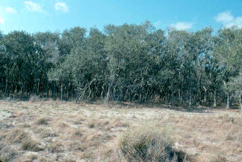
129. Sacahuista [Gulf cordgrass] prairie-motte of liveoak (probably more likely Quercus fusiformis= Q. virginiana var. fusiformis than Q. virginiana)- Mottes (Texan for grove or thicket) made up of various woody species developed within the overall bluestem-sacahuista prairie in much of the coastal sand plain of Texas. Shrub and tree species of such mottes include honey mesquite, granjeno or spiny hackberry (Celtis pallida), huisache (Acacia farnesiana), and lime pricklyash or colima (Zanthoxylum fagara) among several others, but liveoak is typically the most common and defining species.
Norias Division, King Ranch, Kenedy County, Texas. February, late hibernal or early vernal aspect. Range vegetation seen here could be interpreted as a patch of K-55 (Mesquite-Live Oak Savanna) in a matrix of K-69 (Bluestem-Sacahuista Prairie), or perhaps vice versa, if viewed from perspective of Landscape Ecology. Alternatively it could be viewed simply as an example of a generalized K-55 and the general SRM 719 (Mesquite-Liveoak-Seacoast Bluestem) rangeland cover type. Western Gulf Coastal Plain- Coastal Sand Plain Ecoregion 34d (Griffith et al., 2004).
Liveoak mottes and the liveoak range type was covered in this publication under Shrublands- Rio Grande Plains. The example presented here was included in the coastal tallgrass prairie chapter merely to show closeness and interaction of these range cover types and to prevent or, at least, reduce reader confusion (ie. to provide some continuity in envisioning the range vegetation of this region).

130. Seacoast bluestem sandhills range- The subtype or form of Gulf coastal tallgrass prairie that is dominated by seacoast bluestem, often, as in this example, a consociation of this species. This is generally accepted to be the more common form or expression of the Gulf coastal prairie. This author has observed that the seacoast bluestem subtype is more commonly bursh-infested than is the sacahuista [Gulf cordgrass] subtype. This could reflect the more widespread distribution of the seacoast bluestem subtype.
Physiographic features of the sandhills topographic type of the western Gulf coastal sands region were prominent in this photograph. Well-traveled viewers may have noted the similarity of these sandhills to those of the more widespread Nebraska Sandhills. (This comparison can be made herein by comparison of this landscape to that of tallgrass prairie in northcentral Nebraska portrayed in the chapter on interior tallgrass prairie.) Instructive in this regard was the mapping of soils in this area and that of a majority of the Nebraska Sandhills as Sands (Dry), Vallentine-Nueces Dune association in the general soils map of the United States according to the soil classification system of 1938 (United States Department of Agriculture, 1938).
Kenedy County, Texas. February. FRES No. 39 (Prairie Grassland Ecosystem). K-69 (Bluestem-Sacahuiste Prairie). SRM 711 (Bluestem-Sacahuista Prairie). Beardgrass Series 143.31 of Gulf Coastal Grassland Biotic Community 143.3 (Brown et al., 1998). Western Gulf Coastal Plain- Coastal Sand Plain Ecoregion 34d (Griffith et al., 2004).

131. Seacoast bluestem range- An arch-typical example of gulf coastal tallgrass prairie. Range vegetation shown in this photograph was (or, at least, approached) that of the regional climax plant community. Decades ago rangemen in North America accepted the vegetational concepts of either polyclimax of Tansley or the similar climax pattern theory of Whittaker hereby largely rejecting the monoclimax theory -- in pure form anyway-- of Clements. For instructional or intuitive purposes the student of range vegetation could revert to the monoclimax view and envision a region of land going through the geologic cycle theorized by William Morris Davis and weathering down to a peneplain with one climatic (= regional or zonal) climax vegetation. The regional or climatic climax of the Gulf of Mexico coastal prairie would be quite similar to the virgin upland seacoast bluestem on the small range landscape preented here.
Dominant species of this sandy upland range was seacoast bluestem with considerable Florida paspalum (Paspalum florida) and various dropseeds. Conspicuous forb was Texas croton (Croton texensis).
Willacy County, Texas. October. FRES No. 39 (Prairie Grassland Ecosystem). K-69 (Bluestem-Sacahuiste Prairie). SRM 711 (Bluestem-Sacahuista Prairie). Beardgrass Series 143.31 of Gulf Coastal Grasslamd Biotic Community 143.3 of Brown et al. (1998, p. 40). Western Gulf Coastal Plain- Lower Rio Grande Valley Ecoregion 34e (Griffith et al., 2004).

132. Sea oats-seacoast bluestem coastal prairie- An interrupted narrow strip of tallgrass prairie, a dry prairie (versus wet prairie and marsh), sporadically lines the Gulf Coast. This unique form of the vast tallgrass-dominated grassland in the heart of North America is the coastal terminus of a belt of humid climate-derived prairie that once extended southward from Manitoba to the Gulf. Some of the same dominant panicoid species extended throughout the latitude of this vast (once vast; now largely plowed or paved over) grassland. One of the most consistent of these species was little bluestem and its closely related taxa (both ecotypes and taxonomic varieties that have often been interpreted as separate species). The Gulf Coast "version" of little bulestem which is the dominant species of the coastal tallgrass prairie is sea coast bluestem (Andropogon littoralis, to most early day American agrostologists like Hitchcock, and Schizachyrium scoparium var. littoralis to recent authorities like Gould).
The distinguishing species of this unique form of bluestem prairie (ie. the key ecological species giving this vegetation it's distinctive quality, and it's designation) is sea oats (Uniola paniculata). The Society for Range Management (Shiflet, 1994) designated and described this rangeland cover type as the sea oats prairie. Sea oats were shown here in full-flower on low blow-out sand dunes that were stabilized by the roots and rhizomes of this eragrostoid grass. The spikelets of sea oats are probably the most laterally compressed of any North American grass and their beauty in the massive inflorescences provides as distinctive a quality as the picturesque grassland itself.
The view here is westward toward the mainland from this barrier island. Immediately behind this stand of sea oats is a wind-tidal flat formed by the combination of high heat, relatively constant temperature, persistent winds carrying salt particles, and saline soils. Wind-tidal and -deflation flats, deflation troughs, dunes of several kinds (eg. coppice, barchan, transverse, blow-out) and other miscellaneous local landforms create a patchwork of plant communities which are various seral stages in plant succession that probably terminates in a seacoast bluestem-sea oats climax.. Students of Plant Ecology should recall that many of the pioneering studies of plant succession in both America and Europe were done on sand dunes, the most famous of which was that of H.C. Cowles from which F.E.Clements took his grand model of "dynamic vegetation".
In the far background is an interdunal area dominated by seacoast bluestem as shown in detail in the succeeding slide.
Padre Island National Seashore, Texas. Hibernal aspect, February. FRES No. 39 (Prairie Ecosystem). Mapped by Kuchler as K-70 (Southern Cordgrass Prairie) which indicated that it was part of FRES No. 41 (Wet Grassland Ecosystem). But, as was the case for several North American range types, Kuchler mapping scale was too coarse (large or general) to include the narrow belt of dry prairie dominated by seacoast bluestem and sea oats within the more general coastal marsh and wet prairie zone. More precisely this is an outlier of K-66 or K-69 (a form of Bluestem Prairie). SRM 723 (Sea Oats). Part of the overly broad Beardgrass Series of Brown et al. (1998). Western Gulf Coastal Plains- Laguna Madre Barrier Islands and Coastal Marshes Ecoregion, 34i (Griffith et al., 2004).

133. Seacoast bluestem-sea oats prairie- This community most likely represents the potential natural terminal vegetation of the barrier islands and high dune zone of mainland beaches. Seen here is the stabilized blow-out dune zone which is the interior grassland of the barrier island. Foredunes just beyond the swash zone of the beach and wind-deflation flats and back-island dunes behind the flats (mainland-ward) act as borders and barriers to this seacoast bluestem-sea oats climax grassland.
The sea oats prairie, as it has been referred to (eg. Shiflet, 1994) based on the distinctiveness and specificity of this sand-binding rhizomatous grass, is found most consistently on the North American barrier islands such as Padre and Mustang Islands along the Texas coast. Vegetation of these barrier islands is complex and occurs as zones, the community compositions of which are determined by distance from the beach and strand (moving inland) or from the mainland (moving seaward or toward the coast). This example was found on north Padre Island with the extremely salty Laguna Madre and its back-island dunes behind these stabilized blow-out dunes. These dunes were populated primarily by the two dominant species with sea oats dominant on dune crests and seacoast bluestem dominant lower on the dune faces and the ground among adjacent dunes.
Within the overall seacoast bluestem-sea oats prairie there are numerous local sites (and even microsites) such as small fresh water or brackish marshes, blowouts, and deflation flats. All of these are various seral stages in the xerosere of the island with the stabilized sand dune and interdunal flats comprising the local climax grassland vegetation of which the dominants are typically sea coast bluestem and sea oats with such associate grasses as gulfdune paspalum (Paspalum monostachyum), bitter panicgrass (Panicum amarum), and, locally, big bluestem. Prominent forbs include whitestem wild indigo (Baptisia laevicaulis), largeleaf pennywort (Hydrocotyle bonariensis), and morningglory species (eg. Ipomoea stolonifera). All examples of vegetation presented in the following slides are of this general climax community.
The relatively flat (at least less choppy) land surface seen here in the foreground was largely a stand of seacoast bluestem with whitestem wild indigo the apparent associate species. Bitter panicgrass was also commonly interspersed around clumps of the cespitose bluestem.
Padre Island National Seashore, Texas. Hibernal aspect, February. FRES No. 39 (Prairie Ecosystem). Mapped by Kuchler as K-70 (Southern Cordgrass Prairie) which indicated it was part of FRES No. 41 (Wet Grassland Ecosystem), but, as was found for several North American range types, Kuchler mapping scale was too large or too general to include the narrow belt of dry prairie dominated by seacoast bluestem and sea oats within the more general coastal marsh and wet prairie zone. More precisely this is an "island" of K-66 or K-69 (a form of Bluestem Prairie). SRM 723 (Sea Oats). Beardgrass Series of Brown et al. (1998). Western Gulf Coastal Plains-Laguna Madre Barrier Islands and Coastal Marshes Ecoregion, 34i (Griffith et al., 2004).

134. Stabilized blow-out dune in climax grassland- Here in the interior of Padre Island, seacoast bluestem was the local dominant (with sea oats the associate species) atop a blow-out dune. With a slight shift in wind direction or with extended periods of higher wind speeds dune tops develop small blowouts which are covered by sea oats. Sea oats also quickly populate some of the more recent sand dunes and function as both a pioneer and a climax species (at least at local scale). The bare branches of the shrub extending above the dune in the center are of the deciduous black willow (Salix nigra). Sand dunes on the barrier islands frequently have persistently wet or moist layers of sand below the land surface that enables hydrophytes such as willow to persist in an otherwise xeric environment. Also, sand usually has high infiltration rates allowing dunes to absorb relatively large amounts of water in this sub-humid to humid precipitation zone.
Padre Island National Seashore, Texas. Hibernal aspect, February. FRES No. 39 (Prairie Ecosystem). K-66 or K-69 (a form of Bluestem Prairie): map units explained with two preceeding photographs. SRM 723 (Sea Oats). Beardgrass Series of Brown et al. (1998). Western Gulf Coastal Plains- Laguna Madre Barrier Islands and Coastal Marshes Ecoregion, 34i (Griffith et al., 2004).

135. Sea oats stabilizing sand dunes- This small dunes (and those barely visible in the background) were on a recent deflation plain where they were invaded by sea oats. This was an example of conditions and sites on which a climax species can also function as a colonizing species, at least locally when propagules are in close proximity to disturbance. The key role(s) of sea oats are what distinguish this as the sea oats prairie.
Padre Island National Seashore, Texas. February. At local area scale this is a unique form of FRES No. 39 (Prairie Ecosystem), K-66 or K-69. SRM 723 (Sea Oats). Western Gulf Coastal Plains- Laguna Madre Barrier Islands and Coastal Marshes Ecoregion, 34i (Griffith et al., 2004).

136. Big bluestem on the sea oats-seacoast bluestem prairie- That the prairies and marshes of the Gulf Coast are the southern extremity of the general tallgrass prairie vegetational region, Kuchler's Bluestem (Andropogon, Panicum, Sorgastrum) Prairie, is illustrated by local dominance of big bluestem on a microsite in the tallgrass variant form referred to as sea oats prairie. This grassland developed on a barrier flat which is a more-or-less level area of land on a barrier island that formed between the foredunes and the back-island dunes. Barrier flats usually originated as wind-deflation flats. The deflation flats formed when wind erosion removed loose materials like sand. Generally, the wind erodes sand and/or earth down to the levels at which moisture from the surface water table holds the sand in place, the particles remaining being either too heavy or bound to each other to be picked up. The eroded materials are re-deposited as dunes which are drier than the moist sand remaining (un-eroded) just above the ground water level. Wind not only moves geologic materials directly but also indirectly as wind-driven tides which can come from both the sea (eg. the Gulf) and from any bodies of water situated between the barrier island and the mainland (eg. the Laguna Madre to the west, the mainland-side, of Padre Island). When the wind-driven tides from saline lagoons (eg. Laguna Madre) flood lower portions of islands this salty water carries away suspended soil and parent materials like sand (ie. water erosion). It also floods these low sites with water several times saltier than ocean water. These processes are the basis of the dynamic nature of dune landscapes such as often found on lake shores and barrier islands.
Barier flats and local topographic variations within them often are more favorable for plant production. This portion populated by big bluestem may have been a more fertile or, as is generally the case for wind-deflation flats,a more mesic microsite. The size, habit, and physiogonomy of the big bluestem stand attest to the affinity of the general sea oats-seacoast or little bluestem prairie as a part of the tallgrass prairie. From the standpoint of plant succession the vegetation on these flat portions of barrier islands are the equivalent of the regional climax with the barrier flat being the peneplain in the geologic cycle perspective of William Morris Davis that was the basis of the Clementsian monoclimax theory. The occurrence of big bluestem as a local dominant and seacoast bluestem as overall dominant is evidence for the affiliation of this relatively restricted range type with the general bluestem prairie that extended over so much of the latitude of central North America.
Padre Island National Seashore, Texas. hibernal aspect, February. FRES No. 39 (Prairie Ecosystem). K-66 or K-69 (one form of the Bluestem Prairie). SRM 723 (Sea Oats). Beardgrass Series of Brown et al. (1998). Western Gulf Coastal Plains- Laguna Madre Barrier Islands and Coastal Marshes Ecosystem, 34i (Griffith et al., 2004).

137. Composite view of the seacoast bluestem-sea oats prairie- This vegetated barrier flat supported a diverse plant community which served as a general model in minature of the coastal prairie and marsh portion of the tallgrass (= bluestem) prairie. The nature of a barrier flat in the interior of a barrier island and the general geologic processes forming barrier flats was presented under the immediately preceding slide. As explained above, barrier flats begin as wind-deflation flats (= wind-deflation troughs). Within the general wind-deflation trough or flat (which in time becomes a vegetated barrier flat) there are lower areas running across (crossways or perpendicular to) the general or whole barrier flat that extends roughly from the foredunes to the back-island dunes. These deeper but narrower wind-deflation troughs occur within the general deflation trough extending to various distances across it thereby creating a micro-relief that can be pictured as a washboard or corrogated sheet metal. These deeper wind-deflation flats ("mini-flats") formed during droughts or periods when the sand was drier than that for the average of the entire time sequence over which the whole, the overall, deflation flat formed. As the sand was drier for a greater depth in the soil profile the wind could erode away more of the profile (ie. "deeper down"). Over time the result was a micro-topography of troughs within the overall or general trough (ie. much like a washboarded road). When rainfall returned to the average for that of the entire chronological sequence under which the general or entire wind-deflation flat (and, ultimately, the barrier flat) formed the deeper "trenches" (ie. the narrower wind-deflation troughs) filled up with water. During periods of average or above average precipitation the ground water table is closer to the land surface of the barrier flat such that water rises to the surface in the deeper but narrower troughs. This creates local areas of sub-irrigated prairies, fresh water marshes, or small, often ephemeral, lakes within the extent of the overall barrier flat (the vegetated land located between the dunes at the seaward and mainland edges of the barrier island). Such conditions existed on the heavily vegetated barrier flat shown in this slide.
A fresh water lake formed by ground water rising to the surface of one of the deeper, drought-induced, small wind-deflation troughs in the base floor of a wind-deflation-derived basal flat (far horizon). Subirrigation was the edaphic penomenon responsible for the wet (at least ephemerically wet) prairie or, perhaps, the marsh community in the foreground of this landscape. The round, conspicuously green leaves are marsh or largeleaf pennywort (Hydrocotyle bonariensis), an indicator species of very mesic to hydric soil conditions. Sandwiched between the lake and its adjacaent marsh and the wet prairie is the predominant mesic edaphic habitat supporting bluestem prairie the dominant of which was seacoast bluestem.
The combination of natural fresh water lakes and abundant forage from tallgrass prairie and marsh made the landscape of this barrier island ideal habitat for numerous species of wildlife from waterfowl to white-tailed deer. With coming of the white man it served as the natural resource base for ranching empires. Research into the cattle-ranching frontier revealed unequivocally that the roots of this industry were in the soil of the coastal prairies and marshes area. (See for eg. Jordan, 1993). The barrier flats of such barrier islands as Padre Island served as critical cattle range for several ranching empires, including for a brief period King Ranch.
Students can get a good introduction to the geology, ecology, and human history of barrier islands from the Padre Island guide book by Weise and Shite (1980) from which much of the above explanation was extracted.
Padre Island National Seashore, Texas. Hibernal aspect, February. FRES No. 39 (Prairie Ecosystem). K-66 or K-69 (one variant of Bluestem Prairie). Inherent problems with large-scale mapping units such as the Kuchler units of potential vegetation were discussed with the first two slides that introduced this rangeland cover type (SRM 723, Sea Oats). Beardgrass Series of Brown et al. (1998). Western Gulf Coastal Plains- Laguna Madre Barrier Islands and Coastal Marshes Ecoregion, 34i (Griffith et al., 2004).
The following series of photographs showed range vegetation and plant species on South Padre Island near the southern terminus of Padre Island, the longest barrier island on Earth. At this location the cross section of Padre Island is relatively narrow so that topographic zones from seashore to back island dunes and Laguna Madre are comparatively close together (ie. the extent or distance of island crosss section is short so that the different topographical areas are compressed). The following treatment of range vegetation on South Padre Island followed the classic study by Judd et al. (1977) in which this part of the barrier island was divided into five longitudinal topographic zones (Judd et al., 1977, ps. 31, 33, 46, and Figure 2, p. 35). Topographic zones were: 1) foreshore, 2) backshore, 3) primary dunes, 4) secondary dunes and vegetated flats, and 5) tidal flats. In addition to these five the present author recognized the foredune portion of primary dunes.
This topographic sequence was reasonably consistent with the greater detail of island morphology and glossary given by Weise and White (1980). Terms used by these latter authors differed from that used by Judd et al. (1977), but most terms seemed to be synonymous as for example: 1) forebeach (= foreshore), 2) backbeach (= backshore), and 3) foredune and foredune ridge (= primary dunes). The term tidal flat was used by both groups, but the equivalent of secondary dunes by Judd et al. (1977) could not be found in Weise and White (1980).
The topographic sequence was to considerable degree a toposequence (vs. chronosequence) of primary plant succession (Barbour et al., 1999, p. 274-276).

138. Waves over the foreshore (= forebeach)- Waves from Gulf of Mexico washing over the foreshore, the landward (= inland) limit of which is the inner swaqsh zone. South Padre Island, Cameron County, Texas. October.

139. Foreshore- The outermost (seaside-most) edge of the forebeach over which waves from the Gulf of Mexico wash. Such waves leave varying waterlines inland-ward as the extent or limit of wave action varies with changes in the reaches of tides or storm surges from events like hurricanes. The inner layer of the swash zone or foreshore is the debris line which is clearly marked by wavy lines of shells, seaweed, dead fish, etc. that corresponded to farthest inland reach of waves.
Immediately behind (inland from) the forebeach (adjacaent to and inland from the debris line) is the backbeach (= backshore). The backbeach begins immediately inland from the debris line and extends to the foredunes (= primary dunes).
South Padre Isalnd, Cameron County, Texas. October.


140. Foredunes- The land surface feature viewed here is known as primary dunes. Foredunes or primary dunes are the first ridge or series of ridges just inland from the bachshore (= backbeach). Generally the backshore is subject to direct wave affects that come into play only from unusual wave action (eg. extreme wave reach with hurricane storm surges). The first part of foredunes is often kept in what could be interpreted as seral successional stages because extreme winds, salt-sparay, erosion from wind and waves of severe or extreme storms (eg. hurricanes) prevents advancement to climax, or, at least, to the climax vegetation of the interior secondary dunes. Another way of viewing this is to regard the topographic sequence of range vegetation that extends from plant communities on foredunes through backdunes and then tidal flats each as climax range vegetation that develops on different range sites corresponding to the different topographic zones. For similar discussion, including other literature on this subject, see Judd et al. (1977, p, 46).
Either way, the successional "actors" and the "cast of characters" of each zonal or topographical habitat of coastal dunes is unique (different from) the others and has a different potential natural vegetation (ie. different range site potentials). If this toposequence itself is regarded as a sere, then the edaphic-topographic continuum culminates in the interior of the dune landform (ie. on the backdunes or primary dunes).
On foredune rangeland there is a vegetational mosaic that is comprised of different plant communities or populations of species which correspond to localized disturbances (ie. disturbance micro-sites), especially dune erosion caused by either wind or wave action. An example of this was evident in right foreground of this photograph. Local patches of vegetation differed in plant species composition ranging from stands or micro-consociations of sea oats to "mini-gardens" of sea ox-eye (Borrichia frutescens), camphor daisy (Machaeranthera phyllocephala), goat's foot morning glory or railroad vine (Ipomoea pes-caprae var. emarginata), fiddleleaf or beach morining glory (I. stolonifera), seashore dropseed (Sporobolus virginicus), beach tea or beach croton (Croton punctatus), and partridge pea (Chamaerista fasciculata). Species other than partridge pea and camphor daisy are perennials.
South Padre Island, Cameron County, Texas. October.

141. Blowout atop foredune- Wind action eroded the depression known as a blowout on the highest part of the front ridge of foredune. Not to worry, a long stolon of goat's foot morning glory is crosssing the wound in the dune to anchor sand and maintain stability of the dune surface. Sea oats were highlighted against the coastal sky at the rarthest crest of the forefunes.
South Padre Island, Cameron County, Texas. October.

142. Running over a blowout- Goat's foot morning glory stolon growing over a cut-face portion of coastal foredune. South Padre Island, Cameron County, Texas. October.

143. Beach comber buddies- Goat's foot morning glory and seashore dropseed on a foredune of the dune form of tallgrass prairie. This patch of seral range vegetation and the one immediately below were examples of the "mini-gardens" growing on the sere of Gulf Coastal dunes of which grassland of tallgrass species is the climax (see below).
South Padre Island. Cameron County, Texas. October.

144. Salad bowl over a blowout- Blowout on a foredune was being invaded and stabilized bu a mixture of goat's foot morinig glory, beach tea, camphor daisy, and showy partridge pea. South Padre Island, Cameron County, Texas. October.

145. Local assemblage of seral species- Goat's foot morning glory and beach tea or beach croton seemed to be enjoying each other's company on this small blowout of a foredune. Such local aggregations constitute seral stages on the dune sere of coastal tallgrass prairie. South Padre Island. Cameron County, Texas. October.

146. Laying claim to a patch of earth- Goat's foot morning glory on a freshly eroded spot on primary dune (= foredune). This is an example of patch or gap dynamics writ small. Concept of vegetation development on the gap or patch is the same as if it was a fallen tre in the forest. In fact, wind is the agent of denudation in both instnces. South Padre Island. Cameron County, Texas. October.


147. Goat's foot morning glory or railroad vine (Ipomoea pes-caprae var. emraginata)- This marvelous soil-binder is also a strikingly beautiful native plant species. Foredune on Soputh Padre Island, Cameron County, Texas. October.

148. Another trail of glory- Beach or fiddleleaf morning glory (Ipomoea stolinifera) is also an excellent soil-binding range species. This individual was making itself right at home stabilizing a blowout on a primary dune. South Padre Island, Cameron County, Texas. October.


149. Fiddleleaf or beach morning glory- Stolon of fiddleleaf morning glory with details of leaves and inflorescence featured. South Padre Island, Cameron County, Texas. October.

150. Carpet of tea- Beach tea or beach croton (Croton punctatus) growing on the foremost (seaside) crest of a foredune. South Padre Island, Cameron County, Texas. October.
Coastal tallgrass prairie vegetation on foredune-primary dunes - The next three photographs showed range plant communities on the forefront (sea-most or Gulf of Mexico side) of coastal dunes. Specific lessons in addition to species composition and community structure were presented such that individual photographs were given specific numbers (in contrast to some series of phpotographs shown below which stressed range community composition, physiogonomy, and structure). Successional relationships and classification of vegetation (range ecosystems, types, ecoregions, etc.) was presented in captions for individual photographs.

151. Pardners in stabilization- Sea oats and goat's foot morning glory or railroad vine were growing on the tallest crest of the foremost primary dune. The soil was held for-- now. Judd et al. (1977, ps. 40, 41, 44, 46) concluded that primary dunes were dominated by fiddleleaf morning glory and sea oats whereas secondary dunes supported the dominant seacoast bluestem. If the coastal dune toposequence was seen as a single sere with one climatic (or, perhaps, topographic) climax the terminus of plant succession on coastal dunes would be the seacoast bluestem range community of secondary dunes. If the dune toposequence was viewed as a series of climax/mature range sites each with its own potential climax vegetation then sea oats would be climax for much of the foredunes-primary dunes range site(s) while seacoast bluestem-dominated vegetation would be the climax for secondary dunes.
This latter view would visualize Gulf of Mexico coastal dunes as a series of climaxes (ie. polyclimax or climax pattern theories and not monoclimax theory are most appropriate). This view was consistent with the recognition and discusssion of rangeland cover types by the Society for Range Management (Shiflet, 1994) which recognized the two cover types of Bluestem-Sachauista Prairie (SRM 711) and Sea Oats (SRM 723) for coastal prairie. SRM 711 extends farther inland and probably has more variant forms. Likewise, Kuchler (1964, ps. 72, 77) distinguished between and recognized both a Sea Oats Prairie (Uniola-Andropogon) and Bluestem-Sacahuista Prairie (Andropogon-Spartina). Seacoast bluestem (shown as Andropogon littoralis) was listed for both of these. It seemed likely that treatment of Gulf of Mexico coastal prairie by the Society for Range Management (Drawe in Shiflet, 1994) followed-- with complete justification-- the precedent of Kuchler (1964, ps. 72, 77).
South Padre Island, Camreon County, Texas. October. Garrison et al. (1977) omitted Sea Oats Prairie (Kuchler, 1964, p. 72), but would likely be FRES No. 39 (Prairie Grassland Ecosystem). K-72 (Kuchler, 1964).. SRM 723 (Sea Oats). Beardgrass Series 143.31 (whould be Sea Oats Series is such was presented) of Gulf Coastal Grassland Biotic Community 143.3 of Brown et al. (1998, p. 40). Western Gulf Coastal Plain- Laguna Madre Barrier Islands and Coastal Marshes Ecoregion 34i (Griffiith et al., 2004).

152. Assembled on a foredune- Range vegetation on the crest of the foremost foredune (leading edge of primary dunes) consisting of sea oats (Uniola paniculata), goat's foot morning glory, beach tea, seashore dropseed, and sea ox-eye.
South Padre Island, Cameron County, Texas. October. FRES No. 39 (Prairie Grassland Ecosystem). K-72, Sea Oats Prairie (Kuchler, 1964). SRM 711 (Sea Oats). Beardgrass Series 143.31 (should be Sea Oats Series) of Gulf Coastal Grassland Biotic Communuty 143.3 of Brown et al. (1998, p. 40). Western Gulf Coastal Plain- Laguna Madre Barrier Islands and Coastal Marshes Ecoregion 34i (Griffith et al., 2004).

153. Sea oats coastal prairie- Colony of sea oats along with partridge pea, goat's foot morning glory, fiddleleaf morning glory, camphor daisy, sea ox-eye, and seashore dropseed formed a species-rich range community on crest of foredune. Secondary dunes (dominated by seacoast bluestem with sea oats as sometimes associate species) were visible in background. Secondary dunes were treated immediately below.
South Padre Island, Cameron County, Texas, October, peak standing crop. FRES 39 (Prairie Grassland Ecosystem).. K-72, Sea Oats Prairie (Kuchler, 1964). SRM 711 (Sea Oats). Beardgrass Series (there should be a Sea Oats Series) 143.31 of Gulf Coastal Grassland Biotic Community 143.3 (Brown et al., 1998, p. 40). Western Gulf Coastal Plain- Laguna Madre Barrier Islands and Coastal Marshes Ecoregion 34i (Grifith et al., 2004).
Coastal tallgrass prairie vegetation on secondary dunes- The series of three photographs displayed immediately below presented virgin tallgrass prairie range on secondary dunes over which seacoast bluestem was the dominant species with sea oats and common reed or carrizo overall associate species (each of the latter two grasses were sometimes locally dominant). This was the interior of the topographic complex (landscape transect) that extended from foreshore to tidal flat and mainland. The range environment of this interior of the dune complex was generally the most moderate (the mild part of dune habitat; least severe microclimate) with less drastic relief or topographic features, least consistent wind velocity, modest exposure to salt spray and tidal wave inundation, etc.
In other words, range plant habitat within secondary dunes or in interior of the dune complex more closely resembled inland parts of the Coastal Prairies and Marshes vegetational area. As such, tallgrass prairie vegetation of secondary dunes could be seen as the climax for the dune toposequence. Alternatively, each of the topgraphic zones of the forebeach to mainland range landscape could be seen as having its own potential natural vegetation that is synonymous with climax vegetation. This polyclimax or climax pattern perspective was consistent with classification of pre-Columbian vegetation by Kuchler (1964) and with designation-description by the Society of Range Management (Shiflet, 1994) of rangeland cover types for both Bluestem-Sachauista Prairie (SRM 711) and Sea Oats (SRM 723). SRM 723 was treated immediated above; SRM 711 was covered below.

154. Tallgrass prairie on coastal secondary dunes- Interior of the foreshore to tidal flat landscape (toposequence) consisted of a range vegetation existing as a patchwork (= mosaic) of relatively inconspicuous yet distinctive grassland communities. These various tallgrass prairie units of range vegetation ("bits of mosaic") could be determined by their dominant plant species. Such localized habitats and their prairie plant communities included 1) seacoast bluestem (far and away the major one), 2) common reed or carrizo, and 3) sea oats. In the view of Landscape Ecology common reed- and sea oats-dominated communities were patches within the seacoast bluestem matrix.
The sea oats range community was similar to that described for sea oats on foredunes-primary dunes. Common reed grew as either almost single-species stands (ie. as species populations) or with seacoast bluestem as an associate species. Thus, again, seacoast bluestem was the overall dominant species of secondary dunes.
South Padre Island, Cameron County, Texas. October, various phenological stages of key plant species. FRES No. 39 (Prairie Grassland Ecosystem). K-69 (Bluestem-Sacahuista Prairie). Seacoast bluestem form or variant of SRM 711 (Bluestem-Sacahuista Prairie). Beardgrass Series 143.31 of Gulf Coastal Grassland 143.3 Biotic Community (Brown et al., 1998, p. 40). Western Gulf Coastal Plain- Laguna Madre Barrier Islands and Coastal Marshes Ecoregion 34i (Griffith et al., 2004).

155. Climax grasses on stabilized secondary dunes - On interior of the forebeach to tidal flat-mainland toposquence range vegetation is a mosaic pattern of plant communities readily distinguised by local dominant grass species. One of these local or "patch" communities is that of common reed, carrizo, or Roseau cane (Phragmites communis= P. australis). This patch often exist more as a colony (a population or single-species stand) inter-mixed with ("infiltrated" by) with some seacoast bluestem (Andropogon littoralis= Schizachyrium scoparium var. littoralis). Such a botanical assemblage was growing in foreground of range vegetation presented here. A larger community dominated by seacoast bluestem was located directly behind that dominated by common reed. Seacoast bluestem was the dominant range plant of vegetation shown in this slide, including that of most of the interdunal vegetation such as was visible as the brown irregular configuration in midground. Seacoast bluestem is distinguished from little bluestem (A. scoparius= S. scoparium var. frequens) by presence of rhizomes in the former. The morphological feature of scaly rhizomes is an obvious evolutionary adaptation to dune habitat.
South Padre Island, Cameron County, Texas. October, pre-bloom to early anthesis stage in carrizo. FRES No.39 (Prairie Grassland Ecosystem). K-69 (Bluestem-Sacahuista Prairie). SRM 711 (Bluestem-Sacahuista Prairie). Beardgrass Series 143.31 of Gulf Coastal Grassland 143.3 (Brown et al., 1998, p. 40). Western Gulf Coastal Plain- Laguna Madre Barrier Islands and Coastal Marshes Ecoregion 34i (Griffith et al., 2004). .

156. Climax tallgrass prairie on Gulf Coast secondary dunes- Range vegetation that is the potential natural vegetation of the interior of the toposequence extending from foreshore through tidal flat-mainland landscape. This is the most moderate (least extreme habitat) in the rangeland complex that was typical of the topography of range vegettion extending across the Padre Island System, the longest barrier island on Earth.
Range vegetation in the foreground was dominated by the rhizomatous seacoast bluestem with sea oats as associate species. This was an example of the ultimate expression of coastal tallgrass prairie. Foreground vegetation had developed just behind the last ridge of the higher primary dunes that were dominated by sea oats so that this range vegetation was a transition between the sea oats cover type and the seacoast bluestem prairie of the secondary dunes.
This was an example of hard-to-call range types given the transitional nature of this range vegetation. Makes rangemen realize that there was some merit to the individualistic concept of plant associations advocated by the courageous Gleason (1926). (No, it did not convert this Clementsian author into a Gleasonian-- not even close.)
South Padre Island, Cameron County, Texas. October. FRES No. 39 (Prairie Grassland Ecosystem). K-69 (Bluestem-Sacahuista Prairie) or perhaps K-72 (Sea Oats Prairie) of Kuchler (1964), but more of the former.Likewise, more like SRM 711 (Bluestem-Sacahuista Prairie) than SRM 723 (Sea Oats). Beardgrass Series 143.31 of Gulf Coastal Grassland Biotic Community 143.3 (Brown et al., 1998). Western Gulf Coastal Plain- Laguna Madre Barrier Islands and Coastal Marshes Ecoregion 34i (Griffith et al., 2004).

157. Characters of the Gulf Coast secondary dunes- Climax range vegetation of tallgrass prairie that developed on secondary dunes of the Padre Island System. Seacoast bluestem was dominant with common reed and sea oats locally dominant and serving as associate species. There were trace amounts of seashore dropseed. The major and conspicuous forb was seacoast goldenrod (Solidago sempervirens var. mexicana). This stalwart composite was common locally but not widespread enough to be an associate species. It was a distinctive indicator species. Other forbs present-- in small proportions --were species of primary dune plant communities such as sea ox-eye, camphor daisy, partridge pea, and goat's foot morning glory.
South Padre Island, Cameron County, Texas. October. FRES No. 39 (Prairie Grassland Ecosystem). K-69 (Bluestem-Sacahuista Prairie). SRM 711 (Bluestem-Sacahuista Prairie). Beardgrass Series 143.31 of Gulf Coastal Grassland Biotic Community 143.3 (Brown et al., 1998). Western Coastal Plain- Laguna Madre Barrier Islands and Coastal Marshes Ecoregion 34i (Griffith et al., 2004).

158. Beacons on the outskirts- Sea oats on a disturbance gap at the edge of secondary dunes. Wind was probably the agent of denudation that resulted in succesful invasion of the patch by a grass species that can be interpreted as a persistent pioneer plant, a species that migrates to and establishes on a disturbance area and persist-- usually in lesser relative proportions --into the climax vegetation.
South Padre Island, Cameron County, Texas. October, peak standing crop.

159. Sea oats (Uniola paniculata)- An aestically pleasing colony of sea oats on the inner (landward) part of primary dunes. Some seashore dropseed slipped in to get "its picture took" too. Cameron County, Texas. October.

160. Sea oat panicle- Many beginning agrostologists learn that sea oats has the ultimate in laterally compressed spikelets. By the way, the panicle of sea oats is also the ultimate in a lasting floral arrangement for home or office decoration-- and they're all natural. Be a range patriot: fly the flag of native grasses. Cameron County, Texas. October.


161. Common reed, carrizo, or Rouseau cane (Phragmites communis= P. australis)- The specimens shown here were growing at the edge of a freshwater marsh in the interior of secondary dunes. South Padre Island, Cameron County, Texas. October, early anthesis phenological stage..

162. Reed spikelets- Portion of panicle of common reed or Rouseau cane featuring spikelets. Cameron County, Teaxas. February, seed ripe phenological stage.


163. Another native, cool-season, prairie grass- Winter bentgrass (Agrostis hyemalis) on moist to wet local habitat on tallgrass prairie in western Ozark Plateau. This is a minor species other than in local mesic microsites. It was included here to give an idea as to the great species diversity of tallgrass prairie. Even in southern areas native, winter, grasses grow alongside warm-season, perennial, panicoid grasses. Winter bentgrass has generally been regarded as a short-lived perennial (Gould, 1975, p. 140). It grows on both interior and coastal tallgrass prairie.
Ottawa County, Oklahoma. Late May, maturing grain to early grain-ripe phenological stages.


164. Dainty panicles on tallgrass prairie- Panicles and spikelets of winter bentgrass. These flowers were on some of the same plants shown in the immediately preceding slide. Ottawa County, Oklahoma. Late May, early grain-ripe stage..


165. Seacoast goldenrod (Solidago sempervirens var. mexicana)- It would be hard to imagine range, especially tallgrass prairie range, without a composite. And this is a composite worthy of climax tallgrass prairie on the secondary dunes of the longest barrier island on the planet. As a bonus there was a good sample of seashore dropseed as attendant to this royal forb of the coastal dunes.
Photograph of infloresence provided students with an example of determinate growth in which there is no more apical growth after flower organs have developed. More to the point in this photograph is the phenomenon of determinate inflorescence or determinate flowering versus indeterminate inflorescence or indeterminate flowering. Determinate is the condition in which the terminal (top or upper) flower or the innermost flower is the oldest or most mature such that it occurs at terminal part or innermost part of flower cluster. In determinate flowering the blooming sequence is downward (top to bottom) and outward (inside to outside) in the inflorescence. Floral development of the first flower determines or designates the ultimate size of the inflorescence in determinate flowering. An indeterminate inflorescence is the opposite.
OK, range children. Is this a determinate or indetermminate inflorescence?
The goldenrod species are members of the aster tribe (Astereae) of the aster or sunflower family (Asteraceae or Compositae).
South Padre Island, Cameron County, Texas. October, full bloom stage.

166. Sea ox-eye (Borrichia frutescens)- One of the dominant shrubs on coastal dunes and tidal flats of the North American Gulf Coast. Recall from discussion of the preceding species that something would seem to be missing from the typical range plant community if there were no composites. So here's another yellow-flowered composite.
Sea ox-eye is usually more abundant on more severe sites along the Gulf Coast such as foredunes and tidal flats. It is frequently associated with fiddleleaf and goat's foot morning glory and beach croton. All of these range species are halophytes, at least by most criteria.
Cameron County, Texas. October.

167. Inflorescence of sea ox-eye- This member of the Compositae is in the Heliantheae, one of the largest tribes of this very large taxonomic family of range plants. Cameron County, Texas. October.

168. Camphor daisy (Machaeranthera phyllocephala)- Still yet another DYC (Damn yellow Composite). This species is another member of the aster tribe. It is an annual that is generally more common on the harsher sites of the coastal dunes and tidal flats as where there is more salt sparay, wind, inundation by waves, etc.By most criteria camphor daisy is a halophyte.
Cameron County, Texas. October.

169. Shoot apex of camphor daisy- The twisted or curled leaves with their serrated margins are an easily recognized feature of this halophytic composite. Cameron County, Texas. October.

170. Another camphored coastal character- Camphorweed (Heterotheca subaxillaris) growing on locally disturbed microsite of coastal marsh that was near the beach along the Gulf of Mexico. This native annual or biennial composite is a weed on land that has been overgrazed, farmed, or otherwise disturbed. Said another way (and with a positive interpretation from an ecological perspective) camphorweed is a colonizer or pioneer plant species that prepares the way for colonization (invasion) plant species of higher successional order. The specimen presented here was growing on a streatch of beach that had been eroded recently by the storm surge of a hurricane.
Camphorweed is widely distributed with a species range that extends from New York to California and south to Mexico and the southern tip of Florida. This species varies considerably in habit depending on habitat, including seasonal growing conditions.
McFadeen National Wildlife Refuge, Jefferson County, Texas. February; peak bloom to early fruit phenological stages.


171. Camphored composite- Heads of camphorweed growing on a disturbed (hurricane damaged) area of coastal marsh along the western Gulf Coast. Darker late-evening light brought out the darker, richer shade of yellow in these petals. The head of camphorweed has disk and ray flowers, both being fertile (achenes from disk flowers have a pappus, are plumed, while achenes of ray flowrs lack a pappus or are unplumed).
McFadeen National Wildlife Refuge, Jefferson County, Texas. February; peak bloom to early fruit phenological stages.
One of the-- if not, the --most unique range plant communities in the toposequence, the vegetational topographic zones, of the Padre Island System is freshwater (= fresh) marsh. This wetland range community is probably the smallest (acreage- or area-wise) of any of the range cover types in this barrier island system. Judd et al. (1977, p. 41) explained that fresh marshes were infrequent components of secondary dunes that formed in hollows or flats when saturated soil conditions existed due to a combination of low elevation and "drainage configuration" (pattern of land elief).
An example of fresh marsh was presented immediately below to provide a more complete portrayal of the range vegetation of the Coastal or Gulf Prairies and Marshes land resource or vegetational area (Thomas in Gould, 1962, ps. 8-9 and Correll and Johnston, 1979, ps. 3-4).

172. Fresh marsh in coastal dunes- Freshwater marsh that developed at inner edge (mainland side) of secondary dunes. The Padre Island system of barrier islands as well as the Gulf Coast of the North American mainland includes: 1) saltwater or, simply, salt marshes, 2) brackish (a mixture of saline and fresh water), and 3) freshwater or, simply, fresh marshes. Factors such as wave inundation, freshwater sources ranging from springs to rivers, soil drainage, gulf water intrusion determine whether a given herbaceous wetland is salt, brackish , or fresh marsh.
Range vegetation of this fresh marsh was botanically diverse wetland community of slender, southern, or sometimes, common cattail (Thypa domingensis), common reed or Rouseau cane, Gulf cordgrass, rushes (Juncus spp.), blunt spikerushe or blunt spikesedge (Eleocharis obtusa), seacoast bluestem, Indiangrass, sand dune paspalum, and seashore goldenrod. The conspicuous gray-leaf species was the shrub, sea ox-eye. Cattail was the apparent fresh marsh dominant based on relative cover, plant density, and size (height and basal cover) of mature plants (and, probably by extension, ecosystem function).
South Padre Island, Cameron County, Texas. October. FRES No. 41 (Wet Grassland Ecosystem). Variant of K-70 (Southern Cordgrass Prairie). Variant of SRM 711 (Cordgrass). In examples shown in of classification system of Brown et al. (1998, p. 45) there was neither a Cordgrass nor Cattail Series for Gulf Coastal Maritime Marshland Biotic Community 243.3. These should be "filled-in": this would be Cattail Series. Western Gulf Coastal Plain- Laguna Madre Barrier Islands and Coastal Marshes Ecorgeion 34i (Griffith et al., 2004).

173. Turf of fresh marsh- Examination of range vegetation on the Gulf Coast (barrier island) fresh marsh presented in the immediately preceding slide. This close-in view revealed common reed, rush species, seacoast bluestem, Indiangrass, sand dune paspalum, spikerush, and the conspicuous low shrub, sea ox-eye. Gulf coregrass and slender or southern cattail were common on this fresh marsh, but were not in this photo-plot of marsh vegetation.
South Padre Island, Cameron County, Texas. FRES No.41 (Wet Grasslands Ecosystem). K-70 (Southern Cordgrass Prairie), variant thereof. Variant of SRM 726 (Cordgrass). In the classification system of Brown et al. (1998, p. 45) would best be described as a Cattail Series of Gulf Coastal Maritime Marshland Biotic Community 243.3 but there was a Cattail Series (243.11) only for Southeastern Maritime Marshland 243.1. Western Gulf Coastal Plains- Laguna Madre Barrier Islands and Coastal Marshes Ecoregion 341 (Griffith et al., 2004).

174. Hedge around the marsh- Dwarf, shining, or winged sumac (Rhus copallina var latifolia) growing at edge of the freshwater marsh shown in the preceding slide. Cameron County, Texas. October.

175. Shining or dwarf sumac- Ripening fruit and glossy leaves (hence, the adjective "shining") of dwarf, winged, or shining sumac of the specimen introduced in the preceding slide. Cameron County, Texas. October.

176. Saltmarsh bulrush (Scirpus maritimus var. macrostachyus= S. robustus)- Extensive colonies of this aquatic grasslike plant frequently form in marshes along the Gulf Coast. The example presented here had developed on a tidal flat salt marsh just inland from the black mangrove (Avicennia germinans) zone and about 250-300 yards from the fresh marsh and its range plants that were shown immediately above.
Cameron County, Texas. February, anthesis phenological stage.


177. Saltmarsh bulrush in bloom- Detail of flowering shoot and inflorescence of saltmarsh bulrush on a tidal flat saltmarsh.
Cameron County, Texas. February, anthesis stage.
Tidal flats are one of the prominent longitudinal topographic zones described by Judd et al. (1977) and listed above. Following the just-completed display and description of foreshore and backshore, and then the same for range vegetation on primary and secondary dunes, coverage was next extended to tidal flats. The tidal flat zone was the largest (longitudinally and acreage-wise) of the topographic zones, but it had the least vriation in land surface (flat vs. duney or hummocky relief or micro-topography).
Even with little variation in relief there was substantial difference in range vegetation on tidal flats. Variation in range plant communities was more in species composition than in physiogonomy or structure. This Tidal flat vegetation is predominately salt marsh which reflects the controlling and defining phenomenon of saltwater intrusion from the Gulf of Mexico due to tides and flooding including storm surges caused by hurricanes. Fluctuation and mean differences in salinity along with edaphic and other environmental factors results in a patchwork or mosaic of range plant communities on salt marshes. Frequently this spatial variation in vegetation exists as zones of different plant species. Zonation of range vegetation on Gulf of Mexico salt marsh was apparent in photographs presented below which were arranged as three series each with two or more photographs of overall range vegetation followed by slides of major plant species that comprised the range plant communities on what were obviously different habitats (possibly different range sites or variants of a range site) on the tidal flat.
All range vegetation was contiguous (one road separated two units of land) and part of the Laguna Atascosa National Wildlife Refuge in Cameron County, Texas.


178. Tidal flat salt marsh- Two landscape views of tidal flat range in Coastal Prairies and Marshes vegetational area. This range plant community was the lowest elevational portion of a tidal flat and subject to frequent intrusion of saltwater from the Gulf of Mexico. Soil surface was usually muddy from overflow of gulf water. Species composition of the plant community of this "super-salty" range site consisted of mostly of shoregrass (Monanthochloa littoralis) and maritime saltwort (Batis maritima) with lesser proportions of sea blite (Suaeda linearis) and sea ox-eye.
Laguna Atascosa National Wildlife Refuge, Cameron County, Texas. October. FRES No. 41 (Wet Grasslands Ecosystem). No Kuchler unit was specific for this portion of what by defalut would be a generic K-70 (Southern Cordgrass Prairie). Rio Grande (marshhay cordgrass and seashore saltgrass) variant of SRM 726 (Cordgrass). Gulf Coastal Maritime Marshland 243.3- Saltgrass Series 243.31 of Brown et al. (1998, p. 45; it would be a Shoregrass Series if there was one, and maybe there should be). Western Gulf Coastal Plain- Laguna Madre Barrier Island and Coast Marshes Ecoregion 34i (Griffith et al., 2004)

179. Plant members of a tidal flat range- Photo-plot of vegetation on the Gulf of Mexico tidal flat shown in the two immediately preceding photographs. Sea blite, shoregrass, and maritime saltwort. Lagunda Atascosa National Wildlife Refuge, Cameron County, Texas. October.

180. Another shot of tidal flat folks- Photo-quadrant of range plants on the Gulf of Mexico tidal flat presented above. Martime saltwort and shoregrass in close association. Laguna Atascosa National Wildlife Refuge, Cameron County, Texas. October.

181. Bearing fruit with the salt- Fruit-bearing bare shoot of sea ox-eye in a colony of maritime saltwort. Laguna Atascosa National Wildlife Refuge, Cameron County, Texas. October.

182. Sample of a stand of shoregrass (Monathochloe littoralis)- Shoregrass forms dense colonies that often exclude most other salt marsh species. Maritime saltwort is an obvoius sometimes exception. Laguna Atascosa National Wildlife Refuge, Cameron County, Texas. October.

183. Shoregrass- Details of shoots of shoregrass which is often the dominant-- indeed, exclusive --grass on salt marshes such as this one on a Gulf of Mexico tidal flat. Laguna Atascosa National Wildlife Refuge, Cameron County, Texas. October.

184. Sea blite (Suaeda linearis)- Entire plant (aerial parts) of sea blite. This annual species is locally the dominant plant on salt marsh vegetation such as on this tidal flat of the Gulf of Mexico. Laguna Atascoa National Refuge, Cameron County, Texas. October.

185. Shoot of sea blite- Upper portion of shoot with leaves and young flowers of sea blite, On tidal flat salt marsh where there is periodic salt water inflow. Laguna Atascosa National Wildlife Reguge, Cameron Tounty, Texas. October

186. Maritime saltwort (Batis maritima)- This species is usually interpreted as a succulent shrub. It is locally dominant on salt marshes especially on the saltier sites where it is often co-dominant with shoregrass. Laguna Atascosa National Wildlife Refuge, Cameron County, Texas. October.

187. Saltwort up close- Details of stem features and leaves of maritime saltwort on gulf coastal tidal flat (salt marsh). Laguna Atascosa National Wildlife Refuge, Cameron County, Texas. October.

188. Ghost crab (Ocypode quarata)- A little ghost crab was barely visible from its burrow on a salt marsh tidal flat where thousands of these crustaceans appeared to be the dominant animal species. Laguna Atascosa National Wildlife Refuge, Cameron County, Texas. October.
Zonation of different range plant species is a characteristic of tidal flats, most of which support range vegetation known generally as salt marsh. Inflow of saltwater from the Gulf of Mexico is a major phenomenon responsible for formation of salt marshes. The designation of marsh implies by definition that vegetation is herbaceous or predominately herbaceous (in contrast to swamps that are, by definition dominated by woody species). Nevertheless, some of the vegetational zones in tidal flat marshes are composed largely of woody (or at least suffruticose or suffrutescent) plant species. That ecological situation along with zones of different range plant species was was illustrated in the series of four photographs below.

189. Overall view of a gulf salt marsh- On a tidal flat behind gulf coastal dunes a sprawling salt marsh had developed with different plant communities (sometimes more like populations of a single species) that occurred conspicuously as zones of plant life across the land. There were four such zonal range plant communities in this landscape photograph. These four zonal communities were from 1) foreground through 2) midground then 3) background and, barely visible, 4) far background or horizon: 1) low-growing forb dominated by annual sea blite, 2) succulent shrub dominated by leatherleaf (Maytenus texansas), 3) perennial grassland that was a consociation of marsh hay cordgrass, and 4) mixed herbaceous community of shoregrass, maritime saltwort, and sea blite.
Laguna Atascosa National Wildlife Reguge, Cameron County, Texas. October.

190. Gulf of Mexico salt marsh- Extent of a zone of tidal flat salt marsh thatconsissted almost exclusively of sea blite. Vegetational zones successively farther behind the sea blite consociation were: leatherleaf, leatherleaf-marshhay cordgrass, and shoregrass-maritime saltwort-sea blite zonal communities. Lagina Atascosa,Cameron County, Texas. October.

191. Gulf salt marsh- A vegetational zone of leatherleaf with some sea ox-eye and camphor daisy (foreground) and another zonal community of marshhay cordgrass (immediately behind leatherleaf community had developed on a linear area of land depression (a swale-like topographic feature). Laguna Atascosa National Wildlife Refuge, Cameron County, Texas.October.

192. Salt marsh in Gulf of Mexico- In a depression in the land surface (more-or-less a swale) of a salt marsh on a tidal flat marshhay cordgrass grew as a consociation behind a stand of leatherleaf that was growing on slightly higher ground. Thus the range vegetation was a small-- almost tiny --ecotone where a shrubland community dominated by latherleaf (with minor proportions of sea ox-eye and camphor daisy) intergraded or blended into a grassland consociation of marshhay cordgrass. Laguna Atascosa National Wildlife Refuge, Cameron County, Texas. October.


193. Leatherleaf (Maytenus texana)- Details of shoots of leatherleaf, including leaves with salt incrustation, that were growing on the tidal flat salt marsh shown in photographs immediately. This species is a member of the bitter-sweet family (Celastraceae). Laguna Atascosa National Wildlife Reguge, Cameron County, Texas. October.
Range vegetation on tidal flats on the Gulf of Mexico consist of patches of different plant communities. These are often distinctively different range assemblages in spite a monotonously similar physiogonomy and frequent sharing of plant species among patches. Salt marsh vegetation shown in the following series of seven photographs differed considerably from that shown in the two preceding series of photographs even though all of this vegetation was comterminous. The ragne vegetation shown inthis series of slides was less subject to saltwater intrusion. Differences in edaphic environment due other factors like soil series were unknown.

194. Diverse plant community of a salt marsh- Range plant community composed of sea blite, seaside or salt helitrope (Helitropium curassavicum), sea ox-eye, camphor daisy, and the large prickly pear cactus known variously as Lindhiemer, Englemann, or Texas prickly pear and by the Spanish cacanapo, and nopal (Opuntia engelmannii= O. lindheimeri). Laguna Atascosa National Wildlife Refuge, Cameron County, Texas Octobr.

195. Lots of botanical diversity in a little space- Detail of range plant community on the tidal flat salt marsh shown in the immediately preceding slide. Species present included sea blite, maritime saltwort, shoregrass, camphor daisy, and salt helitrope. Laguna Atascosa, Cameron County, Texas. October.

196. Plant cover on a tidal flat salt marsh- The bright maroon coloration of mature sea blite and dull green of the glossy leaves of camphor daisy created an autumn coloration even with maritime climate in a subtropical region. Laguna Atascosa, Cameron County, Texas. October.

197. Seaside or salt helitrope (Helitropium curassivicum)- Broad basal leaves and the relatively large infloresence of this halophyte were conspicuous in a local salt marsh community composed of shoregrass, sea blite, chapmhor daisy, and maritime saltwort. Laguna Atascosa, Cameron County, Texas. October.

198. Dainty lace on a salt marsh- The showy inflorescence of salt helitrope Laguna Atascosa, Cameron County, Texas. October.

199. Biodiversity of a tidal flat salt marsh- Range vegetation on this Gulf of Mexico tidal flat was a variant form (perhaps a previously disturbed environment) of sacahuista tallgrass prairie. Gulf cordgrass (larger clumps of bunchgrass) and marshhay cordgrass (very abundant in background as was shown in photogrphs above) were climax dominants. Common halophytic forb and shrub species growing prominently in foreground included sea blite, camphor daisy, sea ox-eye, shoregrass, salt or seaside helitrope, leatherleaf and maritime saltwort.
Laguna Atascosa National Wildlife Refuge, Cameron County, Texas. October, peak standing crop. FRES No. 41 (Wet Grasslands Ecosystem). K-70 (Southern Cordgrass Prairie). Variant of SRM 726 (Cordgrass). Saltgrass Series 243.31 (would be a Coregrass Series if one existed) of Gulf Coastal Maritime Marshland 243.2 of (Brown et al., 1998, p. 45). Western Gulf Coastal Plain- Laguna Madre Barrier Islands and Coastal Marshes Ecoregion 34i (Griffith et al., 2004).

200. Gulf salt marsh- Sacahuista prairie formed on this coastal tidal flat. Dominant grass species was a misture of Gulf cordgrass and marshhay cordgrass. Large clumps of grass in foreground was primarily Gulf cordgrass while that of the background was marshhay cordgrass. Lindhiemer, Englemann, or Texas prickly pear was the principal shrub. Other range plants on this tidal flat range were the halophytic species of sea blite, sea ox-eye, camphor daisy, salt or seashore halitrope, maritime saltwort, and shoregrass.
Lagund Atascosa National Wildlife Refuge, Cameron County, Texas. October, peak standing crop. FRES No. 41 (Wet Prairie Grassland Ecosystem). K- 70 (Southern Cordgrass Prairie). Variant of SRM 726 (Cordgrass). Saltgrass Series (should be Cordgrass Series) 243.31 of Gulf Coastal Maritime Marshland 243.3 of Brown et al. (1998, p. 45). Western Gulf Coastal Plain-Laguna Madre Barrier Islands and Coastal Marshes Ecoregion 34i (Griffith et al., 2004).


201. Coastal prairie and salt marsh ecotone- Transition vegetation between a tidal flat salt marsh (background) and sacahuiste [Gulf cordgrass]-dominated tallgrass prairie (foreground). This western Gulf coast range vegetation formed an ecotone between a tidal flat community composed of shoregrass, sea ox-eye, sea blite, seashore or coastal saltgrass, seashore dropseed, camphor daisy, Virginia glasswort or saltwort, and maritime saltwort and a cordgrass prairie on which Gulf cordgrass [sacahuiste] was the dominant and marshhay cordgrass was the associate species. The tidal flat range community was on the upper reaches of normal high tides (most inland edge for this range type) whereas the cordgrass community (a part of the Southern Cordgrass Prairie) was on the outermost or most shoreward (highest saline) edge of this range type.
Salt marshes are low wave action habitats that typically are comprised of coarser grained soil substrate (eg. sand) in contrast to mud flats that are composed of silt and clay, the finner (smaller diameter) soil separates.
Boca Chica tract of Lower Rio Grande Valley National Wildlife Refuge, Boca Chica subdelta (of greater Rio Grande Delta), Cameron County, Texas. February, early vernal aspect. FRES No. 41 (Wet Prairie Grassland Ecosystem). K-70 (Southern Cordgrass Prairie). Variant of SRM 726 (Cordgrass). Saltgrass Series (no Cordgrass Series given) 243.31 of Gulf Coastal Maritime Marshland 243.3 of Brown et al.(1998, p. 45). Western Gulf Coastal Plain-Laguna Madre Barrier Islands and Coastal Marshes Ecoregion 34i (Griffith et al., 2004).

202. Gulf Coast ecotone range- The vegetational mosaic of the western Gulf Coast was obvious at ground level in this stark contrast of range communities that developed on a sharp-boundary ecotone between cordgrass prairie (light yellow or bleached straw-color of midground and background) and tidal flat salt marsh (foreground). Tidal flat range community consisted of shoregrass, sea ox-eye, seashore dropseed, Virginia glasswort or saltwort, seashore or coastal saltgrass, cenicilla (Sesuvium portulacastrum) as major species with some Carolina wolfberry (Lycium carolinianum) present plus some local dominance by the naturalized species of King Ranch bluestem (Andropogon ischaemum= Bothriochloa ischaemum), bufflegrass (Pennisetum ciliare), and Rhodesgrass (Chloris gayana). Texas, Lindheimer, or Englemann picklypear was common and conspicuous, but was primarily limited to the cordgrass prairie community. Torrey yuccca, Spanish bayonet, or palma pita (Yucca torreyi= Y. treculeana) added an aborescent feature (not exactly a layer).
Details of the cordgrass grassland were shown in the two immediately succeeding slides.
Boca Chica tract of Lower Rio Grande Valley National Wildlife Refuge, Boca Chica subdelta (of greater Rio Grande Delta), Cameron County, Texas. February, late hibernal or early estival aspect. FRES No. 41 (Wet Prairie Grassland Ecosystem). K-70 (Southern Cordgrass Prairie). Variant of SRM 726 (Cordgrass). Gulf Coastal Maritime Marshland 243.3, Saltgrass Series (no Cordgrass Series presented) 243.31 of Brown et al. (1998, p. 45). Western Gulf Coastal Plain- Laguna Madre Barrier Islands and Coastal Marshes Ecoregion 34i (Griffith et al., 2004).

203. Frontier of a cordgrass coastal prairie- The outer edge of a range in the Southern Cordgrass Prairie (Kuchler- 70) as an ecotone with the landward-most perimeter of a tidal flat salt marsh. Seashore dropseed was dominant with shoregrass as the associate grass species accompanied by occasional plants of seashore or coastal saltgrass and naturalized bufflegrass, King Ranch bluestem, and Rhodesgrass that formed the herbaceous layer(s). Texas, Lindheimer, or Englemann pricklypear or nopal comprised a shrub layer while Spanish bayonet or palma pit added awidely scattered arborescent element.
Boca Chica tract of Lower Rio Grande Valley National Wildlife Refuge, Boca Chica subdelta (of greater Rio Grande Delta), Cameroun County, Texas.February, late hibernal or early vernal aspect. FRES No. 41 (Wet Prairie Grassland Ecosystem). K-70 (Southern Coregrass Prairie). Variant of SRM 726 (Cordgrass). Gulf Coastal Maritime Marshland 243.3, Saltgrass Series 243.31 of Brown et al. (1998, p. 45). Western Gulf Coastal Plain-Laguna Madre Barrier Isalnds and Coastal Marshes Ecoregion 34i (Griffith et al., 2004).

204. Sward of an ecotone of Gulf coast (southern) cordgrass prairie and a tidal flat salt marsh- Detailed view of the seashore dropseed-dominated perimeter of a Southern Cordgrass Prairie seen in the immediately preceding slide. Other range plants included shoregrass and minor amounts of seashore saltgrass, nopal or Texas (=Lindheimer= Englemann) pricklypear, sea ox-eye, and cenicilla. Other grasses included the naturalized species: King Ranch bluestem, bufflegrass, and Rhodesgrass, the latter three being naturalized species.
Boca Chica tract of Lower Rio Grande Valley National Wildlife Refuge, Boca Chica subdelta of Rio Grande. Cameron County, Texas. February, later hibernal or early vernal aspect.

205. Southern Cordgrass Prairie range- Climax Gulf Coast cordgrass prairie dominated by Gulf cordgrass [sacahuiste] with seashore dropseed a strong associate (locally co-dominant). Marshhay cordgrass and seacoast bluestem were present in minor quantities. Sea ox-eye was the most common forb. Individual plants of naturalized bufflegrass, King Ranch bluestem, and Rhodesgrass were much more widely scattered and much more sparse (downright rare) than in the ecotonal vegetation along the perimeter of this grassland (prairie) community that contacted the adajacent tidal flat salt marsh. Spanish bayonet, palma pita, or Torrey yucca were common enough (in small groves) that there was a savanna -like physiogonomy to this range plant community. Great-tailed grackles (Quiscalus mexicanus= Cassidix mexicanus) had flocked in to consume the sweet nectar of the yuccas demonstrating that it is not only mammals that enjoy yucca blossoms. Incidentally, the inflorescence of Spanish bayonet is widely used as human food Mexico.
Boca Chica tract of Lower Rio Grande Valley National Wildlife Refuge, Boca Chica subdelta of Rio Grande. Cameron County, Texas. FRES No. 41 (Wet Prairie Grassland Ecosystem). K-70 (Southern Cordgrass Prairie). Variant of SRM 726 (Cordgrass). Gulf Coastal Maritime Marshland 243.3, Saltgrass Series (no Cordgrass Series given) 243.31 of Brown et al. (1998, p. 45). Western Gulf Coastal Plain- Laguna Madre Barrier Islands and Coastal Marshes Ecoregion 34i (Griffith et al., 2004).

206. Sward of tidal flat salt marsh- Detail of herbaceous range community dominated by seashore dropseed and sea blite with sea ox-eye and camphor daisy the major forbs. On Boca Chica subdelta of the greater Rio Grande Delta.
Boca Chica State Park, Boca Chica subdelta (of greater Rio Grande Delta), Cameron County, Texas. February, early vernal aspect. FRES No. 41 (Wet Prairie Grassland Ecosystem). K-70 (Southern Cordgrass Prairie). Variant of SRM 726 (Cordgrass). Gulf Coastal Maritime Marshland 243.3, Saltgrass Series (no Cordgrass Series geive) 243.31 (Brown et al., 1998, p. 45). Western Gulf Coastal Plain-Laguna Madre Barrier Islands and Coastal Marshes Ecoregion 34i (Griffith et al., 2004).

207. Seashore dropseed (Sporobolus virginicus)- This eragrostoid grass is a common dominant of more saline habitats and range sites along the Gulf of Mexico. Seashore dropseed is a dominant species, especially at local spatial scale, in much the same context as various cordgrass species, seashore or coast saltgrass, seashore paspalum are on other specific habitats.
Boca Chica State Park, Boca Chica subdelta (of greater Rio Grande Delta), Cameron County, Texas. February, post- seed shatter phenological stage.


208. Seashore dropseed- Shoot apices of seashore dropseed showing
inflorescences at and immediately following seed shatter stage. Numerous
of the grass species growing in the subtropical environments of the
Rio Grande Plains and Delta do not go into pronounced dormancy as
do grasses in more temperate habitats. Likewise, certain eragrostoid
grasses have shoots that can persist longer than one growing season,
including buffalograss (Buchloe dactyloides) as far north as
the Southern Great Plains. With these combinations of species characteristics
and habitat factors, grasses (and some grasslike plants) photosynthetic
organs sometimes persist for more than one year.
That phenomenon was visible in these two photographs of seashore dropseed
in which there were live culms and leaves below (basal to) senesced
inflorescneces.
Boca Chica State Park, Boca Chica subdelta (of greater Rio Grande Delta), Cameron County, Texas. February, probably best described as early vernal aspect.

209. Spanish bayonet, palma pita, or Torrey yucca (Yucca treculeana= Y. torreyi)- This liliaceous shrub or small tree is frequently the major arborsecenct member of range plant communities comprising coastal prairies and tidal flats. This species is also common on ranges in the Rio Grande Plains and Western Gulf coastal prairie as well as parts of the semidesert grasslands and Chihuhuan Desert as far north as the Trans-Pecos Region. This specimen was growing on an ecotone between Southern Cordgrass Prairie and tidal flat salt marsh that was locally dominated by seashore dropseed.
Boca Chica tract of Lower Rio Grande Valley National Wildlife Refuge, Boca Chica subdelta of greater Rio Grande Delta, Cameron County, Texas. February, vernal aspect, full-bloom phenological stage.

210. Inflorescence of Spanish bayonet or Torrey yucca- This showy display of yucca blossoms was produced on a plant thriving on the sandy plains of a Western Gulf coastal bluestem-sacahuiste prairie. Such inflorescences are commonly used as human food in Mexico.
Kenedy County, Texas. February, full-bloom stage of phenology.


211. Cenicilla or, generically, sea purslane (Sesuvium portulacastrum)- This prostrate, evergreen or semi-evergreen range forb with its prominently succulent or fleshy leaves and nearly yearlong-flowering is conspicuous on dunes and tidal flats along the Gulf Coast. It is in the ice plant family (Aizoaceae) all members of which lack petals and instead have brightly colored sepals comprising the calyx. Sesuvium species have five sepals.
Boca Chica tract of Lower Rio Grande Valley National Wildlife Refuge, Boca Chica subdelta (of greater Rio Grande Delta), Cameron County, Texas. February.

212. American snoutbean (Rhynechosia americana= Dolicholus americanus)- This perennial papilionaceous legume is an herbaceous vine from a woody root. Leaves provide nutritious forage for native and domestic ruminants while seeds are vaulable concentrates for birds and small mammals. Snoutbean grows on sandy prairies in higher successional status and also on dunes of the barrier islands along the Gulf of Mexico. The specimen presented in this photograph was growing beside seashore dropseed, sea ox-eye, sea blite, and maritime saltwort among colonies of black mangrove.
Boca Chica State Park, Boca Chica, on the subdelta portion of greater Rio Grande Delta. Cameron County, Texas. Full-bloom stage.

213. Salt marsh on tidal flat- This cordgrass prairie consisting mostly of Gulf cordgrass with much smaller cover of marshhay cordgrass developed on the upper reaches of a tidal flat at mouth of Rio Grande and Gulf Coast. On this coastal saline range microtopography included a natural tidal salt pond that was surrounded by black mangrove (Avicennia germinanus= A. nitida). This was visible above as the bare area lined with green vegetation in distant background. Such ponds form on wind tidal (intertidal and supratidal, or between and usually above high tides, respectively) flats and hence are described as tidal ponds..This range vegetation was ecotonal between more inland (hence less saline) cordgrass prairie and a salt marsh of shoregrass, seashore dropseed, sea blite, sea ox-eye, camphor daisy, maritime saltwort, and leatherleaf.
This coastal habitat was a supratidal (ie. typically above high tides) flat, but more of sand than of finner soil separates (silt and clay) which result in mud flats. Both of these range environments (salt marsh and mud flats) are low wave action habitats.
Boca Chica State Park (part of subdelta of greater Rio Grande Delta), Cameron County, Texas. February, late hiebernal aspect. FRES No. 41 (Wet Prairie Grassland Ecosystem). K-70 (Southern Cordgrass Prairie). Variant of SRM 726 (Cordgrass). Gulf Coastal Maritime Marshland 243.3, Saltgrass Series (no Cordgrass Series presented) 243.31 of Brown et al., 1998, p. 45). Western Gulf Coastal Plain- Laguna Madre Ecoregion 34i (Griffith et al., 2004).

214. Range vegetation on perimeter of natural pond- Saline tidal ponds such as the one shown here form on wind tidal (intertidal) flats on the various barrier islands along the Laguna Madre and Rio Grande Delta. Tidal ponds like those shown in this and the immediately preceding and immediately succeeding slides often are surrounded by black mangrove scrub. In context of Landscape Ecology tidal ponds with attendant black mangrove constitute patches within the matrix of coastal marshes and prairies that are dominated by herbaceous vegetation, especially grass species.
Herbaceous vegetation in foreground of this natural pond dam was primarily seashore dropseed with sea ox-eye as the associate species.Black mangrove stands are so dense that they exclude most other plants. The range plant communities of herbaceous species (shoregrass, seashore dropseed, sea ox-eye, camphor daisy, sea blite, maritime saltwort, and cencilla) growing on saline tidal flats extend up to the edge of black mangrove shrubland.
Boca Chica State Park (part of the subdelta of greater Rio Grande Delta), Cameron County, Texas. February, hibernal aspect. FRES No.41 (Wet Prairie Grassland Ecosystem). K-70 (Southern Cordgrass Prairie). Variant of SRM 726 (Cordgrass). Gulf Coastal Maritiime Marshland 243.3 , Saltgrass Series (no Cordgrass Series given) 243.31. Western Gulf Coastal Plain- Laguna Madre Barrier Islands and Coastal Marshes Ecoregion 34i (Griffith et al., 2004).

215. Black mangrove scrub around a tidal pond- A local stand of black mangrove developed along water's edge of a natural saline pond that formed on a wind tidal (intertidal) flat at the mouth of the Rio Grande in the Gulf of Mexico. Range vegetation along the outer edge of black mangrove was generally the same herbaceous community as that on tidal flats: shoregrass, seashore dropseed, sea blite, sea ox-eye, camphor daisy, coastal or seashore saltgrass, maritime saltwort, and cencilla.
Inland (landward) from mangrove tidal ponds the range vegetation was Gulf (southern) coastal cordgrass prairie. Isolated stands of black mangrove could be interpreted as either: 1) local components of the general coastal pariries and marshes as, say, part of the tidal flat salt marsh which was itself part of the greater coastal cordgrass prairie or 2) a range cover type in its own right. It was explained in the location note below that black mangrove scrub was placed and treated separately as a scrubland or shrubland range type.
Boca Chica State Park (part of the subdelta of greater Rio Grande Delta), Cameron County, Texas. February, hibernal aspect.FRES No. 41 (Wet Prairie Grassland Ecosystem). K-70 (Southern Cordgrass Prairie). Variant of SRM 726 (Cordgrass). Gulf Coastal Maritime Marshland 243.3, Saltgrass Series (no Cordgrass Series given) 243.31 (Brown et all., 1998, p. 45) Western Gulf Coastal Plain- Laguna Madre Barrier Islands and Coastal Marshes Ecoregion (Griffith et al., 2004).
LOCATION OR ORGANIZATIONAL NOTE: Small stands of black mangrove around ponds or other depressions on coastal marshes along the Gulf Coast can be regarded as merely occasional shrubs on marsh range. Examples of such were included and discussed as such immediately above (ie. as components or facets of coastal tallgrass prairie and/or marsh). Where black mangrove forms estensive stands or communities dominated by (or comprised largely of ) this woody species the range vegetation exists as scrub (= scrubland or shrubland) and not as grassland or marsh. Examples of black mangrove scrubland were treateded separately under Shrublands, Miscellaneous Scrub Types.
There is a unique range vegetation that is ecotonal between water oak-willow oak forest and Gulf Coastal marsh at the eastern edge of the Pineywoods. Trees of these dominant oaks along with blackgum (black tupelo) and green ash appear as dominants (at least present an apparent or aspect dominance) while marsh species of sedges, flat sedges, bulrushes, rushes, panic grasses, paspalums, etc. generally seem to compose an herbaceous layer(s) to ecotone between wet hardwood-pine forest and coastal (mostly freshwater) marsh. This savanna was included in the chapters devoted to Texas Pineywoods and Central and Southern Forests (in conjuction with the water oak-willow oak and the water tupelo-swamp tupelo forest range types).
[ Home ]