[ Home ]
The semidesert grassland complex of climax range communities comprises the most xeric grasslands in North America. There are two larger and more general regions of semidesert grassland in North America both of which are associated with the Basin and Range physiographic province and major climatic deserts therein. A third and more restricted regional semidesert grassland is associated with the Colorado Plateau province. The larger and better known of of the two regional semidesert grasslands (grassland complex) is that affiliated with the "warm" Chihuahuan and Sonoran Deserts. The Chihuahuan-Sonoran regional unit of pre-Columbian climax range vegetation dominated by grasses occurred as both 1) a transition zone (= ecotone) between semiarid prairies and plains grasslands and natural desert scrubland and 2) a mosaic of smaller grasslands and areas of Chihuahuan and Sonoran Deserts. Pre-Columbian semidesert grasslands of the Chihuahuan and Sonoran Regions generally extended from portions of Trans-Pecos Texas and Chihuahua across Arizona and Sonora into southern California. Expansion (desertification by invasion of woody plants) of Chihuahuan and Sonoran Desert vegetation onto virgin range on which natural climax vegetation was xeric grassland has resulted in expansion of disturbance climax of desert scrub and corresponding reduction of climax semidesert grasslands. The main outline of original pre-white man and disturbance-retracted margins of the xeric semidesert grasslands were and remain more-or-less conterminous with the semiarid mixed prairie and shortgrass plains grasslands of the Great Plains on the north and east. To the west and south the drier semidesert grasslands are "constant contact" with the various subdivisions of the Chihuahuan or Sonoran Deserts.
The second (and considerably smaller) of the regional semidesert grassland formations is that associated with the "cool" Great Basin Desert and, marginally, the "transition" Mojave Desert. Great Basin semidesert grasslands were considerably smaller and much less frequent in ocurrence as potential natural (pre-Columbian) range vegetation. The widely scattered and smaller semidesert grasslands of the Great Basin occurred between the semidesert grasslands and desert shrublands of the Chihuahuan-Sonoran Regions to the south and the shrub-bunchgrass steppe of the Columbia Plateau to the north. Current generalized distribution coincides roughly with pre-Columbian boundaries as they have been interpreted in studies and maps of natural vegetation. Relatively limited occurrence, along with small and restricted patial scale-pattern, of these dry grasslands is even more so on existing Great Basin range where desertification and expansion of human settlement has been pronounced. In fact--as was explained below--semidesert grasslands of the Great Basin were often completely ignored in detailed treatments of semidesert grasslands. Semidesert grasslands of Intermountain North America were recognized and described briefly by some of the better-known and more experienced students of Great Basin vegetation, but overall these xeric grassland ranges received but a pittance of the coverage given their counterparts to the south.
Burgess (in McClaran and Van Devender [1995, ps. 51-56) briefly reviewed the historical interpretation of the semidesert grassland The closest thing to comprehensive treatment of the semidesert grassland is The Desert Grassland first written by Humphrey (1958) and then updated and expanded under editorship of McClaran and Van Devender (1995). Treatment of this vast and naturally fragmented grassland association or grassland sub-biome remains far from complete. Most coverage of the semidesert grassland has been limited to the geographical al North American Southwest with omission of the "patches" or "fragments" of semidesert grassland found in more northern portions of the Basin and Range physiographic province. For example, in McClaran and Van Devender (1995) there was no mention of the states of Utah, Nevada, or California while Colorado was noted only in regard to shortgrass plains. In fact, this monographic treatment included more grassland of the true prairie than it did of actual semidesert grasslands on the perimeter of the Sonoran Desert (see Figure 1.1, p. 2 in McClaran and Van Devender [1995]). This more eastward interpretation (to the exclusion of more western and northern extensions of the desert plains grassland) followed the earlier outlook by Humphrey (1958). In this same plane, there was no reference in McClaran and Van Devender (1995) to Indian ricegrass (Oryzopsis hymenoides). Yet in this Semidesert Grassland chapter the current authored clearly showed that there definitely are units of semidesert grassland as far north as southern portions of Colorado, Utah, and California, and that Indian ricegrass is a dominant climax species of semidesert grasslands that occur within the larger, surrounding deserts or desert regions.
Clements (1920, ps. 144-149) was one of the first--if not the first--to recognize the semidesert grassland as a major climax unit: the Desert Plains Grassland, the Aristida-Bouteloua Association. Incidentially, in this treatment Clements (1920, ps. 144-149) affiliated the semidesert grasslands with the contiguous and nearly continuous parts of the immense North American grassland formation to the east while ignoring florisitic relations and botanical/ecological influences of the desert formation to the west. From a plant community perspective (especially as a mapping and describing project thereof) this made sense in Clements' time and at the broad spatial scale at which he, of necessity, treated natural vegetation. To a degree this interpretation ignored large "patches" of semidesert grassland found within the western Sonoran Desert and southern Great Basin Desert. Small climax units of semidesert grassland in the Chihuahuan Desert were more readily included--even if by default--in the Clementsian view (which has been continued in works like McClaran and Van Devender [1995], even though they might protest "association" with Clementsian doctrine). This was due to closer proximity of eastern parts of semidesert grassland to semiarid Great Plains grasslands. It was very telling that nowhere in the classic, seminal, monumental treatment of North American vegetation did Clements (1920) refer to Indian ricegrass as species of Oryzopsis, Stipa, Eriocoma, Stiporyzopsis, Piptatherum, Urache, or any other synonym (Hitchcock and Chase, 1950, p. 909-910). With a century's worth of knowledge since Clements (1920) Indian ricegrass has been so recognized for its importance and value as a native species that it was selected as the State Grass of two states (Utah and Nevada).
Historically and traditionally the North American semidesert grassland has been interpreted and delineated much too narrowly.
Technical note on syntax- Deserts are deserts, grasslands are grasslands. One of these biomes cannot be the other anymore than a forest can be a desert. One would never speak of a desert forest. So why use the oxymoron, "desert grassland"? The difference in life form of dominant plants is greater between grassland and desert (herbaceous species vs. woody plants) than between forest and desert (woody plants dominate both). The range vegetation described below is semidesert (a usage deemed to be self-explanatory and one of long-standing precise usage) grassland. Traditional titles in the historic literature such as "desert grassland" and, especially, "desert plains grassland" were shown when such titles were essential in discussion of particular papers or perspectives of specific authors.
It should also be stressed that presence (and designation) of semidesert grassland is more a matter of aridity or extreme semi-aridity than of species composition, physiogonomy, species diversity, etc.of the range plant community. In its less xeric forms (range sites, subtypes) semidesert grassland includes a substantial cover and production of midgrasses, cool- season as well as warm-season species. Such range vegetation has the aspect and species makeup of mixed prairie, including some dominants of the more mesic mixed prairie grassland (Clements, 1920, ps. 144-149; Weaver and Clements, 1938. ps. 525-526). Similarily, desert plains grassland on more drier habitats has the physiogonomy (and many of the same species) of shortgrass plains grasslaqnd. Again, aridity (and features associated with this omnipotent factor) is the determining and distinguishing attribute that differentiates this most xeric grassland from all others.
Semidesert grasslands of the more southern portions of the Basin and Range physiographic province developed both as 1) zonal (likely ecotonal) range vegetation between Great Plains grasslands (mixed and shortgrass prairie range types) and the Chihuahuan Desert as well as mountain grasslands and the Sonoran Desert and 2) vegetational mosaics of grassland and among Chihuahuan and Sonoran shrubland (desert). Thus spatial distribution and pattern of Chihuahuan and Sonoran semidesert grassland range varies from broad bands or belts (zonal vegetation occupying relatively large terrestrial space) to "patches" or a "patch-work" dispersed within the overall surrounding desert scrub. The latter spatial arrangement in context of Landscape Ecology consist of semidesert grasland patchs in a desert matrix. It was explained previously that the spatial extent to which Chihuahuan and Desert Desert vegetation has invaded (encroached upon or replaced) pre-Columbian climax semidesert grassland is unknown. Scientific or empirical evidence (research), which has been consistent with anecdotal evidence (eg. land surveyer notes, rancher accounts, explorer and traveler diaries), has conclusively shown that there has been (in some instances continues to be) extensive desertfication and loss of grasslands to scrubland (desert).
There is considerable variation within the Chihuahuan-Sonoran semidesert grassland complex. Unfortunately the extent and kind of this variation, especially as to various grassland communities as reflected in range cover (= dominance) types, was not presented in recent ecological works on the subject as for example in hoped-for encyclopedic coverage in The Desert Grassland (McClaran and Van Devender, 1995).
Overview & Introduction to the General Semidesert Grassland Type of the Chihuhuan Region: the following section provided a general or overall perspective--a generalized summary--of semidesert graslands in the vast region that included more xeric parts of the Southern High Plains westward into the Chihuhuan Desert portion of the Basin & Range physiographic province. This is the range west of the famed Pecos River yet east of the Sonoran Desert Region.
1. Aerial view of the physiography of the Trans Pecos Basin and Range physiographic province which extends from south-central Oregon to Mexico. This view is over the Big Bend area of Texas. FRES No. 33 (Southwestern Shrubsteppe Ecosystem), K-52 (Gramagrass-Tobosagrass shrubsteppe) and K-53 (Trans-Pecos Shrub Savanna) therein, and FRES No. 40 (Desert Grasslands Ecosystem), K-48 (Gramagrass-Tobosagrass Prairie) therein. SRM 504 (Juniper-Pinyon Pine Woodlands), 505 (Grama-Tobosa Shrub), 508 (Creosotebush-Tarbush), and variants of these.
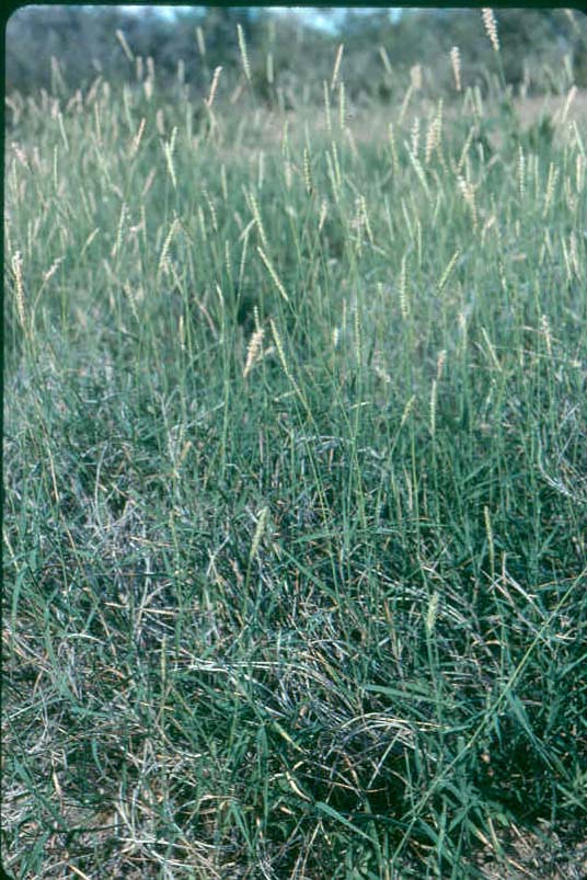
2. Trans-Pecos Basin and Range supports the driest major grassland range type in North America, the semidesert grassland. This remarkable grazing type consist of two major forms: 1) bottomland-like sites such as this swale which is dominated by tobosagrass with cholla and soaptree yucca (Yucca elata, the State Flower of New Mexico) and 2) upland sits dominated by black grama (Bouteloua eriopoda) as seen here in the background.Hudspeth County, Texas. June. FRES No. 40 (Desert Grasslands Ecosystem). K-48 (Gramagrass-Tobosagrass Prairie). SRM 505 (Grama-Tobosa Shrub) variant. Tobosa Grass-Scrub Series 143.12 of Chihuahuan (Semidesert) Grassland biotic community 143.1 of Brown et al. (1998). Chihuahuan Deserts- Chihuahuan Desert Grasslands Ecoregion, 24b (Griffith et al., 2004).
3. A tobosagrass flat or swale- Clearly a consociation of tobosa. Tobosa-dominated areas of rangeland comprise one of the two major (most widespread) kinds of semidesert grassland (black grama-dominated grasslands are the other, and even, more widespread kind). The shrub by the black cow is littleleaf or desert sumac (Rhus microphylla). The ChihuahuanDesert (discussed below) is evident in the background. Clay flat range site.Dona Anna County, New Mexico. June. FRES No. 40 (Desert Grasslands Ecosystem). K-48 (Gramagrass-Tobosagrass Prairie). Not specifically described by SRM cover type; variant of SRM 505 (Grama-Tobosa Shrub). Tobosa Grass-Scrub Series 143.12 of Chihuahuan (Semidesert) Grassland biotic community 143.1 of Brown et al. (1998). Chihuahuan Deserts- Chihuahuan Basins and Playas Ecoregion, 24a (Omernik and Griffith, 2006).
4. Tobosagrass- New growth from recent rains on a properly grazed tobosagrass flat. Correct amount of residue (utilization or degree of use) under the conservative stocking that is proper for this arid and drought-prone range type. Clay flat range site, Dona Ana County, New Mexico. June.

5. Inflorescences of tobosa- Raceme-like spikes of tobosagrass in anthesis even in severe water stress of a multi-year extraordinary drought. New Mexico State University College Ranch, Dona Ana County, New Mexico. June.

6. Tobosagrass swale or flat- Appearance of a tobosagrass flat following recent heavy rains in Trans Pecos section of the Basin and Range physiographic province. Elephant Mountain Wildlife Management Area, Brewster County, Texas. July. FRES No. 40 (Desert Grasslands Ecosystem), K-48 (Gramagrass-Tobosagrass Prairie). SRM 505 (Grama-Tobosa Shrub) variant. Tobosa Grass-Scrub Series 143.12 of Chihuahuan (Semidesert) Grassland biotic community 143.1 of Brown et al. (1998). The mesic form of semidesert or desert plains grassland. Clay Flat range site.

7. Tobosagrass sward in anthesis- Local population of tobosagrass in peak bloom following recent rains. The conspicuous forb was devil's claw or unicorn plant (Proboscidea parviflora). Elephant Mountain Wildlife Management Area, Brewster County, Texas. July. FRES No. 40 (Desert Grasslands Ecosystem). K-48 (Gramagrass-Tobosagrass Prairie). Clay Flat range site.

8. Devil in the desert grassland- Plant of devil's claw or unicorn plant (Proboscidea parviflora= P. louisianica= Martynia louisianica) with both flowers and fruit. Devils' claw has been included in the the sesame family, Pedaliaceae (Great Plains Flora Association, 1986, p. 803; Diggs et al., 1999, ps. 879-880), or its own unicorn plant family, Martyniaceae (Steyermark, 1963, p. 1372). Devil's claw is a widely distributed plant being found growing naturally from Texas and Mexico westward to the Mojave and Sonoran Deserts of California. In addition, unicorn plant has naturalized widely across North America being found from Pennsylvania to Louisiana which might (or might not) be part of its original species range. Unicorn plant conceivably could have spread perhaps due to cultivation for its fruits which are used as a type of pickle (all the above sources made note of this fact).
Devil's claw does best on drought to xeric habitats. This individual shown here was growing in the West Cross Timbers of northcentral Texas in the worst one-year droughts on record.
College Farm, Tarleton State university, Erath County, Texas. Late September; full-flowering to fruit-set stages.


9. Devilish details- Devil/'s claw or unicorn plant shown with flowers, leaves, current year's fruit and last year's fruit (first slide). Details of the unusually colored flower with a backdrop of its leaves were presented in the second slide. Plants of this species are typically annuals though some individuals are short-lived perennials. This plant had been grazed (lightly in this case) by white-tailed deer (Odocoileus virginianus). In a summer of Exceptional Drought (Palmer Severity Index rating of D4) deer had grazed most devil's claw plants on this range into oblivion. This and two other plants were the only ones of dozens that the author found to left to photographed (damn deer getting in the way of education).
College Farm, Tarleton State university, Erath County, Texas. Late September; full-flowering to fruit-set stages.

10. Last year's and this year's crop- The picturesque fruit of devil's claw or unicorn plant. Green (immature though ripening) fruit at left accompanied by a dried and split-open fruit from the preceding year at right. This fruit was described in detail by the Great Plains Flora Association (1986, p. 803) as "…drupaceous capsule, bivalved and dehiscent" T he author had had many of these dried fruits wrap around his boot heel on the New Mexico State University College Ranch, especially on desertified semidesert grassland. This fruit had been produced in the West Cross Timbers of northcentral Texas during the worst one-year drought on record.
College Farm, Tarleton State University, Erath County, Texas. Late September.
Technical note: the next five sets of paired photographs compared JPEGs made from 35mm Kodachrome slides by an Epson Perfection V700 Photo color scanner (photographs on left) and a Hewlett-Packard Scan Jet 7400C-Scan Jet XPA color scanning unit (photographs on right). Color was most accurately reproduced by the Epson Perfection V700, but this Epson unit produced (added) an unnatural "sparkle" or "frosted" appearance to the foliage which the Hewlet-Packard Scan Jet 7400C did not add. Conversely, the Hewlet-Packard unit added a bluish-tone to foliage that the Epson did not.
Conclusion: neither the Epson Perfection (perfection it most certainly is not) with its additional "shotgun-shot sparkle" nor the Hewlet-Packard Scan Jet with its added scanned bluish tinge were completely satisfactory for the task of scanning with accurte color. Likewise, both of these cheaply made, imprecise pieces of equipment automatically cropped edges of slides. The only reason that the author used these pieces of "gyp-aggo" apparatus was that they are about all that is available for scanning decades-worth of slides taken prior to introduction of digital imaging (which incidentally has myriad problems of its own as well).
Science (education, in general) alsways involves trades-offs and compromises.

11. Tobosagrass clay flat on an ecotone- A small tobosa swale situated among larger areas of ridges in a transition zone (an "overlap" area) among western Rio Grande Plains, eastern edge of Trans-Pecos Basin and Range, and marginal contact with semiarid Edwards Plateau. There has been inconsistent mapping of vegetational (= land resource) areas of Texas (Gould, 1962, ps. 1, 11; Correll and Johnston, 1979, map 1, ps. 9-10, 12), potential natural vegetation (Kuchler, 1964, map in Garrison et al., 1977), and Texas level III ecoregions (Griffith et al., 2004) with respect to western boundary of Edwards Plateau and eastern boundary of Chihuahuan Desert. This tobosagrass flat and surrounding stand of honey mesquite, huisache (Acacia farnesiana), and Texas persimmon (Diospyros texana) were on range that was included in the western Edwards Plateau by (Gould, 1962, ps. 1, 11; Correll and Johnston, 1979, map 1, ps. 9-10, 12), but in the eastern contacts of Chihuahuan Desert according to (Kuchler, 1964, map in Garrison et al., 1977) and (Griffith et al., 2004). There was not even one single plant of creosotebush (Larrea tridentata) in the range vegetation shown here so designation of this range plant community as being in the Chihuahuan Desert was not overly plausable.
The swale or clay flat supporting a consociation of tobosagrass did provide some textbook examples of this range plant community (even if it was a small parcel of grassland) that was used for instructive purposes (with qualifications duly noted). For practical illustration of the tobosagrass-dominated semidesert grassland the designations of vegetational units were consistent with those cited above. FRES No. 40 (Desert Grasslands Ecosystem). K-48 (Gramagrass-Tobosagrass Prairie). Not specifically described by SRM cover type; variant of SRM 505 (Grama-Tobosa Shrub). Tobosa Grass-Scrub Series 143.12 of Chihuahuan (Semidesert) Grassland biotic community 143.1 of Brown et al. (1998). Level III ecoregion of Texas was transition between Chihuahuan Deserts and Playas Ecoregion 24a of Chihuahuan Deserts and Semiarid Edwards Bajada Ecoregion 31b of South Texas Plains (Griffith et al., 2004).
Val Verde County, Texas. October, phenological stage of tobosa varied from anthesis through grain-ripe to grain-shatter.
12. "And the green grass grew all around, all around; and the green grass grew all around" (American folk song)- Characteristic sward of tobosagrass on a swale showing the semi-cespitose habit of this rhizomatous perennial eragrostoid grass. Individual plants of tobosagrass typically grow in close proximity to each other so as to form an open sod or turf, especially on more mesic habitats (eg. swales and larger bottomland sites), so that stands of tobosa have a bunchgrass-like appearance. This is in contrast to the "kissin' cousin", curly mesquite (H. belangeri), which is stoloniferous and forms a more nearly closed turf or complete sod.
This small stand or consociation had been lightly grazed by cattle such that individual plants and the open sod or turf were more obvious. These photographs were "picture perfect" examples of proper degree of use, which in the semiaridity or aridity of this range environment was on the light side of moderate. This range professor reminded his student readers that moderate grazing (= defoliation) is not automatically synonymous with proper grazing any more than is light or heavy degree of grazing defoliation proper or improper. Proper use factors are not only species-specific, but even site-specific for species-specific standards or guidelines. A key diagnostic guide to proper degree of use (the first and usually the most important of the Four Cardinal Principles of Range Management) is presence of individual shoots that were ungrazed and, usually, matured to flowering and grain production. Reproduction of perennial grasses like tobosa is usually asexual (by tillers and rhizomes in H. mutica) so seed production is not necessary nor usually important for regeneration of this valuable climax species (decreaser on swale sites). Rather, presence of sexually reproductive shoots is a very good sign to graziers that the tobosagrass range was properly managed as to degree of use. Plus, this degree of grazing defoliation with subsequent seed-set best provided for the option of establishment of seedlings that can fill in interspaces among existing tufts of older plants. Seedling establishment permitted presence of new genotypes (the opportunity for on-going genetic adaptation) of this remarkable and valuable semidesert species.
Val Verde County, Texas. October, phenological stage of tobosa varied from anthesis through grain-ripe to grain-shatter. FRES No. 40 (Desert Grasslands Ecosystem). K-48 (Gramagrass-Tobosagrass Prairie). Not specifically described by SRM cover type; variant of SRM 505 (Grama-Tobosa Shrub). Tobosa Grass-Scrub Series 143.12 of Chihuahuan (Semidesert) Grassland biotic community 143.1 of Brown et al. (1998). Level III ecoregion of Texas was transition between Chihuahuan Deserts and Playas Ecoregion 24a of Chihuahuan Deserts and Semiarid Edwards Bajada Ecoregion 31b of South Texas Plains (Griffith et al., 2004).
13. Beautiful, and outstanding example to boot- Individual plant of tobosagrass that was grazed during current growing season to proper degree of use as determined by general qualitative appearance, but not on specific quantitative guidelines (assuming that such even exist). Key features of proper grazing included: 1) adequate photosynthetic tissue (both leaves and culms) remaining following grazing, 2) some shoots that were permitted to mature to sexually reproductive (= flowering) stage, 3) irregular, domed shape of grazed plant rather than a heavily cropped one having a flat, highly hedged appearance, and 4) overall degree of utilization (composite of defoliation for whole plant) that was somewhat on light (conservative) side of the total or maximum utilization that would enable the plant to survive. In regards feature #4, management of this tobosagrass range was such that some "surplus" feed was left for an emergency, risk, etc. that might befall plant, animal, or ranching firm. The conservative or cautious grazing use would come closer to permitting higher levels of herbage production under environment stress, especially drought. The rangeman responsible for husbandry of this range had hedged his bets and left "a little extra" grass just in case "things get tight". Such wise stewartship is good ranch as well as good range management.
The rest of the explanation for the bountiful flowering of tobosa on this range as shown in these photographs was an extremely wet late summer and early autumn. Numerous, well-spaced showers and cool temperatures resulted in near ideal soil moisture conditions. Students take note: even abundant rainfall and other features of a fabulous plant-growing environment would not have permitted the profuse flowering and lush foliage of this tobosagrass had it been grubbed to the ground by overuse. Vice versa, even if growing conditions had been adverse for tobosa on this swale there would still have been some sexual reproduction in the stand given the wise use management--especially proper degree of utilization--it received.
Val Verde County, Texas. October, phenology ranged from anthesis to grain-shatter stages.
14. Nothing much purtier to a desert grassman- A large speciment of tobosagrass at peak bloom on a swale in Rio Grande Plains savanna-Chihuahuan Desert ecotone. This plant had been properly grazed (defoliation of outer edge of grass still evident in foreground) and, with blessings of late-growing season rain showers, a high number of shoots had developed to sexual maturity.
Val Verde County, Texas. October. On this one plant phenological stage varied from anthesis through grain-ripe to grain-shatter (with more soil water from each new shower ever more shoots advanced to flowering stage).

15. Anthesis in tobosagrass- The inflorescence type in this eragrostoid grass is interperted as a spike because spikelets are sessile on the rachis (Hitchcock and Chase, 1950, p.485). Gould (1975, p. 366) described the Hilaria inflorescence as a bilateral spike. Of these three spikelets only the center one is fertile (usually one-flowered) with two outer (lateral ) spikelets being staminate. The bifid anthers were visible in this "sexy" portrait of one of the dominant decreaser grasses on more mesic range sites in the semidesert grassland, Chihuahuan Desert, semiarid Edwards Plateau, and Rio Grande Tamulipan thornscrub savanna.Val Verde County, Texas. October.
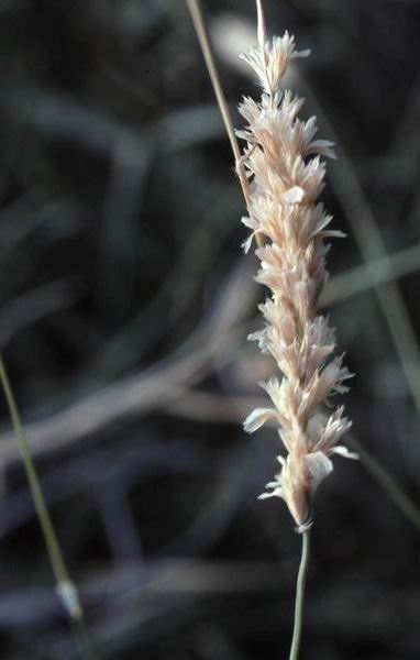
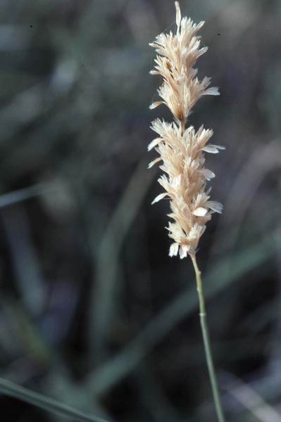
16. Grain ripe and shattering in tobosagrass- Spikelets on spikes of Hilaria spceies are in units of three with the entire three -spikelet structure or unit being designated a fascicle which falls entire (together) from the spike (as if the fascicle was one spikelet). Numerous fascicles were present and readily seen on both of the spikes shown in these slides. Val Verde County, Texas. On a swale situated among converging ridges. October.

17. Ring muhly or ringgrass (Muhlenbergia torreyi)- This cespitose grass grows on plains and mesa grasslands of the Great Plains through the semidesert plains grasslands of the Trans Pecos Basin and Range province. As indicated by it's common name ring muhly exhibits a unique growth habit. This bunchgrass produces secondary shoots only in the form of tillers such that asexual reproduction takes place around edges of the existing mother plant. The result is an ever-expanding circular pattern of growth. When the oldest tillers (mother and first daughter shoots) that were in the center of the plant were shed (ollowing their senescence and death) the result was a "ring" of tillers. Ring muhly shoots often have characteristically curled leaves.
Ring muhly is a common but not a major forage-producing species. It is, however, often readily taken by livestock. Ringgrass is undoubtedly valuable for erosion control and watershed protection. It's growth pattern was an apt illustration of the concept of clonal organism.

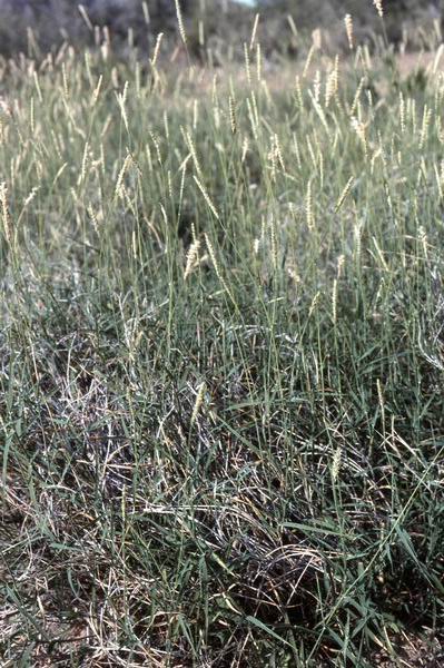
18. Desert holly (Perezia nana)- There are more species of range forbs in the Compositae (=Asteraceae) than in any other family. Composites are unusually plentiful on grassland. They are probably least common on the semidesert grassland, the most xeric of North American grasslands.One composite growing on the tobosagrass swales of semidesert grassland is desert holly. It is an indicator species of the less xeric environment on which tobosagrass range developed. It is also a diagnostic species whose presence indicates semidesert grassland, or former semidesert grassland if the present vegetation is Chihuahuan Deseertscrub (Dick-Peddie, 1993, ps. 131-132). New Mexico State University College Ranch, Dona Anna County, New Mexico. June.


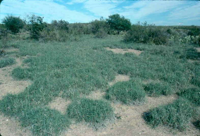
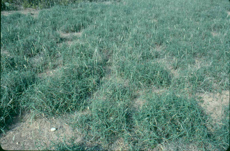
19. No, its not particularly inviting-- Views of an immense (perhaps as much as three to four thousand acres) clay flat semidesert grassland vegetated almost exclusively by tobosagrass. Shoots in this consociation were those of the preceding summer growing season with this climax perennial grass still in the dormant stage just prior to onset (hopefully) of summer rains.
About the only botanical diversity in this natural "field" (single species-stand) that had been--though not currently being--grazed by cow-calf pairs was a bare patch of soil that was "ground zero" of a colony of red harvester ants (Pogonomyrmex barbatus). This harvester ant-created microsite was visible in left midground of the third photograph in this three-slide series as well as in the second slide of the next set and the feature of the subsequent one-slide photographic lesson.
No, it did not take long to to describe climax vegetation of this cattle range.
Hildago County, New Mexico. Late June, but still vernal aspect and basically dormant to very early new shoot growth stage of phenology. FRES No. 40 (Desert Grasslands Ecosystem). K-48 (Gramagrass-Tobosagrass Prairie). Not specifically described by SRM cover type; variant of SRM 505 (Grama-Tobosa Shrub). Tobosa Grass-Scrub Series 143.12 of Chihuahuan (Semidesert) Grassland biotic community 143.1 of Brown et al. (1998). Clayey range site (Natural Resources Conservation Service, on-line, undated). Madrean Archipelago- Apachian Valleys and Low Hills Ecoregion 79a (Griffith et al., 2006).


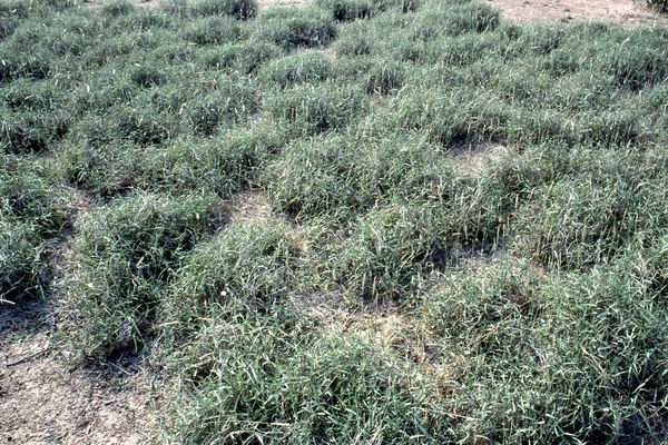
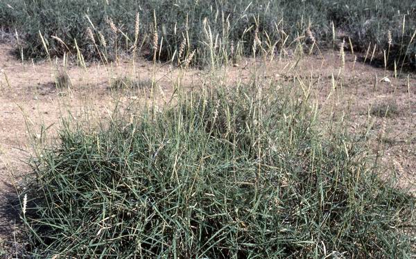
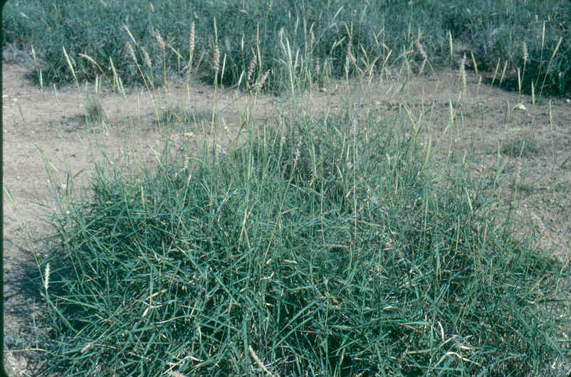
20. Yep, that's its color in early summer- Views of a consociation (a climax association of one--or,at least, dominated by one--species) of tobosagrass on the upper portion of a floodplain of the Animas Valley, part of the semidesert grassland vegettion in southwestern New Mexico. This grassland was on land known by locals as a "clay flat".
Along with black grama uplands, tobosagrass (tobosa) flats or tobosagrass (tobosa) swales, as they have long been named and known, are the major forms (range cover types) of semidesert grassland. "Sacaton flats" (consociations of Sporobolus aeroides or S. wrightii) are a third major floodplain cover type in southern parts of the Basin and Range physiographic province. Sacaton flats are considerably more restricted in area. At least this was the case in the virgin vegetation before human disturbances such as overgrazing, commerce and transportation, tillage, and military activities and, perhaps, climatic changes resulted in desertification of semidesert grasslands (in this area of southern New Mexico and Trans-Pecos Texas desertification included brush invasion as expansion of the Chihuahuan Desert).
Images presented here and in examples below were of climax tobosagrass swales. These were examples of the tobosagrass consociation form of semidesert grassland, the potential natural vegetation for comparatively "heavy clay" and relatively "light-salt" (low saline-content) soils. Tobosagrass flats are an edaphic climax. Role of animal grazing (livestock or wildlife, both prehistoric and pre-whiteman) remained unknown, but some zootic impact could not be ruled out.
On some lowland range sites tobosagrass is an increaser to such species as the climax, decreaser sacatons but tobosagrass clay flats do not constitute such range sites. In previous range site descriptions such as the Hildago County Soil Survey (Soil Conservation Service, 1973, p. 54) it was implied that tobosagrass was an increaser rather than the climax dominant whereas black grama, vine mesquite (Panicum obtusum), blue grama (Bouteloua gracilis), and sideoats grama (B. curtipendula) were the potential natural dominants (decreasers). This meantthat high cover of tobosagrass and a comparatively high percentage of herbaceous biomass of tobosa was indicative of departure from climax (Soil Conservation Service, 1973, p. 54). Such was (is) not the case on range sites having (determined by) high clay content soils.
In an interesting development, the Natural Resources Conservation Service (on-line, undated) recognized tobosagrass as the historic climax vegetation of the Clayey ecological site in stark contrast to earlier range site descriptions of Clayey range sites such as those described in the Hildago County Soil Survey (Soil Conservation Service, 1973, p. 54) that listed black grama, blue grama, and sideoats grama. The recent ecological site description (Natural Resources Conservation Service, on-line, undated) stated: "We were not able to locate areas on clayey soils that contained black grama". The newer site description did not refer to blue grama, sideoats grama, or vine mesquite. Inclusion of those species in earlier site descriptions was so "far-out" and "off-base" that the NRCS wisely chose to let such preposterous descriptions fade into oblivion. Even more interesting was the fact that whereas earlier site descriptions (Soil Conservation Service, 1973, p. 54) listed burrograss (Scleropogon brevifolius) as an either an increaser or an invader (depending on which Clayey site), the recent site description (Natural Resources Conservation Service, on-line, undated) included burrowgrass as part of the tobosa-dominated historic climax range plant community.
In published Society for Range Management rangeland cover types (Shiflet, 1994) the tobosagrass range type was "lumped" together--and, incorrectly, this author hastened to point out--with the black grama-dominated grassland type as a so-called "grama-tobosa-shrub", SRM 505, cover type (Shiflet, 1994, ps.). This described/numbered unit amounted to an "umbrella" or "super" (adjectives used by this author for lack of better descriptive terms) cover type. The SRM grass-shrub designation was incorrect on two main accounts: 1) tobosagrass swales (usually clay-based soils) are distinctly different and spatially separated from black grama uplands (typically larger-textured soils, especially loams) and 2) these two distinctly different climax communities are the two major forms semidesert grasslands and not grass-shrub savannahs. In this latter regard, these two climax semidesert grasslands, which are especially prominent in eastern portions of the Basin and Range physiographic province, characteristically have shrubs of such limited cover and density that this potential natural vegetation is undisputedly (and widely recognized) as being of the grassland biome and not climax savannah or even having a savanna physiogonomy.
Note absence of any woody plants on this cattle range (cattle were absent at time of photographs, but cattle dung attested to their recent presence) and on the cow/calf range presented below. Following that second tobosagrass swqle cattle range, a third example was presented in which there was a very sparse cover of shrubs. None of these examples of this climax range plant community (semidesert grassland) even approached a grass-shrub vegetation. This range community was, as indicated by Kuchler (1964), a variant form Gramagrass-Tobosagrass Prairie. Potential natural vegetation wasgrassland not savanna.
Hildago County, New Mexico. Late June, but still vernal aspect and basically dormant to very early new shoot growth stage of phenology. FRES No. 40 (Desert Grasslands Ecosystem). K-48 (Gramagrass-Tobosagrass Prairie). Not specifically described by SRM cover type; variant of SRM 505 (Grama-Tobosa Shrub). Tobosa Grass-Scrub Series 143.12 of Chihuahuan (Semidesert) Grassland biotic community 143.1 of Brown et al. (1998). Clayey range site (Natural Resources Conservation Service, on-line, undated). Madrean Archipelago- Apachian Valleys and Low Hills Ecoregion 79a (Griffith et al., 2006).

21. Insect herbivory was locally decisive- Land surface and local disturbance vegetation immediately surrounding a colony of red harvester ants (Pogonomyrmex barbatus) on the tobosagrass clay flat featured in the two immediately preceding slide sets. The forbs were an arid ecotype of horseweed or mare's tail (Conyza canadensis), one of the most widely distributed annual, pioneering composites in North America. The "ant bed" was in effect an old field or "go-back land" with secondary or old field plant succession in full-swing.
Hildago County, New Mexico. Late June, but still vernal aspect and basically dormant to very early new shoot growth stage of phenology. FRES No. 40 (Desert Grasslands Ecosystem). K-48 (Gramagrass-Tobosagrass Prairie). Not specifically described by SRM cover type; variant of SRM 505 (Grama-Tobosa Shrub). Tobosa Grass-Scrub Series 143.12 of Chihuahuan (Semidesert) Grassland biotic community 143.1 of Brown et al. (1998). Clayey range site (Natural Resources Conservation Service, on-line, undated). Madrean Archipelago- Apachian Valleys and Low Hills Ecoregion 79a (Griffith et al., 2006).


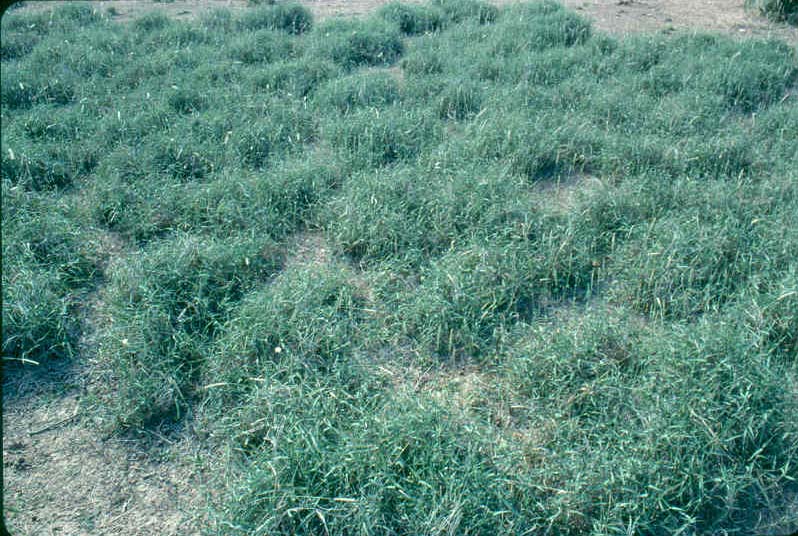
22. Cattle on a tobosagrass clay flat- Cow-calf pairs grazing a clay flat populated almost exclusively by tobosagrass, hence another nammonly descriptive tern of tobosagrass flat. It was not known if the bare soil surface was a natural feature of this particular area or if spaces devoid of vegetation were local disturbances induced by past overuse/overgrazing. Current stocking rate was not excessive and, in fact, had areas of under-utilized tobosagrass forage. Unlike dormant shoots of such eragrostoid species as black grama (Bouteloua eriopoda), blue grama (Bouteloua gracilis) and buffalograss (Buchloe dactyloides), dead tops of tobosagrass are highly unpalatable and of generally low forage quality.
Hildago County, New Mexico. Late June, but still vernal aspect and basically dormant to very early new shoot growth stage of phenology. FRES No. 40 (Desert Grasslands Ecosystem). K-48 (Gramagrass-Tobosagrass Prairie). Not specifically described by SRM cover type; variant of SRM 505 (Grama-Tobosa Shrub). Tobosa Grass-Scrub Series 143.12 of Chihuahuan (Semidesert) Grassland biotic community 143.1 of Brown et al. (1998). Clayey range site (Natural Resources Conservation Service, on-line, undated). Madrean Archipelago- Apachian Valleys and Low Hills Ecoregion 79a (Griffith et al., 2006).

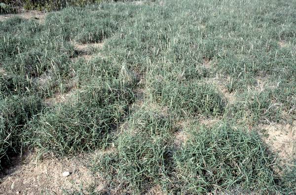
23. Another tobosagrass clay flat- This currently ungrazed (by livestock) cattle range in southwestern New Mexico served as another example of a tobosagrass swale or tobosagrass clay flat. The shrubs seen here were Mormon tea (Ephedra trifurca). An occasional small plant of honey mesquite was also present, but it was not known if this cover and density of mesquite was natural (given the small size and, presumedly, young age this mesquite presence was undoubtedly of recent origin) or, alternatively, was a brush invasion (due perhaps to fire exclusion in more recent times).
Mormon tea and soaptree yucca are unquestionably woody components of the climax tobosagrass form of semidesert grassland. By the way, note that the cover of shrubs was of such sparce (limited) dispersion that this Basin and Range vegetation did not even faintly approach a savanna, the Grama-Tobosa Shrub, SRM 505, rangeland cover type designation presented in Shiflet (1994). This was clearly grassland. The Kuchler (1964) designation of Gramagrass-Tobosagrass Prairie, K-48, was correct.
Luna County, New Mexico. Late June, but still vernal aspect and basically dormant to very early new shoot growth stage of phenology. FRES No. 40 (Desert Grasslands Ecosystem). K-48 (Gramagrass-Tobosagrass Prairie). Not specifically described by SRM cover type; variant of SRM 505 (Grama-Tobosa Shrub). Tobosa Grass-Scrub Series 143.12 of Chihuahuan (Semidesert) Grassland biotic community 143.1 of Brown et al. (1998). Clayey range site (Natural Resources Conservation Service, on-line, undated). Madrean Archipelago- Apachian Valleys and Low Hills Ecoregion 79a (Griffith et al., 2006).


24. Dormant specimens- General habit and morphology of ungrazed ungrazed adult plants of tobosagrass growing on a clay flat in the Chihuhuan Region in southwestern New Mexico. Sideview of two mature plants of tobosagrass (first slide), back-to-back position of three mature plants of tobosagrass (second slide), and topdown view of one adult tobosagrass plant (third slide). These plants were at first stage of growing season green-up with most green plant tissue on last years shoots. (This was presented in greater detail in immediately subsequent slides.)
Individual plants of tobosa have a tufted, clumped habit and are more or less cespitose in general appearance (ie. tobosa is a bunchgrass species) even though it does have short rhizomes. Frequently tobosagrass plants grow so close together that dense populations on clay flats and other floodplains that turf of this bunchgrass has the appearance of a dense sod.
Hildago County, New Mexico. Late June and--except for slight activity of some shoots--still primarily in dormant stage of phenology.


25. Tobosa closer- Two progressively closer-in views of tobosagrass at onset of summer green-up. First slide showed herbage of last year's shoots (tillers) with "tinges' of chlorophyllous tissue while the second slide revealed individual tillers that developed in the previous year (growing season) that had emerged from dormancy. These "re-activated" (rejuvinated) tillers provided amble evidence that some herbaceous shoots persist (remain alive) for more than one growing season. Such shoots are perennial rather than strictly annual organs.
Hildago County, New Mexico. Late June and--except for slight activity of some shoots--still primarily in dormant stage of phenology.


26 Rproductive and perennial- Previous year's shoots of tobosagrass with resumption of growth in early part of the current (next) year as evidenced by patches of pigmentation by chlorophyll. Tillers of tobosagrass frequently are horizontal so as to appear as stolons. This situation was evident in the right foreground of the first slide At closer camera distance of the second slide green-up of already developed, pre-existing tillers from the preceding year was more evident.
The phenomenon of perennial herbaceous shoots is an obvious adaptation to sparse--typically low and infrequent quantities of-- precipitation.
Most reproduction in tobosagrass is asexual by production of tillers from rootcrowns and short rhizomes. Developemnt of new genotypes via grain production (sexual reproduction) is a much less exercised option in this drought-adapted bunchgrass. Nonetheless, tobosagrass does produce caryopses, often abundantly. Grain production by tobosagrass was shown above at anthesis and at mature, grain-shatter stage in the next slide...
Hildago County, New Mexico. Late June and--except for slight activity of some shoots--still primarily in dormant stage of phenology.


27. Gone plum sexual- Sexual shoot with inflorescence, that is regarded as a spike, to tthe left of lower portions of three tillers (first slide) and one spike with shedding fascicles (second slide). Fascicle was defined under preceding slide-captions of tobosagrass spikes.
Chaves County, New Mexico. Late June; grain-ripe phenological stage.
28. Black grama-dominated grassland grazed continuously but conservatively for years- In early days of Anglo ranching, black grama grasslands like this were mowed for hay. Amazing what the range will produce given the chance. The research-rich New Mexico State University College Ranch, Dona Anna County, New Mexico. June. FRES No. 40 (Desert Grasslands Ecosystem). K-48 (Gramagrass-Tobosagrass Prairie). No specific SRM designation for this quintessential semidesert grassland! Grama Grass-Scrub Series 143.11 of Chihuahuan (Semidesert) Grassland biotic community of Brown et al. (1998, p. 40). Chihuahuan Deserts- Chihuahuan Basins and Playas Ecoregion, 24a (Omernik and Griffith, 2006).
29. Pristine semidesert grassland- Featured here was a consociation of black grama. While essentially a "pure stand" there were some "stray" plants of other grama species including bue grama (Bouteloua gracilis) and sideoats grama (B. curtipendula) as well as soaptree yucca which contributed an arborescent feature to this beautiful range. This is the most widespread form or kind of semidesert grassland. It provided the foundation of early day ranching throughout much of the greater semiarid to arid Chihuahuan-Sonoran Desert Region. This range was part of the famous range at White Oaks in Lincoln County, New Mexico. History and cowboy buffs will recall Billy the Kid and the Lincoln County Range War. (I see why they fought for it.) FRES No. 40 (Desert Grasslands Ecosystem). K-48 (Gramagrass-Tobosagrass Prairie). K- 48 (Grama-Tobosa Prairie). Note that Kuchler (1964, in Garrison et al., 1977) did not separate black grama- from tobosa- grassland. There is no specific SRM cover type desciption for the "pure form" of black grama semidesert grassland; SRM 505 (Grama-Tobosa Shrub) probably comes closest. Grama Grass-Scrub Series 143.11 of Chihuahuan (Semidesert) Grassland biotic community of Brown et al. (1998, p. 40). Chihuahuan Deserts- Chihuahuan Desert Grasslands Ecoregion, 24b (Omernik and Griffith, 2006).
30. Quintessence of semidesert grassland- The next four photographs portrayed the ultimate expression of black grama-dominated Basin and Range "desert grassland". Magnificant ranges like the one shown here were what made the Trans-Pecos Region famous as "cow country". This range vetetation was on a marvelously managed cattle range (private property) one growing season after the severe to extraordinary drought of the 1990s through early to mid 2000s (the Long Drought).

30A. Black grama semidesert grassland in "mint condition"- With proper management-- in this case, limited to proper grazing management--even after a decade or more of severe drouth this vegetation was still as virgin as it gets. Species composition, community structure, and ecosystem function was the same as if human eyes had never rested on it. This was almost a single grass species-community with sparsely scattered evergreen shrubs. There were also scattered individual plants of sideoats grama (like the larger cexpitose grass plant in center foreground) and cane bluestem. Tobosagrass grew on the isolated microsites of small depressions in the land surface.
Students were again reminded that black grama semidesert grassland is by far the most common kind or form of what has traditionally been called "desert grassland. Black grama is the regional or zonal dominant grass of the greater Chihuahuan-Sonoran Deserts Basin and Range Region.
Presidio County, Texas. June, early estival aspect prior to onset of summer rains. FRES No. 40 (Desert Grasslands Ecosystem). K-48 (Grama-Tobosa Prairie). SRM 505 (Grama-Tobosa Shrub). Grama Grass-Scrub Series 143.11 of Chihuahuan (Semidesert) Grassland biotic community of Brown et al. (1998, p. 40). Chihuahuan Deserts- Chihuahuan Desert Grasslands Ecoregion, 24 b (Griffith et al., 2004).

30B. Species diversity on "perfect" black grama semidesert grassland- Species diversity on the black grama form or expression of semidesert grassland is typically very low. It is a classic Clementsian consociation across vast areas. Other grass (and a few forb) species are present, but in small to almost trace amounts. Two of the more frequent of associate grass species include sideoats grama--State Grass of Texas--, which was conspicouosly dominant locally in the foreground, and cane bluestem, the conspicuous, somewhat decumbent grass with larger shoots in center midground. Both sideoats and cane bluestem are mid-grasss species (in contrast to shortgrass species like black, hairy, and blue grama). Given presence of both mid- and shortgrasses this range vegetation could be described precisely as "mixed prairie", but that designation as a proper title has usually been reserved for Great Plains grassland communities that also often include tallgrass species. Kuchler (1964, in Garrison et al., 1977) entitled this range type "prairie". It fits.
"Savannah" would be another arbitrary distinction that could be used to describe this range vegetation, specifically to characterize for instructive purposes presence of woody plants (the larger of which have a tree-like form). In this author's judgment, semidesert grassland is-- as historically described by the word "grassland"-- a true grassland (ie. vegetation and a range cover type in the grassland biome). Dick-Peddie (1993, p. 107) cited other workers who described this vegetation as a "shrub-steppe" . It is important for those new to this range vegetation to understand that presence of the soaptree yucca so prominent in this photograph and longleaf joint-fir or longleaf Mormon tea (Ephedra trifurca) are indicator and defining species to climax black grama semidesert grassland. Dick- Peddie (1993, ps.116 ) carefully explained this key floristic feature. That key botanical phenomenon was underscored here and now by the current author as well.
Presidio, County, Texas, early estival aspect prior to convectional summer rains. FRES 40 (Desert Grasslands Ecosystem). K-48 (Grama-Tobosa Prairie). SRM 505 (Grama-Tobosa Shrub). Grama Grass-Scrub Series 143.11 of Chihuahuan (Semidesert) Grassland biotic community of Brown et al. (1998, p. 40). Chihuahuan Deserts- Chihuahuan Desert Grasslands Ecoregion, 24b (Griffith et al., 2004).

30C. Black grama-dominated semidesert prairie- Soaptree yucca, State Flower of New Mexico, is an indicator of climax semidesert grassland of the black grama form (Dick-Peddie, 1993, ps. 131-132) and presents a savanna-like physiogonomy to this wonderfully adapted range vegetation. The semi-open sward seen in this and the next photograph is also a obvious physionomic characteristic of semidesert grassland, especially of the black grama form. As shown in photographs below, black grama, like tobosagrass, spreads (often vigerously and extensively) by stolons. The semiaridity of climate and xeric nature of soils is such that the soil surface is not covered to the extent that it is in more mesic areas and with other stoloniferous species like buffalograss (Buchloe dactyloides) or even the larger rhizomatous bunchgrasses. Buffalograss, blue grama, bush muhly, mesa dropseed, and perennial threeawns are typically present even on virgin state black grama range like this one, but their overall density and cover is miniscule other than at microsite scale. A high percentage of these grass species (eg. bush muhly, mesa dropseed, and threeawns) are strictly cespitose and produce no stolons.
Presidio County, Texas. June, early estival aspect (prior to summer rains necessary for meaningful "green-up"). FRES No. 40 (Desert Grasslands Ecosytem). K-48 (Grama-Tobosa Prairie). SRM 505 (Grama-Tobosa Shrub). Grama Grass-Scrub Series 143.11 of Chihuahuan (Semidesert) Grassland biotic community of Brown et al. (1998, p. 40). Chihuahuan Deserts- Chihuahuan Desert Grasslands Ecoregion, 24b (Griffith et al., 2004).

30D. Overall appearance of black grama-dominated semidesert grassland range- This climax vegetation illustrated physiogonomy and botanical compostion produced by presence of both herbacesou and woody species. In addition to soaptree yucca, longleaf Mormon tea or joint-fir was prsent in this slide. The herbaceous layer was "pure" black grama and the sward had the patchy or spotty appearance produced by this species. (Even though black grama reproduces to large degree via stolons this species still creates a semi-open herbaceous canopy.)
Dick Peddie (1993, ps. 116, 131-132) explained that presence of certain diagonostic (= indicator) species on what was Chihuahuan Desertscrub provided evidence that the vegetation had been semidesert grassland which had most likely been converted to desert by human-induced shifts in vegetation. Indicator species included longleaf Mormon tea (in contrast Torrey Mormon tea [Ephedra torreyana]), desert holly, and fluffgrass (Triens pulchellus). Presence of both soaptree yucca and Mormon tea added another layer to this range plant community and resulted in rang vegetation that had a savanna-like appearance and a shrub-steppe physiogonomy. These evergreen, narrow-leaved shrubs also produced a unique visual aspect to the vegetation.
Presidio County, Texas. June, early estival aspect (prior to onset of summer rainy season). FRES No.40 (Desert Grasslands Ecosystem). K-48 (Grama-Tobosa Prairie). SRM 505 (Grama-Tobosa Shrub). Grama Grass-Scrub Series 143.11 of Chihuahuan (Semidesert) Grassland biotic community of Brown et al. (1998, p. 40). Chihuahuan Deserts- Chihuahuan Desert Grasslands Ecoregion, 24b (Griffith et al., 2004).

31. Sward of black grama (Bouteloua eriopoda) - Outward physical appearance of a sample of a stand (= a colony might be more appropriate) of black grama. On a lightly grazed (by cattle) range that was in Excellent range condition class at the end of first growing season following the Long Drought of the 1990s through early 2000s. Many of the eragrostoid (= chloroid) grass species (those in Gramineae subfamily, Eragrostoideae) have shoots that live for more than one growing season (ie. have aboveground living tissue that persists for two or more years). This is not to be confused with the biennial life cycle (they are perennial species) or with semi-woody (either suffrutescent or becoming woody) plants. Rather, some shoots of some of these grasses under certain growing conditions simply do not die completely and instead maintain some meristematic tissue in culms or buds. Plants of certain grass species enter (or persist) into a condition that might be described as "semi-dormancy" from which they are able to emerge and (or in which they) "green-up" (ie. produce new tissue that is soon capable of photosynthetsis). This is undoubtedly an evolved opportunistic adaptation for survival under sporadic growing conditions such as aridity, periodic heavy precipitation, widely fluctuating temperatures, etc.
Plants in such a state of "suspended perenniality" (to coin a purely descriptively instructive term) not only respond quickly to episodes that are favorable for growth and/or reproduction, they also retain biomass of higher nutritive value (in contrast to the nutritionally leached herbage of plants and species that do not maintan such tissue and instead "die back to the ground" at the end of each growing period. This is a major reason why available herbage of most panicoid grasses like Andropogon, Bothriochloa, Panicum, and Paspalum species is less nutritions and palatable than that of of some eragrostoid grasses like certain species in Bouteloua, Chloris, and Spartina. Biomass of buffalograss also falls in this latter group.
The phenomenon just described can be visually observed by the "looks sorta green" (pale or "dim" green or gray-green) color of shoots of these species (again, at least under certain conditions). This condition and coloration was readily seen in the black grama shoots shown in this slide. Even though summer rains had not commenced at time of photographing these plant there was enough residual soil moisture (from winter and spring precipitation) that lower parts of last year's shoots were still partly green. This plus new growth of this year's young shoots provided the coloration shown here. (This is another reason for using non- or low-color enhancing film or neutral film like Kodachrome.)
Students should also take note of the open appearance of black grama sward. Black grama is not a cespitose (bunchgrass) species. Instead it is stoloniferous and a sod-forming grass. Black grama reproduces asexuallly by tillers as well as stolons but the resultant growth pattern and appearance is of an open or patchy sod with substantial bare soil among dense "clumps" of a perennial grass that spreads most effectively by runners (stolons).

32. Plant of black grama or wooly grama- This "plant" of black grama consist of a larger "clump" (group of tillers) behind three smaller "clumps". The three smaller "bunches" are clones or modules ("daughter plants") produced asexually from the larger "parent" (or "mother") plant, the latter of which was almost undoubtedly a "daughter plant" from its "parent plant". Assuming that the "parent" of the "daughter plants" was itself a clone or module of a preceding parent, each of these vegetatively or asexually produced "plants" (each module) was a ramet of one genet, the original genetic (sexual) individual. This illustrated a modular organism. Only the genet, the plant produced by sexual reproduction (exchange of gametes) was a unique or "one-of-a-kind" organism. How many years, decades, or, even, centuries ago this sexually generated ancestor came into existence is known but to God.
Black grama reproduces by seed (from a caryopsis) very rarely. Prof. Ken A. Valentine spent over forty years involved in research on the Jornada Experimental Range and New Mexico State University College Ranch. Valentine (personal communication) claimed that he had never seen a single black grama seedling.
Presidio County, Texas June.

33. Shoots of black grama- Another common name for Bouteloua eriopoda is wooly grama. This basis for this descriptive name was the abundant pubescence on the internodes (hence, wooly or fuzzy stems). This pubescence and a unique shade of green color on the culms is the distinctive idenfiying feature of this regional dominant and extremely valuable range plant.
Big Bend Ranch State Park, Presidio County, Texas. June.

34. Detail of black or wooly grama shoot- Some sheaths on black grama shoots cover (enclose) almost all of the internode of the culm. While rangemen refer to the wooly "stem" of wooly grama it is actually the wooly leaf. Leaves are frequently absent or missing from portions of black grama shoots thus exposing the culm that is often a light yellow color. This alternating green and yellow color pattern was visible in the preceding slide. Interspersed with the green and yellow pattern of living shoots is the dull gray color of dead-but-still-attached shoots like the one featured in this shot. This shoot was a tiller, a vertical or upright intravaginated shoot.
Presidio County, Texas. June.

35. Black grama runners- In contrast to the tiller in the preceding photograph, a runner (stolon is the scientific term) is a horizonal extravaginated shoot. In this photograph two stolons were laying atop and across a third (though less visible) stolon. All three stolons were living, but as is often the case for shoots of this species they looked "more dead than alive". Three nodes with emerging new clones or modules (appearing as buds) were visible. Plants were just initiating new growth at onset of summer rainy period.
Presidio County, Texas. June.


36. "Throw out the life line"- True to the words of the old hymn by E.S. Ufford black grama has grown the life line for another generation of this mostly clonally reproducing mainstay of the semidesert grassland ranges. Several stolons were visible on the surface of this sandy semidesert soil. A large module or ramet was developing from the node of the foremost runner. This "daughter plant" was shown in more detail in the second slide.
Presidio County, Texas. June.


37. "Putting down roots" or "a hen and two chicks"- Two stolons from an established black grama plant have each produced a "new plant" (a module= clone= ramet). Each "daughter plant" became established (one or maybe two growing seasons prior) and was waiting for rain at beginning of the summer rainfall period. Summer is when most precipitation occurs in the climate of the Trans-Pecos Basin and Range.
New modules were developing on another stolon (to left of established ramets) to be ready for next summer's rain.To a range plant and a rangeman, "There's always next year". The asexual reproduction shown here took place during last phases or just after one of the most severe droughts in weather records. Grazing management must allow for such reproduction: "Take care of the grass and it will take care of you".
Presidio County, Texas. June.


38. Inflorescences of black or wooly grama- The infloresecence type of eragrostoid grasses (those in subfamily, Eragrostoideae) is a raceme. Spikelets are borne on pedicels on the rachis (adjective, pedicellate). That black grama produces grain was shown here; that such grain is less productive of new black grama plants was shown in preceding photographs of asexual reproduction.
Presidio County, Texas. June. (Spikelets had persisted on the rachis throughout course of winter and spring suggesting to any range-wise rangeman that there had been but scant precipitation.)
More on King of the Upland Semidesert Grasslands (and a proverbial "major player" in adjoining grasslands of the semiarid zone). In speaking of what he designated as the Desert Plains Grassland (the Aristida-Bouteloua Association) Clements (1920, p. 144) spelled it out: "No single species of this association possesses the importance shown by Bouteloua gracilis in the short-grass region. Probably Bouteloua eriopoda is to be regarded as the most dominant species of this genus …".
Ergo, the following of treatment of black grama, the dominant gramagrass of the semidesert grassland and often a co-dominant in adjacent ecotonal grasslands. In Clements' monoclimax perspective (the successional corollary to the then-prevailing theory known as the "geologic erosion cycle") black grama wouled be the dominant Bouteloua species of the regional or zonal climax. In Tansley's polylimax interpretation with numerous potential climaxes based on edaphic and topographic features, black grama would be the climax dominant over more land area within the natural land unit involved (a physiographic province perhaps).
In discussing black grama from the perspective of its being a major range plant, the U. S. Foreset Service (1940, G28) concluded that black grama "was originally the mainstay of the range on numerous areas of the Southwest".
Re-clarification: the current author interpreted the grassland (grasslands) in the eastern (Trans-Pecos) portion of the Basin and Range physiographic province and adjacent Staked Plains (Llano Estacado) of the Great Plains province on which blue grama and black grama were co-dominants as ecotonal grasslands. These grasslands formed a broad transition zone between these two physiographic provinces and, thus, were parts of a vast mosaic of potential natural (= climax) vegetation that also included edges of western conifer forests, shinnery oak (Quercus havardii) scrub, and Chihuahuan Desert.
Black grama, wooly-foot grama, or wooly-stemmed grama (Bouteloua eriopoda), regional climax dominant of southwestern grasslands:

39. Mature specimen on rocky upland- A mature plant of black grama growing on a rocky, shallow slope in an ecotonal grassland (transition zone between semiarid mixed prairie of the Staked Plains and arid semidesert grassland of the Trans-Pecos Basin and Range physiographic province. This magnificant specimen had been produced during record rainfall throughout the entire black grama-growing season. It was one for the record books, and your diligent photographer recorded this example of his viewers' education and inspiration. This cespitose habit combined with a "laying over" of upper shoots frequently results in this pronounced "bunched" or "bushy" appearance. This same habit is also common in other Bouteloua species of the arid zone such as B. ramosa and B. breviseta which are also climax dominants in other range sites and local habitats in the semidesert grasslands of the North American Southwest.
All of the standard floras or manuals across the so-called Desert Southwest Region have attested to the value of black grama as a major, dominant, prominent, etc. grass species (Coulter, 1891-1894, p. 532;, Gould, 1951, p. 150-151; Hitchcock and Chase, 1951, p. 542; Powell, 1988, ps. 215-216). Wooton and Standley (1915, p. 87) remarked: "This is one of the most valuable range grasses in southern New Mexico". Unfortunately, in many of the earlier accounts of range vegetation the name "black grama" was also applied to tobosagrass (Hilaria mutica) and bush muhly (Muhlenbergia porterii) as well as Bouteloua eriopoda (Allred and Ivey, 2012, p. 638) which to much degree exaggerated the feed value (and that would be hard to do) of the "real" black grama. Such mistakes were readily understood given that tobosagrass is the dominant--often the sole grass (a consociation)--in swale areas of semidesert grassland while bush muhly can grow in even closer association with black grama, especially on ecotones between semidesert grassland and Chihuahuan Desert scrub (personal observation of the author).
Kearney and Peeples (1960, p. 126) explained that Bouteloua was "Arizona's most important genus of forage grasses"; and, while these authors specifically mentioned B. rothrockii, B. curtipendula, B. gracilis and even species of six-week gramas, they did not make reference to B. eripoda other than to give Arizona counties of occurrence (Kearney and Peeples, 1960, p. 127-128) and note that black grama was "sparingly stoloniferous". Shreve and Wiggins (1964, p. 276) used the same words of "sparingly stoloniferous" (the latter had to have taken part of their description from the earlier work). In assessment of the current author black grama is at least "moderately" stoloniferous.
Great Plains Flora Association (1986, ps. 1141) gave the biological (species) range of black grama as being from northern Mexico northward to Kansas, Colorado, Wyoming, east to Oklahoma and west to Utah.
Strangely, Gould (1975, p. 350) made a major blunder and described black grama as often being associated with woody plants "on heavily grazed rangelands". Of course just the opposite is the case as the standard management and basic conservation guides attest: black grama is quickly lost on heavily, especially overgrazed, ranges. This was undoubted a mis-written section (and should not be held against Gould [1975]) as he quite correctly wrote (a quarter century earlier): "Although drought-resistant and ecologically well adapted in its natural range, black grama does not mainain itself well under heavy grazing pressure and tends to be eliminate on overstocked ranges" (Gould, 1951, ps. 150-151). This is an example to beginning students that you cannot proof-read your final manuscripts too many times (though authors do tend to overlook such gaffs even with repeating readings).
Brewster County, Texas. Early October; peak standing crop, grain-ripening stage of phenology.


40. A moorish red more than black- Upper shoots of a large cespitose plant (first slide) and upper sexual shoots with inflorescences (second slide) of black grama growing on a rocky, shallow south slope on ecotonal grassland in a broad transition zone between the semiarid Llano Estacado (Staked Plains) mixed prairie and arid Basin and Range semidesert grassland at eastern edge of the Marfa Basin. Neighbors to black grama included sideoats grama, blue grama, plains bristlegrass, green sprangletop, plains lovegrass, cane bluestem, Havard's threeawn, and Wright's threeawn along with whitethorn or mescat acacia and honey mesquite.
This amazing amount of herbage and the bountiful flower clusters were produced in a black grama-growing season of record-breaking rainfall(wet from spring through to early autumn)
Brewster County, Texas. Early October; grain-ripening stage of phenology.


41. Colorful, graceful, and distinctive- Upper portions of sexual shoots and inflorescences of black grama presented at progressively closer camera distance. These organs were growing on the same, large, cespitose plant presented in the immediately preceding slide. Details of habitat and botanical neighbors were given in the immediately preceding caption.
The long, graceful, generally ascendingly erect racemes with a distinctive tuft of fuzzy, white pubescence where the raceme joins the rachis provided fool-proof, definitive, nothing-else-looks-like-it identification of this "king grass" of the semidesert grassland (and frequently adjoining grasslands, arid savannahs, and desert scrub). This grass is just a downright aesthetically pleasing ("damn good lookin'") species.
These organs grew during a growing season-long period of record-setting rainfall. Black grama capitalized on such record abundance with record-like abundance of its own. (You're welcome; it was the author's pleasure to be able to share such abundance.)
Details of the Bouteloua inflorescence and its units were presented in the immediately following caption …
Brewster County, Texas. Early October; grain-ripening stage of phenology.


42. Telltale tuft and tone- Distinctive, one-of-a-kind tufts of fuzzy, white pubescence at union of raceme (or racemose spike) and rachis (or central axis of a raceme inflorescence) in black grama growing on a shallow, stoney slope at edge of the Marfa Basin in an ecotonal grassland (se captions immediately above). The individual branches or collective units of spikelets have been interpreted variously. Hitchcock and Chase (1951, p. 532) described the Bouteloua inflorescence as consisting of one to several racemose spikes on a common axsis on which one-flowered spikelets were arranged sesile in two rows along one side of the rachis. Chase (1964, ps. 57-58) described this as "sessile spikelets in one-sided spikes" that are "racemose". This entire Bouteloua inflorescence (including all one-sided spikes) is an raceme of spikes (Chase, 1964, ps. 18, 58).
In stark contrast, Barkworth e t al. (2003, p. 250) reinterpreted the Bouteloua inflorescence as a panicle of one to many solitary, spikelike branches that are one-sided with a racemose or elongate rachis and tha have one to many sessile spikelets arranged in two rows. Gould (1975, p. 335) had previously described the Bouteloua inflorescence as consisting of one to several short, spicate branches along a main axis and with spikelets arranged in two rows on these spicte branches. Shaw (2012, p. 334) followed his mentor and used the identical words in describing the Bouteloua inflorescence. These two authorities of Texas grasses did not specify the overall inflorescence type (eg. raceme or panicle), nor did their predecessor Silveus (1933). In yet another turn of controversey (irony?), however, Correll and Johnston (1979, p. 243) in the manual of Texas vascular plants interpreted the overall Bouteloua inflorescence as a panicle of spikes which pre-saged the interpretation in Barkworth et al. (2003, p. 250) by a quarter century. Allred and Ivey (2012, p. 625) described the inflorescence of Bouteloua as "a panicle of several evident, unbranced, spicate, primary branches".
The one thing that all these agrostologists agreeded on was that there were spikelets on some branch-looking thing that attached to a central axis, and all--except Allred and Ivey (2012; p. 625) who were mum in this regard--these were sessile spikelets arranged in two rows.
Further discussion of the Bouteloua inflorescence was given below when comparing flower clusters of black grama with those of blue grama, along with discussion of various subdivisions of genus, Bouteloua.
The tuft of short, fuzzy, grayish or whitish pubescence at the union of the racemose spike and the central axisis of the entire raceme inflorescence is unique among Bouteloua species to black grama. As characteristic--but less esclusive--is the maroon color of the spikelets aligned sessile on the rachis of the racemose spike.
Brewster County, Texas. Early October; grain-ripening stage of phenology.


43. Clonning on rocky upland- Clonal or modular units (modules) of black grama that developed at nodes on stolons of plants growing in a transition zone grassland (between Staked Plains mixed prairie and Basin and Range semidesert grassland) on a shallow, rocky slope at edge of the Marfa Basin.
Reproduction in black grama is overwhelmingly asexual with development of "sister plants" (clonal offshoots) from "parent plants" or "mother plants" which, themselves, were originally modular units or ramets. The best description of reproduction that this author could find was that of Leithead et al. (1971, P. 61) who specified that most new plant establishment (growth and development of moldules) took place at nodes on stolons and from root crown buds. Reproduction of these clonal offshoots typically required two years (two consecutive growing seasons) with the first year needed for production of stolons and the second year required for rooting and establishment of clones along stolons (Leithead et al., 1971, P. 61). These authors explained that wherereas a vigerous black grama plant could produce six to nine stolons per year, seed (grain) production was unreliable with seed viability often being low even with good grain production (Leithead et al., 1971, P. 61).
It was interesting that there is so little about reproduction/regeneration of such a valuable range plant and natural dominant species of semidesert grasslands. Information and knowledge detailed by Leithead et al. (1971, p. 61) was apparently based on their experience and "hear-say" learning. Such material was consistent with traditional observations and anecdotal observations, but there is almost no empirical researchto support such more-or-less obvious conclusions. This author was told by Prof. Ken Valentine of New Mexico State University (personal communication, 1972) that in over 40 years of working with black grama on semidesert grassland ranges in the Rio Grande Valley of southern New Mexico Valentine never could find even one black grama seedling! Obviously there had to be seedlings at one time but sexual reproduction might be on a time scale comparable to solar eclipses.
Peters (2002) compared recruitment of black grama and blue grama on a shortgrass plains grassland-Chihuahuan Desert ecotone in New Mexico and concluded that black grama was relatively short-lived (as compared to blue grama) and that replacement of black grama following plant death depended on seedling establishment "even if only at low frequencies". Whereas most recruitment of blue grama occurred through establishment of seedlings, black grama recruitment relied on both sexual reproduction (seedling establishment) and asexual or vegetative reproduction (establishment of clonal units along stolons). Caryopsis production and establishment of new plants from seed was essential for both black grama and blue grama.
Peters (2002) description of black grama plants as short-lived was based on findings by Wright and Van Dyne (1976) that life span of this stoloniferous species was 35 to 40 years. Characterization of the cespitose, tillering blue grama as long-lived came from findings by Colffin and Lauenroth (1990) that longevity of blue grama plants extended to 400 years. From such findings the inescapable rational was that seed production--as well as generation of asexual module ("daughter plants") off of stolons--is essential for continued persistence of black grama, the regional, climax, dominant (and complaratively "fragile" decreaser) of upland habitats of semidesert grassland.
Also in context of seed production in black grama was successful release of two cultivars of black grama by Soil Conservation Service Plant materials Centers: 1) "Sonora" black grama (Arizona Plant Materials Center, 1965; no longer available) and 2) "Nogal" black grama (New Mexico Plant Materials Center, 1971). Average seed yield of "Nogal" black grama at the Los Lunas (New Mexico) Plant Materials Center was 24 pounds of pure live seed per acre. Recommended seeding rates for "Nogal" were typically two or three pounds of pure live seed per acre (Natural Resources Conservation Service, 2015).
Seed dormancy can be a major impediment to prompt germination/emergence of native species, especially grasses. Black grama was found to have seed dormancy resulting from inhibition of germination by light (Wright and Baltensperger, 1964).
In essence, black grama does produce some viable/germable seed and establishment of new genotypic plants by sexual reproduction is possible. In fact, seedlings of black grama can be successful and standards for growing, collecting, and planting black grama seed were published(Natural Resources Conservation Service, 2015). Regardless, under natural conditions on semidesert grassland or grass-desert shrub savanna ranges most reproduction of black grama is asexual (self-cloning of existing genotypes) from prolific stolon production. Also of some importance in regards sexual reproduction is feeding on black grama caryopses by larvae of an apparaent obligate grain-feeding thrip species (Chirothrips falsus) as reported in central and southern New Mexico (Watts, 1965).
Further knowledge regarding seed (grain) production of black grama was given in captions below showing anthesis in black grama and with comparisons of co-dominant black grama and blue grama on swale habitats in the Marfa Basin.
Brewster County, Texas. Early October; vegetative stage (asexual reproduction).

44. Bent on rocky upland- Geniculate (beant like an elbow) shoots with characteristic wooly pubeescence on internodes of black grama growing on a shallow, stony slope at edge of the Marfa Basin in the eastern Basin and Range physiographic province.
Brewster County, Texas. Early October; vegetative growth stage.

45. Specimens on a deep swale- Several mid-sized plants of black grama growing in the banded vegetation on a loamy swale edaphic/topographic site in ecotonal grassland (transitional between semiarid Staked Plains mixed prairie and arid semidesert grassland) in the Marfa Basin of the eastern (Trans-Pecos) portion of the Basin and Range physiograaphic. These plants were photographed at peak standing crop and full anthesis only two days after and about five miles away from the examples of blakc grama presented in the immediately preceding series of slides. The specimens seen here and in the two slide/caption sets immediately below were growing on a more mesic edaphic habitat and, hence, an environment in which black grama plants had not matured (reached anthesis or grain-set) as early as those shown immediately above that grew on a more xeric site on a shallow, stony, south slope.
Shoots of these plants had grown in a growing season over the entire duration of which rainfall had been at or near record levels. This is what black grama can do under best of growing conditions in transition grassland on which black grama and blue grama were con-dominant range plant species.
Black grama is an immensely important range grass in the semidesert grasslands and certain range sites on adjoining Chihuahuan and Sonoran Deserts along with transition grassland vegetation that is ecotonal among these range plant communities and with mixed prairie. Black grama is undoubtedly a keystone species, but probably there have not been any experimental studies actually proving this rational assumption. Black grama is on both the list of 200 important range plant species for the Society for Range Management-sponsored International Range Plant Identification Contest (Stubbbendieck et al., 1992, ps. 80-81) and the Texas range plant list for various 4H and Future Farmers of America range contests (Hatch and Pluhar, 1993, ps. 60-61). One of the best overall discussions of black grama froma the standpoint of Range Management remains that of the U.S. Forest Service (1940, G28).
The situation regarding presence of black grama, the regional climax dominant over much of the semidesert grasslands, is simply that this species is so palatable and yet so weakly tolerant of heavy grazing that it was removed from much of the virgin range by overgrazing. Essentially all discussions of black grama in regards to grazing have noted this vulnerability to abusive grazing and disappearance from degraded ranges, including recent work such as Barkworth et al. (2001, p. 262) and Shaw (2012, p. 338).
Presidio County, Texas. Mid-October; anthesis to immediate post-anthesis.


46. Pollinating on a swale- Units of the inflorescence of black grama at peak anthesis on a mesic swale habitat in the Marfa Basin of the Trans-Pecos Basin and Range physiographic province.
Presidio County, Texas. Mid-October; anthesis.


47. Two kinds on a swale- Shown at three progressively closer camera distances were sexual shoots and inflorescences of black grama and blue grama that grew side-by-side in a swale on transition grassland (an ecotone between Staked Plains semiarid mixed prairie and Basin and Range arid semidesert grassland) at edge of the Marfa Basin in Trans-Pecos Texas.
Two to three individual plants of blue grama and black grama were growing in such close proximity that your author merely gathered some sexual shoots with mature inflorescences (racemes, panicles, spikes, panicles of racemose spikes, whatever these flower clusters are; see next paragraph) from plants of both species and wrapped them around each other long enough to take these and some other slides. The more elongated, narrower (= more slender or thinner), and generally smaller inflorescence branches (= racemose spikes) were those of black grama. Conversely, racemose spikes of blue grama were larger and had less prominent ends of these branches (extensions of the rachises). Spikelets on these racemose spikes (of both Bouteloua species) were in immediate post-anthesis or early grain-forming stages.
The structure of Bouteloua inflorescences and interpretations of the various structures of these flower clusters by various authorities was presented (with cited authors) above in descriptive captions under more detailed views of inflorescence units. By way of short review, some authors (Hitchcock and Chase, 1951, p. 532; Chase, 1964, ps. 18, 58) regarded this inflorescence as comprised of two to many "spikes racemose on a common axis" or of "sessile spikelets in one-sided spikes" that are "racemose" with the entire inflorescence (including all one-sided spikes) being a raceme of spikes. Silveus (1933, p. 425) also used the words "spikes racemose on a common axis". Other authors (Correll and Johnston, 1979, p. 243; Barkworth e t al. (2003, p. 250; Allred and Ivey (2012; p. 625) interpereted the overall Bouteloua inflorescence as a panicle while others (Gould, 1975, p. 335; Shaw, 2012, p. 334) fell silent as to overall form or type of Bouteloua flower cluster and were content to described the inflorescence as being comprised of one to several short, spicate branches along a main axis.
Agrostologists have long recognized differences between Bouteloua species that have inflorescences with a single (or, at most, a few) vertical floral axis with spikelets aligned laterally along this rachis from those Bouteloua species having inflorescences with raceme-resembling branches and pectinate spikelets. Hitchcock and Chase (1951, ps. 532-533) in the "bible" of United States grasses "forever" divided and arranged these two respective forms of Bouteloua species into section 1, Atherolpogon and section 2, Chondrosium. The division of Bouteloua species in Texas into Chonsrosium and Atheropogon without distinction as to taxonomic level can be traced back as far as Coulter (1891-1894, ps. 530-533). Silveus (1933, p. 425) recognized Texas Bouteloua species as falling "into two well-marked subdivisions" (for which he did not provide names): 1) those with pectinate spikelets and persitent spikes and 2) those with non-pectinate spikelets and spikes "falling entire". Gould (1975, p. 335) retained the two sections of Hitchcock and Chase (1951, p. 532-533)--unit names previously shown by Coulter (1891-1894, ps. 530-533) and un-named units described by Silveus (1933, p. 425)--renaming these sections Bouteloua and Chondrosioides. In Flora of North America Barkworth et al. (2003, ps. ps. 252-269) divided genus Bouteloua into two subgenera: 1) Bouteloua and 2) Chonsrosium based on previous (both early and recent) work, much of which was just cited.
Shaw (2012, ps. 268, 334-335) went "whole hog", "hog wild", or "ape crazy" and kept the vertical, spicate-branched, non-pectinate-spikelet Bouteloua species in genus Bouteloua, but moved the more-or-less horizontal or ascending, spicate-branched, pectinate-spikelet Bouteloua species back to genus Chondrosum. Moved back to Chondrosum because at one point in the musical chairs of Gramineae Taxonomy the "pectinated" gramagrasses had been in Chondrosum (before they were moved to Bouteloua). This was shown in the synonymy of Hitchcock and Chase (1951, ps. 827-830) and as older scientific names (eg. as Chondrosium eriopodum) in Wooton and Standley (1915, ps. 86-87).
What goes around, comes around--at least in Grass Systematics! Just hold fast to your old scientific names, colleagues; they are like neck ties and will come back in fashion sooner or later. That is some of them will. The cladists would (will?) eventually throw out the entire Linnean System and, hence, there will be two schools of taxonomic thought or two groups of taxonomic authorities probably resulting (eventually) in two different taxonomies, floras, manuals, etc. Guess which one this rangeman will be in. Remember, botanical names in the classic literature of Range Management, Grassland Ecology, Forestry, etc. were from the Linnean tradition of biological species (standards of morphology, physical separation, habitat) and not the biochemical criteria of cladistics.
"The thing that hath been, it is that which shall be; and that which is done is that which shall be done: and there is no new thing under the sun". Ecclesiastes 1:9 (KJV)
Some of the limited knowledge regarding sexual versus asexual reproduction and seed (grain) production in black grama was reviewed and cited above. For all intents and purposes, these studies and applications clearly demonstrated problems--but not impossibilities--in establishment (re-establishment) of black grama by sexual means (seed production and reseeding) versus the predominant mode of asexual reproduction via establishment of clonal units (= ramets, offshoots, or daughter units) along stolons of the highly stoloniferous black grama. In comparative studies of black grama and blue grama on semiarid grassland and shrub-grass savanna in New Mexico, Peters (2002) found that black grama produced more grain per plant than did blue grama, but that seed viability and persistence in soil was lower for black grama than for blue grama. Less physiological effort or lower resource allocation to grain production by black grama was shown by greater herbage biomass relative to grain biomass in black grama than in blue grama. On a shortgrass plains grassland-Chihuahuan Desert transition zone it appeared that recruitment of black grama was most limited by availability of viable seed (ie. a soil seedbank of germinable black grama caryopses) whereas blue grama recruitment was more limited by restricted seedling establishment (Peters, 2002).
For unknown reasons, Peters (2002) did not employ the widely used comparison of the "phalanx" form versus the "guerilla" form of clonal spread. In this vernacular, cespitose or tufted grass species (bunchgrasses or tussock grasses) like blue grama with its closely packed tillers are the "phalanx" form while sod-forming or stoloniferous grasses like black grama with its more widely spaced "daughter plants" coming off of sprawling runners are the "guerilla" species or form of modular growth (Begon et al., 1990, p. 188). Black grama versus blue grama is a textbook example of two opposite ends of this continuum. Although both black grama and blue grama had asexual or vegetative reproduction (production of offshoots, clones, or ramets), sexual reproduction (seed production) would appear to be relatively more important in the "slower moving", "phalanyx" form of blue grama. The findings of Peters (2002) lent support for this rational conclusion even though she did not invoke the concept.
Other findings and applications with regard to grain production in black grama, including other aspects from the work of Perters (2002), were presnted above in the caption for two slides that showed "daughter plants" or "sister plants" (modular units) that developed along black grama stolons growing in the Marfa Basin of Trans-Pecos Texas.
Presidio County, Texas. Mid-October; immediate post-anthesis.


48. A higher and sorta semidesert grassland- Sweeping landscape of a savanna form of semidesert grassland in the San Andres Mountains in southcentral New Mexico. The San Andres Range has been interpreted as a southern extension (more like an "island") of the Southern Rocky Mountains. Specifically, the mountain range seen in the distant backgtround was that of the San Augustin Mountains portion or subunit. These two views were in the close vicinity of San Agustin Pass (elevation 5,710 feet), a gap in the San Augustin Mountains used for passage by Indian, especially of the Jornada Mogollon culture; Spanish; Mexican; and, now, American travelers.
Range vegetation shown here was black grama-dominated semidesert grassland with sporatic to dense woody cover of the evergreen scrub white oak, Quercus turbinella, along with lesser cover of skunkbush sumac (Rhus trilobata= R. aromatica), Apache plume (Fallugia paradoxa), wait-a-minute bush or catclaw mimosa (Mimosa biuncifera), and California bricklebush or brickellbush (Brickellia californica). Although black grama was the dominant grass there was appreciable cover of blue grama, mesa dropseed, and, in more mesic microsties, sideoats grama.
The seeeping vista in the first slide was part of White sands Missile Range whereas land in the second slide was range administered by Bureau of Land Management serving as both picnic area and cattle allotment. (Cattle were not curently--at time of photograph--grazing on this allotment, but cow dung testified to their presence in the not-too-distant past. Perhaps cattle had been attracted to occasional "leftovers" of trashy picnickers.) This part of White Sands Missle Range had not been grazed by livestock for decades.
The grass component of this climax range plant community had the dominant black grama and mesa dropseed as members of drier portions of basin semidesert grassland that was conterminous below the San Andres Mountain Range with blue grama and sideoats grama from juniper woodland that developed at higher elevations in the San Andres Range. The shrub component of this semidesert grassland savanna consisted of range species that were generally more at home at higher elevations, but that had "crept down" the mountain to join the higher elevational end of semidesert grtassland. In essence, this climax range vegetation was an ecotone or transition zone between two major range cover types in this general Chihuhuan Desert Region.
White Sands Missile Range and Bureau of Land Management Aguirre Spring campground. Dona Ana County, New Mexico. Late June, early estival aspect. Semidesert grassland was FRES No. 40 (Desert Grasslands Ecosytem). K-48 (Grama-Tobosa Prairie). SRM 505 (Grama-Tobosa Shrub). Grama Grass-Scrub Series 143.11 of Chihuahuan (Semidesert) Grassland biotic community of Brown et al. (1998, p. 40). Shrubland was FRES No. 34 (Chaparral-Mountain Brush Ecosystem). K-27 (Oak-Juniper Woodland). SRM 503 (Arizona Chaparral or Arizona Interior Chaparral). Warm Temperate Scrubland 133.- Southwestern Interior (Arizona) Chaparral 133.3- Scrub Oak Series 133.31 of Brown et al. (1998, .p. 39). Note: this was a more mesic variant of these vegetational units as, for example, these were shrubs that were more typically foothill species which replaced basin desert shrubs like the dominant creosotebush (Larrea tridentata). Chihuahuan Deserts- Low Mountains and Bajadas Ecoregion 24c (Griffith et al, 2006).

49. Semidesert savanna- In foothills of the San Andres Mountains a semidesert grassland savanna had developed with the dominant black grama "accompanied" by blue grama, mesa dropseed, and, in the most favorable microhabitats, sideoats grama with widespread groups or aggregations (mottes would be an appropriate vegetational term) of woody shrubs, especially the evergreen scrub oak, Quercus turbinella, along with skunkbush sumac, catclaw mimosa or wait-a-minute bush, Apache bush, and California bickllebush.
This ecotonal grassland was a transition between lower elevation basin semidesert grassland dominated, alternatively, by black grama on drier upland habitats and tobosagrass (Hilaria mutica) or lower-lying floodplains and higher-elevation montane juniper (Juniperus spp)-grass woodland or savanna.
In the view of Landscape Ecology, semidesert grassland was the matrix in which local colonies of Q. turbinella or groups of several species of shrubs comprised patches. In the context of range cover types, this was a semidesert grassland savanna or, said another way, a savanna form of semidesert grassland (Dyksterhuis, 1957).
Bureau of Land Management Aguirre Spring campground. Dona Ana County, New Mexico. Late June, early estival aspect. Semidesert grassland was FRES No. 40 (Desert Grasslands Ecosytem). K-48 (Grama-Tobosa Prairie). SRM 505 (Grama-Tobosa Shrub). Grama Grass-Scrub Series 143.11 of Chihuahuan (Semidesert) Grassland biotic community of Brown et al. (1998, p. 40). Shrubland was FRES No. 34 (Chaparral-Mountain Brush Ecosystem). K-27 (Oak-Juniper Woodland). SRM 503 (Arizona Chaparral or Arizona Interior Chaparral). Warm Temperate Scrubland 133.- Southwestern Interior (Arizona) Chaparral 133.3- Scrub Oak Series 133.31 of Brown et al. (1998, .p. 39). Note: this was a more mesic variant of these vegetational units as, for example, these were shrubs that were more typically foothill species which replaced basin desert shrubs like the dominant creosotebush (Larrea tridentata). Chihuahuan Deserts- Low Mountains and Bajadas Ecoregion 24c (Griffith et al, 2006).

50. Not a semi-savanna- This range vegetation that developed in the San Augustin Mountains of the San Andres Mountain Range was basically a local vegetational "island" of Arizona chaparral with Quercus turbinella being dominant and with associate species mostly skunkbush sumac with a few plants of Apache plume and wait-a-minute or catclaw mimosa scattered in for "botanical seasoning". Most of this climax range plant community was, however (as shown in the two immediately preceding slide/caption), a semidesert grassland with scattered mottes (local patches or colonies) of Arizona chaparral such that the range vegetation in its entirity constituted a savanna form of higher-elevation semidesert grassland.
In the concept of Landscape Ecology, groups of shrubs (mottes) were patches in a matrix of semidesert grassland. In the large "photo-plot" seen here range vegetation could be interpreted vice versa: semidesert grassland developed as patches in a matrix of Arizona chaparral. Seen overall, however, this vegetation was a savanna form of semidesert grassland.
Bureau of Land Management Aguirre Spring campground. Dona Ana County, New Mexico. Late June, early estival aspect. Semidesert grassland was FRES No. 40 (Desert Grasslands Ecosytem). K-48 (Grama-Tobosa Prairie). SRM 505 (Grama-Tobosa Shrub). Grama Grass-Scrub Series 143.11 of Chihuahuan (Semidesert) Grassland biotic community of Brown et al. (1998, p. 40). Shrubland was FRES No. 34 (Chaparral-Mountain Brush Ecosystem). K-27 (Oak-Juniper Woodland). SRM 503 (Arizona Chaparral or Arizona Interior Chaparral). Warm Temperate Scrubland 133.- Southwestern Interior (Arizona) Chaparral 133.3- Scrub Oak Series 133.31 of Brown et al. (1998, .p. 39). Note: this was a more mesic variant of these vegetational units as, for example, these were shrubs that were more typically foothill species which replaced basin desert shrubs like the dominant creosotebush (Larrea tridentata). Chihuahuan Deserts- Low Mountains and Bajadas Ecoregion 24c (Griffith et al, 2006).

51. Higher up semidesert savanna- At an elevation of roughly 5,300 to 5,700 feet in the San Augustin Mountains portion of the San Andres Range in southcentral New Mexico grama grasses, especially black grama, and foothills shrubs like the scrub oak, Quercus turbinella, skunkbush sumac, Apache plume, catclaw mimosa or wait-a-minute bush, and California brickllebush formed a semidesert grassland savanna. This ecotone was a transition zone between basin semidesert grasslands of black grama and tobosagrass at lower elevations and montane woodlands dominated by trees of Juniperus species and with a well-developed grassy understorey especially of Bouteloua species.
In this "phot-transect" the shrub in foreground was skunkbush sumac and woody cover immediately behind it was the evergreen scrub white oak, Quercus turbinella. Grassy intraspeces were primarily black grama with some plants of blue grama, mesa dropseed, and sideoats grama.
The groups of shrubs of the same or several species constituted vegetational "island" of Arizona interior chaparral. From perspective of Landscape Ecology these small (more like, tiny) units (call them mottes) of Arizona chaparral along with the individual plants of shrubs amounted to patches within a matrix of semidesert grassland. Viewed from standpoint of Vegetation Science, this range vegetation in its entirity was a savanna (Dyksterhuis, 1957).
Bureau of Land Management Aguirre Spring campground. Dona Ana County, New Mexico. Late June, early estival aspect.Semidesert grassland was FRES No. 40 (Desert Grasslands Ecosytem). K-48 (Grama-Tobosa Prairie). SRM 505 (Grama-Tobosa Shrub). Grama Grass-Scrub Series 143.11 of Chihuahuan (Semidesert) Grassland biotic community of Brown et al. (1998, p. 40). Shrubland was FRES No. 34 (Chaparral-Mountain Brush Ecosystem). K-27 (Oak-Juniper Woodland). SRM 503 (Arizona Chaparral or Arizona Interior Chaparral). Warm Temperate Scrubland 133.- Southwestern Interior (Arizona) Chaparral 133.3- Scrub Oak Series 133.31 of Brown et al. (1998, .p. 39). Note: this was a more mesic variant of these vegetational units as, for example, these were shrubs that were more typically foothill species which replaced basin desert shrubs like the dominant creosotebush (Larrea tridentata). Chihuahuan Deserts- Low Mountains and Bajadas Ecoregion 24c (Griffith et al, 2006).


52. King of the semidesert grassland- Dense thatch of semi-dormant black grama (first slide) and stolon with several modules or clonal units of black grama (second slide) growing on a semidesert grassland savanna in the San Augustin Mountains portion of the San Andres Mountain Range in southcentral New Mexico.
Bureau of Land Management Aguirre Spring campground. Dona Ana County, New Mexico. Late June, semi-dormancy prior to start of summer rains.

53. Turbinate crown of the king species- Most of the crown of a typical specimen of Quercus turbinella known variously as Arizona or Sonoran scrub oak, desert scrub oak, or scrub live oak. By whatever name, this evergreen oak is in the white oak subgenus (Leucobalanus) and is the defining and overwhelming dominant plant species of Arizona interior chaparral.
This plant was growing in the Mogollon Mountain Range in southwest New Mexico where it was loaded with ripening acorns.
The biological (species) range of Q. turbinella extends from northern Mexico north to Utah, Nevada, and California and eastward into Arizona and New Mexico (Carter, 2012, p.304).
For whatever reason, Q. turbinella has apparently received comparatively little study. Some references were given in subsequent captions, but this widewpread and dominant shrub has certainly gotten the attention merited by its ecological importance. "Git after it" young range researchers. As shown in the introduction to this range type, Dayton (1931, p. 23) covered Q. turbinella as did the faithful Forest Service Range Plant Handbook (Forest Service, 1940, p. B125).
Hildago County, New Mexico. Late June; immature-acorn phenological stage.


54. Turbinated all over- General view of branches or leaders (first slide) and end-on view of terminal portions of leaders (second slide) of Quercus turbinella in the Mogollon Mountain Range in southwest New Mexico. These images were plant parts on the shrub crown presented in the immediately preceding slide.
Hildago County, New Mexico. Late June; immature-acorn phenological stage.


55. Turbinated details- Portion of a fruit-bearing leader (first slide) and details of terminus of a leader (second slide) of Quercus turbinella in the Mogollon Range in southwestern New Mexico. These plant parts were on the same tree crown introduced two slide/caption sets above.
Good--though brief--references for Q. turbinella included Allred and Ivey (2012, p. 350) and Carter (2012, ps. 303-304). While Q. turbinella leaves do have "toothed" or spiny leaves, it is an evergreen scrub white oak. Forest Service (1940, p. B125) explained that while Q. turbinella did have "spiny-tipped leaves" it was nontheless in the Leucobalanus subgenus (white oak taxon) with characteristics of this subgenus including having hairless inner cups. And, of course, being a white oak this species can produce an annual acorn crop in contrast to the biennial fruit-bearing cycle of the red oaks (Erythobalanus subgenus). Nixon (2002) explained that Q. turbinella was the only California scrub white oak that was not derived from a lobed leaf ancestor.
Hildago County, New Mexico. Late June; immature-acorn phenological stage.


56. Brickled in a savanna- California bricklebush or brickellbush (Brickellia californica) growing on a semidesert grassland savanna in foothills of San Augustin Mountains subunit of the San Andres Mountain Range in southcentral New Mexico. Overall dominant range plant was black grama (visible in background of both slides). The major shrub on this grassland-shrub savanna was Quercus turbinella. California bricklebush was not as abundant as this evergreen scrub oak or skunkbush sumac, Apache plume or catclaw mimosas, but it was present and added a distinctive component to this climaax range vegetation.
Good sources for California bricklebush included McMin (1939, p. 613), Vines (1960, ps. 982-983), and Carrter (2012, p. 298)
White Sands Missile Range, Dona Ana County, New Mexico. Late June, full development of asexual sdhoot and pre-bloom phenological stages.

57. Brickled details- Distal/apical portion of a shoot of California bricklbush. This example was growing in a desert wash in the Chihuhuan Desert in southwestern New Mexico.
Hildago County, New Mexico. Late June; prebloom stage.


58. Another variant- A range dominated by mesa dropseed (Sporobolus flexuosus) in the higher benches and slopes above the Chihuhuan Desert Region grasslands just below lower foothills of the northern Madrean slopes in southwestern New Mexico. This was in the classic Upper Sonoran Life Zone. Other (and generally minor) range plant species included honey mesquite, soaptree yucca, Griffith's saltbush (Atriplex torreyi var griffithii= A. griffithii), and smallseed sacahuista or smallseed beargrass (Nolina microcarpa).
Desert plains grassland (Clements, 1920) dominated by mesa dropseed is another form of semidesert grassland. Historically, mesa dropseed-dominated grassland was probably a minor variant in comparison to semidesert grassland dominated by black grama and tobosagrass, especially in the greater Chihuhuan Desert Region. Ecological status of mesa dropseed is inconclusive or nebulous, but the general consensus seemed to be that it was subclimax (either increaser or decreaser, depending on range site) to black grama on upland--especially deep, sandy--habitats.
This range vegetation had developed at an elevation between basin semidesert grassland of two variants (alkali sacaton [Sporobolus airoides]- and tobosagrass-dominated grasslands) below it and montane chaparral dominated by scrub live oak (Quercus turbinella) above it.
The author did not know grazing history or former range plant communities of this range, but it was about the best example of mesa dropseed dominated grassland he was privileded to have encountered. Mesa dropseed was still in late dormancy as summer rains had not commenced.
Hildago County, New Mexico. Late June; late dormant state and still at peak standing crop from previous year. FRES No. 40 (Desert Grasslands Ecosystem). K-48 (Gramagrass-Tobosagrass Prairie). Not specifically described by SRM cover type; variant of SRM 505 (Grama-Tobosa Shrub). Tobosa Grass-Scrub Series 143.12 of Chihuahuan (Semidesert) Grassland biotic community 143.1 of Brown et al. (1998). Chihuhuan Desert- Chihuhuan Desert Grassland Ecoregion 24b (Griffith et al, 2006).

59. Generous dash of salt- Plants of Griffith's saltbush that were locally abundant on the mesa dropseed-dominated semidesert grassland featured immediately above. Specimens of Griffith's saltbush presented here were larger than plants of this species that were growing on an alkali sacaton-dominated semidesert grassland range which had developed on a saline basin or "flat" about 15 miles from the individuals seen here.
Examples of Griffith's saltbush featuring greater detail of botanical features that were growing on the alkali sacaton flat were included below.
Hildago County, New Mexico. Late June; early estival aspect. FRES No. 40 (Desert Grasslands Ecosystem). K-48 (Gramagrass-Tobosagrass Prairie). Not specifically described by SRM cover type; variant of SRM 505 (Grama-Tobosa Shrub). Tobosa Grass-Scrub Series 143.12 of Chihuahuan (Semidesert) Grassland biotic community 143.1 of Brown et al. (1998). Chihuhuan Desert- Chihuhuan Desert Grassland Ecoregion 24b (Griffith et al, 2006).

60. Griffith leaftith- Leaves of on leader of Griffith's saltbush (Atriplex torreyi var griffithii= A. griffithii) growing on a mesa dropseed-dominated semidesert grassland range that developed on a higher bench above basin grasslands. This leafy branch was on one of the shrubs pictured in the immediately preceding slide.
Hildago County, New Mexico. Late June.

61. Last year's standing crop- Specimens of mesa dropseed (Sporobolus flexuosus) growing on the range featured in the two immediately preceding slide-caption sets. These plants were still in dormancy as summer rains had not commenced to initiate this year's new growth. Seen here are last year's shoots of two plants (foremost; side-by-side) and a third plant (behind) graowing on this bench above the basin of chihuhuan Desert semidesert grassland.
This range had not been grazed by livestock and wildlife had fed--to any noticable degree--on these plants. Hence herbage seen here was weathered peak standing crop.
Hildago County, New Mexico. Late June; early estival aspect.

62. Mesa dropseed (Sporobolus flexuosus)- Local stand of mesa dropseed. This is one of the most common and important species on recovering black grama range (deteriorated range undergoing plant succession). Mesa dropseed appears to respond to disturbance primarily as an increaser (Pieper and Beck,1990), but on many, if not most, range sites in the semidesert grasslandmesa dropseed is an important component of the climax range vegetation (Soil Conservation Service, undated; range site descriptions). Mesa dropseed is especially important on depleted black grama range that was converted into Chihuahuan Desertscrub disclimax. On such "man-made" deserts mesa dropseed may be a major grass species along with the less palatable perennial threeawns and the palatable bush muhly which frequently grows near creosotebush.
Elephant Mountain Wildlife Management Area, Brewster County, Texas. June, early new growth ("green-up") at beginning of summer rainy period.

63. Individual plant of mesa dropseed- Specimen of mesa dropseed with the "sprawling" habit frequently developed in this species. The twisted or rolled leaves are a common characteristic of Sporobolus species. The grass's "next door neighbor" was the invasive, but short-lived suffrutescent composite, broom snakeweed.
New Mexico State University College Ranch, Dona Ana County, New Mexico. June, early new growth ("green-up") at onset of summer rainy period (dead plant material was biomass produced the previous summer).


64. Mesa dropseed (Sporobolu;s flexuosus)- Whole plant--shoots; aboveground portion-- of mesa dropseed (first slide) and details of shoots (second slide) of mesa dropseed, the principal increaser on many degrated former black grama-dominated semidesert grassland ranges. All conspicuous plant parts (all but small green basal and the few green adult leaves) were produced the preceding summer-fall growing season. The bent or flexuous leaves are a feature common to most Sporobolus species, but apparently they were so prominent in this specific species as to serve as basis for the specifid epithet.
The deep sandy soil of this mesa dropseed specimen probably was the edaphic basis of a black grama semidesert grassland ecosystem that was largely replaced by the adjacent but distinct Chihuahuan Desert due to human action. This location was directly on the El Camino Real, the first European road in North America (ran from Santa Fe to Chihuahua City). Grazing by draft animals (horses, mules, asses, oxen) used for trade and travel along this route for nearly 300 years was the most probable cause of human-induced desertification.
On such drastically altered landscapes and ecosystems mesa dropseed is a keystone species, and the key to whatever recovery of vegetation, soil etc. is possible.
New Mexico State University College Ranch, Dona Ana County, New Mexico. June, plant organs were of both the previous growing season and the first part of current growing season.

65. Local stand of sixweeks grama (Bouteloua barbata)- On this spot (microhabitat) several plants of the ephemeral sixweeks grama had germinated and just completed their short life cycle. Sixweeks grama is one of the few annual grass species that is native to semidesert grassland and desertscrub in the Chihuahuan Region. Perenniality is a major plant adaptation to harsh environments like desert, alpine, saline, and rocky ecosystems. Under severe disturbance (eg. anthropogenic causes that highly modify natural habitats) plant species with the annual life cycle pattern become more competitive with those having biennial and perennial life cycles. This is the concept of therophytes. Therophyte refers to one of Raunkiaer's life form groups that has the annual or ephemeral life cycle so that growth and sexual reproduction are completed quickly during short periods when conditions are favorable and that then survive unfavorable periods as seed or fruit.Therophytes are typical of deserts, especially disturbed desert habitats, tilled land, and overgrazed pastures. The seed or fruit is the plant organ most capable of surviving severe stresses like extreme temperatures, dryness, and long periods of dormancy. Therophytes are usually pioneer species on severely disturbed land. This initial repopulation of plants is essential to plant succession to facilitate invasion and establishment of plant species of higher successional order. Facilitation is the contemporary term for the preceding synonymous term of reaction proposed by F.E. Clements.
On almost all overgrazed ranges of about every range type annual plants become more plentiful with continuing retrogression, the retrograde movement of a biotic community toward communities of lower succeessional order (= lower seral stages). With continuing retrogression annual or ephemeral species often become community dominants. The sixweeks grama plants shown here were growing on land that had been a main trail along El Camino Real, the oldest European road in North America, that had been subjected to about every human activity imaginable, not least of which was livestock grazing. Climax dominants like black grama and tobosagrass were displaced by plant species of lower successional order as range retrogression moved climax black grama semidesert grassland to anthropogenic Chihuahuan Desert. The rangeland at this location is at static or maybe upward range trend as human disturbance has been reduced or eliminated. Sixweeks grama was doing "yeoman's service" to improve the range.
Under such successional conditions annual and ephemeral species-- at least native species-- are not weeds. They are essential for healing of the range. Ephemerals and annuals are as ecological invaders because they do invade and colonize disturbed rangeland. The diagnostic successional designation of invader does not always imply noxious plant. Yes, under many conditions invader certainly may mean weed or brush, but when the impacts of invaders are those of beneficial reaction (= facilitation) benefits of invaders exceed their adverse impacts. If such ephemerals are weeds they are virtuous ones.
Ephemeral in this usage refers to annual plant species that have especially short life cycles.Ephemeral grasses are often called "sixweeks grasses". Another "sixweeks grass" that is native to the semidesert grassland range type is sixweeks threeawn (Aristida adscensionis). It is usually less common than sixweeks grama on sandy soils.
New Mexico State University College Ranch, Dona Ana County, New Mexico. June, seed-shattter stage of phenology.

66. Sixweeks grama (Bouteloua barbata)- Example of one of the most common ephemeral grasses on degraded semidesert grassland and Chihuahuan Desert ranges. This specimen had just had its moment in the sun: it recently completed its short life cycle culminating with shedding of grain. It had achieved the ultimate biloogical success: it reproduced and propagated its kind. The amber color of these plants (captured by ever-true color Kodachrome) is typical of most annual grasses.
On an old trail of El Camino Real, New Mexico State University College Ranch. Dona Ana County, New Mexico.June, seed-shatter phenological stage.

67. Bush muhly or hoe grass (Muhlenbergia porteri)- Along with black grama, bush muhly is one of the most palatable--hence most apt to be grazed out--climax grass species of the semidesert grasslands. In western, more xeric areas of the Chihuahuan Region bush muhly is an associate to black grama. Bush muhly is frequently observed to grow in association with and even outcompete creosotebush on the Chihuahuan Desert-semidesert (Chihuahuan) grassland ecotone. The phenomenon (complete with photograph) was described in the Chihuahuan Desert chapter herein. Powell (2000, p. 177) stated that the common name of bush muhly was derived from the association of this palatable species with protection-providing shrubs. That is logical, but the bush-resembling general appearance of this grass would also seem a likely origin of the adjective, "bush". Whitfield and Anderson (1938, p. 174) stated that bush muhly "… forms bush-like masses". Whitfield and Anderson (1938, p. 174), Gould (1951, p. 201-202), and Humphrey (1960. ps. 67-69) remarked that in the origina range vegetation (prior to advent of ranching) bush muhly was extremely abundant, but that this extremely palatable native grass was at time of their writing found almost entirely under protection (presumedly from excessive livestock) of shrubs.Wooton and Standley (1915, p.69) listed the common name of M. porteri as "mesquite grass" (obviously a confusing name) because in southern New Mexico where it was so common "… it is nearly always found growing in the shade of mesquite bushes …", but even then cattle "…will force their way into the mesquite to reach the grass". The relationship between bush muhly and woody plants was unclear from the descriptive literature.
The common name of "hoe grass" (Whitfield and Anderson, 1938, p. 174; Humphrey, 1960, p. 67) was even more intriguing than origin of the adjective, "bush". Numerous of the semidesert grassland grass species were harvested and sold for hay. Such hay was mostly black grama, chino grama, and tobosa, but it is likely that any grasses associated with these were also used for hay. "Hoe" could have been in reference to hay harvest.
El Paso County, Texas. June.

68. Another example of bush muhly- This specimen was growing in the Trans Pecos Basin and Range province on an ecotone between semidesert grassland and Chihuahuan Desert. The fiercely competitive feature of bush muhly was evident from this plant that was growing around a plant of tarbush (Florensia cernua) which had died as a result of grass-shrub competition. Observant students will note that there were four (or five) live plants of tarbush growing in close proximity around the dead tarbush. These live tarbush plants did not have to compete with bush muhly (= other tarbush plants did not have tarbush growing with them).
Railway Ranch, Upton County, Texas. Mid-October; muhly was entering winter-dormancy.

69. Shoots of bush muhly- Detail of shoots on the bush muhly plant shown in the preceding slide. The decumbent-and-geniculate combination shape of bush muhly shoots allows ready idenftification of this species. Unfortunately, after several seasons or even years of weathering certain plants of black grama and even tobosagrass closely resemble bush muhly. Younger and active-growing plants of bush muhly have a conical habit or even a pyramidal-shape. Both dead (or apparently so) and live (green) shoots on this plant were readily visible in this photograph.
El Paso County, Texas. June, at beginning of summer rain season.

70. Bush muhly inflorescence- Teardrop-shaped caryopses of bush muhly are borne on ascending (somtimes geniculate) branches of a large panicle. Panicle and caryposes have a purple coloration that often produces an unusual hue, particularily on vigerously growing plants. Midland County, Texas. April.

71. Burrograss (Scleropogon brevifolius)- One of the least palatable (and best disturbance-adapted) perennial grasses on semidesert grassland and Chihuahuan Desert ranges is this monotypic genus. Burrograss typically a dioecious (less commonly a monoecious) species, but with several perfect florets within pistillate spikelets and the whole inflorescence being viewed as a contracted panicle or spicate raceme (Gould, 1975, ps. 240). Staminate spikelets are below pistillate spikelets, an arrangement termed gynaecandrous (Shaw, 2008, p. 181).
Burrograss has a large and discontinuous species range that extends from the Sonoran and Mojave Deserts in California and Nevada, semiarid grasslands of Colorado (Shaw, 2008, p. 181) south into Chile and Argentina in South America (Gould, 1975, p. 242).

72. Fluffgrass (Tridens pulcehllus= Erineuron pulchellum= Dasyochloa pulchella; taxonomists better make up their minds on this one's name because they are running out ways to modify the root pulchel.)- This is one of the smallest, lowest stature perennial grass species on semidesert grassland. Fluffgrass has traditionally been interpreted as an ecological invader being lumped in the same company as annual grasses and forbs, most threeawns, and small perennials like red grama (Bouteloua trifida).
There is a twist to this oft-told story however. Dick-Peddie (1993, ps. 132) felt that fulffgrass served as an indicator species much like desert holly (explained above). Either of these herbaceous species might be relict species of semidesert grassland such their presence on Chihuahuan Desertscrub would indicate a desertscrub disclimax. While general occurrence of fluffgrass (and desert holly) was a very small (perhaps trace) proportion of climax semidesert grassland types (eg black grama grassland) this density, cover, etc. was extremely important as a clue to potential natural (= virgin= pre-Columbian) vegetation. Such is the value of an indicator species. It need not be a dominant, associate, or otherwise major species, just a diagnostic one.
El Paso County, Texas. June.


73. Fluffgrass at peak standing crop (such as it was)- This happy little semidesert dweller was "all swole-up" with the pride of any new parent. The "fluff" is the cottony pubescence on mature spikelets. Spikelets are arranged in fascicles, a term denoting a cluster or bunch as applied to culms, leaves, or, as in this instance, inflorescence branches (Gould and Shaw, 1983, p. 374). .Here again this enigmatic little range plant had another twist to its tale. The clumps of the inflorescence (fascicled spikelets) were themselves on clumps or bunches of shoots (and developing roots) that arose from stolons branching out from the parent plant. The little bunches of shoots topped with fascicles were ramets from the main (parent) plant which was an apparent genetic individual or genet. Each flowering module or clone was reproducing sexually (ie. there was prounced asexual and sexual reproduction simultaneously in the same generation).
In the theory of natural selection (= survival of the fittest) fitness is defined as the capacity to reproduce, specifically to reproduce deoxyribonucleic acid (DNA). The fittest organism (genotype, species, etc).is the one that reproduces the most offspring to perpetuate that genotype, species, etc., and that DNA. Increased fitness (more offspring; more DNA) can only come through genetic change. This requires recombination of genes which can only come from exchange and union (fertilization) of gametes (ie. sexual reproduction). The truest reproduction of existing superior genotypes (DNA having superior fitness) comes from cloning, which in plants is vegetative or asexual reproduction.
The fluffgrass plant shown here was hedging its bets and reproducing by both means so as to: 1) optimize the chances of producing improved genetic individuals (genets) and 2) perpetuation of proven (environmentally tested) genotypes through clones (ramets). And that was as good as the brushed twitch of any treasured tail.
The details of this phenomenon were readily visible in the second slide. Cute, hugh?
Presidio County, Texas. June, full-bloom phenological stage.


74. Big forb where water stands (sometimes)- Two specimens of veiny pepperweed (Lepidium oblongum), an annual or, sometimes, biennial member of the Cruciferae, growing at edge of a somwhat degraded tobosagrass clay flat in the semidesert grassland of southwestern New Mexico. These two plants were growing in shallow depressions where limited water from scant rain showers accumulated, even if ever so briefly. These two individuals showed the degree to which veiny pepperweed can be a rank-growing forb--when it gets the water.
Hildago County, New Mexico. Late June; peak flowering stage.


75. Another peppery customer- Large specimen of mesa pepperwort (Lepidium eastwoodiae= L. alyssoides var. eastwoodiae) growing on a more moist form of semidesert grassland in the far-western Llano Estacado (Staked Plains). Mesa pepperweed or pepperwort has a sporadic (greatly interrupted) and restricted species range. This crucifer is a biennial to perennial in its life cycle.
Lepidium species are occasionally grazed by ruminants, but not enough for these species to be considered substantive forage plants. They may be more important to pollinating insects (or, as seen in the second slide here, to caterpillars).
The Cruciferae is a major forb family though not as species-rich as larger families such as the Compositae.
De Baca County, New Mexico. Late June; peak bloom stage of phenology.

74. Soaptree or soaptree yucca (Yucca elata)- Soaptrees are the sentinels of the semidesert grasslands and Chihuahuan Desert. This is one of several Yucca species that form a woody caudex, a trunk with secondary growth and a term commonly applied to monocotyledons. Soaptree is the State Flower of New Mexico. Actually Yucca species (not species-specific) are the New Mexico flower state, but by informal "general consent" or unofficial concensus the designation belongs to Y. elata.
Bar W Ranch, Lincoln County, New Mexico. June, peak-bloom stage of phenology.


75. Some more views of semidesert beauties- Soaptree is such a beautiful and distinctive species that the author (who is many ways "came of age" in the Land of Enchantment) could not resist including some more classic shots of Yucca elata. Note that in both of these views of the same small grove of soaptree some plants were at peak-bloom stage whereas other plants were not blooming and instead still bore last year's capsules (complete with seeds).
Although these shoots appear as individual plants the widely branching rhizome (Sargent, 1933, p. 118) and the clumped stems (Correll and Johnston, 1979, p. 400) suggested that the individual shoots in close-growing individuals might not be different genotypic plants, but instead phenotypic shoots of the same genotype (ie, ramets of a single genet; clones of the same genetic individual).
Luna County, New Mexico. Late June.


76. Some over overgrazed; others over pristine- Examples of old-growth soaptree yucca on: 1) a horribly overgrazed tobosagrass (formerly) flat range reduced to bareground and broom snakeweed (Gutierrezia sarothrae), first or upper slide, and 2) on a climax tobosagrass flat range (Excellent range condition class) in the second or lower slide. In this second slide, longleaf Mormon tea (Ephedra trifurca) was abundant--for example, a specimen to immediate right of the featured soaptree yucca in foreground--so that these two climax woody plant species resulted in a savanna physiogonomy of this pristine semidesert grassland. Gre(a)y colored herbage in the second slide was almost exclusively tobosagrass.
By the way these two clay flat tobosagrass ranges were contiguous to (in contact with) each other
Although the standard textbook of Dendrology (Harlow et al., 1979) did not include Yucca elata (or any Yucca species) as a tree, Sargent (1933, ps. 117-118), in the definitive manual of North American trees, most certainly did regard this (eight other Yucca species) as a tree. The description by Sargent (1933, p. 118) merited quoting: "A tree, with a rough much-branched underground stem penetrating deep into the soil and a trunk often 15-20 feet high and 7-8inch diameter, covered above with a thick thatch of the pendant dead leaves of many years …". Correll and Johnston (1979, p. 400) described Y. elata as "caulescent or arborescent, solitary but soon clumped".
Luna County, New Mexico. late June.


77. What a cluster!- Overall and sectional views of an inflorescence of soaptree yucca growing in the Playas Valley in a more eastern part of the Basin and Range physiographic province.
Luna County, New Mexico. Late June; no doubt as to being at peak bloom stage.


78. Lily of the Playas Valley- Detailed views of flowers of soaptree produced on plants growing in the Playas Valley in a more eastern part of the Basin and Range physiographic province.
Some of the best descriptions of Yucca flowers was by Sargent (1933, p. 110) and Correll and Johnston (1979, p. 395) and, specifically of Y. elata, in Vines (1960, p. 60).
Yucca flowers must about the sweetest-tasting morsel on semidesert grassland (grassland in general for that matter) for cattle. Cow brutes literally run to these organs whenever they see clusters of these pearly white delicacies.
Lune County, new Mexico. Late June.

79. Flowers of soaptree yucca- A sideview of individual flowers of Yucca elata. The author just could not resist including some more shots of this beacon to the Land of Enchantment.
El Paso County, Texas. June.
Location note: another example of Yucca elata and its fruit was presented farther below in this chapter.

80. Not frequent, but it has to be adapted- A large (once upon a time) soaptree yucca growing on semidesert grassland (on which black grama is the potential climax dominant) that was topkilled by a wildfire that started along an interstate highway (Interstate 10). This specimen had promptly sprouted from its belowground organs. Fire is far from common on semidesert grassland (it is not tallgrass prairie afterall). In their review of fire in semidesert grassland (Wright and Bailey, 1982, p. 138) concluded that the role of fire in this range type was "especially perplexing" with fire likely being of more value on tobosagrass, alkali sacaton, and giant sacaton grassland rather than on black grama grassland which "appear[s] to be too delicate to manage with fire" (Wright and Bailey, 1982, p. 154). Adverse impacts of fire seem to have been (would be) exacerbated by drought in this delicate arid ecosystem (Wright and Bailey, 1982, ps. 138-157 passim).
Thus, it would seem that fire was of limited occurrence (low frequency) on the virgin black grama-dominated semidesert grasslands and, it follows, that plant species of that range type would not be well adapted to fire. Nonetheless, the example presented and those presented in the next slide sets showed clearly that soaptree yucca sprouted from basal subterranean or soil surface structures after having been topkilled by wildfire.
It was obvious that this was a HOT fire to have burned through succulent leaves and blacken trunks ten or more feet above ground level. Yet in all cases soaptree yucca plants resprouted.
Dead herbage at base of this yucca was last season's shoots of tansy mustard (Descurainia pinnata), a native annual of the mustard family (Cruciferae). These tansy mustard plants obviously grew after the fire. The period of time since the fire was not known to this author, but had to be at least two years before these photographs. Likewise, composition of range vegetation before the fire was unknown to this photographer, but based on neighboring unburnt areas of the range was sparse cover of black grama, mesa dropseed, and annual forbs.
Luna County, New Mexico. Late June.


81. Some other ones that were adapted- Two progressively closer views of soaptree yucca plants that had been topkilled by a wildfire along Interstate Highway 10. All yucca plants had sprouted back from surviving tissue at ground surface or below that level. Even though studies reviewed by Wright and Bailey (1982, ps. ps. 138-157) indicated that fire was infrequent on semidesert grassland (especially blackgrama ranges like this degraded one) soaptree yucca was adapted to defoliation even with total death of aboveground tissue.
Tan-colored, dried herbage in these views was that of tansy mustard--a native, cool-season, annual crucifer--the plants of which had grown since the fire. There were widely spaced plants (hence sparse cover) of black grama on adjoining unburnt parts of this range suggesting that the fire might have killed black grama (at least some of it).
Luna County, New Mexico. Late June.

82. One really scourched, one mostly missed; both survived- Large trunk of soaptree yucca killed by an obviously HOT wildfire along Interstate Highway 10 that had sprouted from surviving subterranean or soil surface organs and an adjoining, smaller trunk of soaptree yucca (perhaps a clonal shoot of the larger and now dead trunk) that strangely was missed. Note that this smaller, shorter shoot still had its "skirt" of dead leaves which were not even discolored by the flames. Anyway, nobody was killed in the flames of this wildfire, the time of which was unknown to this photographer.
Yes, decades of aboveground perennial tissue was killed in the large trunk, but the plant was topkilled while it was regrowing from surviving meristematic tissue.
Regardless of fire regime on semidesert grassland, the dominant woody plant in this arid ecosystem was well-adapted to defoliation, and defoliation about as extreme and complete as could be.
Luna County, New Mexico. Late June.
Your ole desert rat professor enjoyed the challenge of photographing longleaf joint-fir or Mormon tea (Ephedra trifurca) so much that he included examples from both the Chihuhuan Desert and semidesert grassland in the section below. Hope viewers enjoy this arid land gymnosperm, too.
On the desert:

80. Longleaf joint-fir or longleaf Mormon tea (Ephedra trifurca)- Presence of this plant on a sandy loam plain range that had remnant patches of black grama and scattered plants of tobosagrass, bush muhly, and fluffgrass was successional evidence that this rangeland had once been black grama-dominated semidesert grassland. The range vegetation was a Chihuahuan Descrub disclimax (Brown et al., 1998). For over two centuries before it was surveyed by the US General Land Office this land was on El Camino Real, the first European road in North America (linked Santa Fe to Chihuahua City). After occupation and domination by Anglo culture this rangeland was part of the Public Domain and subjected to open range ranching.
The pre-European (climax) vegetation in this area was a mosaic of black grama-tobosa semidesert (Chihuahuan) grassland and Chihuahuan Desertscrub with large patches of "overlap" (ie. ecotone; ecotonal vegetation). At larger (say, landscape or even regional scale) the virgin vegetation of this entire region was interpreted and mapped as Desert-Grassland Transitionis (Shreve, 1917). Is it any wonder that after 300 years of what assuredly was overgrazing (first by beasts of burden along a trade-travel corridor that was followed by a Public Domain grazing commons) the range ecosystem was converted byr semidesert grassland to Chihuahuan Desert?
Based on evaluations of range analyses this generalized "reconstruction of the crime" was published by numerous workers, including some range survey data collected from the land shown in this photograph. The case against overgrazing and animal disseminatioin of mesquite seed was not clear-cut (and there were certainly other factors including drought), but as was cited in the introduction of this chapter the role of livestock grazing in desertification was implicated by almost every range scientist who published assessments of this range vegetation over the last 80 years. Students were referred to the up-to-now-conclusive study and synopsis by Gibbens et al. (2005).
Dick-Peddie (1993, p. 116, 140) showed Ephedra trifurca as a "diagnostic (climax) member of Desert Grassland". By contrast E. trifurca was not a climax (diagnostic) member of Chihuahuan Desertscrub and E. torreyana was not a diagnostic member of Desert Grassland. Presence of E. trifurca in the shrub-dominated range plant community shown here (taken in conjuction with presence of larger areas of relict black grama) strongly suggested that this range vegetation was once black grama semidesert grassland. E. trifurca served as an indicator species, a useful concept and application that goes back in the literature at least as far as the monographic Plant Indicators (Clements, 1920).


81. Branches, leaves, and seeds of longleaf joint-fir or Mormon tea- Size-and-scale along with details of bark and leaf arrangement of E. trifurca were presented in these photographs. E. trifurca can usually be readily distinguished from E. torreyana, with which it often grows, by the branching pattern. Branches of E. trifurca are either solitary or arranged in whorles at shoot nodes (readily seen in the first of these two photographs) whereas branches of E. torreyana are usually arranged in groups of three (Vines, 1960, ps. 39-40) Ephedra leaves are typically reduced to scales. "Longleaf" refers to branches and not the actual scalelike leaves.
Shoots of Ephedra species are browsed only infrequently, mostly under severe overuse/overgrazing when used by cattle and under more varied conditions but with hardly more frequency by the smaller ruminant browsers. The Forest Service summarized that longleaf jointfir was "valuelaes for forage, except, perhaps as an emergency ration" (Forest Service, 1940, BB73). Dayton (1931, p. 13) reported that cattle browsed E. trifurca in winter, but he may have confused this with another Ephedra species as he described E. trifurca as "a rather small bush 2 feet high". The specimen in the preceding photograph and those from which these branches grew were roughly four feet in height.
Ephedra species are dioecious. The two plants that produced the leaders (forester and rangeman term for branches of browse plants) in the two slides shown here were females. Naked seeds surrounded by bracts were present on both plants, but were readily visible only in the second slide.
New Mexico State University College Ranch. Dona Ana County, New Mexico. June, seed-ripe stage.


82. Close-ups of the seed and surrounding structures of longleaf Mormon tea seed- Details of the ovulate (female) cones of Ephedra trifurca. The brownish, parchment-like structures are bracts which surround the naked seed. Ephedra species are gymnosperms (hence proper use of the term cone) and do not bear flowers. Students should not confuse the cone bracts with petals of an angiosperm corolla.
New Mexico State University College Ranch. Dona Ana County, New Mexico. June.

83. Staminate cones on Torrey joint -fir or Mormon tea (Ephedra torreyana)- Pollen (polliniferous) cones on branches of shoots from a male plant of E. torreyana. The pollen-bearing male structures are referred to as "stamens" (hence, staminate cones) or as staminate catkins even though gymnosperms are not flowering plants and therefore do not, strictly speaking, have stamens. (Benson, 1979, p. 608) referred to these male organs as microsporophylls, each of which has five or six sporangia with the whole structure being subtended by paired scales.
Midland County, Texas. April, full-pollen stage.
On the semidesert grasslands:


84. With tobosagrass- Two specimens of longleaf Mormon tea growing on the tobosagrass flats form of semidesert grassland in the greater Chihuhuan Desert Region of southwestern New Mexico. On the two pecific tobosa ranges seen here Mormon tea and soaptree yucca were the most common (had greatest cover) range plant species having green foliage just before onset of summer rains and subsequent grass green-up.
Longleaf Mormon tea is a climax species on both black grama- and tobosagrass-dominated grassland. Together with soaptree yucca, longleaf Mormon tea makes for a savanna (at least, savanna-like) physiogonomy. Both climax woody species offer some shade on sand-baked clay and sandy soils of semidesert grassland in the Chihuhuan Desert Region.
Ephedra species are dioecious with male and female organs on separate plants (ie. male and female plants). The plant in the first slide was male and the plant in the second slide was female. Detailed views of a leader (branch) and mature cones of the female plant were offered in the next two slide-caption sets.
Luna County New Mexico (upper or first slide) and Hildago County, New Mexico (lower or second slide). Late June.


85. Sexy arid gymnosperm- Leader of female plant of longleaf Mormon tea shown at farther and shorter camera distance in first and second slide, respectively. This shoot was on the same plant shown in the immediately preceding slide (second photograph in the preceding two slide-caption set).
Detailed views of these ovulate (female) cones were provided in two slides in the immediately following slide-caption set.
Hildago County, New Mexico. Late June; seed-ripe phenological stage.


86. Ovuliferous cones- Ripe (mature) female or ovuliferous cones on a female plant of longleaf Mormon tea on a climax tobosagrass-dominated semidesert grassland that developed on heavy clay soil, a tobosagrass flat or tobosa clay flat. These organs were on the specimen shown in the two immediately preceding slide/caption sets.


87. Extraordinarly elegant- Female specimen of smallseed sacahuiste at full-bloom phenological stage shown as aboveground portion (first slide) and her two inflorescences or entire flower clusters (second slide) growing on a savanna form of semidesert grassland dominated by mesa dropseed and with Griffith's saltbush and smallseed sacahuiste as the major woody plants (shrubs). This semidesert grassland range was on the Upper Sonoran Life Zone in southwestern New Mexico (shown and described above).
Nolina species are also known as "beargrass" (an unfortunate common name that has usually been reserved for a forb member of the Liliaceae found in the Pacific Northwest). Equally unfortunate, however, is the fact that the Spanish-derived common name of "sacahuiste" is also applied to larger members (species) of the grass genus, Spartina.
By the way, taxonomy of the liliaceous/agavoidaceous taxa remains a mess. Taxonomic "splitters" like Allred and Ivey (2012, ps. 612-613) placed Nolina species in their own family, Nolinaceae (beargrass family) whereas other taxonomists such as Powell (1988, ps. 58-77) lumped Nolina species in with those of Yucca and Agave in the Agavaceae (agave family) while the lumpest of "lumpers" such as Smith (1977, ps. 255-257) included members of the Agavaceae (as subfamily Agavoideae) in with a "super-sized" Liliaceae (lily family). Similarity of flowers of all these lily like species share critical floral characteristics. Powell (1977, p. 255) concluded that "separation of the family [Agavaceae] from basic lilaceous stock is difficult".
After entry of the **#*+! cladists into the heretofore realm of the Linnean perspective "all hell broke loose". Given that this author rejected cladistics in favor of traditional phenetics Nolina species were interpreted as a lilaceous shrub. Of course, such conservative interpretation did not settle the matter. In their classic Flora of New Mexico (Wooton and Standley, 1915, ps. 135-138) placed Nolina (and Yucca) species in Dracaenaceae (Yucca family) while placing Agave species in the Amaryllidaceae (Amaryllis family) (Wooton and Standley, 1915, ps. 145-147). Similarly, in the also classic Botany of Western Texas (Coulter, 1891-94, ps. 431-440) included both Yucca and Nolina species in the Liliaceae, but placed Agave species in the Amaryllidaceae (Coulter, 1891-94, ps. 429-430). Vines (1960) followed this same format except that he did not include Nolina species in his encyclopedia of woody plants.
Nolina microcarpa is one of three Nolina species that are poisonous range plants, at least documented for sheep and goats (Burrows and Tyrl, 2013, ps. 19-23). Toxicity is manifest as secondary photosensitization (a manisfestation secondary to liver damage), but the actual poisonous principle has not been determined (though it seems likely to be a group of sapognenins). Burrows and Tyrl, (2013, p. 20) specified that on flowers and fruit posed a "significant hazard of the occurrence of photosensitization".
Given that the toxic parts of Nolina microcarpa are the floral/fruit organs (and because they are so doggone pretty and botanically interesting) these sexual plant parts were treated in some detail immediately below (y'all should enjoy them almost as much as your author did).
Hildago County, New Mexico. Late June; peak bloom.


88. Full-of-herself female- Two progressively closer-in views of the larger female inflorescence (flower cluster) of smallseed sacahuiste shown in the immediately preceding slide-caption set.
Hildago County, New Mexico. Late June; peak bloom.


89. Closer-in views of full-of-herself- Portion of female inflorescence (first or upper slide) and individual pistillate flowers (second or lower slide) of the female smallseed sacahuiste treated above.
Hildago County, New Mexico. Late June; peak bloom.


90. Now for the boys- Two male plants of smallseed sacahuiste growing on a more mesic form of semidesert grassland or, perhaps, plains mixed grass-semidesert ecotonal (transition) grassland in southeastern New Mexico.
Lincoln County, New Mexico. late June; peak-bloom stage of phenology.

91. Full-of-himself male- Inflorescence of a male plant of smallseed sacahuiste growing on a more mesic form of semidesert grassland or, perhaps, plains mixed grass-semidesert ecotonal (transition) grassland in southeastern New Mexico.
Lincoln County, New Mexico. late June; peak-bloom stage of phenology.


92. Closer-in views of full-of-himself- Progressively closer views of the tiny staminate (male) flowers on a male plant of smallseed sacahuiste produced on a more mesic form of semidesert grassland or, perhaps, plains mixed grass-semidesert ecotonal (transition) grassland in southeastern New Mexico. These flowers were on the specimen of inflorescence introduced in the immediately prededing slide-caption set.
Lincoln County, New Mexico. late June; peak-bloom phenological stage.
Nebulous semidesert grasslands: this section dealt with semidesert grasslands at the more eastern edge of the broad belt of Desert Plains Grassland as named and described by Clements (1920, ps. 144-149). These grasslands could be described as "hybrid" range types because, due to location, they have features of Great Plains grasslands, both mixed prairie (Clements, 1920, ps. 135-139) and shortgrass plains (Clements, 1920, ps. 139-144). Yet, it did not seem seemly to interprete this nebulous range vegetation as transition or ecotonal grasslands because they were often savannahs (of savannah form, based on both species composition and physiogonomy) on which major shrubs were clearly desert species such as creosotebush (Larrea tridentata) or primarily desert species like lyreleaf feverfew (Parthenium lyrata).
Considered separately were grasslands that were conspicuously ecotonal grasslands being transitions between semidesert and plains grasslands. These ecotonal grasslands had higher proportions of dominant grass species, including blue grama (Bouteloua gracilis) and curly mesquite (Hilaria belangeri), that were clearly more representative of the Clementsian mixed prairie and shortgrass plains associations.
It must always be borne in mind that categorization of range types is often more dependent on range site features such as soil and topographic properties than on geographic location and climate. For example, within western (generally drier or lower precipitation) portions of the Great Plains there are shallower, rockier range sites or, even, localized habitats that support semidesert grassland more characteristic of the Basin and Range physiographic province. Conversely, range sites and microhabitats within the Basin and Range province that have deeper soils or low-lying relief (more mesic environments) sometimes have grassland vegetation that is, in effect, mixed prairie or, at least, ecotonal between mixed prairie and semidesert grassland. Such transitional grasslands are, perhaps, more similar to range plant communities of the Great Plains.

93. Can't make up its mind- A creosotebush savanna form of semidesert grassland that developed in the western portion of the Great Plains physiographic province, specifically the Southern High Plains or Staked Plains (Llano Estacado). This about as easternmost as the semidesert grassland occurs
This was an example that natural vegetation which is more typical of regions that are generally more harsh (more xeric; shallower, less fertile soils; shorter frost-free period) will sometimes develop in more severe (less hospitable for plant life) environments of an overall less less harsh region. In this instance, semidesert grassland that was more typical of the arid Basin and Range physiographic province had developed on less favorable range sites in the semiarid Great Plains province.
There were two range sites present on this range: 1) Limy (fore- and midground) and 2) Gravelly (background) (Natural Resources Conservation Service, on-line ecological site descriptions). This savanna form of semidesert grassland had creosotebush as about the only shrub species present on the Limy range site whereas catclaw mimosa or wait-a-minute bush (Mimosa biuncifera) was the clear dominant on the Gravelly range site. A low-growing cactus known variously as tulip or purple-fruited pricklypear (Opuntia phaeacantha) was the only other major shrub species present on this range. Creosotebush is the defining dominant woody species of the Chihuhuan, Sonoran, and Mojave Deserts.
The clear-cut overwhelming dominant range plant of this semidesert grassland savanna was tobosagrass. Other grass species included Wright's threeawn (Aristida wrightii), black grama, Hall's panicgrass (Panicum hallii), and fluffgrass (Tridens pulchellus; this little grass has had its scientific name changed more times than this range has had a wet year; and this rangeman author is showing none of the newer names and, instead, staying with the one given in Hitchcock and Chase [1951]). Forbs were sparse with the major one being the weedy composite, pricklyleaf dogweed (Dyssodia acerosa).
This range had been grazed by cattle for decades as well as being home to mule deer (Odocoileus hemionus) and pronghorn (Antilocapra americana). It was possible that mid-grass species like silver bluestem or sideoats grama were more abundant in the pre-whiteman era, but vegetation on this range fit quite well the discription of the Grama-Tobosa-Shrub rangeland cover type recognized by the Society for Range Management (Shiflet, 1994, p.65). While the range vegetation presneted here was likely at dome departure from climax (perhaps Good range condition class), it was representative of this rangeland cover type in a higher successional state.
Chaves County, New Mexico. Late June; early estival aspect. FRES 40 (Desert Grasslands Ecosystem. K-51 (Galleta-Threeawn Shrubsteppe), but a tobosagrass (instead of galleta) variant form. SRM 505 (Grama-Tobosa-Shrub). Tobosa Grass-Scrub Series143.12 under Chihuahuan (Semidesert) Grrassland 143.1 of Warm Temperate Grassland 143 of Brown et al. (1998). Limy range site (Natural Resources Conservation Service, on-line ecological site description). Chihuhuan Deserts- Chihuahuan Basins and Playas Ecoregion 24a (Griffith et al., 2006).


94. Is it or isn't it- A creosotebush savanna form of semidesert grassland in the far-western Staked Plains of central New Mexico was dominated by tobosagrass, but had such other grasses as Wright's threeawn, black grama, Hall's panicgrass, and fluffgrass. These two photographs are "nested photo-plots" with the second slide featuring a local population of Hall's panicgrass that was in center midground in the first slide (to right of a creosotebush plant). Direction of these two photographs was reversed so that the creosotebush was at far-right margin in the "sub-photo-plot (second slide). Both of these slides were of progressively smaller views of the same range that was introduced in the immediately preceding slide-caption set.
This range vegetation was an example of Great Plains grassland along its more western and, thus, generally having more xeric or less mesic environments for grassland than in the slightly wetter eastern portions of the plains. This western margin of the Staked Plains was close to the Basin and Range physiographic province such that creosotebush, which is centered in the Chihuhuan Desert, and grass species like tobosagrass and black grama, characteristic dominants of semidesert grassland, formed an easterly extension of semidesert grassland in a region that otherwise supports Great Plains mixed prairie or shortgrass plains grasslands.
Creosotebush was the dominant--nearly, exclusive--shrub on this example of a Limy range site ((Natural Resources Conservation Service, on-line ecological site descriptions).
The local stand of Hall's panicgrass featured in these two slides was growing in a patch of tulip or purple-fruited pricklypear so as to be protected from grazing (at least by cattle that grazed this range). Such "sign" (ecological evidence) suggested that there might have been overgrazing that resulted in a greater propotion of tobosagrass. Current degree of use was moderate as indicated by, among other things like stubble height, presence of ungrazed sexual (inflorescence-bearing) shoots. For this situation, see next slide-caption set ...
Chaves County, New Mexico. Late June; early estival aspect. FRES 40 (Desert Grasslands Ecosystem. K-51 (Galleta-Threeawn Shrubsteppe), but a tobosagrass (instead of galleta) variant form. SRM 505 (Grama-Tobosa-Shrub). Tobosa Grass-Scrub Series143.12 under Chihuahuan (Semidesert) Grrassland 143.1 of Warm Temperate Grassland 143 of Brown et al. (1998). Limy range site (Natural Resources Conservation Service, on-line ecological site description). Chihuhuan Deserts- Chihuahuan Basins and Playas Ecoregion 24a (Griffith et al., 2006).


95. Some of the local denizens- Major grass species on a more easterly form of semidesert grassland that had developed on the western Great Plains in central New Mexico. The range plant community shown here had developed on a Limy range site (Natural Resources Conservation Service, on-line ecological site description) and was a savanna with creosotebush as the dominant shrub and tobosagrass as the herbaceous dominant.
The first "photo-plot" featured the dominant tobosagrass (left) and Hall's panicgrass, the local associate species, (right) with plants of fluffgrass and a sparsely populated composite forb, pricklyleaf dogweed. The second (vertical) "photo-plot" featured a flowering (and lightly grazed) tobosagrass specimen at right and one that had no flowering shoots (and which had been more heavily grazed) at left margin. In the middle were several plants of fluffgrass and a little plant of pricklyleaf dogweed.
This savanna semidesert grassland range was clearly at some degree of degradation with past overgrazing almost always a prime suspect. Current utilization (= degree of use) was moderate and, almost for certain, not excessive so as to result in long-term overuse (= overgrazing). This is atypical situation on many ranges: a history of past overgrazing resulted in lingering range deterioration extending into the period of proper or wise use management including degree of use, use of the corect stocking rate which is generally the most important of the Four Cardinal Principles of Range Managaeaament.
Chaves County, New Mexico. Late June; early estival aspect. FRES 40 (Desert Grasslands Ecosystem. K-51 (Galleta-Threeawn Shrubsteppe), but a tobosagrass (instead of galleta) variant form. SRM 505 (Grama-Tobosa-Shrub). Tobosa Grass-Scrub Series143.12 under Chihuahuan (Semidesert) Grrassland 143.1 of Warm Temperate Grassland 143 of Brown et al. (1998). Limy range site (Natural Resources Conservation Service, on-line ecological site description). Chihuhuan Deserts- Chihuahuan Basins and Playas Ecoregion 24a (Griffith et al., 2006).


Hold-on Hall's- Hall's panicgrass (Panicum hallii) shown as overall view of above-ground portion of plant (first slide), upper shoots including panicles (second alide), and a entire above-ground part of another plant featuring basal shoots and general morphology (third slide) growing on a more eastern part of semidesert grassland in the far-western Llano Estacado (Staked Plains) portion of Great Plains in eastern New Mexico.
The first two images were of a plant growing on a creosotebush savanna form of desert plains grassland dominataed by tobosagrass. In addition to tobosagrass this Limy Plains range site was populated by other grasses including Wright's threeawn, black grama, Hall's panicgrass, and fluffgrass plus shrubs that in addition to creosotebush included widely scattered plants of catclaw mimosa or wait-a-minute bush and tulip or purple-fruited pricklypear.
The plant in the third slide was growing on a Gravel Ridge range site in association with the dominant, vine mesquite (Panicum obtusum).
Chavas County, New Mexico (first and second slide) and De Baca County New Mexico (third slide). Late June; peak standing crop, maturing grain phenological stage.

Most of the cast- Major range plants on a more mesic or less xeric subtype of semidesert grassland that had developed on the western Staked Plains portion of the Great Plains physiographic province in eastcentral New Mexico. There were enough scattered plants of creosotebush, catclaw mimosa, and purple-flowered pricklypear that this was a savanna form of semidesert grassland.
Range plant species shown in this "photo-plot" included tobosagrass (left foreground and right-rear, upper-right corner), the dominant species, Hall's panicgrass (largest, greenest plant in right center and right rear), fluffgrass (low-growing grass throughout), and desert holly (right in front of largest Hall's panicgrass). No shrubs were present in this slide.Chaves County, New Mexico. Late June; early estival aspect. FRES 40 (Desert Grasslands Ecosystem. K-51 (Galleta-Threeawn Shrubsteppe), but a tobosagrass (instead of galleta) variant form. SRM 505 (Grama-Tobosa-Shrub). Tobosa Grass-Scrub Series143.12 under Chihuahuan (Semidesert) Grrassland 143.1 of Warm Temperate Grassland 143 of Brown et al. (1998). Limy range site (Natural Resources Conservation Service, on-line ecological site description). Chihuhuan Deserts- Chihuahuan Basins and Playas Ecoregion 24a (Griffith et al., 2006).

96. An adjoining range site- The other range site on this savnna form of semidesert grassland was a Gravelly range site (Natural Resources Conservation Service, on-line ecological site description). The edaphic component of this range site was obviously different from that of the adjoining (contiguous or conterminous) Limy range site shown and described immediately above. On this slightly higher elevation the savanna form was maintained, but with catclaw mimosa rather than creosotebush as the dominant (almost the only) shrub. The grass component of this Gravelly range site was also different with Wright's threawn being the dominant grass species rather than tobosagrass on the slightly lower Limy range site.
Both range sites were behind the same fence (existed on the same fenced range) that was grazed by cattle, mule deer, and pronghorn. Interestingly, there had been almost no utilization of catclaw mimosa. It was remarked above that with the current moderate degree of use (which for these range sites strongly suggested that stocking rate was not excessive), range deterioration was a result of past rather than present grazing management. By the way, this is probably the typical situation on many of today's ranges.
Regardless of departure of the current range plant community from the perceived natural vegetation, these examples presented a reasonable approximation of the physiogonomy, structure, and species composition of semidesert grassland at one of its more eastward "outposts".
Chaves County, New Mexico. Late June; early estival aspect. FRES 40 (Desert Grasslands Ecosystem. K-51 (Galleta-Threeawn Shrubsteppe), but a tobosagrass (instead of galleta) variant form. SRM 505 (Grama-Tobosa-Shrub). Tobosa Grass-Scrub Series143.12 under Chihuahuan (Semidesert) Grrassland 143.1 of Warm Temperate Grassland 143 of Brown et al. (1998).Gravelly range site (Natural Resources Conservation Service, on-line ecological site description). Chihuhuan Deserts- Chihuahuan Basins and Playas Ecoregion 24a (Griffith et al., 2006).

97. At the western edge- Landscape of a vast area of savannah form of semidesert grassland at the western edge of the Llano Estacado (Staked Plains) portion of the vast Great Plains physiographic province. Javelina-bush (Condalia ericosa) and catclaw mimosa or wait-a-minute bush were co-dominant shrubs to make this semidesert grassland savannah (or constitute a savannah form or variant). This range had burnt sometime in the not-too-distant past so that almost all of the walkingstick cholla cactus (Opuntia imbricata) had been killed leaving only charred snags of this shrub. As typical of this part of the southern High Plains, there was some cover of the subshrub, broom snakeweed (Gutierrezia sarothrae). Broom snakeweed was an associate species to the two true shrubs.
The grass component was a Bouteloua-Aristida-Andropogon complex including black, hairy, and sideoats gramas; Wright's threeawn; plains bristlegrass (Setaria leucopila); and silver bluestem as major species. Black grama was obviously the potential natural dominant with hairy and sideoats gramas being associate species to it. (It was essentially a "given" that there was blue grama present in this range vegetation, but this rangeman could not find any during his short-lived photographic reconnaissance.) Also essentially absent was tobosagrass which was a dominant on other grasslands in this area. The most obvious forb species included Jame's prairie-clover (Dalea jamesii), lyreleaf feverfew (Parthenium lyrata), and hog-tater or Indian rushpea (Hoffmannseggia glauca).
While sideoats grama and silver bluestem were important members of this range plant community, the mid-grass component was not of such importance from standpoints of either cover or standing crop as to comprise a mixed prairie. This grassland vegetation could be interpreted as being an ecotonal or transitional grassland between mixed prairie and semidesert grassland (and it certainly was in a transition zone or ecotone between the Great Plains and Basin and Range physiographic provinces), but dominance by black grama and Wright's threeawn with very little blue grama and no little bluestem firmly placed this range vegetation in the semidesert grassland complex-- at least in this author's view. Specifically, this grassland was regarded as more similar to rangeland cover type (Shiflet, 1994) SRM 713 (Grama-Muhly-Threeawn) than to SRM 703 (Black Grama-Sideoats Grama) even though Muhlenbergia species were also lacking. To further confound things, this grassland did not fit SRM cover type 505 (Grama-Tobosa Shrub) although there was a shrub component that this range investigator regarded as part of the climax plant community.
Clements (1920, p. 144-149) labeled the Desert Plains as the Aristida-Bouteloua Association of the North American grassland formation with Bouteloua eriopoda "regarded as being the most dominant species of this genus" while Aristida purpurea "in its several forms" was the dominant species of that genus (Clements, 1920, p. 144). The Aristida purpurea complex (Allred, 1984; Allred and Ivey, 2012, ps. 633-634) has given agrostologists fits for decades. A. wrightii has been regarded being in that complex either as one of several closely related species or one varietiy of A. purpurea (A. purpurea var. wrightii).
To quote Archie Bunker, "Whatever". Dominance by black grama and with strong presence of Wright's threeawn clearly placed this "hybrid" grassland in the semidesert grassland category.
Lincoln County, New Mexico. Late June; early estival aspect. FRES 40 (Desert Grasslands Ecosystem. K-51 (Galleta-Threeawn Shrubsteppe) without galleta. Not a good fit SRM cover type. 505 (Grama-Tobosa-Shrub). Grama Grass-Scrub Series143.11 under Chihuahuan (Semidesert) Grrassland 143.1 of Warm Temperate Grassland 143 of Brown et al. (1998). Limestone Hills range site (Natural Resources Conservation Service, on-line ecological site description). Southwestern Tablelands- Southern New Mexico Dissected Plains Ecoregion 26q (Griffith et al., 2006).


98. Closer-in views- A savanna form of semidesert grassland in the western part of the Llano Estacado (Staked Plains) of the Great Plains physiographic province in central New Mexico. Major grasses included black grama, the dominant, hairy and sideoats gramas, Wright's threeawn, plains bristlegrass and silver bluestem. The major shrubs that produced a savannah form of this grassland were javelina-bush and catclaw mimosa. Broom snakeweed, a composite subshrub, was an associate shrub. Other shrubs included Major forbs were Jame's prairie-clover, lyreleaf feverfew, and Indian rushpea or hog-tater.
This composition of mid-grass and shortgrass species along with the shrub component was interpreted as a form of semidesert grassland. Presence of black grama as a dominant and comparatively (proportionately) high foliar cover of Wright's threeawn were the most important indicators that this range vegetation was semidesert grassland and not Great Plains mixed prairie. This range plant community was regarded as Desert Plains grassland, the Aristida-Bouteloua Association, of Clements (1920, ps. 144-149) who regarded black grama as the most important or overall dominant species and members of the Aristida purpurea complex (including A. wrightii= A. purpurea var. wrightii) as a general co-dominant with black grama.
Lincoln County, New Mexico. Late June; early estival aspect. FRES 40 (Desert Grasslands Ecosystem. K-51 (Galleta-Threeawn Shrubsteppe) without galleta. Not a good fit SRM cover type. 505 (Grama-Tobosa-Shrub). Grama Grass-Scrub Series143.11 under Chihuahuan (Semidesert) Grrassland 143.1 of Warm Temperate Grassland 143 of Brown et al. (1998). Limestone Hills range site (Natural Resources Conservation Service, on-line ecological site description). Southwestern Tablelands- Southern New Mexico Dissected Plains Ecoregion 26q (Griffith et al., 2006).


99. Still closer in- Physiogonomy and structure of a semidesert grassland savannah (first slide) and the co-dominant shrubs, javelina-bush and wait-a-minute or catclaw mimosa, with large specimens of plains bristlegrass growing beside them (second slide). Black grama was the dominant range plant species with hairy grama, sideoats grama, Wright's threeawn, and silver bluestem being other important grasses. Forbs were represented by ame's prairie-clover, lyreleaf feverfew, and Indian rushpea or hog-tater.
This grassland was in the western Staked Plains of central New Mexico.
Lincoln County, New Mexico. Late June; early estival aspect. FRES 40 (Desert Grasslands Ecosystem. K-51 (Galleta-Threeawn Shrubsteppe) without galleta. Not a good fit SRM cover type. 505 (Grama-Tobosa-Shrub). Grama Grass-Scrub Series143.11 under Chihuahuan (Semidesert) Grrassland 143.1 of Warm Temperate Grassland 143 of Brown et al. (1998). Limestone Hills range site (Natural Resources Conservation Service, on-line ecological site description). Southwestern Tablelands- Southern New Mexico Dissected Plains Ecoregion 26q (Griffith et al., 2006).


100. In-between grassland, and what a mixture- Unique or unusual grassland vegetation in the southwestern part of the Great Plains that appeared to have vegetational elements of both 1) Great Plains grassland and 2) semidesert grassland from the adjoining Basin and Range physiographic province. The mid-grass species of silver bluestem, sideoats grama, and plains birstlegrass and the shortgrass species, blue grama that are major species in Great Plains mixed prairie grew with Wright's threawn and tobosagrass that are dominants in the Basin and Range semidesert grassland. Spike dropseed (Sporobolus contractus), a more xeric grass species was also locally important. An array of shrubs and subshrubs included catclaw or wait-a-minute mimosa, javelina-bush, smallflower sacahuista (Nolina microcarpa), broom snakeweed, and Apache plume (Fallugia paradoxa). Netleaf hackberry (Celtis reticulata) was present as an occasional shrub-size small tree. Forbs were restricted to the weedy perennial composite, pricklyleaf dogweed (Dyssodia acerosa).
This grassland was in the ecotone or transition zone between the more mesic Great Plains physiographic province and the more xeric or less mesic Basin and Range province in central New Mexico. In its virgin state, this portion of the Great Plains (the Staked Plains or Southern High Plains) supported primarily mixed prairie and shortgrass plains grasslands whereas climax vegetation of the Basin and Range was a mosaic of semidesert grassland and more easterly parts of the Chihuhuan Desert. This grassland community was clearly a mixture or "blend" of range plant species from the two provinces.
Range vegetation presented in these two photographs as well as the one immediately below was unique in being "hybrid" or "ecological cross" of grassland between these two physiographic provinces. As such, this range plant community could be interpreted as ecotonal grassland (and, it most certainly is not easily categorized). Furthermore, tahe successional state of this grassland vegetation was not obvious. It was not even known if any of the existing range site descriptions really "matched" (fit) this grassland.
The key to solving this "vegetational riddle" was Wright's threeawn which was an associate to the local dominant species. Had Wright's threeawn increased while silver bluestem and sideoats grama decreased under past overgrazing? A past history of some overgrazing can almost always be assumed to have taken place. Afterall, this range was in the area of the infamous Lincoln County Range War. Current degree of use was light, but current range vegetation might be that of depleted range. Alternatively, was Wright's threeawn the natural climax dominant for this range site as described by Clements (1920, ps. 144-149) for Desert Plains (= semidesert grassland) so that range vegetation seen here was in high successional status (perhaps approaching climax)? Or, lastly, was this grassland vegetation truly ecotonal and a bona fide mixture of mixed prairie and semidesert grassland?
Most of the taller and dark brown cespitose grass plants were Wright's threeawn. The bright green :bushy" appearing plants were broom snakeweed. These two species were especially conspicuous in the second slide.
For better or worse, herein this range vegetation was interpreted as a transition form of semidesert grassland.
Lincoln County, New Mexico. Late June; early estival aspect. FRES 40 (Desert Grasslands Ecosystem. K-51 (Galleta-Threeawn Shrubsteppe) without galleta. Not a good fit SRM cover type. 505 (Grama-Tobosa-Shrub).Mixed Grass-Scrub Series143.14 under Chihuahuan (Semidesert) Grrassland 143.1 of Warm Temperate Grassland 143 of Brown et al. (1998). Limestone Hills range site (Natural Resources Conservation Service, on-line ecological site description). Southwestern Tablelands- Southern New Mexico Dissected Plains Ecoregion 26q (Griffith et al., 2006).

101. In-between actors- On a transition or ecotonal form of semidesert grassland in the western Staked Plains of central New Mexico there was an array of grass and woody species as described in the immediately preceding caption. Most of the foliar plant cover in this "photo-plot" was that of Wright's threeawn. The larger, grey-green clump in left midground was smallflower sacahuista.
Ecological status of Wright's threeawn was not known, but the present author accepted the interpretation of Clements (1920, ps. 144-149) that Aristida purpurea in its various taxonomic, morphological forms (including A. wrightii) is a co-dominant of the Desert Plains grassland (Grama-Aristida Association).
Lincoln County, New Mexico. Late June; early estival aspect. FRES 40 (Desert Grasslands Ecosystem. K-51 (Galleta-Threeawn Shrubsteppe) without galleta. Not a good fit SRM cover type. 505 (Grama-Tobosa-Shrub).Mixed Grass-Scrub Series143.14 under Chihuahuan (Semidesert) Grrassland 143.1 of Warm Temperate Grassland 143 of Brown et al. (1998). Limestone Hills range site (Natural Resources Conservation Service, on-line ecological site description). Southwestern Tablelands- Southern New Mexico Dissected Plains Ecoregion 26q (Griffith et al., 2006).

102. Prime--if windswept--examples- Two specimens of Wright's threeawn (Aristida wrighti) growing on a Gravelly range site of semidesert grassland in the western Staked Plains of central New Mexico.
Wright's threeawn is one of several taxa within what has become recognized as the Aristida purpurea complex (Allred, 1984; Allred and Ivey, 2012, ps. 633-634), a group of closely related morphological forms treated by various agrostologists as separate species, subspecies, or varieties. Hitchock and Chase (1951, p. 463) separated five separate Aristida species the lemmas of which were "beakless or only sort-beaked". A. wrightii and A. purpurea was two of these five species. Gould (1975, p. 405) described A. purpurea as "a highly variable, poorly understood species..." Allred and Ivey (2012, ps. 633-634) and Shaw (2012, p. 230) included A. wrightii of former agrostologists as a variety within the A. purpurea group: A. purpurea var. wrightii. As was often the case, the immortal Clements described Aristida purpurea "in its several forms" as being co-dominant with black grama in the Aristida-Bouteloua Association, the Desert Plains grassland (Clements, 1920, 144-149).
At any rate, Wright's threeawn is a recognizable taxon. It was a dominant on various range sites and ranges in various range condition classes encountered in the more western portion of the Great Plains physiographic provnce and the Great Plains-Basin and Range transition zone thereby requiring its treatment at this juncture.
Chaves County, New Mexico. Late June; peak standing crop (peak biomass per plant), full-bloom stage.


103. More windswept examples- Several plants of Wright's threeawn (first slide) and two plants, one large (left) and one small (right), (second slide) of Wright's threeawn growing on a Gravelly range site in the western part of the Staked Plains (Llano Estacado) of central New Mexico.
Aristida species are recognized as ecological Invaders, species of disturbance such as overgrazing, on true and tallgrass prairies. By contrast, these generally unpalatable bunchgrasses are Decreasers and, even, climax dominants on certain range sites of semidesert grassland or what Clements (1920, ps. 144-149) labeled as Desert Plains grassland (the Bouteloua-Aristida Association). Palatable or otherwise, Wright's threeawn "ain't no weed" on semideserrt grassland range
Chaves County, New Mexico. Late June; peak standing crop (peak biomass per plant), full-bloom stage of phenology.


104. Awns and all (and beat the wind)- Four or five cespitose plants of Wright's threeawn at peak development of inflorescence (first slide) and numerous inflorescences (panicles) of Wright's threeawn (second slide) produced on a Gravelly range site in the western border of the Staked Plains (SouthernHigh Plains) of central New Mexico.
Wright's threeawn (as species or variety) has become regarded as one of five or six taxa in the Aristida purpurea complex (Allred, 1984; Allred and Ivey, 2012, ps. 633-634). For example, Shaw (2012, p. 230) described five "integrating varieties" of A. purpurea for Texas. This group of closely related species or varieties of A. purpurea (depending on author or, more correctly, taxonomic era an author worked in) has panicles varying from open to contracted arrangements. Likewise, members of the A. purpurea complex are charactrized by having panicle branches that range from drooping to erect. This dichotomyous feature is species- or variety specific. A. Wrightii (= A. purpurea var. wrightii) has erect panicles and panicle branches such as seen in the second slide of this set.
Wind is the bane of plant photographers. With slow, fine-grained slide film such as Kodachrome 64, Velvia 50, or Provia 100F photographers have to shoot at relatively slow shutter speed, such as 1/15th or 1/30th second, to get depth of field. This is especially the case for macrolens shots such as plant close-up photographs. This is a problematic combination that often requires numerous shots to get a few crisp images. With wind gusting up to 30mph, your photogapher-author attempted images that were seen here. Fortunatey, he got a few in between gusts to pass along to "viewers like you".
Chaves County, New Mexico. Late June; peak standing crop (peak biomass per plant), full-bloom phenological stage.
Because its one of this author's favorite grasses that's why: Various views of black grama were presented above, and while that should be sufficient to cover this species, the fact is that black grama is one of your photographer's all-time favorite grasses. He did his Master of Science thesis on the New Mexico State University College Ranch on semidesert grassland where black grama was the climax dominant and the key species to manage for. Hence, your instructor had artistic license to show as much black grama as he saw fit-- and he saw a lot of it fit to show.


105. Shoot, they're wooly- Basal to mid-portions of tillers (vertical, intravaginated shoots) of black grama that was growing on a Limestone Hills range site (Natural Resources Conservation Service, on-line ecological site description) of semidesert grassland in the western Staked Plains of central New Mexico. This was a savanna form with javelina-bush and wait-a-minute or catclaw mimosa the major shrub species with black grama joined by sideoats grama, hairy grama, Wright's three awn, plains bristlegrass, and silver bluestem as the major short and mid-grasses.
Lincoln County, New Mexico. Late June; maturing tillers, pre-bloom stage.

106. Perfectly replicated- A stolon of black grama with a new clonal unit or module (right side of slide) beginning to develop. This will be a daughter or sister "plant" (an offshoot, ramet, or clone) ot the mother stolon which itself was a modular unit of its "parent plant". The original plant--the original genotype or genetic plant is known only by the Great Rangeman,but through natural selection He arranged to have black grama reproduce primarily asexually with sexual reproduction and recombination of genes a less-used option.
The "wooly" internodes of black grama were presnted here.
This specimen was thriving on a semidesert grassland in the western edge of the Southern high Plains where sideoats grama, hairy grama, Wright's threeawn, plains bristlegrass, and silver bluestem shared the range with the shrubs, javelina-bush and catclaw mimosa resulting in a savanna form of a more mesic expression of semidesert grassland.
Lincoln County, New Mexico. Late June; maturing tillers, pre-bloom stage.

107. Pussy on the plains prairie- Nice plant of catclaw mimosa or wait-a-minute bush (Mimosa biuncifera) growing as the dominant shrub on a Gravely range site in the western edge of the llano Estacado (Staked Plains) of the Great Plains physiographic province. The companion dominant grass was Wright's threeawn.
Catclaw mimosa has been long been regarded as an important browse species, at leasst locally. Dayton (1931, p. 79) explained that the "dense prickliness" of catclaw mimosa reduced its feed value, but that it was "sometimes ranged as fairly food feed", especially younger shoots. On the grass-shrub savanna range featured here there was almost no utilization (for all practical purposes, zero degree of use) of this woody legumet in spite of abundant mule deer and pronghorn.
Lincoln County, New Mexico. Laate June; fruit-ripening pehnological stage.


108. Cat's meow (or something)- Leader with ripening legumes (first slide) and closer-in view of ripening fruit (second slide) of catclaw mimosa growing on a Gravelly range site in the westrn portion of the Staked Plains of central New Mexico. The range featured here was in a transition zone or ecotone between the Southern High Plains of the Great Plains physiographic province and the Basin and Range province to the west.
Dayton (1931, p. 79) reported that livestock sometimes ate the legumes of ctclaw mimosa.
Lincoln County, New Mexico. Laate June; fruit-ripening pehnological stage.


109. Fluffy little cats- Leaders (branches) and flower clusters of catclaw mimosa or wait-a-minute bush growing in the Chihunuan Desert of southwestern New Mexico.
Catclaw mimosa is a member of the mimosa subfamily (Mimosoideae) of the legume family (Leguminosae), members of which have flower clusters interpreted as heads, alternatively, as spikes (Diggs et al. 1999, p. 618)
Hildago County, New Mexico. Late June; early flowering stage of phenology.

110. Clawing cats on the range- Branch of catclaw mimosa or wait-a-minute bush with its compound (bipinnate) leaves and namesake prickles. Another common name for this shrub is paired-thorn mimosa (Dayton, 1931, p. 79) which reflects the specific epithet of biuncifera meaning " paired thorns" (Vines, 1960, p. 507). By the way, Vines (1960) is always the ready reference for woody plants in southcentral North America to the more estern part of the Sowthwest Region. Incidentally, the prickles on catclaw mimosa are frequently solitary rather than paired.
Prickles are outgrowths of plant bark or the epidermis of branches, trunks, etc. Prickles lack vasculature (Diggs et al, 1999, p. 1447) and are often sharply pointed and recurved (as in cat claws, hence catclaw mimosa). These epidermal structures are in contrast to thorns, which are generally larger structures tha grow out from the actual wood as modified branches (Diggs et al., 1999, p.1453). Prickles of catclaw or paired-thorn mimosa are extremely sharp and some of the most likely to "grap ya" of all plant appendages on the Western Range.
Note: the sharp, recurved prickles of paired- or twin-thorn mimosa are some of the most effective "caught ya" organs on North American range plants. While not long or particularily numerous, these appendages will definitely reach out and grab you. When navigating through catclaw range move slowly and carefully or you will tell your fellow range travelers, "Wait a minute".
Hildago County, New Mexico. Late June.

111. Hoggish on a savanna semidesert grassland- Several plants
of javelina-bush (Condalia eriocoides) growing on a Limestone Hills range
site in central New Mexico Along with plants of co-dominant catclaw mimosa,
javelina-bush comprised a savanna form of semidesert grassland, the Desert Plains
grassland described by Clements (1920, ps. 144-149).
A good standby reference for javelina-bush has been Powell (1988, p.272-273) and, more recently with line drawing, photograph, and New Mexico county map distribution, Carter (2012, p. 224).
Lincoln County, New Mexico. Late June; plants bearing fruit at various stages of ripening.


112. "Hair" of a hog bush- Foliage and fruit (drupes) on leaders of javelina-bush growing on a LImestone Hills range site (Natural Resources Conservation Service, on-line ecological site description) of a semidesert grassland savannah in the western Staked Plains that was in an ecotone between the Great Plains physiographic province and the Basin and Range province.
Javelina-bush is in the Rhamnaceae or buckthorn family, one of the more important families of range shrubs.
Lincoln County, New Mexico. Late June; fruit at various stages of ripening.


Tough as leather- Three views of leatherweed or leatherleaf croton (Croton corymbulosus= C.pottsii) growing on a savanna form of tobosagrass-dominated semidesert grassland with scattered creosotebush and catclaw mimosa in the western portion of the southern Great Plains (Llano Estacado or Staked Plains).
This member of the Euphorbiaceae (euphorb or croton family) can be regarded as a suffrutescent forb or shrub. Powell (1988, ps. 249-250) treated it as a shrub while Allred and Ivey (2012, p. 298) interpreted leatherweed as more-or-less herbaceous being "woody or semi-woody only at the base". Carter (2012, p.370) described leatherleaf croton as being a "suffrutescent and somewhat woody species". The old standby Vines (1963, 617) included leatherleaf as a shrub, but described it as "suffruticose" with stems "shrubby" and "somewhat woody near the base".
The older specific epithet of corymbulosus was in refeerence to the corymbulose flowers which can best be seen in the second of these three slides. Value of leatherleaf croton to range animals was not known, but Clendenin (2016, p. 213) stated that it was poor grazing for livestock and white-tailed deer yet furnished seed of good value for birds. He concluded that leatherleaf was a "potential weed" (Clendenin, 2016, p. 213). Plainly stated by the current author, leatherleaf is an ecological invader.
Vines (1963, 617) reported that Indians made a tea-like beverage from the leathery leaves (but then there was not much that the hard-scramble Indians did not consume, one way or the other)
Chavas County, New Mexico. Late June; advanced flowering stage.


113. Dogone weed- Two specimens of pricklyleaf dogweed (Dyssodia acerosa) growing on a tobosagrass-dominated semidesert grassland on which scattered creosotebush created a savanna along the western edge of the Great Plains (Staked Plains or Southern High Plains) in central New Mexico.
Chaves County, New Mexico. Late June; full-bloom stage of phenology.

114. All by itself- A single plant of the composite forb known as desert holly ( (Perezia wrightii) was found growing beside tobosagrass on a tobosagrass-dominated semidesert grassland having a savanna form due to presence of creosotebush and catclaw mimosa or wait-a-minute bush. This more eastern form of semidesert grassland had developed along the western edge of the Great Plains (Southern High Plains or Llano Estacado).
This lone representative of its species had not bloomed and it was generally inconsequental except that it served as a key indicator (an indicator species) that this Great Plains grassland was a form of semidesert grassland.
This plant was growing in close proximity to the pricklyleaf dogweed specimen presented in the immediately preceding slide.
Chaves County, New Mexico. Late June; pre-bloom phenological stage (and it might not even bloom this year).

114. Not many fevers on this range- Two large plants of lyreleaf feverfew (Parthenium lyrata) growing on a Limestone Hills range site of semidesert grassland savanna in central New Mexico. Genus Parthenium includes both forb and shrub species. Of the three Parthenium species in the Land of Enchantment, P. lyrata is the only one that is a forb.
Lincoln County, New Mexico. Late June; full-bloom phenological stage.


115. Lyre heads- Upper shoot (first slide) and, at closer view, heads or caapitula (second slide) of lyreleaf feverfew growing these floral structures had been produced by one of the plants introduced in the immediately preceding slide. This composite forb is in the huge tribe, Heliantheae.
Lincoln County, New Mexico. Late June; full-bloom phenological stage.
A Less Common form of Semidesert Grassland: the following section was devoted to gyp grama (Boutelous breviseta)- dominated semidesert grassland. Based on this author's forays into the semidesert grasslands of western North America this was one of the more unique--at least, one of the more restricted in area--grassland range types. Gyp grama grassland appeared to be limited to extremely alkaline habitats such as the Gyp range site treated below.

116. Gyped landscape- Landscale-scale view of a semidesert grassland dominated by gypsum grama or, more commonly, just plain "gyp" grama (Bouteloua breviseta), but with hairy crinklemat (Tiquilla hispidissima), a low-growing shrub of the Boraginaceae (borage family), as the major associate species. Strictly speaking this range plant community constituted a savanna or savannah form of semidesert grassland. This climax range vegetation is a gyp grama-hairy crinklemat habitat type by the Daubenmire (1952, 1968) classification scheme.
Other range plant species on this alkaline soil (high gypsum-content) range habitat included gyp dropseed (Sporobolus nealleyi), Hartweg's evening-primrose (Oenothera hartwegii), gyp centaury (Centaurium maryannum), Torrey's joint-fir (Ephedra torreyi), soapweed (Yucca glauca), dwarf stickleaf or dwarf blazingstar (Mentzelia pumilla), and broom snakeweed. Along outer portions of the gyp grama-dominated semidesert grassland, silver bluestem (Andropogon saccharoides= A. laguroides= Bothriochloa laguroides) grew as a co-dominant with gyp grama.
Gyp grama-dominated semidesert grassland is one of the more restricted and unique of the various forms or subtypes of this major grassland, the Clementsian Desert Plains grassland, the Aristida-Bouteloua Association (Clements, 1920, ps. 144-149; Dodd in [Gould and Shaw, 1983, ps. 355-356]). Most of the range plant species growing on this gypsum-derived soil appeared to be either restricted to gypseous soils so as to be obligate gypsophiles, species requiring high-gypsum soils, or at least they are able to survive on such soils when other species cannot (= outcompete other range plants on gypseous soils). Several of the plant species growing on the Gyp Upland range site were treated individually below.
Soils, the edaphic aspect of this Gyp Upland range site, are the defining component of this semidesert grassland range type, of this range ecosystem. Soils developed from gypsum parent material. Gyp Upland soils are generally shallow and well-drained with texture classes of loam and silt loam (Natural Resources Conservation Service, on-line ecological site description). This grassland vegetation was a classic example of an edaphic climax as viewed in the polyclimax theory developed by Arthur Tansley.
De Baca County, New Mexico. Late June; early estival aspect. FRES 40 (Desert Grasslands Ecosystem. K-48 (Grama-Tobosa Prairie) without tobosa. Not a good fit SRM cover type; the New Mexico boys missed it: closest was SRM 505 (Grama-Tobosa-Shrub), but should have been a Gyp Grama-Shrub SRM. Mixed Grass-Scrub Series143.14 under Chihuahuan (Semidesert) Grrassland 143.1 of Warm Temperate Grassland 143 of Brown et al. (1998). Gyp Upland range site (Natural Resources Conservation Service, on-line ecological site description). Southwestern Tablelands- Central New Mexico Plains Ecoregion 26o (Griffith et al., 2006).


117. Gyp everything- Nested "photo-plot" (second slide, a subset of first slide) view of a gypsum-derived soil variant form of semidesert grassland (Gyp Upland range site) in the western portion of the Staked Plains (Southern High Plains) in eastcentral New Mexico. The dominant species of this range plant community was gyp grama (Bouteloua breviseta) while the associate to locally dominant or co-dominant was the subshrub hairy crinklemat (Coldenia hispidissima= Tiquilla hispidissima). This would be a gyp grama-hairy crinklemat or a Boutelous bresiseta-Coldenia hispidissima= Tiquilla hispidissima habitat type based on the habitat classification method of Daubenmire (1952, 1968) with, again, gyp grama as the dominant and hairy crinklemat, a low-growing shrub of the borage family, the associate. Thus, this climax range planty community was a savanna form of semidesert grassland. As explained below when discussing hairy crinklemat, this species was described by Correll and Johnston (1979, ps.1284-1285) as suffruticose ("...only the lower parts of the plant woody, the upper stems herbaceous and annual") (Correll and Johnston (1979, p. 1762). In this regard, this grassland vegetation could be viewed as not a savanna at all, but a semidesert grassland with a high forb component.
Other major or primary range plant species were gyp dropseed, Hartweg's evening-primrose, gyp centaury, Torrey's joint-fir, soapweed yucca, dwarf stickleaf or dwarf blazingstar, and broom snakeweed. Along the perimeter or outer margins of the Gyp Upland range site silver bluestem was co-dominant with gyp grama.
This range plant community was a textbook example of an edaphic climax in the polyclimax theory of Arthur Tansley.
De Baca County, New Mexico. Late June; early estival aspect. FRES 40 (Desert Grasslands Ecosystem. K-48 (Grama-Tobosa Prairie) without tobosa. Not a good fit SRM cover type; the New Mexico boys missed it: closest was SRM 505 (Grama-Tobosa-Shrub), but should have been a Gyp Grama-Shrub SRM. Mixed Grass-Scrub Series143.14 under Chihuahuan (Semidesert) Grrassland 143.1 of Warm Temperate Grassland 143 of Brown et al. (1998). Gyp Upland range site (Natural Resources Conservation Service, on-line ecological site description). Southwestern Tablelands- Central New Mexico Plains Ecoregion 26o (Griffith et al., 2006).
Observation: the gyp grama form (= type, subtype, variant or whatever) of semidesert grassland is missing from just about all descriptions of the semidesert grassland. The current author could not find any reference to Bouteloua breviseta in Humphrey (1958) or McClaran and Van Devender (1995), the two definitive works on semidesert grassland. Likewise, in the only comprehensive reference to New Mexico vegetation, Dick-Peddie (1993) did not include B. breviseta and instead limited coverage to more widespred species such as B. eriopoda, B. curtipendula, and B. hirsuta.
Powell (2000, ps.216-219 passim) explained that B. breviseta had often been lumped with B. ramosa, this latter being the "true" chino grama. These two species are clearly distinct genetically and, for vegetation purposes, even more importantly by habitat with B. breviseta clearly limited to high-gypsum soils (apparently an obligate gypsophile) in the observations of Powell (2000, ps. 216-217).
In his classic Botany of Westrern Texas, Coulter (1891-1894, p. 530) also recognized both and distinguished between B. breviseta and B. ramosa. In the also classic Flora of New Mexico Wooton and Standley (1915, ps. 85, 87) described B. breviseta but recognization of this species as dominating and defining a unique form of semidesert grassland was apparently limited to a few range site descriptions by the Soil (Natural Resources) Conservation Service.


118. Not an everyday gyp- Along the perimeter of a Gyp Upland range site--a unique and spatially restricted form of semidesert grassland-- gyp(sum) grama and silver bluestem formed a local, simple two-species community. These two slides comprised a nested "photo-plot" with the second slide being a subset, a closer-in-view of a portion of the first slide. Silver bluestem was represented by greener colored (yellowish-green) plants in left-center midground of the first image and in left mid-and background in the second photograph.
Silver bluestem is a much more widely distributed mid-grass than gyp grama which is restricted to soils having comparatively high contents of gypsum, primarily calcium sulfate dihydrate occurring in a soft mineral form (CaSO4·2H2O).
De Baca County, New Mexico. Late June; early estival aspect. FRES 40 (Desert Grasslands Ecosystem. K-48 (Grama-Tobosa Prairie) without tobosa. Not a good fit SRM cover type; the New Mexico boys missed it: closest was SRM 505 (Grama-Tobosa-Shrub), but should have been a Gyp Grama-Shrub SRM. Mixed Grass-Scrub Series143.14 under Chihuahuan (Semidesert) Grrassland 143.1 of Warm Temperate Grassland 143 of Brown et al. (1998). Gyp Upland range site (Natural Resources Conservation Service, on-line ecological site description). Southwestern Tablelands-Central New Mexico Plains Ecoregion 26o(Griffith et al., 2006).


119. Gyped in the middle (and everywhere else, too)- Two top-down views (the second at closer camera distance) of large plants of gyp grama growing on a Gyp Upland range site in the Staked Plains of eastcentral New Mexico. Obviously, gyp grama is a bunchgrass, a cespitose species, which is a distinct difference from the stoloniferous black grama, the other Bouteloua species with which gyp grama is most associated. Also in contrast with gyp grama, the local (restricted to gypsum-derived soils) dominant, black grama and tobosagrass are regional do-cominants.
The "ring" growth or morphological habit of gypsum grama is formed as older clonal units (tillers) senesce and die leaving younger clonal or modular units of tillers, that have grown outward from parent clones, and remain alive on the "outskirts" of the perennial cespitose plant. This growth pattern is common to several grass species (especially some in the Muhlenbergia genus) of arid and semiarid zones. This can cause confusion for rangemen unfamilar with such species or who are newcomers to such areas.
De Baca County, New Mexico. Late June; early estival aspect. FRES 40 (Desert Grasslands Ecosystem. K-48 (Grama-Tobosa Prairie) without tobosa. Not a good fit SRM cover type; the New Mexico boys missed it: closest was SRM (Grama-Tobosa-Shrub), but should have been a Gyp Grama-Shrub SRM. Mixed Grass-Scrub Series143.14 under Chihuahuan (Semidesert) Grrassland 143.1 of Warm Temperate Grassland 143 of Brown et al. (1998). Gyp Upland range site (Natural Resources Conservation Service, on-line ecological site description). Southwestern Tablelands-Central New Mexico Plains Ecoregion 26o (Griffith et al., 2006).

120. Gyped savanna- Representative range vegetation of a gypsum grama-hairy crinklemat savanna in eastcentral New Mexico. Range plants on this "photo-quadrant" were mostly plants of hairy crinklemat, a low-growing subshrub, a suffruticose species, of the borge family (Boraginaceae). Also present were a few plants of gyp grama and one plant of silver bluestem.
This is one of the more unique (and harsh-habitat ) forms of semidesert grassland, and a form or variant that was not dealt with in any of the standard treatments (Humphrey, 1958; Dick-Peddie, 1993; McClaran and Van Devender, 1995) of semidesert grassland range
De Baca County, New Mexico. Late June; early estival aspect. FRES 40 (Desert Grasslands Ecosystem. K-48 (Grama-Tobosa Prairie) without tobosa. Not a good fit SRM cover type; the New Mexico boys missed it: closest was SRM 505 (Grama-Tobosa-Shrub), but should have been a Gyp Grama-Shrub SRM. Mixed Grass-Scrub Series143.14 under Chihuahuan (Semidesert) Grrassland 143.1 of Warm Temperate Grassland 143 of Brown et al. (1998). Gyp Upland range site (Natural Resources Conservation Service, on-line ecological site description). Southwestern Tablelands- Central New Mexico Plains Ecoregion 26o (Griffith et al., 2006).


121. Gyp, but not gyped on this range- Gypsum (gyp) grama seen as a local stand or population of plants (first slide) and as a number of tillers, a population of vertical shoots, of one large plant (second slide) growing on a Gyp Upland range site in the western part of the Staked Plains (Southern High Plains) in eastcentral New Mexico.
Gyp grama has often been confused and/or lumped with chino grama (B. ramosa). In fact, Gould (1975, p. 351) treated them as one species. By contrast, Correll and Johnston (1979, ps. 246-247) and Reeder and Reeder (1980) interpreted them as two distinct species as had earlier workers (Coulter (1891-1894, p. 530; Wooton and Standley, 1915, ps. 85, 87). Reeder and Reeder (1980) described key features in which the two species differed. Differences included the diploid condition of B. breviseta and the tetraploid feature in B. ramosa (Reeder and Reeder, 1980). Powell (2000, ps. 216-219) summarized these two Bouteloua species and interpretations regarding their taxonomy. From an ecological perspective, B. breviseta is an obligate gypsophile, a gypsum-soil requiring species and, as such, a species limited to gypseous soil (Powell 2000, p3. 216-217), a condition with which Correll and Johnston (1979, p. 246) also reported. Gould (1975, p. 351) remarked that B. breviseta growing on "gypsum flats" tended to present a distinct habit (morphology) from plants growing elsewhere.
B. breviseta is limited to Trans Pecos Texas, eastern New Mexico, and northern parts of Chihuhua.
De Baca County, New Mexico. Late June; early annual growth of shoots with last year's herbage.


122. No gyp, these plants- A large plant (first slide) and closer-in view of edge of that plant (second slide) of gypsum grama growing on a Gyp Upland range site in the western Llano Estacado of eastcentral New Mexico. Gyp grama has the general habit of a bunchgrass (cespitose species) with most shoots being tillers (vertical, intravaginataed shoots). However, gyp grama also has stout, scaly rhizomes (subterranean horizontal shoots) (Correll and Johnston, 1979, p. 246). These short rhizomes contribute to the tufted (cespitose) habit of gyp grama.
Gypsum grama was the domiant range plant species on this range site and on which hairy crinklemat, a low shrub of the borage family, was the associate species (locally the dominant). Thus, this was a savanna form of semidesert grassland. It was a gyp grama-hairy crinklemat habitat type.
De Baca County, New Mexico. Late June; early annual growth of shoots with last year's herbage.


123. Gyped? No way!- One big plant (first slide) and a closer-up view of the base of that same plant (second slide) of gypsum grama growing on a Gyp Upland range site in the western portion of Southrn Great Plains. This plant was growing with hairy crinklemat, silver bluestem, Hartweg's evening-primrose, gyp centaury, and soapweed yucca as the major associated range plants.
Some of the green shoots seen in these photographs were new shoots that had arisen from the proaxisis (= rootcrown; location of union of shoots and root system) whereas other shoots were those that had been produced in the previous growing season (year) and that "greened up"in this early part of the next warm-growing season. These shoots of the previous year were still alive and apparently just in a dormant state. When these tillers emerged from dormancy they manufactured chlorophyll and prepared for another season of C4 photosynthesis. Under such conditions tillers are not limited to one growing season; hence, they are not annual shoots. Longevity of individual tillers of gyp grama was not known.
De Baca County, New Mexico. Late June; early annual growth of shoots with last year's herbage.


124. Bases of a gyp species- Basal shoots and short rhizomes of gyp (gypsum) grama growing on a Gyp Upland range site in the western llano Estacdo in eastcentral New Mexico. These bunches or clumps of tillers can be seen as clonal or modular units each part (each tiller) of which is a ramet or daughter shoot of the original genetic individual (genotype) that grew from seed, perhaps as far back as decades earlier. The second slide is close-up view of the module or clonal unit at right in the first slide.
These shoots were growing on the perimeter of the specimen plant introduced in the immediately preceding slide/caption set. (Your photographer author replanted the shoots, and gyp grama is so tough they probably "carried on" about like nothing happened.). Shoots of gypsum grama are large, rank, and extremely tough. It takes a tough range brute to thrive on this coarse herbage which is similar to that of tobosagrass. Shoots of gyp grama are, by way of comparison, considerably larger than those of black grama, the regional dominant on upland habitats of semidesert grassland.
As is the case for other eragrostoid grasses, such as buffalograss and blue grama, shoots of gypsum grama may live for more than one year (one growing season) so they are not always, strictly speaking, annual organs.
De Baca County, New Mexico. Late June; early annual growth of shoots with last year's herbage.


125. Crinkled, hairy, and matted- A characteristic plant (first slide) and short shoots with leaves (second slide) of hairy crinklemat (Tiquilla hispidissima= Coldenia hispidissima) which was the dominant shrub (subshrub, a suffruticose species) on a Gyp Upland range site in eastcentral New Mexico in the far-western Staked Plains. With gypsum grama, the dominant range plant of this edaphic climax vegetation, the low subshrub of the Boraginaceae formed the Bouteloua breviseta-Tiquilla hispidissima habitat type. Other range plant species in this soil (soil gypsum)-determined potential natural community included gyp centaury, Hartweg's evening-primrose, gyp dropseed, dwarf stickleaf or dwarf blazingstar, Torrey joint-fir, soapweed yucca, and broom snakeweed.
The only woody part of hairy crinklemat is its taproot. Correll and Johnston (1979, ps. 1284-1285) described hairy crinklemat as being suffruticose with no portion of the shoots being woody but annual herbage instead .
As is the case with gypsum grama and gyp centaury (see below), hairy crinklemat, in New Mexico, is apparently restricted to "gypsum plains and flats" (Alled and Ivey, 2012, p. 357).
De Baca County, New Mexico. Late June; early bloom phenological stage.


126. Hairs, crnikles, and flowers- Leaves (first slide) and flowers along with leaves (second slide) of hairy crinklemat growing as the associate species on a form of semidesert grassland on a high gypsum-content soil in the far-western portion of the Staked Plains.
Hairy crinklemat is apparently restricted to habitat high in soil gypsum (ie. an obligate gypsophile or gypsum endemic).
Good reference for this species was Carter (2012, p. 386). This member of the borage family is a subshrub with the only woody portion of hairy crinklemat being its taproot (Correll and Johnston, 1979, ps. 1284-1285). By this criterion, hairy crinklemat was a suffruticose species (Correll and Johnston, 1979, p. 1284). Hairy crinklemat was not regarded as a true shrub by either Vines (1960) or Powell (1988).
De Baca County, New Mexico. Late June; early bloom phenological stage.

127. As seen looking down- Plants of gyp centaury and gyp grama comprised almost all of the plant life in this top-down view of a semidesert grassland that developed on gypseous (high-gypsum content) soils (a Gyp Upland range site) in the Staked Plains of eastcentral New Mexico. A few smaller plants of Hartweg's evening-primrose or Hartweg's sundrops can be seen as well, but grouping of these two forbs was featured in the next two-slide/caption set.
Other range plant species present (but not visible in this photograph) on this high-gypsum habitat incuded the suffruticose hairy crinklemat, silver bluestem, gypsum dropseed, soapweed yucca, dwarf stickleaf or dwarf blazingstar, Torrey joint-fir, and broom snakeweed.
This image basically served as an introduction to the two range forb species, gyp centaury and Hartweg's evening-primrose or Hartweg's sundrops featured in the next slide/caption set.
De Baca County, New Mexico. Late June; early estival aspect. FRES 40 (Desert Grasslands Ecosystem. K-48 (Grama-Tobosa Prairie) without tobosa. Not a good fit SRM cover type; the New Mexico boys missed it: closest was SRM 505 (Grama-Tobosa-Shrub), but should have been a Gyp Grama-Shrub SRM. Mixed Grass-Scrub Series143.14 under Chihuahuan (Semidesert) Grrassland 143.1 of Warm Temperate Grassland 143 of Brown et al. (1998). Gyp Upland range site (Natural Resources Conservation Service, on-line ecological site description). Southwestern Tablelands- Central New Mexico Plains Ecoregion 26o (Griffith et al., 2006).


128. Nested views of nested flowers- Range plant species growing on a Gyp Upland range site variant of semidesert grassland in the western part of the Staked Plains (Llano Estacado) of eastcentral New Mexico. Upper or first slide was a "photo-quadrant" of gypsum grama (most of outer margin of image), hairy crinklemat (lower right corner), gyp centaury (pink flowers), and Hartweg's evening-primrose or Hartweg's sundrops (yellow flowers). Lower of second slide was a portion of the first image (center midground) featuring gyp centaury and Hartweg's evening-primrose.
Gypsum centaury is in the Gentianaceae (gentian family) while Hartweg's sundrops (another common name for Oenothera hartwegii) is in the Onagraceae (evening-primrose family). Both of these range forb species are more commonly found on gypseous (high-gypsum content) soils (Allred and Ivey, 2012, ps. 357, 418).
De Baca County, New Mexico. Late June; any doubt as to plants being at peak bloom phenological stage?


129. Two that like gypsum- Hartweg's evening-primrose (Oenothera hartwegii) with its yellow "sundrops" flowers growing in the middle of a population of the bright-pink flower-bearing gyp centaury on a high gypsum-content soil of a Gyp Uplant range site in the Llano Estacado (Staked Plains) of eastcentral New Mexico.
This gypsum-defined range plant community is colorfuly distinct and one of the more distinctive or unique forms or variants of semidesert grassland. It was almost as much joy to share this with students as it was to find it in the middle of "God's Country". New Mexico is not known as the "Land of Enchantment" for nothing. 148253
De Baca County, New Mexico. Late June; and no doubt about plants being at peak bloom stage of phenology.


130. Nothin' gyped about this gypsum beauty- On a Gyp Upland range site form of semidesert grassland gyp centaury (Centaurium maryannum), a beautiful member of the Gentianaceae (gentian family), was thriving on the high gypsum-content soil that defined this unique range habitat. Like gypsum grama and hairy crinklemat, the dominant and associate species, respectively, of this edaphic climax range vegetation, gyp centaury is generally limited to gypsum environments (Alled and Ivey, 2012, p. 357).
A few smaller plants of Hartweg's evening-primrose or Hartweg's sundrops and a few tillers of gypsum grama were visible in the background of the first slide.
De Baca County, New Mexico. Late June; and no doubt about plants being at peak bloom stage of phenology.


131. Gyp beauty up close- Progressively closer-in views of the delightful flowers of gyp centaury growing on the gypseous (high gypsum-content) soils of a Gyp Upland range site in the Staked Plains of eastcentral New Mexico.
The brillant pink of these petals is not a color charcteristically associated with New Mexico, but the Land of Enchantment is often full of surprises (some of them delightful).
De Baca County, New Mexico. Late June; could these plants be in any higher stage than peak flowering phenology?


132. Nothing gyped about this one either- Immense specimens (first slide) and blooming shoots (second slide) of Hartweg's evening-primrose or Hartweg's sundrops (Oenothera hartwegii) growing on gypsum soil, a Gyp Upland range site, in eastcentral New Mexico along the western margin of the Southern High Plains. Allred and Ivey (2012, p. 418) described three subspecies of O. hartwegii found in New Mexico, two of which grow on high-gypsum habitats. This author was not a plant taxonomist and opted not to try to split apart these two gypsum subspecies.
De Baca County, New Mexico. Late June; and no doubt about plants being at peak bloom stage of phenology.


133. Sundrops on gypsum- Flowers of Hartweg's evening-primrose or Hartweg's sundrops growing on the high-gypsum soil of a Gyp Upland range site in eastcentral New Mexico at the western edge of the Staked Plains.
Species included in the Onagraceae (evening- primrose family)--and, in fact, the whole family--has been controversial and confusing for quite a spell.The radical cladistic treatment of including Gaura, Stenosiphon, or Calylophus species within genus, Oenothera was used by Allred and Ivey (2012, ps. 417-421). This was preceded by the treatment of the evening-promrose family as Epilobiaceae in Flora of New Mexico (Wooton and Standley, 1915, ps. 459-473) in which Oenothera hartwegi was shown as Galpinsia hartwegi (Wooton and Standley, 1915, p. 466). In the Texas manual, Correll and Johnston (1979, ps. 1121-1121) treated Hartweg's sundrops as Calylophus hartwegii. but in the classic Botany of Western Texas Coulter (1891-1894, p. 117) recognized it as Oenothera hartwegi.
Quite a controvesy for such a pretty forb, but perhaps its beauty justifies such nonsense. Yes, such nonsense because the common name of Hartweg's sundrops or Hartweg's evening-primrose has remained steadfast. It was common names that were supposed to be inconsistent whereas scientific names would stabilize nomenclature (at least according to plant taxonomists).
De Baca County, New Mexico. Late June.
Periodically flooded semidesert grasslands: this next section was devoted to semidesert grasslands on land with topography, soils, etc. that are either 1) induated by runoff water from time-to-time and/or 2) have slowly drained, usually fine-textured soils resulting in temporary land-surface water.
Alkali sacaton flats- Next our Bozo the Clown pogo stick landed our tour of semidesert grasslands on to the saline form of a clay flats "version" (variant) of this driest of North American grasslands. This salt flats variant was typically contiguous with the less saline tobosagrass clay flats variant presented above. The dominant--often almost exclusive--grass species of such salt (saline clay) flats is alkali sacaton (Sporobolus aeroides) which is frequently associated with various chenopods (members of Chenopodaceae). As with tobosagrass flats, alkali sacaton salt flats are in essence a consociation of one species of eragrostoid grass.
Organization note: alkali sacaton flats (a consociation of that species developing on alkaline, saline flood [water overflow]-prone range sites) are also a feature of the greater Sonoran Desert Region. Examples of this form of alkali sacaton-dominated desert plains grassland were included in the second chapter of Semidesert Grassland- IB under Painted Desert Semidesert Grassland.
The first example of alkali sacaton flats (flood basins supporting grasslands dominated--populated almost exclusively--by alkali sacaton), a Clementsian consociation, was in basins within the Peloncillo Mountain Range in the New Mexico Bootheel.


134. Alkali as far as the human eye could see- Alkali sacaton (Sporobolus aeroides) saline flat, a variant form of semidesert desert grassland in the greater Chihuhuan Desert Region.This was a consociation--in fact, a single plant species stand; basically a population of alkali sacaton--except locally where the grass was joined by the two chenopods, Torrey's saltbush (Atriplex torreyi) and (Suada suffrutescens). These two chenopodaceous species were treated shortly below.
This Salt Flats range site (Soil Conservation Service, 19) is prone to dust storms at any time of the year when the heavy clay soil is not damp (or covered by shallow water in this frequently flooded habitat, that is in the rainy season of course). The precipitation pattern is a form of the monsoonal pattern, a monsoon season known variously as "desert monsoon", "Arizona monsoon", or "North American monsoon", but some authorities do not regard this precipitation pattern as a true monsoon given that there is not a complete reversal of atmospheric circulation, especially of wind. Nonetheless, there is a pronounced wet (in a relative sense of the adjective) summer (and, sometimes, winter) season versus undeniably dry springs and autumns. It bore remarking again that winds are charactristically frequent anytime. Hence, dust-filled air is a major feature of this grassland environment.
All of the herbage (herbaceous standing crop) was last year's dead shoots (necromass), growth produced in last year's so-called summer monsoon. There was not evidence of recent livestock (beef cattle) grazing on this salt flat range, but obviously it had a history of livestock grazing. In fact, it was highly unlikely that this semidesert grassland range had not been abused at some point in the period of occupation by white man such that it was now in a state of complete recovery.
Patches of bare land were typical of this range vegetation even in its climax state as this beautiful semidesert grassland most certainly was. Such bare soil surface results in dust-filled air when characteristic winds blow across the cracked dense clay of these salt flats or basins. Yes, the soil surface seen in these two slides (especially the first or upper one) is that of dried, cracked clay and not desert pavement.
This magnificant (and magnificantly austere) grassland stretched to the horizon covering several thousand acres. It was such landscapes that served as the basis for the perfect description of New Mexico, The Land of Enchantment. Spellbinding range vegetation.
These two photographs were taken in early morning before high winds picked up later in the day, a view of which was presented in the next photograph...
Hildago County, New Mexico. Late June; grass still in dormancy prior to onset of sumer rains. FRES No. 40 (Desert Grasslands Ecosystem). Smaller units of range vegetation such as this were not mapped by Kuchler (1964, in Garrison et al., 1977). Variant of SRM 701 (Alkali Sacaton-Tobosagrass). Sacaton Series under Chihuahuan (Semidesert) Grassland 143.1 of Warm Temperate Grassland 143 if and when one is listed under a revision or expanded edition of Brown et al. (1998); an error that a Sacaton Series was not so listed. Chihuuhuan Deserts- Low Mountains and Bajadas Ecoregion 24c (Griffith et al, 2006).

135. Cow's eye view of alkali- Shoots of alkali sacaton at cow's eye level in foreground served as an introduction to a vast salt flat semidesert grassland dominated exclusively by alkali sacaton. This lower-level visual perspective was on the same range shown above except that it was taken later in the afternoon after high winds were creating early stages of a wind (dust) storm. The "cloudy" sky was about as much airborne dust as clouds. This atmospheric condition is typical of afternoons except when the dense-clay, poorly drained soil is moist (or water-covered during the wet season).
Comparatively large areas of bare soil is characteristic of climax grassland on these clay flats. It is not necessarily indicative of loss of plant cover (plant death or low vigor/poor growth of grass) resulting from overgrazing, drought, etc. although such conditions are themselves characteristic of life on this range. Even before introduction of livestock there was more than likely periodic overuse/overgrazing by native herbivores ranging from ungulates to insects.
Hildago County, New Mexico. Late June; grass still in dormant stage prior to onset of sumer rains. FRES No. 40 (Desert Grasslands Ecosystem). Smaller units of range vegetation such as this were not mapped by Kuchler (1964, in Garrison et al., 1977). Variant of SRM 701 (Alkali Sacaton-Tobosagrass). Sacaton Series under Chihuahuan (Semidesert) Grassland 143.1 of Warm Temperate Grassland 143 if and when one is listed under a revision or expanded edition of Brown et al. (1998); an error that a Sacaton Series was not so listed. Chihuuhuan Deserts- Low Mountains and Bajadas Ecoregion 24c (Griffith et al, 2006).

136. Salty cast- On a Salt Flat range site in the greater Chihuhuan Desert Region in southwestern New Mexico, alkali sacaton grew as a consociation that formed a variant of semidesert grassland on which there were scattered clumps of climax range vegetation in which Torrey's saltbush (Atriplex torreyi) and desert seepweed (Suaeda suffrutescens) joined the sole dominant eragrostoid grass species. Thus at local scale these two members of the Chenopodaceae (saltbush family) were associate species. On this salt flat range desert seepweed was an annual forb, all remains of which were bare stalks of last years plants.
Desert seepweed was not readily distinguishable in this photograph (see immediately succeding slide) which was mostsly Torrey's saltbush. A plant of alkali sacaton was visible in extreme right foreground.
Hildago County, New Mexico. Late June; grass still in dormant stage, shrubs in leafy foliage yet mostly dormant prior to onset of sumer rains. FRES No. 40 (Desert Grasslands Ecosystem). Smaller units of range vegetation such as this were not mapped by Kuchler (1964, in Garrison et al., 1977). Variant of SRM 701 (Alkali Sacaton-Tobosagrass). Sacaton Series under Chihuahuan (Semidesert) Grassland 143.1 of Warm Temperate Grassland 143 if and when one is listed under a revision or expanded edition of Brown et al. (1998); an error that a Sacaton Series was not so listed. Chihuuhuan Deserts- Low Mountains and Bajadas Ecoregion 24c (Griffith et al, 2006).

137. Stage star and its salty sidekicks- Another clumping of climax range vegetation on an alkali sacaton consociation of semidesert grassland. Torrey's saltbush and desert seepweed as local associates joined alkali sacaton on a Salt Flat range site of semidesert grassland on an alkali basin in the greater Chihuhuan Desert Region of extreme southwestern New Mexico. Allred and Ivey (2012, p. 274) described S. suffrutescens (= S. nigra) as being "an extremely variable" species ranging from herabaceous annuals to true shrubs. Plants in the range vegetation seen here were rank-growing, "weed-like" (herbaceous) forbs (seen in center of the above clump of vegetation).
Plants of Torrey's saltbush were well-formed, obvious (typical) shrubs seen at extreme left and right of the vegetation clump presented in this slide. Details of Torrey's saltbush growing on this alkali sacaton salt flat were presented in the immediately following two slide-caption sets.
Hildago County, New Mexico. Late June; grass still in dormant stage, shrubs in leafy foliage yet mostly dormant prior to onset of sumer rains. Chihuhuan Deserts- Low Mountains and Bajadas Ecoregion 24c

138. Salty sidekick- Specimen of Torrey's saltbush (Atriplex torreyi) that was a local associate species to alkali sacaton that formed a salt flat (saline basin) in known as an alkali sacaton flat. Alkali sacaton flats are found in the regions of both the Chihuhuan Desert (as presented here) and the Sonoran Desert (as shown elsewhere in this publication). Presence of Torrey's saltbush on this particular range was local being limited to widely scattered microsites. Such distribution as shown here (and observed widely throughtout this area by the author) was regarded as typical within this variant form of semidesert grassland.
Hildago County, New Mexico. Late June; semi-dormancy.


139. Salt flat sidekick- Leaders with leaves of Torrey's saltbush growing on a consociation of alkali sacaton that developed on a salt flat in southwestern New Mexico.
Hildago County, New Mexico. Late June; semi-dormancy.
The second example of alkali sacaton semidesert grassland (alkali sacaton flats) was in the Tularosa Basin in southcentral New Mexico. The famed Tularosa Basin is charactrized as a graben basin which is a valley existing as a depressed block in the crust of Earth caused by downward geologic displacement from parallel faults (fault lines) that line along margins of the basin. This is the basic physiographic feature of the Basin and Range physiographic province. The Tularosa Basin is a textbook example of a graben basin.
(Speaking of the Tularosa Basin--and to pair Literature with Geology and Range Management--this author prompted his students to read some of the marvelous writings of Eugene Manlove Rhodes, the barb and storyteller of the Tularosa. You can begin by reading the Hired Man on Horseback, the grandest poem ever written about cowboys, conveniently provided in Range Types of North America.)


140. Alkali sacaton flat on a grand scale-- With a backdrop of white gypsum dunes, a saline floodplain was home to a consociation of alkali sacton with only sparse woody cover of fourwing saltbush, pickleweed or iodine bush (Allenrolfea occidentalis), and frosted, hoary, grey, or rosemary mint (Poliomintha incana). The green shrubs in immediate foreground of the third of these three slides was skunkbush sumac which was mostly limited to the gypsum dunes. In some habaitats, those usually restricted to small areas, fourwing saltbush and pickleweed or iodine bush formed single-species colonies (local consociations).
For such a great expanse of land, the natural plant community on this range was restricted to a very few (an almost unbelieveably few) range plant species. That is the characteristic of alkali sacaton flats. In some areas of these gypsiferous soils (several soil series were represented in these three landscape-scale views) this semideseert grassland had developed into a savanna of alkali sacaton with fourwing saltbush and/or pickleweed (a savanna form of what was originally called Desert Plains Grassland). This range vegetation is an example of an edaphic/topographic climax where saline, gypsiferous soil and nearly level land surfaces combined to form an amazingly productive grazing ecosystem.
White Sands National Monument, Otero County, New Mexico. Late June, early estival aspect (prior to onset of summer rains). FRES No. 40 (Desert Grasslands Ecosystem). Smaller units of range vegetation such as this were not mapped by Kuchler (1964, in Garrison et al., 1977). Variant of SRM 701 (Alkali Sacaton-Tobosagrass). Sacaton Series under Chihuahuan (Semidesert) Grassland 143.1 of Warm Temperate Grassland 143 if and when one is listed under a revision or expanded edition of Brown et al. (1998); an error that a Sacaton Series was not so listed. Chihuuhuan Deserts- Chihuahuan Basins and Playas Ecoregion 24a and Gypsiferous Dunes Ecoregion 24g (Griffith et al, 2006). Salt Flats range site (Natural Resources Consrvation Service, 2017).


141. Stocked with sacaton- Part of a consociation of alkali sacaton on a salty, gypsiferous floodplain in the Tularosa Basin in southcentral New Mexico. This edaphic/topographic climax was presented as two "photo-plots" that contained some plants of fourwing saltbush, the associate range plant species in this range plant community. In the rainy season (typically July, August, and September) the nearly flat land surface of this bottomland was subject to flash flooding that resulted from intense thunderstorms (see below). Even with such short-term surface water, however, there are high levels of various salts remaining in the soil and its surface because the evaporation potential (capacity to convert water to its gaseous form and remove it as an atmospheric gas) is so much greater than precipitation and surface runoff. The process of evaporation removes water frrom the soil leaving behind salts that had been dissolved in the solil solution.
Cracks and deposited salts in the soil (from land surface down into the soil profile) were readily seen features on this saline floodplain. The soil was a gypsiferous (high-gypsum content) loamy alluvium.
White Sands National Monument, Otero County, New Mexico. Late June, early estival aspect (prior to onset of summer rains). FRES No. 40 (Desert Grasslands Ecosystem). Smaller units of range vegetation such as this were not mapped by Kuchler (1964, in Garrison et al., 1977). Variant of SRM 701 (Alkali Sacaton-Tobosagrass). Sacaton Series under Chihuahuan (Semidesert) Grassland 143.1 of Warm Temperate Grassland 143 if and when one is listed under a revision or expanded edition of Brown et al. (1998); an error that a Sacaton Series was not so listed. Chihuuhuan Deserts- Chihuahuan Basins and Playas Ecoregion 24a (Griffith et al, 2006). Salt Flats range site (Natural Resources Consrvation Service, 2017).

142. Specimen with succulent sidekick- Alkali sacaton with a hedgehog cactus known variously as kingcup cactus, claretcup hedgehog, or New Mexico hedgehog cactus (Echinocereus triglochidiatus var. neomexicanus= Echinocereus neomexicanus) to its left.
This "photo-sample" provided an example of how dense the sporadic (fairly widely spaced) foliar cover of alkali sacaton can be. It also showed why alkali sacaton flats are so productive even with the broken cover and open dispersion of this grass on such saline and, in this example, gypsiferous floodplains.
White Sands National Monument, Otero County, New Mexico. Late June, dormany (in alkali sacaton) just prior to onset of summmer rains.

143. Thriving on salt and gypsum- Local consociation of fourwing saltbush growing on a gypsiferous, saline floodplain in the Tularosa Basin in southcentral New Mexico. These shrubs were, for all practical purposes, in dormancy although there were a few live leaves remaining on them. Summer rains had not arrived at time of this photograph so any remaining foliage was from the previous growing season.
White Sands National Monument, Otero County, New Mexico. Late June, early estival aspect (prior to onset of summer rains). FRES No. 40 (Desert Grasslands Ecosystem). Smaller units of range vegetation such as this were not mapped by Kuchler (1964, in Garrison et al., 1977). Variant of SRM 701 (Alkali Sacaton-Tobosagrass). Sacaton Series under Chihuahuan (Semidesert) Grassland 143.1 of Warm Temperate Grassland 143 if and when one is listed under a revision or expanded edition of Brown et al. (1998); an error that a Sacaton Series was not so listed. Chihuuhuan Deserts- Chihuahuan Basins and Playas Ecoregion 24a and Gypsiferous Dunes Ecoregion 24g (Griffith et al, 2006). Salt Flats range site (Natural Resources Consrvation Service, 2017).

144. Inside and outside view- Physiogonomy, structure, and plant species composition was presented in this comprehensive view of a savanna form of an alkali sacaton flat. This semidesert grassland developed on a saline, gypsiferous soil and was basically a consociation of alkali sacaton with scattered plants of fourwing saltbush and pickleweed or iodine bush. The darker green shrubs in the right margin were iodine bush or pickleweed.
Large bare speces among the scattered plants was a common feature of this semidesert grassland although, as shown in some of the preceding slides, plants of alkali sacaton sometimes grew in close enough proximity to form a dense--though broken--turf. Even with open spaces (unvegetated ground), movement of humans or even horses through this range vegetation was not easy because open patches were surrounded by dense plant cover. Such a pattern of dispersion does allow more water for individual plants such that some of these plants grew to comparatively large size.
The famed gypsum dunes called "White Sands" contrasted with a blue summer sky in the background. The Land of Enchantment.
White Sands National Monument, Otero County, New Mexico. Late June, early estival aspect (prior to onset of summer rains). FRES No. 40 (Desert Grasslands Ecosystem). Smaller units of range vegetation such as this were not mapped by Kuchler (1964, in Garrison et al., 1977). Variant of SRM 701 (Alkali Sacaton-Tobosagrass). Sacaton Series under Chihuahuan (Semidesert) Grassland 143.1 of Warm Temperate Grassland 143 if and when one is listed under a revision or expanded edition of Brown et al. (1998); an error that a Sacaton Series was not so listed. Chihuuhuan Deserts- Chihuahuan Basins and Playas Ecoregion 24a and Gypsiferous Dunes Ecoregion 24g (Griffith et al, 2006). Salt Flats range site (Natural Resources Consrvation Service, 2017).


145. Qualifies as savanna- A consociation of alkali sacaton with scatttered large plants of pickleweed or iodine bush provided sufficient cover for this range vegetation to be interpreted as a savanna. The concept of savanna as grassland with some cover of trees and/or shrubs has longstanding use in the description and understanding of range plant communities. The review by Dyksterhuis (1957) remains the definitive treatment.
This nearly level land surface that adjoined gypsum dune fields (distant background) was prone to flooding from intense thundershowers though there is typically limited runoff due to limited slope of the land surface. Even with their salty, high-gypsum soils, these alkali sacaton flats have comparatively high potential for herbage yield (for arid environments) due to high water retention.
White Sands National Monument, Otero County, New Mexico. Late June, early estival aspect (prior to onset of summer rains). FRES No. 40 (Desert Grasslands Ecosystem). Smaller units of range vegetation such as this were not mapped by Kuchler (1964, in Garrison et al., 1977). Variant of SRM 701 (Alkali Sacaton-Tobosagrass). Sacaton Series under Chihuahuan (Semidesert) Grassland 143.1 of Warm Temperate Grassland 143 if and when one is listed under a revision or expanded edition of Brown et al. (1998); an error that a Sacaton Series was not so listed. Chihuuhuan Deserts- Chihuahuan Basins and Playas Ecoregion 24a and Gypsiferous Dunes Ecoregion 24g (Griffith et al, 2006). Salt Flats range site (Natural Resources Consrvation Service, 2017).


146. No, its not grassland but it was sho' 'nough in grassland- A consociation of pickleweed or iodine bush (Allenrolfea occidentalis), a member of the saltbush family (Chenopodiaceae), growing on a gypsum playa within a "sea" of an alkali sacaton variant--an alkali sacaton flat--of semidesert grassland in the Tularosa Basin in southcentral New Mexico.
White Sands National Monument, Otero County, New Mexico. Late June, early estival aspect (prior to onset of summer rains). FRES No. 40 (Desert Grasslands Ecosystem). Smaller units of range vegetation such as this were not mapped by Kuchler (1964, in Garrison et al., 1977). Variant of SRM 701 (Alkali Sacaton-Tobosagrass). Sacaton Series under Chihuahuan (Semidesert) Grassland 143.1 of Warm Temperate Grassland 143 if and when one is listed under a revision or expanded edition of Brown et al. (1998); an error that a Sacaton Series was not so listed. Chihuuhuan Deserts- Chihuahuan Basins and Playas Ecoregion 24a and Gypsiferous Dunes Ecoregion 24g (Griffith et al, 2006). Gyp Outcrop range site on a playa (Natural Resources Consrvation Service, 2017).
Organization and location note: arguably the pickleweed or iodine bush range vegetation on the gypsum playa was a shrubland rather than a grassland range cover type, but this unit of potential natural vegetation was presented here as a subunit of a savanna form of alkali sacaton-dominated semidesert grassland.

147. Salty, gypsiferous pals- Plant of iodine bush or pickleweed (left) and fourwing saltbush (right) at outer edge (margin) of a gypsiferous playa at edge of gypsum dunes in the Tularosa Basin in southcentral New Mexico. These range plants were part of the edaphic/topographic climax range vegetation presented in the immediately preceding two-slide/caption set.
White Sands National Monument Otero County, New Mexico. Late June, early estival phenological stages. FRES No. 40 (Desert Grasslands Ecosystem). Smaller units of range vegetation such as this were not mapped by Kuchler (1964, in Garrison et al., 1977). Variant of SRM 701 (Alkali Sacaton-Tobosagrass). Sacaton Series under Chihuahuan (Semidesert) Grassland 143.1 of Warm Temperate Grassland 143 if and when one is listed under a revision or expanded edition of Brown et al. (1998); an error that a Sacaton Series was not so listed. Chihuuhuan Deserts- Chihuahuan Basins and Playas Ecoregion 24a and Gypsiferous Dunes Ecoregion 24g (Griffith et al, 2006). Gyp Outcrop range site on a playa (Natural Resources Consrvation Service, 2017).


148. Pickled with gypsum and iodine- Leader (first slide) and group of young leaders (second slide) of pickleweed or iodine bush (Allenrolfea occidentalis) growing on a high-content gypsum playa in an alkali sacaton form of semidesert grassland in the Tularosa Basin of southcentral New Mexico.
Good sources (though with limited coverage) for iodine bush included Vines (1960, ps. 235-236), Welsh et al. (1993, p. 130), Allred and Ivey (2012, ps. 266,268), and Carter (2012, p. 344).
White Sands National Monument Otero County, New Mexico. Late June, early warm-season phenological stages.


149. Grey on grey- Grey, hoary, frosted, or rosemary mint Poliomintha incana) growing in a consociation of alkali sacaton on a saline bottomland (a floodplain) in the Tularosa Basin in southcentral New Mexico. This member of the mint family (Labiiatae) was an incidental member of this edaphic/topographic climax form (an alkali sacaton flat) of semidesert grassland. The main shrub in the alkali grassland was fourwing saltbush with sporadic stands of pickleweed or iodine bush that developed on high-gypsum content playas. Nonetheless, this minority shrub species was a key indicator species of the gypsum/saline floodplain grassland community.
References for hoary, frosted, or rosemary mint included Vines (1960, ps. 901-902), Welsh et al. (1993, p. 375), Allred and Ivey (2012, p.377), and Carter (2012, p. 121).
White Sands National Monument Otero County, New Mexico. Late June, full-foliage, pre-bloom phenological stage.

150. " Tallgrass prairie" in gypsum dunes- Consociation of little bluestem (Andropogon scoparius= Schizachyrium scoparium) in a depression, a concave land surface, in an interdunal portion of the white gypsum dunes in the Tularosa Basin in southcentral New Mexico. In this unusually moist (compared to adjoining arid conditions) microsite with surrounding surface overland flow (and, perhaps, subsurface drainage) range plant species more typical of midgrass or, even, tallgrass grasslands dominated this unique variant of semidesert grasland. It was like seeing a tallgrass prairie from the Kansas Flinthills or Nebraska Sandhills in the middle of the Chihuhuan Desert that receives about eight to ten inches of precipitation annually.
The shrub in lower left corner was Torrey Mormon-tea (Ephedra torreyi), a common conifer in the semidesert grassland and adjoining Chihuhuan Desert.
Obviously, it was exceptionaly greater soil water content that permitted little bluestem (Torrey Mormon-tea can grow about snywhere in this region) to persist in these unusual ecological niches. The amount of soil water that is available for use by plants is what Clements and other early day ecologist called the chresard (Weaver and Clements, 1938, ps. 203, 515, 524). Soil scientists and plant physiologists now know much more about this phenomenon than the pioneer plant ecologists like F. E. Clements and J.E. Weaver could have imagined, but there is no better approach to conveying this concept to beginning students than their simplistic view of the concept of soil water availaable for plant growth and survival, the chresard.
The gypsum dunes seen here are part of the largest surface gypsum deposits on Earth.
White Sands National Monument Otero County, New Mexico. Late June, early estival aspect (prior to onset of summer rains). FRES No. 40 (Desert Grasslands Ecosystem). Smaller units of range vegetation such as this were not mapped by Kuchler (1964, in Garrison et al., 1977). Variant of SRM 701 (Alkali Sacaton-Tobosagrass). Sacaton Series under Chihuahuan (Semidesert) Grassland 143.1 of Warm Temperate Grassland 143 if and when one is listed under a revision or expanded edition of Brown et al. (1998); an error that a Sacaton Series was not so listed. Chihuuhuan Deserts- Gypsiferous Dunes Ecoregion 24g (Griffith et al, 2006). Gyp Interdune (Wet) range site (online ecological site descriptions, except only the names were accessable at time of this posting).


sentinel to both Chihuhuan Desert and semidesert grasslands- Solitary plant (first slide) and stalk of its capsules (second slide) of soaptree or soaptree yucca (Yucca elata) growing on the gypsum dunes (commonly, and incorrectly, called "white sands") of the Tularosa Basin. This view was just belowa gypsum dune on the outside of the depression (= concave land surface) in an interdunal local land form, that served as the sdmall (and unnamed) range site dominated by little bluestem that was presented in the immediately preceding slide.
White Sands National Monument Otero County, New Mexico. Late June.

151. Curtain of life- A wall of water fell in a torrential summer thundershower over an alkali sacaton flat in the Tularosa Basin in southcentral New Mexico. The annual precipitation pattern over much of the Chihuhuan Desert Region is characterized by the vast bulk of water falling in intense thundershowers during mid- to late summer or early autumn. Mean precipitation for Dona Ana County, New Mexico is 10 inches with over 80% of this falling in July, August, and September (Table 1, Soil Conservation Service, 1980). In something of a contrast to this annual distribution, the average precipitation at White Sands National Monument recorded 64% of the 10 average annual precipitation falling between April and September (Natural Resources Consrvation Service, 2017). An average of 42 or 43 thunderstorms per year occur in this area (Soil Conservation Service, 1980; Natural Resources Consrvation Service, 2017). Moisture-bearing winds travel in an eastward circulation from the Pacific Ocean such that most atmospheric water is wrung out in passing over mountains to the west of the Chihuhuan Region (Soil Conservation Service, 1980).
The beauty of a life-giving thunderstorm in the desert does not have the "shock and awe" of an EF-5 wedge tornado bringing death and destruction, but for for the wonder and miracle of live-giving renewal a thunderstorm over any range type, and especially those of the Arid Zone, is unsurpassed for atmospheric grandeur.
White Sands National Monument Otero County, New Mexico. Late June, early estival aspect (prior to onset of summer rains). FRES No. 40 (Desert Grasslands Ecosystem). Smaller units of range vegetation such as this were not mapped by Kuchler (1964, in Garrison et al., 1977). Variant of SRM 701 (Alkali Sacaton-Tobosagrass). Sacaton Series under Chihuahuan (Semidesert) Grassland 143.1 of Warm Temperate Grassland 143 if and when one is listed under a revision or expanded edition of Brown et al. (1998); an error that a Sacaton Series was not so listed. Chihuuhuan Deserts- Chihuahuan Basins and Playas Ecoregion 24a (Griffith et al, 2006). Salt Flats range site (Natural Resources Consrvation Service, 2017).
Location note: Shrubland vegetation on the gypsum dunes at White Sands National Park was presented under heading of Dune Scrub in the chapter entitled Miscellaneous Scrub Types - IA
Some other examples of alkali sacaton flats were inculded farther below to show continuity of grassland and grass-shrub savanna vegetation found in the vegetational mosaic of semidesert grasssland in southwest North America.
152. The following series of three photographs represented rhe mixed grass semidesert grassland prairie. This is generally one of the most xeric forms of true or "straight" semidesert grassland (ie. grassland in contrast to savanna--the various forms of ecotone or transition zone between Chihuahuan Desertscrub and semidesert grassland-- or to shrub-steppe). This grassland actually has the physiogonomy of a prairie. Warnock (in Shiflet, 1994) was quoted in the introduction to this chapter as stating that this range vegetation "forms a prairie". The range plant community shown in the next three slides was an example of the Grama-Muhly-Threeawn (Bouteloua-Muhlenbergia-Aristida) association described by Warnock (in Shiflet, 1994). This range vegetation was a bunchgrass prairie or steppe. Even though some of the gramas, especially the regional dominant black grama, are stoloniferous and reproduce primarily by asexual means the sward has an open appearance with substantial bare ground among grass clumps. (This was shown and explained for black grama-dominated grassland range earlier.) Muhlenbergia and Aristida species are almost always strictly cespitose species (bunch grasses that have only tillers, vertical shoots). Thus the clumped physiogonomy of this beautiful prairie.
El Paso County, Texas. June.

152A. Physiogonomy of mixed grass semidesert grassland prairie- Black grama and the cespitose threeawn (wiregrass) and muhly species formed this bunchgrass prairie "smack-dab" in the middle of the Chihuahuan Region. This xeric prairie was "engulfed" in the prevailing Chihuahuan Desertscrub. How much, if any, of this desert vegetation was man-caused disclimax was unknown. One thing was certain: this was virgin (= climax) range vegetation. Even more remarkable was location of this relict vegetation. This pristine range plant community was on the old El Camino Real, the Spanish-Mexican trade route from Santa Fe to Chihuahua City, less than two miles from the Rio Grande.
Dominance was shared fairly equally among Wrights' threeawn (Aristida wrightii), black grama, and bush muhly. Wright's threeawn was the most common (apparent density and cover), but the author did not feel that this was so obvious as to declare Wright's threeawn as the dominant. Besides, there were also substantial numbers of plants and plant cover from red threeawn (Aristida longistea). Plus, so many of the threeawn plants had shed their spikelets that positive identification was impossible. In addition to black grama, hairy grama, annual sixweeks grama, and even a few sideoats grama plants were also present. Bush muhly was the most common Muhlenbergia species, but ring muhly and sand muhly (M. arenicola) were also "present and accounted for" though in small proportions. Presence of the latter two species and sideoats grama was of more ecological importance as indicator species than as major constituent species.Mesa dropseed was a major species and fluffgrass was common enough that these were locally important ingredients in the graminaceous stew.
Very infrequent shrub species included soaptree yucca, creosotebush, and mariola (Parthenium incanum). The most common forb at this season was annual scorpionweed (Phacelia integrifolia). Dried "remains" of tumble mustard (Sisymbrium altissimum) attested to general abundance of this cool-season alien (and weedy) annual forb during winter and spring.
El Paso County, Texas. June; estival aspect for shrubs but dormancy stage for dominant perennial grasses prior to initiation of summer rainy period. FRES No. 40 (Desert Grasslands Ecosystem). No appropriate unit in Kuchler (1964) or Kuchler in Garrison et al. (1977). SRM 713 (Grama-Muhly-Threeawn). No appropritate biotic community in Brown et al. (1998). Chihuahuan Deserts- Chihuahuan Desert Grasslands Ecoregion, 24 b (Griffith et al., 2004).

152B. Prairie in the desert?- Yes, sort of. To be precise it is prairie in the semidesert or grassland-desert transition of Shreve (1917). Prairie is grassland which by definition cannot be desert, but the prevailing vegetation of this region is Chihuahuan Desert and the vegetation surrounding this grassland was desert. This was another example of the patchwork of range plant communities or the vegetational mosaic of this extensive range region.
This was a "picture-perfect" example of the grama-muhly-threeawn bunchgrass prairie form of semidesert grassland. The predominant gramagrass was black grama. Hairy grama and sideoats grama were present though scarce, especially when compared to black grama. Bush muhly was the major Muhlenbergia species, but sand muhly and even sand muhly were also in this grass community. The most common grass in this photograph was Wright's threeawn, but red threeawn was also common and after seed-shatter in some individuals it was not possible to distinguish among Aristida species. Mesa dropseed was distributed more-or-less uniformly throughout this range plant community. The predominant shrub in the background was soaptree yucca.
Area not occupied by plants (= "bare soil") was conspicuous and of considerable size relative to area covered by plants.This is characteristic of grasslands composed of cespitose grass species (bunchgrasses).
El Paso County, Texas. June, but still primarily the dormant season for perennial grasses before onset of summer rains. FRES No. 40 (Desert Grasslands Ecosystem). No appropriate unit in Kuchler (1964) or Kuchler in Garrison et al. (1977).for this range type.SRM 713 (Grama-Muhly-Threeawn). No appropriate Brown et al. (1998) biotic community. Chihuahuan Deserts- Chihuahuah Desert Grasslands Ecoregion, 24b (Griffith et al. 2005).

153C. Interior appearance of a grama-muhly-threeawn semidesert prairie- This inside view of an example of the Bouteloua-Muhlenbergia-Aristida association was a composite of the species make-up and botanical structure of this rangeland cover type. Species visible included Wright's threeawn, mesa dropseed, black grama, and bush muhly. The latter two species were represented by small (and presumedly younger) individuals. The shrub in the left rear corner of the photograph was mariola.
El Paso County, Texas. June; still dormancy for dominant perennial grasses before beginning of summer rains. FRES No. 40 (Desert Grasslands Ecosytem). No appropriate Kuchler (1964, in Garrison et al., 1977) unit. SRM 713 (Grama-Muhly-Threeawn). No appropriate Brown et al (1998) biotic community. Chihuahuan Deserts- Chihuahuan Desert Grasslands Ecoregion, 24 b (Griffith et al., 2004).


154. Wright's threeawn (Aristida wrightii)- This bunchgrass was one of the dominants in the Grama-Muhly-Threeawn cover type (SRM 713). Wright's threeawn was also an indicator species that helped distinguish this from other rangeland cover types in the semidesert grassland.
The second slide presented the inflorescence of Wright's threeawn. Basis of "threeawn" was conspicuous.
El Paso County, Texas. June, dormancy stage, just prior to initiation of current growing season (immediately before "green-up").
155. Sand dunes and related small land forms like hummocks appear frequently but sporatically throughout portions of the general Chihuahuan and Sonoran Desert Regions, including some of the semidesert grasslands and related range vegetation. The following three photographs were used as a series to represent the sand dunes savannah form of semidesert grassland. This range vegetation has not been described-- at least not with any regularity-- in major works devoted to semidesert grassland or related vegetation. For example, it was not noted in The Desert Grassland (McClaran and Van Devender, 1995) and it was represented by the more general form of sand dune shrubland by Warnock(1974, Fig, 23).
This is one of the more restricted and smaller spatial (acreage-wise) kinds of semidesert grassland. Floristic composition and structure is unique (and, as students will soon see, picturesque).

155A. Sand dune savanna- Exterior view showing physiogonomy, structure and botanical composition of of a deep sand, semi-stabilized dunes supporting a savanna of shrubs and dune-adapted perennial grasses. Dominant grasses were giant dropseed (Sporobolus gigantea) and mesa dropseed with spike dropseed (S. contractus) an associate herbaceous species. Shrubs included sand sagebrush (Artemisia filifolia) and broom dalea or broom pea (Dalea scoparia), both of which were local woody dominants (and appeared as gray, symmetrically rounded bushes in this photograph). Associated shrubs included longleaf jointfir and a few individuals of plains yccca (Yucca campestris). The co-dominant herbaceous species were giant dropseed (Sporobolus gigantea) and mesa dropseed. Apparent dominance of shrubs was an example of aspect dominance more than of actual dominance based on proportion of plant cover.
The most conspicuous perennial forb was leatherweed or leatherweed croton (Croton pottsii). Annual forb species consisted of Texas croton (C. texensis), trumpet-, paleflower- or whiteflower gilia (Gilia longiflora= Ipomopsis longiflora), scorpionweed, and tumble mustard.
Dominance based on role and control (domination) of the range plant community was not known, but it seemed apparent based on percentage cover (basal or foliar) and "guestimated" annual production of plant material (biomass was not measrued) that dropseed species were the plant community dominants. This was a savanna, but more of the form of a shrub steppe and not a desertscrub-grassland ecotone. The author interpreted this range vegetation as climax or, at least, a seral stage that approached climax. Giant dropseed was seen as an indictor species and keystone species the dominance by which was strong evidence for a range plant community that was close to potential natural vegetation.
Hudspeth County, Texas. June, early growth of perennial herbs (just before onset of summer rainy period). FRES No. 40 (Deert Grasslands Ecosystem). No specific units from Kuchler (1964, in Garrison et al., 1977), Brown et al., (1998), ofr Society for Range Management (Shiflet, 1994). Chihuahuan Deserts- Chihuahuan Desert Grasslands Ecoregion, 24b (Griffith et al., 2004). Sand Hills range site, Desert Grassland vegetation zone (Soil Conservation Service descriptions).

155B. Species composition of sand dune savanna semidesert grassland- "Sample" of range vegetation on the relatively restricted deep sand or sand dune savanna form of "desert grassland". In the foreground giant and mesa dropseed were clearly visible. An extra large giant dropseed was to left-rear of the largest plant (the silvery gray shrub), a specimen of broom dalea or broom pea. Several sand sagebrush plants were in right background. Plains yucca and longleaf joint-fir were also present in smaller proportions based on both foliar and plant density. Annual forbs included scorpionweed and trumpet gilia. Leather-weed croton was the obvious perennial forb.
Hudspeth County, Texas. June, still early in warm-season growing period as prior to most of summer rains.FRES No. 40 (Desert Grasslands Ecosystem). No appropriate units from Kuchler (1964, in Garrison et al., 1977), Brown et al. (1998), or Society for Range Management (Shiflet, 1994). Chihuahuan Deserts-Chihuahuan Desert Grasslands Ecoregion, 24b (Griffith et al., 2004). Sand Hills range site, Desert Grassland vegetation zone (Soil Conservation Service published description).

155C. Sand dune savanna semidesert grassland- Inside a sand dune range community dominated by giant dropseed and mesa dropseed and with sand sagebrush and broom dalea as associate species. The two large grass plants with both previous season dead herbage and current growing shoots were goiant dropseed. The smaller grasses in the foreground were mesa dropseed and spike dropseed. The largest shrub was broom pea or broom dalea. Background shrubs were mostly sand sagebrush.Also in background were some smaller plants of plains yucca Broom dalea and sand sagebrush could be interpreted as dominants such that perennial grasses and shrubs were co-dominant. More than likely, however, Sporobolus species exceeded woody plants by standards of peak standing crop (or primary productivity), cover, and density.
Students must remember that woody plants like the shrubs shown here have aboveground perennial parts so as to be larger (at least, appear larger) most of the year than herbaceous plants which die back to the ground at end of each growing season. In this photograph giant dropseed plants consisted of sprawling, sparse, dead shoots produced the previous growing season plus new growth (visible as green shoots) produced in early part of the current growing season. Yet giant dropseed--at time of photograph-- appeared smaller than plants of sand sagebrush and broom dalea which had many years (growing seasons) of accumulated growth. It current growing season biomass (live plant weight produced in any one year) of grasses and shrubs was measured and compared at peak standing crop (point or stage of maximum biomass) it would probably be found that giant dropseed produced more plant tissue and underwent greater total photosynthesis than shrubs (ie, giant dropseed would have greater gross primary productivity and/or net primary productivity). This might be true for the smaller mesa and spike dropseed as well. If, as seemed likely, grasses individually or collectively produced greater mass of plant material in a single year, it could be assumed that Sporobolus species were dominant over shrub species even though the plants of shrub species had greater cover and plant mass that had been accumulated over many growing seasons. Furthermore, most of the total (accumulated and current; the sum of) organic matter (measured or estimated as mass) of woody plants was dead. Such dead accumulated plant material is necromass and not biomass (weight of living plant tissue).
Role or impact of plant cover and plant material as well as primary productivity must be accumulated in determining or deciding upon dominance. It is possible, for instance, that shrub tissue (necromass and biomass) stored so much of available soil nutrients or cast enough shad edue to greater cover that shrubs like sand sagebrush or broom dalea had a controlling influence on the more procductive grasses. Alternatively, it is possible that the turnover of herbaceous grass organic matter--including that of roots and shoots-- controlled nutrient cycling to the extent that grasses dominated shrub growth and productivity. Or, maybe, the shallower roots of grasses absorbed soil water (precipitation) more effeciently or effectively than the shrubs. Maybe, shrubs had the advantage in regards soil water aand its use due to deeper, more expansive root systems.
Short forbs in center were leather-weed croton. The small white composite in center midground was plains blackfoot (Melampodium leucanthum). Scorpionweed was also present as at left corner of photograph.
Hudspeth County, Texas. June, still early in spring-summer growing season for perennials. FRES No. 40 (Desert Grasslands Ecosystem). No appropriate units of Kuchler (1964), Brown et al. (1998), or Society for Range Management (Shiflet, 1994). Chihuahuan Deserts- Chihuahuan Desert Grasslands Ecoregion, 24b (Griffith et al., 2004). Sand H:ills range site, Desert Grassland vegetation zone (Soil Conservation Service published description).

156. Broom pea or broom dalea (Dalea scoparia)- Specimen of broom pea growing on deep sand in an ecotone of Chihuahuan Desert and semidesert (Chihuahuan) semidesert grassland. This species is a local dominant on sandy soils, including sand dunes. It is in the bean subfamily, Papilionoideae, of the Leguminosae. El Paso County, Texas. June.


157. Branches and inflorescence of broom pea- Sparsely leaved branches of this major shrub on a sand dune savanna form of semidesert grassland. Second slide showed the small but bright-purple papilionaceous flower El Paso County, Texas. June. Full-bloom stage (such as it was).


158. Scorpionweed (Phacelia integrifolia)- The annual is sometimes called bluecurls (so are several other range forbs). It is one of the most common and highly concentrated plants of disturbed areas in the western part of the Chihuahuan Desert and Chihuahuan semidesert grassland rangelands. Scorpionweed is in the waterleaf family, Hydrophyllaceae. El Paso County, Texas. June.

159. Paleflower gilia or trumpet gilia (Gilia longiflora= Ipomopsis longiflora)- Ths showy and delicate little lady was struting her stuff in the sand dunes where her annual body was dwarfed but not out-classed by larger perennials like giant dropseed, broom pea, and sand sagebrush. Phlox family, Polemoniaceae. El Paso County, Texas. June.


160. Another form of Trans-Pecos semidesert grassland- Unique grassland community at extreme eastern edge of the Trans Pecos Basin and Range Vegetation Area of Texas. One of the most xeric forms of mixed grass (mid and shortgrass species) steppe had developed along the westernmost margins of Great plains mixed prairie and beginning of the Semidesert Zone. This transition grassland had more features of the semidesert grassland than High Plains mixed prairie fbased on criteria of plant species composition, physiogonomy, and biomass production. This was an example of a gypseous (gypsum-containing) soil variant of semidesert grassland.
The dominant species was bush muhly with associate species varying from tobosagrass, gyp(sum) grama (Bouteloua breviseta), and/or cane bluestem (Andropogon barbinodis). Other locally important climax grasses included Hall's panicgrass (Panicum hallii), alkali sacaton, and sideoats grama. The most common herbaceous invaders were burrograss (Scleropogon brevifolius), fluffgrass, and sixweek's grama (Bouteloua barbata). Red threeawn (Aristida longiseta) and Wright's threeawn (A. wrightii) were well-represented. Successional status of these perennial Aristida species was not known, butthey were most likely increasers in this range type and on this range site.
Tarbush and creosotebush were the co-dominant shrub species though tarbush was more abundant with greater density, cover, and consistency. These two shrubs were unquestionably members of the climax plant community, perhaps so much as to create a natural savanna or savanna-like grassland. .Tarbush and creosotebush had increased due to overgrazing, oil development, cessation of fire, and perhaps such natural disturbances as great climatic fluctuations two-thirds to three-fourths of a century prior to this time. A chemical brush control using tebuthiron, N-[5-(1,1-dimethylethyl)-1,3,4-thiadiazol-z-yl]-N,N-dimethylurea, had killed most of these woody co-dominants on this range, but remaining cover probably resembled that of the pre-white man vegetation. Jimmyweed (Haplopappus heterophyllus) was another shrub on this semidesert grassland range, but this compositae (of the aster tribe, Astereae) was not common. Nor was broom snakeweed which was also present only on occasional spots and then not abundant.
Part of this range seemed to be as much, if not more, of a transition between semidesert grassland and Chihuahuan Desert than of mixed prairie and semidesert grassland (see below).. This may have been due to greater degree of range retrogression and brush invasion over that portion of the range. This pasture was all the same range site.
The second of these two slides was a closer-i9n view of the left foreground of the first slide. Cane bluestem was conspicuous in both of these photographs.
Railway Ranch, Upton County, Texas. Mid-October; peak standing crop and grain-ripe stage of major grasses. FRES No.40 (Desert Grasslands Ecosystem). K-48 (Grama-Tobosa Prairie). SRM 505 (Grama-Tobosa Shrub). Mixed Grass-Scrub Series 143.124 of Chihuahuan (Semidesert) Grassland biotic community 143.1 of Brown et al. (1998, p.40). Gyp range site. High Plains- Arid Llano Estacado, 25k (Griffith et al., 2004).

161. Ecotonal semidesert grassland- Semidesert grassland dominated by bush muhly with tobosagrass, cane bluestem, and gyp grama local associates. Other grasses included Hall's panicgrass, alkali sacaton, and sideoats grama as other decreasers or increasers; red and Wright's threeawns that were probably increasers; and burrograss, fluffgrass, and sixweeks grama, all invaders. Tarbush and creosotebush were co-dominant shrubs though tarbush was first of these two. Jimmyweed and broom snakeweed were incidental shrubs or subshrubs.
This was a portion of the same range as that presented immediately above. There were more live plants of tarbush and creosotebush than on other parts of this particular pasture. This range had been treated with tebuthiron, a substituted urea herbicide, to kill woody plants and it was not known if the portion featured in the foreground of this slide had been treated or treated as effectively as portions with more dead plants of these two shrubs. Alternatively, some dead tarbush and creosotebush plants appeared to have killed due to competition from bush muhly. This is a widespread phenomenon throughout much of the Trans Pecos Region when reduced grazing pressure and other factors permit establishment of bush muhly beneath or, at least, in close proximity to these two dominant shrubs. Two examples of this shrub-killing competition were shown below.
Irrespective of explanation, greater cover and density of tarbush and creosotebush in conjuction with relatively high foliar cover and density of native grasses created a semidesert grassland savanna or a savanna-like semidesert grassland that was a transition--an ecotone--between the climaxes of semidesert grassland and Chihuahuan Desert. It was self-evident (or nearly so) that the Chihuahuan Desert had advanced eastward and expanded into rangeland that had previously been the so-caled desert grassland. This was an example of desertification, the cause(s) of which were unknown. Overgrazing, oil field activity, and elimination of fire (not in any particular order) were all obvious contributing factors, but it is possible that a unique combination of unusually cold and dry weather approximately 70 years earlier could have set into motion the processes of range retrogression. Therefore, desert advancement could have been partly or even largely natural. Alternatively, it could have been largely anthropogenic so that more desert-like vegetation, including the savanna aspect, was a disturbance climax.
Railway Ranch, Upton County, Texas. Mid-October; peak standing crop and grain-ripe stage of major grasses. FRES No.40 (Desert Grasslands Ecosystem). K-48 (Grama-Tobosa Prairie). SRM 505 (Grama-Tobosa Shrub). Mixed Grass-Scrub Series 143.124 of Chihuahuan (Semidesert) Grassland biotic community 143.1 of Brown et al. (1998, p.40). Gyp range site. High Plains- Arid Llano Estacado, 25k (Griffith et al., 2004).

162. Waging war on desert invaders- Tarbush and creosotebush, Chihuahuan Desert co-dominant invaders on a transition semidesert grassland, were attacked by man using tebuthiron and plants via intense competition. Creosotebush (center foreground) flanked on left and right by a single plant of tarbush. This range had been depleted through a number of contributing factors including cessation of fire, oil field activity, overgrazing (order of importance not known) and, perhaps, aberrant atmospheric conditions roughly 70 years earlier. Vegetational results of this range deterioration were increase in cover of native shrubs (primarily tarbush and creosotebush) and decline in abundance (density, cover, distribution or frequency) of decreaser and increaser species of grasses. Range managers resorted to improved grazing management and chemical brush control in attempts to reverse the trend in species composition and structure of the range vegetation. The result was an outstanding kill (apparent root kill at that) of brush (mostly tarbush followed closely by declines of creosotebush) and commensurate increase in grass abundance. This was most apparent for bush muhly followed by increased cover and density of tobosagrass, cane bluestem, and alkali sacaton as other major decreasers along with greater abundance of gyp grama and Hall's panicgrass.
Given that some grazing (of improved management practices) by cattle took place on this range it could not be determined the relative degree to which death of brush and increased abundance of grass was due to herbicidal treatment versus improved grazing management. It is common knowledge among rangemen working throughout this area of the Trans Pecos Basin and Range that when bush muly can establish beside, beneath, etc. adult plants of tarbush and creosotebush this grass commonly kills the shrub. Among numerous management practices that permit establishment of bush muhly is better grazing management such as reduced stocking rate, change in season of use, and deferment of grazing. It is commonly assumed that flourishing of bush muhly and death of shrubs is a result (partial result) of competition, for whatever resource is unknown.
It will be observed that shrubs in the restricted area shown in foreground of this photograph had not been treated with tebuthiron, at least not effectively as in the background where most tarbush and creosotebush had been killed. This area appeared to be outside the rangeland that had received chemical treatment. Observant observers will note that relatively small plants of bush muhly were growing beside adult tarbush and creosotebush. Would these bush muhly plants have been larger and more robust if the shrubs had been killed by tebuthiron? Or had bush muhly established due to improved grazing practices and subsequently the shrubs were slowly dying from intense competition? God, not us, knows. And we will never know without carefully designed experiments.
Railway Ranch, Upton County, Texas. Mid-October; peak standing crop and grain-ripe stage of major grasses. FRES No.40 (Desert Grasslands Ecosystem). K-48 (Grama-Tobosa Prairie). SRM 505 (Grama-Tobosa Shrub). Mixed Grass-Scrub Series 143.124 of Chihuahuan (Semidesert) Grassland biotic community 143.1 of Brown et al. (1998, p.40). Gyp range site. High Plains- Arid Llano Estacado, 25k (Griffith et al., 2004).


163. Grass victorious- A degraded semidesert grassland cattle range composed of bush muhly (the dominant), tobosagrass, cane bluestem, alkali sacaton, gyp grama, Hall's panicgrass, sideoats grama, red threeawn, and Wright's threeawn with successionally excessive abundance of tarbush and creosotebush, co-dominant shrubs, had been treated with tebuthiron a number of years prior to these photographs. A rough visual estimate was that fully three-fourths (probably more) of the two major shrubs had been killed and a commensurate increase in grass cover, biomass, density, etc. had occurred. Obviously this was a phenomenal transformation in the range vegetation, the extent of range improvement as estimated by the increase in range condition class. No wonder this range demonstration was used as a case history that became a highly successful promotional example of the effectiveness of tebuthiron. A well-earned tip of the hat.
A salute rendered, it must be noted that scientifically it cannot be concluded that such improvement is due--either in part or wholly--to the herbicide treatment. The trial was confounded because this tebuthiron-treated range was also grazed by cattle under better grazing management during the herbicide experiment. Was the obvious, undeniable improvement in range condition (an outcome of secondary plant succession) due to application of tebuthiron or to better grazing management or some combination thereof (or to neither one and instead other though unknown variables). This situation is always the case when a problem is subjected to a number of joint treatments without separate treatment applications and, hence, the capability to partition out effects and affects. It is well-known by rangemen in the Trans Pecos Basin and Range Region that establishment of bush muhly in close proximity to shrubs like tarbush and creosotebush commonly results in death of the woody plants. This takes place in absence of brush control treatments. Judicious grazing appears to permit more establishment of bush muhly. Neither can it be ruled out, however, that shrubs act as nurse plants for bush muhly (ultimately resulting in shrub death). Range scientists simply do not know.
The immense plant of bush muhly in the second of these slides (and the edge of another bush muhly in far left margin) were growing around what remained of dead tarbush plants that could (might) have been killed as results from competiton with bush muhly. These plants were outside of the tebuthiron-treated range that was shown in the first of these photographs, but it was also possible that some "stray" (undirected) tebuthiron had killed the tarbush plants thereby permitting establishment and monumental growth of the "champion" bush muhlys. Again, only God knows-- from this trial anyway.
Railway Ranch, Upton County, Texas. Mid-October; peak standing crop and grain-ripe stage of major grasses. FRES No.40 (Desert Grasslands Ecosystem). K-48 (Grama-Tobosa Prairie). SRM 505 (Grama-Tobosa Shrub). Mixed Grass-Scrub Series 143.124 of Chihuahuan (Semidesert) Grassland biotic community 143.1 of Brown et al. (1998, p.40). Gyp range site. High Plains- Arid Llano Estacado, 25k (Griffith et al., 2004).

164. Sample of semidesert assembly- Gyp grama, cane bluestem, and burrograss growing in close association in the sward of a transition semidesert grassland situated between an island of Chihuahuan Desert scrub and xeric mixed prairie at eastern margin of the Trans Pecos Basin and Range Region of west Texas. Along the border of the southern and drier Southern High Plains (Llano Estacado or Staked Plains) and the eastern outliers area of the Basin and Range physiographic province there is a mosaic (patchwork pattern) of mixed prairie grassland, semidesert grassland, and Chihuahuan Desert (a shrubland type). Any number of factors can result in conversion of one or two of these range types into one or two of the other types.
The "photoplot" seen here was on the depleted and now recovering--through range improvement practices--semidesert grassland that had been used as a cattle range and oil field for decades. Usually, it can comed back.
Railway Ranch, Upton County, Texas. Mid-October; peak standing crop and grain-ripe stage of major grasses. FRES No.40 (Desert Grasslands Ecosystem). K-48 (Grama-Tobosa Prairie). SRM 505 (Grama-Tobosa Shrub). Mixed Grass-Scrub Series 143.124 of Chihuahuan (Semidesert) Grassland biotic community 143.1 of Brown et al. (1998, p.40). Gyp range site. High Plains- Arid Llano Estacado, 25k (Griffith et al., 2004).
Organization Note- Transitional semidesert grasslands located in chapter, Mixed Prairie- IA: In parts of Trans Pecos Texas and adjoining portions of eastern New Mexico there are transition or ecotonal grasslands (in some areas these are of vast extent) that appear to have features of both 1) more mesic (or less xeric) semidesert grasslands and 2) more xeric (or less mexic) forms of mixed prairie or plains grasslands. These ecotonal grasslands could be regarded as being the climax vegetation of either of these Clementsian associations. To further complicate "pigeon holing" of these climax or potential natural range plant communities is their occurrence in both Southern High Plains portions of the the Great Plains physiographic province and more eastern parts of the Basin and Range physiographic province. The determining or key facet of vegetational characterization within these two physiographic provinces is, of course, specific range sites or groups of similar range sites. The obvious explanation is more favorable habitats for plant growth of specific plant species within these regions or physiographic provinces. Probably most important in this regard is general soil moisture conditions existing due to various soil series or, perhaps, topographic features within general geographic regions. More mesic environments in the Trans Pecos Basin and Range and more xeric habitats within the Southern Great Plains is an over-simplified though effective explanation.
For purposes of organization, most of these transition or ecotonal mixed prairie-semidesert grasslands were situated within the chapter, Mixed Prairie-IA. The determining or deciding--and, perhaps, quite arbitrary--factor in this regard was presence of blue grama (Bouteloua gracilis) and, secondarily, of sideoats grama (B. curtipendula) as dominant (or co-dominant) and associate species, respectively, of these confusing (and beautiful) grasslands.


165. Mixed grass (grama-bluestem-cottontop) hillside grassland- Represented here was another of the less widespread kinds or forms of semidesert grassland. This range type was described in the introduction to this chapter and was not be repeated here. In the example above sideoats grama and cane bluestem were co-dominant grasses. Dominance by these two decreaser mid-grass species was the defining feature of this range cover type. Other major grasses included black and chino grama, plains bristlegrass, and perennial threeawns (mostly red threeawn). Arizona cottontop, tanglehead, and bush muhly were present in much smaller amounts. Fluffgrass was also present in smaller proportions. Forbs were extremely rare, even composites, and irrelevant. Important shrubs included mariola, skeletonleaf goldeneye, whitethorn acacia, sacahuista, tasillo(Opuntia leptocaulis), and Engelmann's pricklypear (O. engelmannii var. engelmannii).
This semidesert grassland range type is typically more varied that some of the more widely occurring types (probably including the black grama semidesert grassland type, most common of all). This is undoubtedly attributable to gret diversity of habitat factors associated with hills and mountains including slope and aspect, soils and parent materials, and numerous atmospheric variables that go along with slope, aspect, and elevation.
Chinati Mountains, Presidio County, Texas. June, early estival aspect prior to typical summer rainy period. FRES No. 40 (Desert Grasslands Ecosystem). No appropriate units in Kuchler (1964, in Garrison et al.., 1977), Brown et al. (1998), or Society for Range Management (Shiflet, 1994). The Bouteloua-Andropogon-Trichachne post-climax (sideoats grama-feather grass- Arizona cotton grass) type of Whitfield and Brutner (1938). This semidesert grassland range type should be described by the Society for Range Management as Grama-Bluestem-Arizona Cottontop Shrub rangeland cover type if and when there is a second version of Rangeland Cover Types . Chihuahuan Deserts- Low Mountains and Bajadas Ecoregion, 24c (Griffith et al., 2004). Igneous Hill and Mountain range site, Desert Grassland vegetation zone (Soil Conservation Service, Soil Survey of Jeff Davis County, Texas).

166. Cane bluestem (Andropogon barbinodis= Bothriochloa barbinodis var. barbinodis)- This widely distributed mid-grass is a climax dominant (decreaser) on more mesic range sites of semidesert grasslands and Chihuahuan Desert The discontinuous biological range of this species extends from Uruguay and Argentina in South America northward to Colorado and California (Gould, 1975, p. 600).
Railway Ranch, Upton County, Texas. Mid-October; grain-ripe stage and peak standing crop.
167. Chino grama-Chihuahuan Desert shrub savanna- The Chihuahuan Desert and semidesert (Chihuahuan) grassland communities form a vegetational mosaic with each other across much of the greater Chihuahuan Region. Countless local ecotones (localized transition zones) are thus part of the "patchwork" of range plant communities across this diverse landscape that itself was seen as a Desert-Grassland Transition by Shreve (1917). There are thus smaller ectones within a larger general ecotone, all of which could be climax vegetation. Some such transition zones are range plant communities doubtless existing in some stage of retrogression as semidesert grassland has been (or is being) degraded under human influence to disclimax Chihuahuan Desertscrub.
The range vegetation shown here was a rather obvious (at least to this author-photographer) example of climax ecotonal Chihuahuan Desert-semidesert grassland transition. The vegetation of the particular range that included the "sample" shown here extended from creosotebush plains desert in a basin to chino grama foothill grassland higher up on the foothills of north and east slopes. The range plant community that developed on this southwest-facing hillside was a "mixture" of basin Chihuahuan Desert dominated by creosotebush and ocotillo and foothill chino grama grassland. Range vegetation on this xeric "transect" that extended from bajada (bench) to rimrock of a hilltop was a "textbook exampl"e of the savanna that develops where desert and grassland of the Chihuahuan Region meet and mingle. Based on early descriptions of natural or climax vegetation by ecologists like Shreve (1917, 1942), Clements (1920), Shantz and Zon (1924) and summaries by later ecologist like Dick-Peddie (1993) this savanna was climax vegetation characteristic of one of the major general natural plant communities of the virgin (= pre-Columbian) range. This is an example of a relict or relict vegetation that can be used as a range reference area. In fact, this sample of range vegetation could probably serve as a research natural area (Laycock, 1975 generally and especially, p. 11). Relict was defined by the Society for Range Management as: "A remnant or fragment of the climax plant community that remains from a former period when it was more widely distributed. Syn. pristine" (Jacoby, 1989).
On this savanna the dominant range plant was chino grama which made up most of the herbaceous understorey. Black grama and red threeawn were associate grass species; bush muhly and cane bluestem were "also-ran" but indicator species. Dominant shrubs were creosotebush, the regional dominant of both Chihuahuan and Sonoran Deserts, and ocotillo. Other shrubs present included the euphorbia leatherstem or sangre de drago, dragon's blood, (Jatropha dioica), whitethorn acacia and, of course, honey mesquite. The very low cover of mesquite, especially in conjuction with abundance of decreaser grass species was an indication as to the pristine condition of the range vegetation on this photographic transect.

167A. Chino grama-Chihuahuan Desert shrub savanna- Transect-like view of a hillside ecotone between basin creosotebush plains desert and chino grama foothill grassland. Chino grama was the dominant of this plant community which indicated the identification of this range cover type as grassland and not shrubland (desert). Black grama and, rarely, sideoats grama, cane bluestem, red threeawn, and bush muhly were locally common. This combination of grass species demonstrated the floristic relationship of this rangeland cover type with the mixed grass (Grama-Bluestem-Arizona Cottontop-Shrub) cover type presented immediately above.
Ocotillo was conspicuous being "fully clothed" with ephemeral, drought-deciduous leaves, but perennial grasses had just begun new growth prior to onset of summer rains (hopefully). Creosotebush was dominant shrub on this savanna. Creosotebush is the zonal dominant of the Chihuahuan and Sonoran Deserts as well as much of the Mojave Desert, Presence of creosotebush as a dominant in this climax vegetation indicated the affinity of desertscrub and grassland biomes under proximite (usually adjacent) location to each other throughout this region. Forbs were so rare as to be irrelevant.
The igneous parent material of this soil was obvious on the land surface.
Bofecillos Mountains, Big Bend Ranch State Park, Presidio County, Texas. June, early estival aspect at start of "green-up" of perennial grasses. FRES No. 40. No appropriate units for vegetation in Kuchler (1964, in Garrison, 1977), Society for Range Management (Shiflet, 1994), or Brown et al., (1998). Chihuahuan Deserts- Low Mountains and Bajadas Ecoregion, 24c (Griffith et al., 2004).


167B. Transition Chihuahuan Desert-Grassland Savanna- "Overlap" of chino grama-dominated foothill semidesert grassland and plains creosotebush Chihuahuan Desert resulted in development of this chino grama-creosotebush savanna. This range vegetation could be handily described as a Chihuahuan shrub-steppe. The range plant community is a "synopsis shot" of what ecologists from Shreve (1917) to Dick-Peddie (1993, ps.106-107) described variously as "Desert-Grassland Transition", "desert savanna", "desert shrub grassland", "shrub steppe", and "grassland transition". "The transitional nature of this vegetation is apparent from these names" (Dick-Peddie, 1993, p. 106).
Prevalence of the cespitose chino grama (most of the buckskin-colored clumps) was obvious in both of these slides. The large (probably very old) chino grama highlighted or backgrounded by the large igneous rock in left foreground was a good example of the habit of this species as it appears on the range. In addition to conspicuous individuals of the dominant shrubs, creosotebush and ocotillo, specimens of leatherstem were also obvious (in foreground and near midground of both slides and midground at far right margin of slide on the right). Taller shoots of cane bluestem, a mid-grass associate species, were visible in foreground of slide on the right. Sideoats and black grama were locally abundant, but nowhere did they approach the abundance of chino grama. Red threeawn and bush muhly were also common, especially at edges of larger bare areas and close to shrubs, respectively.
Physiography of the Basin and Range physiographic province and igneous parent material of soils was apparent in these two photographs as well as ind the preceding photograph.
Bofecillos Mountains, Big Bend Ranch State Park, Presidio County, Texas. June, early estival aspect with growth of shrubs being more advanced than that of perennial grasses which were still in early stages of "green-up" (iniital annual growth).FRES No. 40. No apt units for vegetation in Kuchler (1964, in Garrison et al., 1977), Society for Range Management (Shiflet, 1994), or Brown et al., (1998). Chihuahuan Deserts- Low Mountains and Bajadas Ecoregion, 24c (Griffith et al., 2004).

167C. Detail of range vegetation in ecotone of Chihuahuan Desert shrub-foothill chino grama grassland- This range plant community was a savanna-- transition zone-- between the Chihuahuan Desert creosotebush plains (in a lower basin) and the "straight" or "pure" chino grama-dominated grassland of bajadas (benches) and slopes that were immediatly above (adjacent to) the basin. Chino gram was dominant. Black and sideoats grama were also present. All perennial grasses were still in dormancy to early growth stages as time of photograph was before beginning of summer rain.period. There were no annual grasses. Dead stems of winter annual forbs (foreground) were mostly of tumble mustard.
Desert pavement of land surface was visible.
Bofecillos Mountains, Big Bend Ranch State Park, Presidio County, Texas. June, early estival aspect at early stages of new growth in perennial grasses. FRES No. 40 (Desert Grassland Ecosystem). No appropriate units for vegetation in Kuchler (1964, in Garrison, 1977), Society for Range Management (Shiflet, 1994), or Brown et al., (1998). Chihuahuan Deserts- Low Mountains and Bajadas Ecoregion, 24c (Griffith et al., 2004).
Directional Note: The creosotebush plains form or expression of the Chihuahuan Desert that occupeied the basin adjacent to this bajada and hillslope chino grama-creosotebush savanna was treated in the Chihuahuan Desert chapter (Shrublands) in this publication.
168. Sotol-lechiguilla-grama grassland- The following series of five photographs presented one of the larger and better known kinds or forms of semidesert grassland known by such designations as the sotol grasslands (Wauer, 1980, ps.20, 22-23) or the lechuguilla-chino grama association (Warnock, 1974, p 47.). The current author included both liliaceous shrubs in his title based on previous designations like those just cited as well as his observations that sotol and lechuguilla are usually both present on this range cover type. It was remarked in the introduction of this chapter that it was somewhat odd that the Society for Range Management (Shiflet, 1994) did not provide a title and description for this rangeland cover type given that the same had already appeared in publications, including by the National Park Service and Warnock (1974) the latter of whom did provide the title and description for one of the semidesert grassland rangeland cover types in Shiflet (1994). Regardless, the distinctive and readily discerned sotol-lechuguilla-grama (usually chino grama) grassland was treated here and now.
Readers can also discern that this climax range vegetation is a savannah or, at least, is savannah-like in appearance. It could be described as a savannah. The published accounts of this range plant community generally entitled it "grassland" and not "savanna". This author followed the precidence set by these published descriptions and identified this potential natural (= climax) vegetation as grassland noting the aspect dominance quality provided by sotol and lechuguilla. It was explained above for the sand dune savanna semidesert grassland that woody plants with aboveground perennating parts are typically larger and often occupy considerably greater proportions of total plant cover than herbaceous plants, but this increase took place over a number of growing seasons (perhaps decades). This growth pattern and resultant plant habit must be taken into account when making comparisons of woody plants with herbaceous species that have no aboveground perennating portions and thus do not accumulate aboveground plant material on par (that can be compared) with shrubs and trees.
The sotol-lechuguilla-gramagrass range type is generally found as the highest elevation grassland in areas where it develops. This form of semidesert grassland is largely determined by elevation and related habitat factors including slope and soil features. In mountains as, for example the Chisos Range, sotol-lechuguilla-gramagrass occurs as elevational zone vegetation adjacent to (elevationally just below) the oak-pinyon pine-juniper woodland and immediately above the chino grama foothill grassland zone. On some hills and lower mountains (and depending on topographic, edaphic, and other factors) the sotol-lechuguilla gramagrass cover type is the uppermost zone of range vegetation. Examples of sotol-lechuguilla-gramagrass grassland on both of these elevation-determined environments were presented below.

168A. Sotol-gramagrass grassland- Lechuguilla was absent from this savanna-like, hill-occupying grassland. The dominant herbaceous range plant was sideoats grama, followed by chino and black grama, cane bluestem, threeawn species (mostly of the Aristida purpurea complex, especially A. purpurea var. longiseta= A. longiseta), buffalograss, fluffgrass, plains bristlegrass, and hairy tridens (Tridens pilosus= Erioneuron pilosum) such that there was a full-array of decreasers, increasers, and invaders from the Gramineae. Forbs were extremely limited (mostly composites). Common shrubs on this range besides the dominant sotol were tasajillo, cane cholla (Opuntia imbricata), and pricklypear (mostly Englemann's pricklypear) cactus and broom snakeweed. Spanish dagger or Torrey yucca (Yucca torreyi= Y. treculena= Y. macrocarpa) was present as isolated speciments. Mesquite and Acacia species plus sacahuista were conspicuous by their absence (for all practical purposes).
This range vegetation had developed on high rolling hills (not mountains) and occupied entire hill slopes from above valley or basin with creosotebush plains form of Chihuahuan Desert to tops of hills like the one on which this photograph was taken.
This range had just been through the Long Drought of the 1990s-2000s. Obviously it had been stocked accordingly as grass vigor was high and range condition class was or approached Excellent. There were no obvious indications that range trend was downward.
Private property, Chinati Mountains, Presidio County, Texas. June, early estival aspect with almost no new grass growth (ie. prior to "green-up"). FRES No. 40 (Desert Grasslands Ecosystem). No appropriate vegetation units in Kuchler (1964, in Garrison et al., 1977), Society for Range Management (Shiflet, 1994), or Brown et al. (1998). Chihuahuan Deserts- Low Mountains and Bajadas Ecoregion, 24c (Griffith et al., 2004). Gravelly Hill range site, Desert Grassland vegetation zone (Soil Conservation Service site description). West slope to hill top.

168B. Sotol-gramagrass grassland- Grandeur of the semidesert grassland was displayed across the rolling hills of the Mountains as sotol and a mixture of climax mid- and shortgrass formed this savanna-like grassland. Sideoats grama was the dominant grass with black and chino grama the major associates. Red threeawn (and probably other perennial threeaws), cane bluestem, plains bristlegrass, buffalograss, hairy tridens, and fluffgrass called these hills their home. Other grasses that were likely present but not detected by the photographer included tanglehead, green sprangletop, and Arizona cottontop. Forbs were essentially absent as were leguminous shrubs including honey mesquite and Acacia species as well as lechuguilla and sacahauista. In addition to sotol other common shrubs were Englemann pricklypear, tasajillo, and cane cholla along with the suffrutescent broom snakeweed. Spanish dagger (also known as Torrey yucca) was present as widely scattered individual plants.
Good example of habit of cespitose grass species (bunchgrasses), and of the pristine expression of this rangeland cover type.
Private property, Chinati Mountains, Presidio County, Texas. June, early estival aspect overall with very little new growth ("green-up") of grasses.FRES No. 40 (Desert Grasslands Ecosystem). No rlelvant unit in Kuchler (1964, in Garrigus et al., 1977), Society for Range Management (Shiflet, 1994), or Brown et al., (1998). Chihuahuan Deserts- Low Mountains and Bajadas Ecoregion, 24c. Gravelly Hill range site, Desert Grassland vegetation zone (Soil Conservation Service range site description).

168C. Sotol-gramagrass grassland- Physiogonomy, community structure, and species composition of the virgin vegetation of this range cover type of semidesert grassland. Across a seemingly endless range of hills a diverse combination of climax mid- and shortgrass species along with shrubs formed a "textbook example" of the sotol grassland. This pristine range vegetation could be interpreted and described as a sotol-gramagrass savanna, but this author followed the precident of previously published titles and viewed this climax range as grassland with a conspicuous shrub component.
Sideoats grama was the dominant grass with chino and black grama as overall associates. There were patches where other grass species ranging from cane bluestem to fluffgrass to red threeawn dominated. Buffalograss, hairy tridens, and plains bristlegrass were present in small amounts while green sprangletop, Arizona cottontop, and tanglehead were almost assuredly present though not observed by this author.
After sotol the major shrubs were cactus species including pricklypear (mostly Englemann's pricklypear), cane cholla, and tasajillo. Broom snakeweed represented suffrutescent shrubs (and composites in general). Forbs were so sparse as to be irrelevant. Torrey yucca, better known as Spanish dagger, was found only as widely scattered individuals. Lechuguilla, sacahuista, honey mesquite, and Acacia species were noteworthy by their absence from this extraordinary range vegetation.
Private property, Chinati Mountains, Presidio County, Texas. June, early estival aspect with little new growth of grasses (prior to summer rainy period). FRES No. 40 (Desert Grasslands Ecosystem). No pertinent unit of vegetation in Kuchler (1964, in Garrigus et al.l, 1977), Society for Range Management (Shiflet, 1994), or Brown et al., (1998). Chihuahuan Deserts- Low Mountains and Bajadas Ecoregion, 24c (Griffith et al., 2004). Gravelly Hill range site, Desert Grassland vegetation zone (Soil Conservation Service range site description).

168D. Sotol-lechuguilla-chino grama grassland- On this range lechuguilla likely outranked sotol in dominance based on both plant cover and density (and likely influence on range plant community and abiotic factors). On this range, chino grama was the dominant grass with black grama and red threeawn associate species. Fluffgrass was most abundant grass species invader. Sideoats grama, cane bluestem, plains bristlegrass, and bush muhly were found but were essentially absent. Also absent were leguminous shrubs (eg. mesquite) as well as creosotebush and ocotillo which were the woody dominants on adjacent lower elevation Chihuahuan Desertscrub.
This was one of several kinds of foothill semidesert grassland. Rough Mountain was at extreme left background, Parent material was pirmarily igneous.
Big Bend National Park, foothills of Chisos Mountains, Brewster County, Texas. June, early estival aspect (before onset of summer rains so very little "green-up" of perennial grasses). No appropriate vegetational unit in Kuchler (1964, in Garrison, 1977), Society for Range Management (Shiflet, 1994), or Brown et al., (1998). Chihuahuan Deserts- Low Mountains and Bajadas Ecoregion, 24c.

168E. Species-rich sotol-lechuguilla-grama grassland- Tremendous botanical diversity marked this more xeric example of the savanna-like sotol-lechuguilla grama grassland as worthy of inclusion with the preceding pristine and interesting examples of the same range cover type. Where to start? The herbaceous understorey, like the preceding examples, could be viewed as consisting of layers corresponding to height of mature grasses (eg. mid- and shortgrass species). On this drier site red grama was dominant to chino grama and cane bluestem followed by black and sideoats grama (in that order). Shrubs included sotol, lechuguilla, creosotebush, tasajillo, Englemann pricklypear, honey mesquite, cane cholla, mariola, and tarbush. Forbs were quite limited and, like grasses, still in dormancy awaiting summer rains.
Physiography (= topography) of Trans-Pecos Basin and Range was featured prominently in this photograph. Geology of this landscape was volcanic lavas, tuffs, and sedimentary rocks (MacLeod, 2002, p. 26).
Big Bend National Park, Brewster County, Texas. June, early estival aspect (prior to beginning of summer rainy period so very little "green-up" of perennial grasses). No appropriate unit of vegetation in Kuchler (1964, in Garrison, 1977), Society for Range Management (Shiflet, 1994), or Brown et al. (1998). Chihuahuan Deserts- Low Mountains and Bajadas Ecoregion, 24c.


169. Flowering/fruiting stalk of sotol or desert candle (Dasylirion leiophyllum)- Details of the fruit-bearing central shoot of sotol. The flower bracts and immature fruit wwere shown in second slide. Presidio County, Texas. June.

170. Spanish dagger or Torrey yucca (Yucca treculeana, Y. torreyi= Y. macrocarpa)- Another genus of shrub or, in case of larger individuals, tree on sotol-lechuguilla grama grassland is Yuccca. No Yucca species is a dominant plant on this range cover type to the extent that soaptree yucca is on black grama semidesert grassland. Notwithstanding this situation Yucca species do occur and are locally prominent on sotol-lechuguilla grama grassland range. The more common of these species is Spanish dagger. This species is also a member of the Chihuahuan Desertscrub at lower elevations and oak-pinyon pine-juniper woodland at the higher elevation zone.
Presidio County, Texas. June.

171. Spanish bayonet, giant dagger; or Faxon yucca (Y. carnerosana= Y. faxoniana)- This Yucca species is less common than soaptree and Torrey yucca and it is more likely to grow at higher elevations in foothill and upper mountain slopes in the Trans-Pecos Basin and Range Region.
Classification of Yucca species has remained controversial. Some authors like Smith (1977) treated this genus as the agave subfamily (Agavoideae) of the lily family (Liliaceae) while other taxonomists such as Powell (1988) placed Yucca in the agave family (Agavaceae).
Presidio County, Texas. June.

172. Texas hechtia or Texas false-agave (Hechtia texensis)- One of the most unusual succulents in the Chihuahuan Desert and semidesert grassland vetetation is this member of the pineapple family (Bromeliaceae). This bromeliad is easily confused with the Agave or even Yucca species. While Hechtia is in the Monocotyledoneae it is in a separate family which includes the Spanish moss group.
This was a small group of H. texensis in a community dominated by sotol.
Bofecillos Mountains, Presidio County, Texas. June.

173. Texas hechtia by sotol- This specimen of H. texensis had flowered and produced fruit at base of a sotol plant. Monoecious flowers are produced along a scape, a peduncle without leaves or leaves reduced to bracts, or, if preferred, a scapose stalk. Bofecillos Mountains, Presidio County, Texas. June.
174. Chino grama (= "chinograss") foothill grassland- Chino grama (Bouteloua ramosa) often forms estensive monospecific-- or nearly so-- stands (Clemenentsian consociations) on mountain foothills in the Trans-Pecos Basin and Range Area. Other grass species such as black grama (mostly), sideoats and hairy grama, cane bluestem, threeawn, and bush muhly plus scattered shrubs like creosotebush, cactuses, tarbush, mariola, Acacia species, and ceniza (Leucophyllum species) are often locally important or, more frequently, present as minor components.
This kind or form of semidesert grassland is most prevalent in the mountains of Trans-Pecos Texas. Chinograma grassland primarily occurs as zones in mountain foothills or on higher hills in proximity to Chihuahuan Desertscrub and sotol-lechuguilla-grama grassland. The chinograss zone usually is somewhat "sandwiched" between these other two range plant communities being spatially below and above them, respectively. This rough zonation of Trans-Pecos Basin and Range vegetation (including the oak-pinyon pine-juniper woodland and ponderosa pine forest cover types) is apparently at least a partial function of elevation and effects related to elevation. Obviously soils, slope, directional aspect, and other factors are likely also involved.
Chino grama grassland has affinities with the adjacent zones of vegetation so much so that chino grama is often the dominant, and almost always an associate, herbaceous species in sotol-lechuguilla-grama grassland and Chihuahuan Desert-semidesert grassland transition (savanna). The chino grama-dominated foothill grassland can be viewed as the "pure" or "concentrated" expression of grassland dominated by the species in contrast to the transition vegetation (ie. savanna) below and above it elevation-wise.
Chino grama-dominated grassland is considerably more restricted in location and extent (acreage covered) than black grama- and tobosagrass, the major forms (rangeland cover types) of semidesert grassland. Chino grama foothill grassland is also much less striking in physiogonomy (at least to laymen, naturalists, and non-"grassmen type" vegetation scientists) than sotol-lechuguilla-grama grassland. It is maybe for these reasons that this minor --but locally important-- range cover type not treated by those who otherwise described semidesert grassland vegetation. The Society for Range Management (Shiflet, 1994) omitted this range vegetation as a rangeland cover type. Whitfield and Beutner (1938) and Whitfield and Anderson (1938) provided the seminal and still definitive descriptive accounts of "desert plains grassland", and they did not even list Bouteloua ramosa (or a synonym) but did give five Bouteloua species. Neither B. ramosa nor a synonym was included in the classic description of by Clements (1920) in Plant Indicators. Some authorities who described vegetation and grasses of Trans-Pecos Texas did explain importance of chino grama and describe chino grama dominated-semidesert grassland (Maxwell, 1968, ps. 108-109; Warnock, 1974, ps. 26-27; National Park Service, undated, p.84; Powell, 2000, ps. 15, 217-219). None of these publications were devoted to vegetation per se or to its description and classification.
The following series consisting of four slides presented the chino grama foothill grassland range type on par with more widely distributed and better-known cover types of semidesert grassland.

174A. Chino grama semidesert grassland- Landscape scale view of chino grama-dominated foothill grassland in the Trans-Pecos Basin and Range province. Shown here was the physiography and vast expanse of basin and range landform combined with physiogonomy of the range plant community in which the predominately cespitose chino grama is the defining keystone species. Unlike the more common and wider-distributed black grama, chino grama does not have stolons and is strictly a bunchgrass. Physiogonomy and structure of grassland communities dominated by chino grama appears steppe-like with a more open sward than semidesert grassland made up mostly of black grama, tobosa, or mixtures of several species.
Black grama was locally abundant in the range vegetation shown here, but chino grama was the sole dominant. Red threeawn, bush muhly, plains bristlegrass, and fluffgrass were also present but minor species overall. Creosotebush, Englemann pricklypear, lechuguilla, and Big Bend silverleaf (Leucophyllum minus) appeared conspicuously and infrequently.
Big Bend National Park (foothills Burrow Mesa), Brewster County, Texas. June, early estival aspect (prior to beginning of summer rainy period so that grasses were still in state formancy). FRES No. 40 (Desert Grasslands Ecosystem). No appropriate units in Kuchler (1964, in Garrison, 1977), Society for Range Managemeant (Shiflet, 1994), or Brown et al. (1998). Chihuahuan Deserts- Low Mountains and Bajadas Ecoregion, 24c.

174B. Chino grama-dominated grassland- This low hillside was spatially above a range plant community of Chihuahuan Desertscrub dominated by creosotebush and ocotillo. These two shrub species along with lechuguilla and isolated Englemann pricklypear were minor species to chino grama which was obviously in "complete control" of this foothill rangeland. Large size of individual chino grama plants suggest relatively old age and high plant vigor.
The rimrock atop the hill indicated that this land had been formed under volcanic activity.
Big Bend National Park (foothills, Burro Mesa), Brewster County, Texas. June, early estival aspect: shrubs were fully "leafed out" (creosotebush is evergreen) but the perennial chino grama was awaiting summer rainy season yo "greeen-up" . FRES No. 40 (Desert Grasslands Ecosystem). None of the vegetation units in Kuchler (1964, in Garrison, 1977), Society for Range Management (Shiflet, 1994), or Brown et al., (1998) described this range cover type.Chihuahuan Deserts- Low Mountains and Bajadas Ecoregion, 24c.

174C. Botanical diversity on chino grama foothill semidesert grassland- An array of species, life or growth forms, and groups of range plants were present on Chihuahuan Region grassland that was dominated and defined by chino grama. Was this pristine, or was it pristine? Diverse species composition and structure were striking in this relict range vegetation dominated by chino grama.
Large, orange or yellowish-brown grass clumps in center foreground were cane bluestem. Large specimens of bush muhly were to the sides and behind cane bluestem. Black and sideoats grama and red threeawn were also major, well-represented grass species. The more common shrubs included Spanish dagger (Yucca treculeana= Y. macrocarpa), Englemann's pricklypear, cane cholla along with Acacia and Mimosa species. Sotol and lechuguilla were present but rare. Notice that this rarity contrasted with sotol-lechuguilla grasslands. Forbs were "few and far between" (essentially of no obvious importance).
This range dominance type clearly had a floristic affinity with both the mixed grass (grama-bluestem-Arizona cottontop) hillside graasland and the Chihuahuan Desert-chino grama savanna. Dominance by chino grama (versus sideoats grama) and the relatively smaller proportions of plant cover by other species distinguished this grassland cover type. This was consistent with published descriptions by local authorities and observers as cited in the aabove introduction.
Big Bend National Park(foothills, Burro Mesa), Brewster County, Texas. June, early estival aspect and prior to initiation of grass "green-up" in the current growing season. FRES No. 40 (Desert Grasslands Ecosystem). No apt units of vegetation in Kuchler (1964, in Garrison, 1977), Society for Range Management (Shiflet, 1994), or Brown et al., (1998). Chihuahuan Deserts- Low Mountains and Bajadas Ecoregion, 24c.

174D. Ultimate expression of chino grama semidesert grassland- Relict xeric foothills grassland dominated by chino grama with black and sideoats grama, red threeawn, bush muhly, and cane bluestem locally plentiful (but not dominant). Shrubs included creosotebush (most common; regional dominant of Chihuahuan and Sonoran Deserts Region), cane cholla, Englemann's pricklypear, and Spanish dagger. Occasional woody legumes (limited to Acacia and Mimosa species). No forbs "to amount ot anything".
Large specimens of chino grama suggested relatively old age (and certainly no lack of plant vigor). Chino grama is a cespitose species unlike the stoloniferous black grama that is the most common dominant of semidesert grasslands. The openness and proportion of unvegetated ground surface of this pristine chino grama grassland vegetation can be compared to the more "closed" (less bare ground) of virgin black grama grassland range shown previously.
Big Bend National Park (foothills, Burro Mesa), Brewster County, Texas. June, early estival aspect (prior to initiation of grass growth). FRES No. 40 (Desert Grasslands Ecosytem). No Kuchler (1964, in Garrison, 1977), Society for Range Management (Shiflet, 1994), or Brown et al., (1998) units applied. Chihuahuan Deserts- Low Mountains and Bajadas Ecoregion, 24c.

175. Local stand of chino grama- Appearance of cespitose chino grama or "chinograss" in a local small population. These individual plants were growing on a patch of ground that had been disturbed a few years previously. Plants were relatively small (and presumedly younger) which permitted more detailed observation of species features.
Pebbly soil surface closely resembled desert pavement. The uniform pattern of dispersion is typical of xeric environments. These plants of chino grama were dispersed uniformly as are some of the desert shrubs like ocotillo.
Chinati Mountains, Presidio County, Texas. June, and plants still dormant awaiting summer rains.


176. Chino grama (Bouteloua ramosa)- Habit and morphological features of chino grama. Bunchgrass form is typically pronounced in this species. These shoots (tillers) were produced the preceding summer growing season. Plants were still dormant in early summer prior to rainy period. Plants on left were growing in Chinati Mountains, Presidio County, Texas; plant on right was in Chisos Mountains (Big Bend National Park), Brewster County, Texas. June.


177. Chino grama tillers with inflorescences- Sexual shoots of chino grama with racemes that had grown the previous summer. Plant on left was growing in Chisos Mountains (Green Gulch, Big Bend National Park), Brewster County, Texas. Tillers on right were in Chinati Mountains, Presidio County, Texas. June. last year's (summer's) shoots; plants were still in dormant stage before start of summer rainy period.

178. Racemes of chino grama- Last season's inflorescences on chino grama. Racemes of chino grama resemble those of hairy grama, but the portion of rachis that extends beyond spikelet attachment is thicker in chino grama.
Chisos Mountains (Green Gulch, Big Bend National Park), Brewster County, Texas. June.
Explanation for examples of a species: the following examples of chino grama, chinograss, or chino (Bouteloua ramosa) were all in Big Bend Natioanl Park in what could most aptly be described as a transition zone or ecotone between the lower elevation and basin Chihuahuan Desert and higher elevation semidesert grassland spatially adjacent to lower montane sotol grassland. These examples were taken ("collected alive on film") over two days in early October.
Given that chino grama is a major or important species in both the Trans-Pecos portion of the southwestern semidesert grassland cover type (SRM 505, more-or-less) and the Chihuahuan Desert range type (SRM 508, more-or-less) as shown in Shiflet (1994), the same examples were included in both of these chapters. The author was richly blessed to obtain these examples where he did (midway between two major range cover types) and did not see fit to squabble over arbitrary distinctions as to which rangeland dominance type they best fit.


179. The defining grass- View of one massive (by desert grass standards) plant of chino grama or, sometimes, chinograss or, even just, chino (Bouteloua ramosa), the distinctive, defining grass species of the Big Bend (and other parts of Trans Pecos Texas) portion of both Chihuahuan Desert and numerous locations of semidesert grassland. The second slide was a closer-in view of the featured (foreground) plant in the first slide. In the first slide a second chino grama plant was to left rear of the featured specimen.
This large plant (measured as basal diameter which is a rough approximation to size of rootcrown) with its many shoots (all were tillers or intravaginated shoots) was most likely an older plant given that it was less likely to have been growing in an unusually favorable microsite. This specimen was growing in association with creosotebush, cane bluestem, green sprangletop (Leptochloa dubia), Arizona cottontop (Trichachne californica), smooth sotol or desert candle (Dasylirion leiophyllum), tarbush, honey mesquite, skeleton-leaf goldeneye (Viguiera stenoloba), and mariola (Parthenium incanum).
There has been some confusion as to the appropriate name for chino grama. Powell (2000, ps. 216-219) explained that Gould (1975, p. 351), for decades the final voice for the Texas Gramineae, regarded B. ramosa and B. breviseta as conspecifics whereas Correll and Johnston (1979, p. 246-247), the definitive authority for Texas vascular flora, treated these as two distinct species. Previous to Gould (1975, p. 351) Silveus (1933, p. 428) presented B. breviseta as the principal scientific name with B. ramosa being a synonym while showing the two common names of "gyp grass" and "chino" yet shortly before this he had detailed distinct differences between "chino" and "gyp grass" (Silveus, 1933, p. 425). Hitchcock and Chase (1951, p. 541-542) showed B. breviseta for "gypsum sands and calcareous rocks" and gave B. ramosa as one synonym for B. breviseta (Hicthcock and Chase, 1951, p. 827). Before all these "late-comers", Coulter (1891-1894, p. 530) gave B. breviseta and B. ramosa (both with the common name of "grama") for west Texas while Wooton and Standley (1915, p. 87) gave only B. breviseta for Trans-Pecos Texas and southern New Mexico.
Powell (2000, ps. 216-219) sided with Coulter (1891-1894, p. 530) and Correll and Johnsoton (1979, p. 246-247) in distinguishing B. ramosa from B. breviseta, this latter species commonly known as gyp grama because it is as an obligate gypsophile restricted to gypsum or gypseous soils. A quarter century after Powell (2000, ps. 216-219) and one and a quarter centuries after Coulter (1891-1894, p. 530) established that these are two separate species, Shaw (2012, ps. 337, 342), Gould's protege and eventual replacement, also distinguished between B. ramosa and B. breviseta with the latter being confined to gypsum soils. Unfortunately (in this rangeman's opinion), Shaw (2102, ps. 268-275, 334-344) also split Bouteloua into two genera by simply elevating one of the two sections of Bouteloua in Hitchcock and Chase (1951, ps. 532-533) to its own genus. As if there was not enough confusion already! Yes, this section-elevated genus had been applied as a genus name previously to some of the Bouteloua species--as had numerous other genus names ncluding Atheropogon, Chloris, Dinebra, Actinochloa, Melica, Eutriana, Aristida, Cynosurus, and you get the idea (Wooton and Standley, 1915, p. 87; Hitchcock and Chase, 1951, ps. 826-830).
The current author was fortunate to find large areas of gyp range sites in eastern New Mexico that were in pristine condition and dominated by gyp grama. From perspective of field biology and range environment, gyp grama and chino grama are clearly distinct species confined to even more distinctive rangeland habitats. Both of these species, however, do define and delineate their range sites. Chino grama is "more versatile" as it is not limited to edaphic factors as specific as gypseous soils. The more adaptable, less site-specific chino grama is important in both the Chihuahuan Desert and semidesert grasslands in the Trans-Pecos landcape.
Chino grama is the dominant range plant over various xeric range sites of semidesert grassland, especially those with rock-strewn, steep, south slopes in Trans-Pecos Texas. On Chihuahuan Desert scrub ranges, chino grama is more apt to be found on moisture-favorable habitats and, especially, at ecotones between Chihuahuan Desert and semidesert grassland dominated by less xeric species (eg. Arizona cottontop). Chino grama often dominates these range environments as a single species, a Clementsian consociation. Such single-species stands often cover large area. Correll and Johnston (1979, p. 247) provided this concluding statement in regard to ecological and economic importance of chino grama in its rather restricted species range: "This is perhaps the best forage grass in the true desert areas".
Big Bend National Park, Brewster County, Texas. Early October; peak standing crop, anthesis.

Chino grama is strictly cespitose (tufted. clumped,or bunched; bunchgrass habit) with all shoots being either a) tillers (vertical or upright intravaginated shoots) or b) lateral shoots off of established tillers (tiller branches). Although these tillers are perennial organs, most of which die at end of the current warm-growing season, the plant's poraxisis or rootcrown enlarges some each year (growing season) such that older plants become increasingly bigger in cover (both basal or foliar) over time. Cover, number of tillers, and basal (as in rootcrown) diameter of these two plants (genotypes) can be compared to the much larger (and, likely, older) specimen presented immediately above.
A phenomenon in some chloroid (tribe, Chlorideae) grasses is that shoots produced in the previous (preceding) year(s) become active (are reactivated after dormancy) in the subsequent growing season ("green up" a second or ? year). Leithead et al. (1976, p. 56) stated it this way for B. breviseta: "When growth starts in late spring or early summer, most of old growth greens up because this grass stores nutrients in stems as well as in roots". In other words, not all herbaceous growth in some perennial grass species is strictly annual (ie. some of the chloroid grasses have aboveground perennial or perenniating parts).
Big Bend National Park, Brewster County, Texas. Early October; peak standing crop, anthesis.

181. Another big 'un- A large specimen of chino grama (known also by the common name, chinograss or, just plain, chino) growing in an ecotone between lower elevation (basin) Chihuahuan Desert scrubland and, at slightly higher elevation, semidesert grassland in the Big Bend area at eastern margin of the Basin and Range physiographic province. Chino grama is commonly the defining species of semidesert (Clements' "desert plains") grassland in this local area or subregion. Chino grama is not nearly as widely distributed as is black grama, the dominant over an immense region hroughout both the Chihuahuan Desert and Sonoran Desert Regions, but chinograss is the dominant plant species of semidesert grassland that develops on xeric habitats such as shallow, rocky soils on steep, south slopes in the Trans-Pecos Region and extending far to the south so as to include four states in the Republic of Mexico.
Shaw (2012, p. 342) described chino grama as "densely cespitose". That description clearly fit the example seen here. This specimen was growing beside smooth sotol or desert candle. This plant was growing in close proximity to cane bluestem, green sprangletop, sideoats grama, tanglehead, Arizona cottontop, tarbush, honey mesquite, mariola, and skeleton-leaf goldeneye.
Big Bend National Park, Brewster County, Texas. Early October; peak standing crop, anthesis.


182. Mature plants seen from above and alongside- Five or six smaller plants of chino grama or chino being looked at from a top-down view (first slide) and one or, possibly, two plants (genetic individuals) as seen from the side (second slide) growing on a shallow, stoney soil on a southwest-facing slope in the Big Bend area of the eastern Basin and Range physiographic province. These plants had already completed (or nearly so) their annual growth for this year and were going into cool-season dormancy. Their racemes (flower cluseters) were loaded with spikelets, the seed viability of which was unknown (but if it was ever to amount to anything this record-rainfall year was the time for it).
These specimen plants clearly showed the cespitose (bunched, tufted, clumped) habit of this species. Production of shoots is, however, not just a simple matter of tiller (vertical, intravaginal shoot) production. Gould (1975, p. 351), who used B. breviseta and B. ramosa as synonymous, described development of lateral shoots (asexual branches) arising from existing tillers which have numerous prophylls (node/internode/leaf units) as well as formation of new tillers arising from a "firm or hard, knotty or subrhizomatous base". Silveus (1933, p. 428) described "branching from short scaly rootstocks" (ie. tillers coming off of short rhizomes). This asexual reproduction clearly prevails over sexual reproduction, this latter of which was discussed immediately below. Leithead et al. (1976, p. 56), who lumped chino grama with gyp grama as Bouteloua breviseta, summarized: "Reproduces largely from axillary buds at basal nodes".
Other description of growth/axexual reproduction in chno grama was provided in preceding captions. These two views simply gave other views of this arid lands bunchgrass.
Big Bend National Park, Brewster County, Texas. Early October; peak standing crop, grain-ripe phenological stage.


183. Flags of a defining unit- Sexual shoots with racemes of chino grama growing on an ecotone between Chihuahuan Desert scrub and semidesert grassland in the Big Bend area of Trans Pecos Texas, the more eastern edge of the Basin and Range physiographic province.
An extended portion of the rachis without spikelets (or with aborted/undeveloped spikelets) is a frequent state of development in this species. Silveus (1933, p. 428) explained (indirectly) this phenomenon by describing a rudiment of a spikelet with three awns on a short pedicel and a second rudiment consisting of two or, sometimes, one glume at apex of the rachis. Silveus (1933, p. 436) even presented a detailed diagram of this rudiment! No other author has yet to describe this organ although Shaw (2012, ps. 337, 342) noted a terminal "reduced spikelet" for both gyp grama and chino grama (after moving these species to section-elevated genus, Chondrosum; do not look in Bouteloua, readers). Silveus (1933) is truly a timeless classic (and Silveus was a lawyer not an agrostologist). This rangeman would not take for his mint copy. "Gold is where you find it" (expression of California Forty-Niners).
The flower clusters (racemes) seen here had been produced in a warm-growing season (spring through autumn) of record rainfall. These racemes were obviously at peak snthesis. Grain production and seed viability in chino grama was unknown. Leithead et al. (1976, p. 57) stated that "[s]ome new plants are established from seed" in Bouteloua breviseta, which has explained above is gyp grama and not chino grama (B. ramosa). These two species are similar enough that it could be inferred that at least a few new genetic plants (novel genotypes) are produced sexually in chino grama.
Most reproduction in chino grama would be asexual from either a) lateral shoots off of existing tillers or b) short, scaly rhizomes or, perhaps more correctly, rhizome-like rootcrowns as described immediately above.
The inflorescence of chino grama (like that of all Bouteloua species, especially those in section, Chondrosium) has been subject to various interpretations. The traditional view has regarded flower clusters as racemes, but Silveus (1933, p.426-427) called them "spikes" as did Hitchcock and Chase (1951, p. 532) describing them as "with 2 to several or many spikes racemose on a common axis…" while Gould (1975, p. 335) said the inflorescence consisted " 1-numerous short, spicate branches, these closely or distantly spaced along the main axis", Powell (2000, p. 206) regarded the inflorescence as a "panicle of 1-numerous branches from a main axis", and Shaw (2012, p. 334) described the inflorescence as consisting of one to several "short, spicte branches" but he called them "panicles with 1-4 branches" for chino grama (Shaw, 2012, p. 342). This discussion will end with Agnes Chase (1937, 1964, ps. 57-58; having the final description of the Bouteloua inflorescence: "sessile spikelets in one-sided spikes". Anyway this is what they, it, whatever look like (and at closer camera distance immediately below).
Big Bend National Park, Brewster County, Texas. Early October; peak standing crop, anthesis.


184. Flower clusters of a defining species- Racemes of chino grama in the hot basin habitat of the Chihuahuan Desert in the Trans-Pecos Basin and Range vegetational area of far-west Texas. Chino grama is the definitive grass species on more xeric sites of semidesert grassland in the Big Bend area of Trans-Pecos Texas. Chino grama has a much smaller biological (species) range than black grama (Bouteloua eriopoda) which dominates even more xeric sites of semidesert grassland farther to the west of the Big Bend area. North of the Rio Grande chino grama is limited to the Trans-Pecos area of Texas and apparently has not dared to cross the state line into New Mexico. Chino grama does call four Mexican states home (Powell, 1988, p. 217).
The racemes shown here was typical of tens of thousands that had been produced in the current record-rainfall year. These at-anthesis raceme specimens--as was typical for its cohort racemes--were not mature enough to have the more characteristic curved form that developes upon maturity and senescence.
Big Bend National Park, Brewster County, Texas. Early October; peak standing crop, anthesis.

185. Gyp(sum) grama (B. breviseta)- Sexual shoots of gyp grama growing on a gyp range site on a three-way ecotone of mixed prairie, semidesert grassland, and "island" of Chihuahuan Desert. B. breviseta and B. ramosa are very closely related. They so closely resemble each other that Silveus (1933, p. 428) and Hitchcock and Chase (1951, ps. 541-542) showed the two binomials as synonyms. Gould (1975, p. 351) followed suite and lumped them together even as he noted that plants growing on gypsum flats tended to have a different or distinct growth habit. Hitchcock and Chase (1951, p. 542) specified an edaphic environment of "gypsum sands and calcareous rocks". Since the original New Mexico Flora of Wooton and Stanley (1915, p. 87) B. brevisita and not B. ramosa have been cited for Trans Pecos New Mexico. In the equally classic, seminal, and even earlier work, Botany of Western Texas Coulter (1891-1894, p. 530) described and distinguished both B. breviseta and B. ramosa for Trans Pecos Texas. The two taxa were treated as separate species by Correll and Johnston (1979, ps. 246-247) and Powell, (2000, ps. 216-218) with the former declaring both to be present in southern New Mexico. Powell (2000, p. 216) specified that B. brevisita appeared to be an obligate glysophile (organism restricted to gypsum soils) and cited Reeder and Reeder (1980) who reported that B. breviseta was diploid whereas B. ramosa was tetraploid.
Lastly (though by no means the last word), Barkworth et al. (2003, ps. 253, 267-268) as the official--though not necessarily the correct--encyclopedic treatment of North American Gramineae, distinguished B. breviseta from B. ramosa based largely on the detailed work of Reeder and Reeder (1980). Both species were reported for Texas and northern states in Mexico, but B. ramosa was not shown for New Mexico though it was mapped in adjacent Texas counties. Barkworth et al. (2003, p. 253) specified dichotomous morphological differences as a presence vs. absence of chalky bloom on shoots and presence vs. absence of rhizomes, B. ramosa being strictly cespitose. Dichotomous habitats stated in Barkworth et al. (2003, p. 253) were limestone soils (B. ramosa) vs. gypsum soils (B. breviseta). This is perhaps one of the most distinct separations of grass species as to edaphic environment, a textbook example. These differences corresponded to differences in ploidy (tetraploid vs. diploid for limestone-derived vs. gypsum-derived soils).
Railway Ranch, Upton County, Texas. Mid-October; early stage of dormancy.


186. A needlesome grama- Needle grama (B. aristidoides) is one of three annual Bouteloua species that calls semidesert grasslands and Chihuahuan Desert its home (Gould, 1975, ps. 341, 344, 346). And yes indeed, it does closely resenble threeawn (Aristida) species. Needle grama occurs in disturbed and otherwise marginal environments from the Rio Grande Plains up through the Edwards Plateau throughout the Trans Pecos Basin and Range vegetational areas (Gould, 1975, p.341 ). The current author photographed this specimen on silver bluestem-sideoats grama mixed prairie in the High Plains vegetational area of Texas where it, the Rolling Plains, and northwestern edge of Edwards Plateau converge (Gould, 1963; Correll and Johnston, 1979, map 1).
Forage value of this like the other annual gramas varies from fair when immature to poor at maturity as seen in these photographs.
Howard County, Texas. Mid-October; grain-ripe stage and nearing end of plant life.


187. Harsh even by arid standards- A shallow stoney soil on a south slope made for a hostile environment for this Big Bend form of semidesert grassland that developed at a higher elevation zone. This climax range vegetation was composed of chino grama, slim tridens (Tridens muticus var. muticus), and Wright's threeawn with paper-flower (Psilostrophe taegetina) and skeletonleaf goldeneye (Viguiera stanoloba) along with the ever-present creosotebush (Larrea tridentata), dominant of the adjoining Chihuahuan Desert.
Big Bend National Park, Brewster County, Texas. Early October; early autumna aspect in an extremely year. FRES No. 40 (Desert Grasslands Ecosytem). No Kuchler (1964, in Garrison, 1977), Society for Range Management (Shiflet, 1994), or Brown et al., (1998) units applied. Chihuahuan Deserts- Low Mountains and Bajadas Ecoregion, 24c. Limestone Hills and Mountains range site, Desert Grassland zone (Soil Conservatin Service, 1985a.).


188. Harsh up close- Semidesert grassland at a higher elevation of its type that developed on a shallow, rocky (limestone) soil on a south slope. This combination of abiotic factors made for an extremely harsh habitat (even by semidesert grassland standards). The first slide presented a perspective on the physiogonomy and structure of what Clements (1920, ps. 144-148) referred to as desert plains grassland. There were some plants of creosotebush, the dominant shrub of the contiguous Chihuahuan Desert, in this range plant community, but arbitrarily not enough cover to justify interpreting this as a grass-shrub savanna. Major species were chino grama, slim tridens, Wright's threeawn, and black grama (Bouteloua eriopoda) and with sideoats grama as a minor member of this grassland community. The habitat of this desert plains grassland was so shallow and xeric that more mesic (less xeric) species such as cane bluestem, tanglehead, and green sprangletop of surrounding range sites were absent.
The second slide was a close-up view of chino grama and slim tridens that produced an unusual quantity of biomass in a very wet year.
Big Bend National Park, Brewster County, Texas. Early October; early autumna aspect in an extremely wet year. FRES No. 40 (Desert Grasslands Ecosytem). No Kuchler (1964, in Garrison, 1977), Society for Range Management (Shiflet, 1994), or Brown et al., (1998) units applied. Chihuahuan Deserts- Low Mountains and Bajadas Ecoregion, 24c. Limestone Hills and Mountains range site, Desert Grassland zone (Soil Conservatin Service, 1985a.).

189. Slim pickin's, but not so-slim plants- Two cespitose plants (with parts of a third specimen in left-rear center) of slim tridens (Tridens muticus= T. muticus var. muticus) growing on a harsh, stony (limestone), shallow, south slope of semidesert grassland in the Big Bend area of the Trans-Pecos Basin and Range vegetational area of Texas. These plants were part of the local range plant community featured in the two immediately preceding two-slide/caption units. The major range plant species (besides or in addition to slim tridens) in the large "photo-quadrant" (four slides in two immediately preceding slide/caption units of which this "photographic sub-plot" was a part) were chino grama, Wright's threeawn, and black grama and with sideoats grama as a minor grass along with paper-flower and skeletonleaf goldeneye and, of course, the ever-present creosotebush.
These plants were part of a local stand of this species (a population) at an upper elevational end of semidesert grassland, a chino grama-dominated foothill grassland that developed just below the sotol grasslands. This environment was too xeric for such midgrasses as cane bluestem, green sprangletop, plains birstlegrass, and tanglehead that were dominant species on more mesic (less xeric, less harsh) habitats such as most of those of the higher-elevation sotol grasslands.
Big Bend National Park, Brewster County, Texas. Early October; early autumna aspect in an extremely wet year.

190. Waxing fat on slim pickin's- Several plants of sim tridens that were part of a local population, a stand, of this species growing on a harsh, shallow, stony, south slope above the basin form of Chihuahuan Desert. In addition to slim tridens major rnge plant species were chino grama, Wright's threeawn, and black grama (sideoats grama was a minor grass) with less cover and density of paper-flower and skeletonleaf goldeneye. Creosotebush was a taken-for-granted, ever-present shrub. Dominant midgrasses of the sotol grasslands such as cane bluestem, green sprangletop, plains bristlegrass, and tanglehead were absent from this harsher microhabitat.
Successional status of slim tridens on this microenvironment was not known, but generall,y or overall, on range sites such as the one shown here, slim tridens is an Increaser and a Decreaser at the lower proportions at which it is is found in the climax vegetation. In more recent ecological (range) site descriptions by the Natural Resources Service for the Limestone Hills range site in the Southern Desert Foothills major land resource area (available online) slim tridens is a species that increases when the climax black grama, blue grama, and sideoats grama decrease. This is the range (ecological) site that most closely fit the range vegetation on this shallow, south slope above the Chihuahuan Desert basin.
Slim tridens also increases with decreases in black grama, sideoats grama, cane bluestem, and tanglehead on the Limestone Hill & Mountain, Desert Grassland range (ecological) site, Southern desertic Basins, Plains, and Mountains major land resource area and slime tridens increases with decreases in black grama and chino grama on Limestone Hill & Mountain range site in Southern Edwards Plateau major land resource area (Natural Resources Conservation Service, ecological site descriptions, available onlone). Slim tridens was generally associated with the various perennial threeawn species as these replaced the climax dominants (Decreasers) with on-goining disturbances such as overgrazing.
One thing that was clearly in error in these state-and-transition range site descriptions was generic characterization of slim tridens (and perennial threeawns) as comprising or being major components of "shortgrass dominant" or "shortgrass/shrub" communities as, for example, in Community Phase Pathway 1.1A in the Limestone Hills site (Natural Resources Conservation Service, online). Slim tridens--as shown in slides of these three slide/caption units--is obviously a cespitose midgrass species that is every bit as tall in stature (and as large in general size) as black, chino, or sideoats gramas. Slim tridens is simply less palatable and not one of the climax dominants as these Bouteloua species are. Slim tridens is not shorter in stature or smaller in total plant size than the grama grasses.
Findings with regard to response of slim tridens to disturbance, especially overgrazing, have been conflicting. Whereas most studies or management guidelines (eg. Leithead et al., 1971, p. ) regarded slim tridens as a midgrass that responds to initial disturbance by increasing its proportion of the range plant community (greater percentage of species composition), Gehlback (1967) found the opposite. In his analysis, slim tridens was most abundant, even dominant, on undisturbed range (land from which cattle were excluded) and slim tridens increased in proportion of species composition following cessation of cattle grazing (Gehlback, 1967).
Big Bend National Park, Brewster County, Texas. Early October; early autumna aspect in an extremely wet year.


191. Not slim pickin's- One large cespitose specimen (first slide) and panicle inflorescence (second slide) of slim tridens growing on a shallow, limestone, south slope (an extremely xeric and othrwise harsh microsite). Neighboring species included chino grama, Wright's threeawn, and black grama as major associated grasses along with sideoats grama as a minor grass. Slim tridens is a midgrass similar in height and general size to sideoats grama. Specimens and quantity of herbage shown here had grown in a record-setting growing season precipitation-wise so these plants were of extraordinary large size. Nonetheless, plants of sideoats grama, tanglehead, and Arizona cottontop growing in this local area were no larger or of greater stature than plants of slim tridens.
For generations of range students and agrostologists slim tridens was known as Tridens muticus and the closely related rough tridens was designated T. elongatus (Gould, 1951, p. 98; Hitchcock and Chase, 1951, ps. 216-217; Kearney and Peebles, 1960, p. 91). Then Gould (1975, ps. 213-214) re-interpreted slim tridens and rough tridens as two taxonomic varieties of slim tridens: 1) slim tridens (T. muticus var. muticus) and 2) rough tridens (T. muticus var. elongatus). This is currrently the most accepted interpretation of slim tridens and rough tridens (Powell, 1988, ps. 135-137; Allred and Ivey, 2012, p. 692; Shaw, 2012, p. 971). It is slim tridens (T. muticus var. muticus) that is the variety of Trans-Pecos Texas and the more common variety throughout Texas (Powell, 1988, p. 136) and New Mexico (Allred and Ivey, 2012, p. 692).
Big Bend National Park, Brewster County, Texas. Early October; early autumna aspect in an extremely wet year.


192. Semidesert savanna as far as the humen eye can see- A savanna of various grass and forb species with a widely scattered shrub component dominated by tarbush existed as an ecotone between basin Chihuahuan Desert scrubland below and a more moisture-favorable semidesert grassland at slightly higher elevations. A shallow, gravely ridge line was the habitat form of that savanna shown here. This was actually a savannah form of semidesert grassland. Dominant grasses were Arizona cottontop (Trichachne californica) and chino grama with abundant cover and biomass of vrious associates including sideoats grama, green sprangletop, plains bristlegrass, tanglehead, Wright's threeawn, and slim tridens. Chino grama was the more or less ecological equivalent of black grama which was largely absent .
Majopr forb species were paper-flower and desert marigold. In addition to the dominant shrub species, tarbush, other shrubs included guayacan, the number two woody species, creosotebush, Chihuahuan Desert pricklypear, honey mesquite (Prosopis glandulosa), and smooth sotol or desert candle as an upper shrub zone and with a lower shrub zone in which skeletonleaf goldeneye was the principle species. These woody species were so widely scaattered (such low crown cover) that they formed sporadic higher and lower zones rather than a well-defined layers in this climax grassland.
Big Bend National Park, Brewster County, Texas. Early October; early autumna aspect in an extremely year. FRES No. 40 (Desert Grasslands Ecosytem). No Kuchler (1964, in Garrison, 1977), Society for Range Management (Shiflet, 1994), or Brown et al., (1998) units applied. Chihuahuan Deserts- Low Mountains and Bajadas Ecoregion, 24c. Limestone Hills and Mountains range site, Desert Grassland zone (Soil Conservatin Service, 1985a.).


193. A seemingly endless savanna- Landscape-scale views of a savanna form of a semidesert grassland (the older Clementsian name was desert plains grassland). Tarbush and guayacan were the number one and number two shrub species, respectively. There were also shrubs of the invariably present creosotebush along with honey mesquite, and smooth sotol as taller-growing woody species and with skeletonleaf goldeneye as the major lower-growing woody species plus some plants of Chihuahuan Desert pricklypear.
Grasses quite obviously dominated this climax range vegetation with Arizona cottontop being the conspicuous overall dominant range plant species while associate species (whose relative cover ranking varied locally) included chino grama, tanglehead, sideoats grama, plains bristlegrass, green sprangletop, Wright's threeawn, slim tridens, cane bluestem, and black grama this latter of which was a rariety largely replaced by the niche-similar chino grama. Major forbs were desert marigold and paper-flower.
Big Bend National Park, Brewster County, Texas. Early October; early autumna aspect in an extremely year. FRES No. 40 (Desert Grasslands Ecosytem). No Kuchler (1964, in Garrison, 1977), Society for Range Management (Shiflet, 1994), or Brown et al., (1998) units applied. Chihuahuan Deserts- Low Mountains and Bajadas Ecoregion, 24c. Limestone Hills and Mountains range site, Desert Grassland zone (Soil Conservatin Service, 1985a.).

194. A savanna seen from the inside- Structure and composition inside a savanna form of semidesert grassland in the Big Bend area of Trans-Pecos Texas. Tarbush (left-center foreground and behind) was the dominant shrub species with guayacan occupying the number two slot while creosotebush, honey mesquite and sotol "rounded out" the higher shrub zone and skeleton-leaf goldeneye was the principal shrub of lower-stature shrub zone. (Note emphasis on zones and not a well-defined shrub layers.)
Big Bend National Park, Brewster County, Texas. Early October; early autumna aspect in an extremely year. FRES No. 40 (Desert Grasslands Ecosytem). No Kuchler (1964, in Garrison, 1977), Society for Range Management (Shiflet, 1994), or Brown et al., (1998) units applied. Chihuahuan Deserts- Low Mountains and Bajadas Ecoregion, 24c. Limestone Hills and Mountains range site, Desert Grassland zone (Soil Conservatin Service, 1985a.).

195. The grassy part- The open sward of an upper elevation semidesert grassland or, more specifically, grass-shrub savanna form of semidesert grassland. Range vegetation in the foreground consisted of chino grama and slim tridens whereas background vegetation was dominated by Arizona cottontop. These were the dominant grass species of this remarkable grassland as they had grown in an extrmeely wet growing season.This slide presented the grass zone of the savanna form described immediately above.
Big Bend National Park, Brewster County, Texas. Early October; early autumna aspect in an extremely year. FRES No. 40 (Desert Grasslands Ecosytem). No Kuchler (1964, in Garrison, 1977), Society for Range Management (Shiflet, 1994), or Brown et al., (1998) units applied. Chihuahuan Deserts- Low Mountains and Bajadas Ecoregion, 24c. Limestone Hills and Mountains range site, Desert Grassland zone (Soil Conservatin Service, 1985a.).


196. The not so grassy part of semidesert grassland- A plant of tarbush was the "center of atttention" in the first of these two slides while the forbs desert marigold and paper-flower "framed" it and shoots of Arizona cottontop, the dominant plant of this range vegetation, had grown out between branches of the crown of the tarbush. Other grasses included chino grama, Wright's threeawn, plains bristlegrass, and slim tridens.
The second or lower slide was a smaller scale "photo-plot" that included desert marigold and paper-flower growing side-by-side beside Arizona cottontop, the dominant herbaceous species of this range plant community that had ceveloped on the shallow, rocky soil of a ridge-top in this basin and range physiography (topography). Behind these herbaceous species was the base of a plant of smooth sotol or desert candle.
This climax range vegetation was a savanna form of semidesert (= desert plains) grassland.
Big Bend National Park, Brewster County, Texas. Early October; early autumna aspect in an extremely year. FRES No. 40 (Desert Grasslands Ecosytem). No Kuchler (1964, in Garrison, 1977), Society for Range Management (Shiflet, 1994), or Brown et al., (1998) units applied. Chihuahuan Deserts- Low Mountains and Bajadas Ecoregion, 24c. Limestone Hills and Mountains range site, Desert Grassland zone (Soil Conservatin Service, 1985a.).


197. Hog-tater in flower- A specimen (first slide) and flowering shoots (second slide) of a legume species known variously as hog-tater, hog-goober, Indian rush-pea and mesquiteweed (Hoffmannseggia glauca) growing at edge of a floodplain of alkali sacaton (Sporobolus aeroides). This consociation of alkali sacaton was shown below. Hog-tater is a member of the senna or cassia subfamily (Caesalpinioideae) of the legume family (Leguminoseae).
This is a widely distributed species ranging from the West Cross Timbers of northcentral Texas and southwestern Oklahoma up through the Southern High Poains of Colorado, through to the Chihuahuan Desert, and across throughout the Sonoran Desert of southern California. It is native to the two major warm deserts of North America as well as much of the semiarid mixed prairie and shortgrass plains range types.
Brewster County, Texas. Early October; full-bloom stage.


198. Hog-tater in fruit- A plant (first slide) and two fruit-bearing shoots (second slide) of hog-tater, hog-goober, or Indian rush-pea. This specimen was one of several growing on semidesert grassland dominated variously by Arizona cottontop, chino grama, tanglehead, and cane bluestem in the Trans-Pecos vegetational area of Texas. This region is in the eastern portion of the Basin and Range physiographic province.
The common names of hog-tater and hog-goober suppossedly came from presence of subterranean tubers which were roasted as food by Indians and, later, fed to hogs. (One cannot imagine a smallish plant such as the typical ones shown here providing much by way of feed for swine. Hard scramble country, yes; but …)
Big Bend National Park, Brewster County, Texas. Early October; full-bloom stage.


199. Higher up yet- Two landscape-scale views of the savanna form of semidesert grassland (the Clementsian desert plains grassland) at the highest elevational zone in which it occurs in the Trans-Pecos Basin and Range vegetational area (Gould, 1962). This climax range vegetation had developed at the footslope of the Chisos Mountains of the Big Bend area.
The first slide portrayed a range plant community of the more grassland form in which major grasses--including Arizona cottontop, cane bluestem, tanglehead, chino grama, sideoats grama, Wright's threeawn, slim tridens, and plains bristlegrass--were dominant over the major shrub species creosotebush which is the number one and defining dominant of the adjoining Chihuahuan Desert. There were other shrub species ranging from honey mesquite and tarbush among the taller shrubs down to skeletonleaf goldeneye and mariola, two medium-height shrubs.
The second slide showed more of the savanna form of semidesert grassland. Two distinct forms of this shrub-grass savanna could be seen here: 1) the typical creosotebush-tarbush cover sub-type in which there were numerous other shrubs such as the lower-growing condalia and mariola and 2) the less common ocotillo variant or sub-type with widely and regularily dispersed ocotillo plants and few other shrub species. The grasses in both of these distinct forms of desert shrub-grass savannah were basically of the same relative species composition with the major ones being Arizona cottontop, tanglehead, chino grama, plains bristlegrass, sideoats grama, cane bluestem, Wright's threeawn, green sprangletop, and slim tridens.
Forbs were not abundant, but paper-flower was widespread though of sparse cover.
Big Bend National Park, Brewster County, Texas. Early October; early autumna aspect in an extremely year. FRES No. 40 (Desert Grasslands Ecosytem). No Kuchler (1964, in Garrison, 1977), Society for Range Management (Shiflet, 1994), or Brown et al., (1998) units applied. Chihuahuan Deserts- Low Mountains and Bajadas Ecoregion, 24c. Limestone Hills and Mountains range site, Desert Grassland zone (Soil Conservatin Service, 1985a.).

200. Business end of major players- Sexual shoots with panicles of plains bristlegrass "interwoven" among flowering branches of flowering head (capitulum)-laden mariloa at edge of the Chihuahuan Desert in the Big Bend portion of the Trans-Pecos Basin and Range vegetational (= land resource) area.
Big Bend National Park, Brewster County, Texas. Early October: late-grain stage of maturity in plains bristlegrass and peak flowering phenological stage in mariola.

201. About the highest- A savannah form of semidesert grassland at an elevational zone below the sotol (mountain) grassland of the foothills and the Chuhuahuan Desert scrub. In this ecological transitional zone cresosotebush, honey mesquite, ocotillo, and the suffrutescent mariola provided a woody plant component such that this climax range vegetation was a grass-shrub sananna. Grasses were primrily eragrostoid species including sideoats grama, chino grama, Havard's and Wright's threeawns, and green sprangletop and panicoid species such as cane bluestem, tanglehead, and plains bristlegrass. Forbs were largely absent from this grassland.
Big Bend National Park, Brewster County, Texas. Early October; early autumna aspect in an extremely year. FRES No. 40 (Desert Grasslands Ecosytem). No Kuchler (1964, in Garrison, 1977), Society for Range Management (Shiflet, 1994), or Brown et al., (1998) units applied. Chihuahuan Deserts- Low Mountains and Bajadas Ecoregion, 24c. Limestone Hills and Mountains range site, Desert Grassland zone (Soil Conservatin Service, 1985a.).


202. Composition at a high point- An "agrostogram" (grass equivalent of dendrogram) showing composition and structure of an ecotonal grass-shrub savanna that was transitional between semidesert grassland and Chuhuahuan Desert scrub. Grass species in this savannah form of desert plains (= semidesert grassland) included local co-dominants, tanglehead and sideoats grama, plus cane bluestem, chino grama, green sprangletop, Havard's threeawn, and plains bristlegrass. In the first of these two slides the two foremost grasses were tanglehead (left) and sideoats grama (right) which, again, were climax co-dominants (ie. the principal decreasers). The two cespitose grasses in foreground of the second slide were robust specimens of tanglehead. All of these grasses had grown to extraordinary size in one of the wettest warm-growing seasons in decades; at least, grass plants were considerable larger than typical plants in typical years.
Major shrubs present in these two images were creosotebush and honey mesquite which were especially prominent in midground of the second slide. Chisos Mountains in background of slides.
Big Bend National Park, Brewster County, Texas. Early October; early autumna aspect in an extremely year. FRES No. 40 (Desert Grasslands Ecosytem). No Kuchler (1964, in Garrison, 1977), Society for Range Management (Shiflet, 1994), or Brown et al., (1998) units applied. Chihuahuan Deserts- Low Mountains and Bajadas Ecoregion, 24c. Limestone Hills and Mountains range site, Desert Grassland zone (Soil Conservatin Service, 1985a.).

203. Generalized pattern of range vegetation zonation in mountains of Trans-Pecos Texas- The author's view of zones of range plant communities in the Trans-Pecos Texas Basin and Range physiography. Zonation coincided largely with elevation, but there were assuredly numerous factors at work in development of this climax vegetation that was interpreted here in terms of range cover (= dominance) types.
Ponderosa pine and oak-pinyon-juniper range types were covered in chapters of Forests and Woodland Biomes.

204. Semidesert grassland at upper elevational limit- The black grama upland form of semidesert grassland described earlier extends up the slopes of several mountain ranges in the Trans- Pecos Basin and Range province. At these higher elevations more mesic species (those more characteristic of either semiarid climates to the east and/or west of the Chihuahuan Desert) become more abundant, often becoming local dominants. This includes grasses like little and silver bluestem, sideoats and blue grama and tanglehead (Heteropogon contortus). The same pattern of plant distribution at higher elevations occurs for shrubs with Mormon tea, soaptree yucca, fourwing saltbush, and mesquite from the lower grasslands joined by mountain mahogany (Cercocarpus montanus), skunkbush sumac (Rhus trilobata), and Apache plume (Fallugia paradoxa) from the encinal or montane scrub (Dick-Peddie, 1993, ps. 123-128).
The developing thunderhead (early stage of a cumulonimbus cloud) was representative of the major source of precipitation during the summer portion of the growing season in the southern Basin and Range province. Fortunately for an area receiving only 7-10 inches of annual precipitation a high proportion of this moisture falls during the mid- to late-growing season. Most of this is delivered by local thunder showers (usually of short, but often intense, duration) in which hail may accompany rain. Some authorities interpret this summer pattern as part of the monsoonal flow characteristic of the Sonoran Desert. Thunder showers are local in nature in contrast to general or widespread precipitation from large cyclonic storms or frontal systems. Thunder showers often develop sporadically within a general high pressure system with any precipitation being formed by condensation of water that arose by evapotranspiration below. If a thunderhead builds and "lets loose" above a given locale that part of the range benefits. Otherwise it remains "high and dry" (ie. thunderstorms are a "hit and miss" affair).
San Andreas Range (just below San Augustine Pass; elevation about 5600 feet), Dona Anna County, New Mexico. June. FRES No. (Desert Grassland Ecosystem). K-48 (Grama-Tobosa Prairie). SRM 505 (Grama-Tobosa Shrub) variant. Chihuahuan Deserts- Chihuahuan Low Mountains and Bajadas Ecoregion, 24c (Omernik and Griffith, 2006).

205. Apache plume (Fallugia paradoxa)- Fruit and leaves of a valuable mountain browse plant. This is one of many genera and species in the Rosaceae. The rose family furnishes the largest number and the most valuable species of browse plants in North America. Apache plume is an important feed species and is tolerant of heavier browsing but it's palatability usually varies from low to moderate sometimes ranking as high as good for both cattle and sheep (Dayton, 1931, ps 50-52; Forest Service, 1940, B77). Apache plume is most important on winter range.
Lincoln County, New Mexico. June.
206. Classic example of the Upper Sonoran life zone of C. Hart Merriam in the Trans-Pecos Basin and Range— This is in the Chihuahuan Desert, but it is a transition range type from semidesert grassland to the desert shrubland to be seen below.Lechugilla (Agave lecheguilla)-Chino grama (Bouteloua ramosa)- creosotebush (Larrea tridentata= Covillea tridentata ) type. Limestone and mountains range site.
This range cover type was included here to illustrate the adjacent location of Chihuahuan Desert and semidesert (Chihuahuan) grassland and the mosaic of vegetation formed by this "patchy" occurrence of these two biomes in the greater Chihuahuan Region. This spatial arrangement is especially noticeable in Texas' Trans-Pecos Basin and Range Vegetational Area.
While this community has features of FRES Nos. 30 (Desert Shrub Ecosystem) and 40 (Desert Grasslands Ecosystem) it most closely fits FRES No. 33 (Southwestern Shrubsteppe Ecosystem) with the closest corresponding Kuchler unit being K-52 (Gramagrass-Tobosagrass Shrubsteppe[without the Tobosa]). No specific SRM cover type description; closest is variant of SRM 505 (Grama-Tobosa Shrub). Mixed Grass-Scrub Series of Brown et al. (1998). Chihuahuan Deserts- Low Mountains and Bajadas Ecoregion, 24c (Griffith et al., 2004).
207. Lechuguilla (Agave lechuguilla)- This is probably the most abundant Agave species in the Trans-Pecos Basin and Range area. In fact, lechuguilla "has one of the most extensive ranges of the agaves" (Gentry, 1982, p. 154). Lechuguilla is also one of the most easily identified (usually recognized immediately) by the high number of rosettes growing in clusters or groups. A. lechuguilla is a highly modular organism. Each of the basal rosettes is a module (a clone= ramet) of a genetic indivisual (genet). Most reproduction is asexual via suckering from rhizomes or rhizome-like structures (ie. "rootstocks"). Gentry (1982, p. 154) stated that numbers of rosettes "probably exceed those of all other native agaves". Gentry (1982, ps. 30-31) described the Agave rosette.
Incidentally this wonderful book, Agaves of Continental North America, (Gentry, 1982) is the encyclopedia and definitive reference by the man regarded as the world expert on Agave. Expensive, but well worth the price to any succulent-lover.
Lechuguilla is a poisonous range plant that has been documented to poison cattle, sheep, and goats, and--no surprise--this poisoning takes place under conditions of overgrazing. Gentry (1982, p. 157) delightfully described such mismanagement concluding that lechuguilla is "a protective agent of the range, penalizing those stockmen who, through force of circumstance or lack of foresight, decimate their resource by over-use". AMEN! The poisonous principle in lechuguilla is a saponin that causes hepatogenic or secondary photosensitization due to liver damage. References include Kingsbury (1964, ps. 56, 467-468), Sperry et al. (1964, ps. 7-8), Burrows and Tyrl 2001, 13-15), and Hart et al. (2003, 22-23).
Taxonomic treatment of Agave has been controversial. Traditionally the genus has been included in the agave family, Agavaceae, (eg. Powell, 1988), but other workers (eg. Smith, 1977) placed Agave in the lily family, Liliaceae, as an agave subfamily, Agavoideae. Incidentally, is there anything that is not controversial when it comes to plant taxonomic treatments?
Hudspeth County, Texas. June.

208. Basal rosettes of lechuguilla- Example of a cluster of rosettes, asexual modules of a genetic individual of lechuguilla. It was explained in the immediately preceding photo-caption that lechuguilla probably produces more rosettes than any other Agave species in North America. Recall from that explantion that each such rosette is a clone (= module= ramet) of the original "parent plant" which is the genet. Gentry (1982, p. 30) explained that each rosette of A. lechuguilla is a "monocarpic rosette". Each rosette flowers only once in its life (the life of that clone or module) and then dies; in fact, it begins to die as soon as the one-time flower stalk with its inflorescence begins to emerge and elongate. This condition was obvious in the flowering rosette in the cluster shown in this photograph. The inflorescence on this particular stalk was presented in the immediately succeding photograph.
With this pattern of life cycle and resource allocation, each genetic individual (the genet or actual unique plant) of lechuguilla with its ramets (rosettes) is a "multiannual" (Gentry, 1982, p. 30). Gentry's choice of terms could confuse the beginning student. Yes, the individual rosette flowers only once in its life and then promptly dies. The flowering-seed production process takes only a few weeks as flower stalk growth is extremely rapid (perhaps over a foot a day) such that this phenological development is "annual" (more like "ephemeral"). Yet it takes years (perhaps a quarter century) of reserve food storage, rosette growth, and formation of stalk primordial tissue development before flowering can be initiated. In reality each rosette is a long-lived perennial that finally flowers and then summarily dies. With asexual (vegetative or clonal) reproduction the genetically unique plant has a life span that is seemingly "endless" or "forever". The only thing annual about an Agave species is the amazing flowering and fruit production phenomenon. And that is phenomenonal.
209. Inflorescence of lechuguilla- Gentry (1982, ps. 36-46) described the Agave inflorescence. There are two basic forms of Agave inflorescence: 1) spicate or racemose typical of subgenus Littaea and 2) paniculate typical of subgenus Agave but-- as is so typical of living thing-- there are intermediate forms "which combine or bridge the two" (Gentry, 1982, ps. 37-38). The more-or-less spicate form in lechuguilla is an example of this combination form. with a Hudspeth Conty, Texas. June.

210. Inflorescence of lechuguilla in anthesis- Detailed view of individual flowers of A. lechuguilla. Pigmentation of flower organs, including filaments, apparently varies among genetic individuals of A. lechuguilla. Lechuguilla flowers are, however, always strikingly beautiful. Presidio County, Texas. June.

211. Alkali sacaton-shrub savanna- Alkali sacaton was the dominant species on this saline swale, but it "kept company" with numerous shrubs including whitethorn acacia, fourwing saltbush (Atriplex canescens), lotebush (Ziziphus obtusifolia), honey mesquite, and mariola. The most common forb was the Eurasian annual weed, tumbleweed or Russian thistle (Salsola kali-tenuifolia= S. iberica= S. pesitfer= S. tragus). Other grasses included inland saltgrass (Distichlis spicata var. stricta= D. stricta), tobosagrass, cane bluestem, and naturalized Johnsongrass (Sorghum halepense).
It appeared that grass cover was considerably less and woody plant cover more than in the natural plant community. In fact this bottomland range was closely located to a mining and early settlement site so that all matter of human disturbance could have impacted this plant community. It is also probble that some, if not all, of these shrub species had been present at lower cover percentages in the virgin range vegetation. Introduced species like Russian thistle and Johnsongrass were not components of pre-Columbian vegetation, but must be assumed to be new components of the potential natural vegetation for an indefinite period of time.
Presidio County, Texas. June: warm-season perennial grass species were still in dormancy just bvefore typical onset of summer rains. FRES No 40 (Desert Grasslands Ecosystem). Natural vegetation of this small spatial dimension was not mapped by Ku;chler (1964, in Garrison et al., 1977). Variant of SRM 701 (Alkali Sacaton-Tobosagrass). Brown et al. (1998) erroneously omitted the Sacaton Series from Chihuahuan (Semidesert) Grassland under Warm Temperate Grassland, but this is what this range plant community was. Maybe there will be a second, revised, and expanded edition of Brown et al. (1998) that will include such a Sacaton series. Chihuahuan Deserts- Low Mountains and Bajadas Ecoregion, 24c (Griffith et al., 2004). Degraded Salty Bottomland range site.

212. Detail of range vegetation on a local saline swale- Alkali sacaton was the dominant herbaceous species. Other grass species included inland saltgrass, tobosagrass, cane bluestem, Johnsongrass. Shrubs included lotebush (branches at extreme right margin) and (not visible in this photogrph) whitethorn acacia, mesquite, fourwing saltbush and mariola. The most common forb was Russian thistle or tumbleweed, a specimen of which was is left foreground.
Traces of encrusted salt on the soil surface were visible. It was likely that human-induced disturbances associated with local mining and settlement result in loss of grass cover and increased cover and density of shrubs, but there was no range reference area for comparison. Range vegetation shown here was still an example of one form of saline, alkaline, and/or gypsous soils on low-lying range sites generically referred to as "swales", "flats", or "sinks".
This alkali sacaton flat was a bottomland cover type (either another range cover type or a variant form of the general rangeland cover type) of climax semidesert grassland in the Trans-Pecos section of the Basin and Range physiographic province.
Presidio County, Texas. June: still dormant season for summer-growing perennial grasses. FRES No. 40 (Desert Grasslands Ecosystem). Smaller units of range vegetation such as this were not mapped by Kuchler (1964, in Garrison et al., 1977). Variant of SRM 701 (Alkali Sacaton-Tobosagrass). Sacaton Series under Chihuahuan (Semidesert) Grrassland 143.1 of Warm Temperate Grassland 143 if and when one is listed under a revision or expanded edition of Brown et al. (1998); an error that a Sacaton Series was not so listed. Chihuahuan Deseerts- Low Mountains and Bajadas Ecoregion, 24c (Griffith et al., 2004). Salty Bottomland range site in some degree of range depletion.

213. Another Trans-Pecos example- A runoff floodplain that supported a consociation of alkali sacaton (ie. an alkali sacaton flat). This was an example of one of Mother Nature's "monocultures". There was not much else in this vegetation other than a few plants of purple or violet pricklypear (Opuntia violacea var. macrocentra= O. macrocentra) and even fewer plants of invading shrub-form honey mesquite (Prosopis glandulosa). This range need a prescribed burn as far as this mesquite invasion was concerned. There were also a few--very few--plants of hog-tater or Indian rushpea (Hoffmannseggia glauca). In other words, this was a "natural field" of alkali sacaton.
Students should make note that the shoots of alkali sacaton had entered autumnal-hibernal dormancy. The plants seen here had made their growth and completed their annual warm-season growth cycle. Alkali sacaton shoots showed no symptoms of drought stress nor was this drought-induced dormancy. In fact, this vegetative growth had been made in a near record-breaking wet summer. Just tough country even under the best of growing conditions.
Brewster County, Texas. Early October, early autumnal aspect, dormancy phenological stage. FRES No. 40 (Desert Grasslands Ecosystem). Smaller units of range vegetation such as this were not mapped by Kuchler (1964, in Garrison et al., 1977). Variant of SRM 701 (Alkali Sacaton-Tobosagrass). Sacaton Series under Chihuahuan (Semidesert) Grrassland 143.1 of Warm Temperate Grassland 143 if and when one is listed under a revision or expanded edition of Brown et al. (1998); an error that a Sacaton Series was not so listed. Chihuahuan Deseerts- Low Mountains and Bajadas Ecoregion, 24c (Griffith et al., 2004).


214. Where's there's more water, at least sometimes- Purple or violet pricklypear (Opuntia violacea var. macrocentra= O. macrocentra) on the alkali sacaton flat presented in the immediately preceding slide. A *#*^*! invading honey mesquite was in the upper left corner of the first slide and the upper right corner in the second slide.
Brewster County, Texas. Early October.

215. Long enough spines- Closer-in vieww of some cladophylls on the plant of purple or violet prickleypear introduced in the two immediately preceding slides. Spines of this species are some of the longest such "weepons' found on any pricklyear (Opuntia, Platyopuntia subgenus) species.
Brewster County, Texas. Early October.
216. Alkali sink that is supporting an alkali sacaton (Sporobolus airoides)-bottom grassland in a desert climate— An edaphic climax.White Sands National Monument, Otero County, New Mexico. June. FRES No. 40 (Desert Grasslands Ecosystem). Another wet or bottomland variant too small to be mapped at Kuchler scale. SRM 701 (Alkali Sacaton-Tobosagrass). Should be Sacaton Series under Chihuahuan (Semidesert) Grassland 143.1 of Warm Temperate Garssland of Brown et al. (1998), but there was an erroneous omission of such. Chihuahuan Deserts- Edge of Chihuahuan Basins and Playas Ecoregion, 24a (Omwenik and Griffith, 2006) with Gypsiferous Dunes Region, 24g (Omernik and Griffith, 006) immediately behind this range vegetation.
217. Sacaton swale-Sporobolus giganteus and, mostly, S. wrightii (giant and Wright's sacaton) form a grassland due to runoff form surrounding shallow slopes.Another local edaphic or perhaps hydric climax.
On the virgin range big or giant sacaton (S. wrightii) occurred as immense sacaton flats in more moisture-favorable swales, seepage areas, or infrequently flooded semidesert grasslands. This range type deveoped on cienegas that have been designated sacaton riparian grasslands (Tiller et al., 2012). Cienaga (or cienega) was defined in Wilson and Moore (1998) as: "A marshy area where the ground is wet due to the presence of seepage or springs, where the water is at or near the sufrace. It often has standing water and abundant vegetation The term is commonly applied in area regions such as the southwestern US. Etymol: Spanish cienaga, 'marsh, bog, miry place'".
Eddy County, New Mexico. FRES No. 40 (Desert Grasslands Ecosystem). Variant of SRM 701 (Alkali Sacaton-Tobosagrass). Chihuahuan Deserts- Edge of Chihuahuan Basins and Playas Ecoregion, 24a (Omwenik and Griffith, 2006).


218. One terrific example- An immense bottomland supporting a consociation of Wright's sacaton or, as frequently known, a Wright's sacaton flat. More recently this range vegetation has been identified and described as big or giant sacaton riparian grasslands (Tiller et al., 2012). The images say it all. This subirrigated natural grassland community was at the outer edge of the Chihuahuan Desert in a huge ecotone between this eastern-most desert in North America and the continent's driest grassland, the semidesert grassland. This grassland is, precisely speaking, a vegetational unit (sub-unit or subdivision) of the semidesert grassland (which explained its presence in this semidesert grassland chapter).
Much of the herbage seen in these slides was necromass rather than biomass (ie. dead herbage or plant tissue from the previous growing season along with current year's new shoot growth). There did not appear to be any livestock grazing (at least not a time of photographs) on this bottomland grassland.
The subirrigated or, at least, very mesic habitat that can support this species of huge plants is extremely limited in area. The small absolute area and comparatively spatial scale notwithstanding, Wright's sacaton-dominated semidesert grassland is incalculably precious from standpoints of forage production, wildlife habitat, hydrololgy/watershed concerns, even aesthetics. This was a general statement with regard to any wetland or semi-wetland community/ecosytem, especially in the semiarid and, even more, arid zone. For example, the potential for hay or winter range feed production from a Wright's sacaton bottom is phenomenal.
Maybe the best example of the value of this climax range vegetation and the land of which it is a part is to cast a quick glance at its ownership. This valley grassland is part of the historic Gray Ranch (later Diamond A Ranch owned by R.O. Anderson) that is now managed by the Animas Foundation (a member of the Malpai Borderlands Group), which purchased this famed outfit from The Nature Conservancy. Robert Orville Anderson was a conservationist and progressive cattleman (he made his fortune in the oil business eventually building Atlantic Richfield company). Readers are aware of The Nature Conservancy. By the way, this is an example of the rich history behind every large ranch and land-holding.
Bottomland grasslands dominated by big or Wright's sacaton (often called big sacaton bottoms) apparently have not been studied as extensively as lowlands dominatd by alkali sacaton (Sporobolus aeroides), but Cox (1985) measured herbage biomass of Wright's sacaton while Cox and Morton (1986) studied effects of winter burning and mowing and warm-season grazing and Cox et al. (1989) evaluated effects of seasonal grazing on Wright's sacaton. The latter study also examined steer performance on big sacaton grassland.
Gray Ranch, Hildago County, New Mexico. FRES No. 40 (Desert Grasslands Ecosystem). Variant of SRM 701 (Alkali Sacaton-Tobosagrass). Would be a unit of Chihuahuan (Semidesert) Grassland 143.1 in Brown et al. (1998, p. 40), but no unit for this subirrigated sacaton. Loamy Bottomland range site (Natural Resources Conservation Service, on-line, undated). Madrean Archipelago- Apachian Valleys and Low Hills Ecoregion 79a (Griffith et al., 2006).

219. Up on the drier end- Upper elevational point of the Wright's sacaton flat shown in the immediately preceding threee-slide/caption set with woody vegetation along an ephemeral stream. There was a greater proportion of necromass (last year's dead pant tissue) relative to biomass (living plant tissue or herbage) in plants of Wright's sacaton than in plants of this grass at the deeper, moister soil at lower elevations shown in the immediately preceding three slides. It is an example of the drier part of big or, giant or Wright's sacaton riparian grassland introduced in the immediately preceding three-slide/caption set.
Woody plants shown here included Arizona walnut (Juglans major), littleleaf sumac (Rhus microphylla), and Mexican cliffrose (Cowania mexicana). The silvery gray foliage in the lower right corner was rubber rabbitbrush (Chrysothamnus nauseosus).
Gray Ranch, Hildago County, New Mexico. FRES No. 40 (Desert Grasslands Ecosystem). Variant of SRM 701 (Alkali Sacaton-Tobosagrass). Would be a unit of Chihuahuan (Semidesert) Grassland 143.1 in Brown et al. (1998, p. 40), but no unit for this subirrigated sacaton. Loamy Bottomland range site (Natural Resources Conservation Service, on-line, undated). Madrean Archipelago- Apachian Valleys and Low Hills Ecoregion 79a (Griffith et al., 2006).


220. Moist drainage made the difference- A consociation--more like a single-species stand or a population--of Wright's, giant, or big sacaton growing in a natural drainage (an ephemeral stream) from an immediate catchment or watershed of a Gyp Upland range site dominated by gyp grama (Bouteloua breviseta). Unlike some of the giant or big sacaton flats or Wright's sacaton cienagas (plural and sometimes spelled, cienegas) this variant of semidesert grassland was a small local population of this species of native, perennial, cespitose, eragrostoid grass.
Dead herbage (necromass versus living tissue or biomass) was very visually quite prominent in these immense individual bunchgrass specimens (individual genetic plants or genotypes). Most growth (herbage or biomass) is produced during the latter part of the warm-growing season (typically mid-summer to autumn).
Given the herbage production potential of giant sacaton it was "only natural" that germ plasm accessions/selections of this native species would be released by Natural Resources Conservation Service Plant Materials Centers. Falfurrias big sacaton was released jointly by the Kika de la Garza and Knox City Plant Materials Centers (Texas) and Windbreaker big sacaton was released by the Los Lunas Plant Materials Center (New Mexico).
De Baca, New Mexico. Late June; early estival aspect, mid-growing season growth stage. FRES No. 40 (Desert Grasslands Ecosystem). Variant of SRM 701 (Alkali Sacaton-Tobosagrass). Would be a unit of Chihuahuan (Semidesert) Grassland 143.1 in Brown et al. (1998, p. 40), but no unit for this subirrigated sacaton (Natural Resources Conservation Service, on-line, undated). Southwestern Tablelands- Central New Mexico Plains Ecoregion 26o (Griffith et al., 2006).

221. Big clumps and green (well, partly anyway)- Huge cespitose plants of big, giant, olr Wright's sacaton growing in a natural drainage channel from an immediate watershed of Gyp Upland range site dominated by gyp grama. This view presented a "combination" view of 1) the habit of plants of a cespitose, eragrostoid species the individual plants of which are huge bunchgrasses and 2) the physiogonomy of a unique grassland that is a consociation of this species. Actually this unique variant form of semidesert grassland is more of a population of Wright's sacaton.
There were a few plants of other species growing in interspaces among the immense plants of big sacaton, but these were "simply overwhelmed" (or "overflowed") by giant sacaton. The other species in this giant sacaton consociation included gyp grama, blue grama (Bouteloua gracilis), sideoats grama (B. curtipendula), cane bluestem (Andropogon barbinodis), and red threeawn (Aristida longiseta).
Giant sacaton is obviously one of he largest grasses native to New Mexico. In the Land of Enchantment giant dropseed (Sporobolus giganteus) and giant sandreed (Calamovilfa gigantea) are probably the only two grasses to have individual plants that grow as larger or slightly larger than Wright's or giant sacaton. Allred and IIvey (2012, p. 688) remarked that Wright's or giant sacaton was widespread in New Mexico being found in mesic habitats, especially in swales, around playas, and "often in hardpacked alkaline soil" (such as that shown here).
There were not many reference works dealing with big or Wright's sacaton as a species, but it was covered in the old standby Range Plant Handbook (Forest Service, 1940, G113) and Lloyd-Reilly (2011) provided a more recent and also useful (if limited) introduction to this important grass. Studies regarding management of big sacaton included those of Cox (1985), Cox and Morton (1986), and Cox et al. (1989).
De Baca, New Mexico. Late June; early estival aspect, mid-growing season growth stage. FRES No. 40 (Desert Grasslands Ecosystem). Variant of SRM 701 (Alkali Sacaton-Tobosagrass). Would be a unit of Chihuahuan (Semidesert) Grassland 143.1 in Brown et al. (1998, p. 40), but no unit for this subirrigated sacaton. (Natural Resources Conservation Service, on-line, undated). Southwestern Tablelands- Central New Mexico Plains Ecoregion 26o (Griffith et al., 2006).

222 Wright's sacaton (Sporobolus wrightii)- A large specimen of Wright's sacaton on a sandy bottomland at edge of Chihuahuan Desert. This species has only intravaginal shoots which are termed tillers. Tillers of S. wrightii are smaller in diameter and more numerous than is the case for S. giganteus.
Cox (1984, 1985) reported on shoot yield (biomass) in S. wrightii. The value of big or giant sacaton was obvious enough that the Natural Resources Conservation Service and New Mexico State University at the Plant Materials Center, Los Lunus, New Mexico developed and released the cultivar, "Windbreaker" (Natural Resources Conservation Service 2011). Natural Resources Conservation Service (Lloyd-Reilly, 2011) also prepared a Plant Fact Sheet on big sacaton. S. wrightii was treated briefly by Gould (1975, ps.301) and later (and also briefly) by Shaw (2012, p.943). Powell (2000, ps. 193-194) provided somewhat more coverge and gave big sacaton a Fair forage value rating but then added "it is of greater value in areas where it is abundant and dominant".
Elephant Mountain Wildlife Management Area, Brewster county, Texas. June, full-bloom stage.


223. Panicle of Wright's sacaton- Two images of the fully exterted panicle of S. wrightii. Note the prominent flag leaf, the completely developed leaf immediately subtending the inflorescence in grasses, that is a prominent feature or charcateristic of this species. Elephant Mountain Wildlife Management Area, Brewster County, Texas. June, full-bloom stage.
Semidesert grassland was continued in the next chapter, Semidesert Grassland- IB.
[ Home ]