[ Home ]
* Temporarily still under construction: the mixed prairie is immense in size and amazingly diverse in species composition with ambiguous boundaries. Please be patient.
Mixed prairie comprises the vast majority acreage of Great Plains grasslands. Mixed prairie was named for its most obvious floristic aspect: it is comprised of tall-, mid-, and shortgrass species. This mixed composition is not always present as there are posclimax tallgrass-dominated communities, even consociations of tallgrass species (eg. sand bluestem [Andropogon hallii]), on deeper and or sandy soils, preclimax shortgrass (eg. buffalograss [Buchloe dactyloides]) communities on shallow soils and generally more xeric range sites, and yet other grassland communities (usually consociations) made up almost exclusively of a single species (eg. western wheatgrass [Agropyron smithii] on swale range sites). Sometimes speakers will refer to mixed prairie as "midgrass prairie" to be consistent with tallgrass prairie and shortgrass plains and reflecting an overall physiogonomy that is intermediate (= "midway") between the latter two major forms of central-continent grasslands.
The ultimate reference for mixed prairie (and shortgrass prairie) from standpoint of descriptions of range vegetation and response to disturbance is--and will likely always be--the classic Grasslands of the Great Plains by Weaver and Albertson (1956). Definitive source of knowledge regarding mixed prairie from an ecosystem perspective is that of Coupland (in Coupland, 1992, ps. 151-182). The comprehensive monograph on shortgrass plains (=prairie, steppe) edited by Lauenroth and Burke (2008) overlapped--by necessity--parts of the mixed prairie so as to be a valuable reference for western extremities of mixed prairie.
General comment on organization: Arrangement of vegetational units in chapters and sub-chapters of Range Types of North America was based on classification and description of vegetation as established by such seminal works as Clements (1920), Weaver and Clements (1929, 1938), and Braun (1950) and not on (or according to) geographic region or physiographic province as was followed (sort of ) for forest cover types (Eyre, 1980) and rangeland cover types (Shiflet, 1994). In Range Types range vegetation was organized as to climax or potential units of natural plant communities at organizational levels extending from biomes or formations, associations, etc. down to range types and, in some cases, range sites. Certain of the major and more diverse associations (mostly Clementsian associations) or major subunits of biomes (such as mixed prairie in this instance) were subdivided into chapters organized by physiographic provinces or related natural geologic units (eg. Northern, Central, Southern Great Plains). Again, however, it was vegetation--not region or geologic province--that served as primary or fundamental basis of distinction and arrangement of chapters within this publication.
1. Transition grassland between tallgrass and mixed prairies. Loamy upland range site— Obvious bunchgrass physiognomy in contrast to the more common sod-like appearance of the more mesic grasslands. Big and little bluestem are dominant but they share dominance with mid-grasses especially sideoats grama (Bouteloua curtipendula)and western wheatgrass (Agropyron smithii= Elytrigia smithii ). Smokey Hills of Kansas. Lincoln County. Autumal aspect, October. Ecotone or transition between FRES No. 38 (Plains Grasslands Ecosystem) and FRES No. 39 (Prairie Ecosystem). Mixture or blend of K-62 (Bluestem- Gramagrass Prairie) and K-66 (Bluestem Prairie); transition between SRM 709 (Bluestem-Grama) and/or SRM 604 (Bluestem-Grama Prairie). Central Great Plains- Smoky Hills Ecoregion, 27a (Chapman et al., 2001).
2. Mixed prairie in Loess Hills of Nebraska- Again big and little bluestem, sideoats grama and western wheatgrass but now the third grass layer of short grass species like blue and hairy grama and buffalograss shares the limelight in the classic three-way dominance mixture characteristic of mixed prairie. Yucca glauca gives distinct appearance to this range type. Autumn aspect, October. Hays County, Nebraska. FRES No. 38 (Plains Grasslands Ecosystem). K-61 (Wheatgrass-Gramagrass-Buffalograss). SRM 604 (Bluestem-Grama Prairie). Central Great Plains- Rolling Plains and Breaks Ecoregion, 27b (Chapman et al., 2001).
3. Yes, this too is mixed prairie with it’s tell-tale three distinct grass layers, but as an example of what semiarid range can produce if properly managed. Dominance is by the State Grass of Oklahoma, Indiangrass. Big bluestem and upland switchgrass intermixed with sideoats grama, State Grass of Texas, and buffalograss. Classic view of the Rolling Red Plains of Oklahoma and Texas. Custer County, Oklahoma. June. FRES No. 38 (Plains Grasslands Ecosystem). K-62 (Bluestem-Gramagrass Prairie, but the dominant is Sorgastrum and not Andropogon spp.). SRM 709 (Bluestem-Grama). Central Great Plains- Rolling Red Hills Ecoregion, 27q (Woods et al., 2005).
4. Typical example of mixed prairie with the same species as in above two landscapes plus Texas cupgrass (Eriochloa sericea). Famous SMS Ranch, Throckmorton County, Texas. Vernal aspect. Example of excellent land stewardship. FRES No. 38 (Plains Grasslands Ecosystem). K-62 (Bluestem-Gramagrass Prairie). SRM 709 (Bluestem-Grama).Central Great Plains- Broken Red plains Ecoregion, 27i (Griffith et al., 2004).
5. Lotebush or bluethorn (Ziziphus obtusifolia var. obtusifolia= Condalia obtusifolia) - This member of the Rhamnaceae is a many-branched shrub or small tree that seems most likely to have been a scattered woody component of the virgin grasslands of the mixed and even shortgrass plans grasslands in the Southern Great Plains region. It is a locally valuable browse species for goats, deer, and pronghorn (and rarely cattle). It is perhaps most valuable as cover for northern bobwhite quail (Colinus virginianus) which use it especially for loafing areas (Foster et al., 1984). Taylor County, Texas, October.
Short note on species range: Lotebush has a large biological range. Note the locations at which the photographs in this portion were taken. More important than political units were the biomes and range types. Some plants were photographed in the Great Plains (Rolling Red Plains unit) whereas others were from the Sonoran Desert (ie. grassland to desert biome; semiaridity to aridity).

5A. Lotebush- Leaves, thorns, and fruit on branches of lotebush. Reeves County, Texas. October.


5B. Lotebush in bloom- Blooming shoot (upper photograph) and detail of inflorescences (lower photograph) of lotebush or gray-thorn. Lotebush has a wide species range that extends from the Rolling Red Plains of Texas westward to the Colorado Desert of southern California and south into Chihuahua and Sonora. This species has to have tremendous ecotypic variation.
Maricopa County, Arizona. June.


Along the Concho River- Flower leader (first slide) and small (more like tiny) flowers in leaf axils (second and third slide) of lotebush along bank of Concho River in the Edwards Plateau.
Tom Greene County, Texas. Mid-October, bloom stage.


Closer to tiny flowers- Flowers and early stage fruit in leaf axils of lotebush growing on bank of the Concho River in the Edwards Plateau.
Tom Greene County, Texas. Mid-October, bloom stage.


5D. Trunks of an oldster- Several woody shoots (trunks or boles) of an obviously old lotebush in the Rolling Red Plains of west Texas. Revealingly instructive views of the shoots of this shrub were possible at phenological stage of winter dormancy (leaves were shed).
Scurry County, Texas. Late February.

6. Mixed prairie-mesquite savanna- Mixed prairie of blue grama, sand dropseed, sideoats grama, galleta, buffalograss, curly mesquite, and little bluestem with a relative abundance of honey mesquite such as to form a grass-shrub savannah. The species composition and physiogonomy of this range plant community was interpreted by the author as representing an example of vegetation similar to the rangeland cover type described by the Society for Range Management (Shiflet, 1994) as Mesquite-Grama (SRM 718) and as a representation of the potential natural vegetation mapped by Kuchler (1966) as a gramagrass-buffalograss-mesquite community (one of the units designated as Grassland and Forest Combinations).
The relative density and cover of honey mesquite (Prosopis glandulosa) on the virgin grasslands prior to the heavy hand of the white man as a stock-raiser, teamster, farmer, oilman, road-builder, etc. will remain "known but to God". There will always be arguments as to the extent and ecological role of this native legume on the natural grasslands, shrublands, and savannas within the biological range of mesquite. Even use of terms like grasslands and savannas reflects biases (including those based on sound, well-conducted research) because such designations of vegetation indicate assumptions about relative absence of mesquite (on grasslands), limited presence of mesquite (savanna), or presence of mesquite as a dominant or at least influential species (on shrublands or even forests).
Accounts by such diverse frontiersmen as buffalo runners, freighters, soldiers, and pioneer cattlemen made it quite clear that the Southern Great Plains had relatively little mesquite (at least that of such size, density, and cover as to be obvious) except in isolated groves, along watercourses, on breaks sites, etc. Buffalo chips not mesquite wood was the more usual fuel source on the vast southern grasslands of the interior of semiarid North America. However as soon as farmers began to break the virgin sod-- and break plow shares and tongues on big mesquite lignotubers beneath the soil surface-- it became apparent that there had been more mesquite than was realized. Fires set by lightening and Indians had kept mesquite shoots burnt back to inconspicuous size. Perhaps browsing by such native herbivores as buffalo, elk, or even rodents and lagomorphs had been a factor that maintained mesquite and other woody range plants at lower population levels and in subordinant (vs. dominant) ecological roles. The "pet" theory among the first cattle-raisers as to the most important animals feeding on mesquite (and thereby keeping mesquite in check) was the prairie dog. Old-time cowmen made the connection in their observations between prairie dog eradication programs ("poisoning champaigns") and mesquite invasion.
That there has been a great increase in density and cover of mesquite across rangelands of southwestern North America is beyond doubt or debate, but the degree and origin or cause of this increase is widely debated, discussed, cussed, and published. Nobody half-way knowledgeable of the subject can argue against some role of overgrazing, cessation of fires (both atmospheric and anthropogenic in origin), farming, oil and gas development, commercial trade (as in trail- road-building), and even some climatic changes. Perhaps the history of mesquite invasion from perspective of causes is unimportant in a practical sense except to use such knowledge to try to "stem the tide". But knowledge as to the relative "amounts" of mesquite in the various plant communities (range types) in pre-Columbian vegetation would be invaluable in establishing "base lines" or "benchmarks" from which contemporary resource managers like rangemen could measure departure from the potential natural vegetation. (It should be borne in mind, always, that the current potential natural vegetation may differ drastically from pre-white man potential natural vegetation, or for that matter, pre-red man.)
The relative emphasis on mesquite (and mesquite reduction) as a major problem (and goal) in management of brush-infested ranges (including those where mesquite is only one of many brush species) has varied over time with changes in market value of commodities and the latest academic fad and barrage of "buzz words". Emphasis and perception of the mesquite problem has swung widely from the optimistic utopia of mesquite eradication (destroy every last smidgen of it) to the equally naive-- and idiotic-- misconception that because some mesquite is valuable for deer habitat it ought to be increased on ranches that sell hunting leases. In between these mesquite-mood swings even the realistic professional goal of some degree of control of this noxious range plant has varied with changes in control costs, cattle and real estate markets, oil royalties, and rainfall.
How much mesquite should there be? The answer to that question will always vary from one pasture, one operation, one public park, etc. to the next as well as in conjunction with the factors just noted. How much mesquite was there? The answer to that question, which contemporary rangemen will never really know, also varied from one range site, one precipitation zone, one fire regimen, etc. to the next. It also depended on what point in time and the time span that the question referred to. Undoubtedly, relative abundance of mesquite varied over time scales that ranged from a few growing seasons to the end of one drought to start of the next drought to the longest period of a major climatic shift.
The relative proportion of honey mesquite on this mixed prairie was viewed by this author as being roughly the maximum amount of mesquite that could occur on climax mixed prairie (within the grassland or grass-shrub savanna based on pre-Columbian potential natural vegetation). Vegetation of the High Plains and Rolling Red Plains having mesquite populations greater than the general approximation represented by the plant community in this photograph would be in a state of retrogression according to the judgment of this author. Others might opt for substantially more mesquite and relatively less grass. They can place their photographs and state their conclusions on their web sites. This author stands by the traditional conclusion that honey mesquite is, though a native species, an ecological invader on many (in Texas, most) grasslands and savannas and that control of this noxious species is one of the major challenges to sound range management.
Honey mesquite is one of the most important range brush species in North America (the most important statewide in Texas and parts of adjoining states). Stewardship of range resources demands that mesquite be attacked with the full arsenal of current science and technology consistent with economic feasibility. And go at it "with a vengeance"!
In the context of range cover types and use of climax vegetation as a benchmark with which to measure management it will be recalled here that departure from climax is neither proper nor improper management until specific objectives-- based on ecological as well as economic principles-- are established.
Chaves County, New Mexico. June (and a dry one). FRES No.38 (Plains Grasslands Ecosystem). K-76 (Mesquite-Buffalograss; Bouteloua, Buchloe, Prosopis). SRM 718 (Mesquite-Grama). (The example of vegetation in this photograph grew west of where K-76 was mapped. It was interpreted as an "island" of the larger mapping unit, such smaller outliers of the larger mapping scale not having been delineated by Kuchler.) Mixed "Short-Grass" Series of Brown et al. (1998). Southwestern Tablelands- Conchas/Pecos Plains Ecoregion, 26n (Omernik and Griffith, 2006).

7. Mixed prairie-mesquite savanna in Texas Rolling Red Plains- This was a good example of the now nearly ubiquitous mesquite mid-grass range of the south-eastern portion of the Great Plains region. The original mixed prairie, a climax grassland type of tallgrass, mid-grass, and short grass layers, has become degraded (for whatever combination of reasons and factors) by woody plant invasions accompanied by nearly complete loss of the tallgrass element and a mid-grass layer comprised mostly of increasers and invaders. In this example sideoats grama, the climax dominant for this cover type, was reduced and largely replaced by threeawns, most notably Wright's threeawn (Aristida wrightii= A. purpurea var. wrightii). Other major mid-grasses included silver bluestem and sand dropseed. Hairy grama was locally dominant growing to dimensions and densities more typical of a mid-grass such as sideoats grama. There were distinct "patches" (microsites) of shortgrasses of buffalograss and blue grama (in that order). One such "patch" was visible in front and to left of the honey mesquite.
Rolling Red Plains of the Great Plains physiographic province.
Pitchfork Ranch, Dickens County, Texas. Estival aspect. August. FRES No. 38 (Plains Grasslands Ecosystem). K-76 (Mesquite-Buffalograss; Bouteloua, Buchloe, Prosopis). SRM 718 (mesquite-grama cover type). Mixed "Short-Grass" Series of Brown et al. (1998). Mixedland range site. Southwestern Tablelands- Flat Tablelands and Valleys Ecoregion, 26b (Griffith et al., 2004).

8. Rough land mixed prairie-redberry juniper (Juniperus pinchotii) savanna- Across many acres of mixed prairie range redberry juniper takes the place of honey mesquite as the dominant woody invader. Occurrence of redberry juniper as the dominant invader tends to be on rangeland with more prominent dendritic drainage patterns (ie. "rough land") especially near breaks sites that, being less prone to fire, serve as reservoirs for seed-producing woody plants. Redberry juniper is fire-adapted being one of the rare sprouting conifers. In this example, a range infested with redberry juniper had been treated by prescription burning seven growing seasons previously. Redberry juniper had resprouted plus some of the original junipers had been "passed over" by the prescribed fire.
Herbaceous vegetation consisted of both mid-grass and shortgrass layers. The major mid-grass species was sideoats grama. In places sideoats was dominant. Other mid-grasses included silver bluestem and sand dropseed. Hairy grama was often the local dominant and it appeared to have a role more like that of a mid-grass, especially sideoats grama. Buffalograss was the major short grass species. It was associated with blue grama that grew to size more that of a short grass. Soapweed (Yucca glauca) was an associate shrub species.
Great Plains physiographic province; Rolling Red Plains component (east of Caprock escarpment).
Pitchfork Ranch, Dickens County, Texas. Estival aspect. August. FRES No. 38 (Plains Grasslands Ecosystem). K-76 (Mesquite-Buffalograss; Bouteloua, Buchloe, Prosopis). SRM 718 (mesquite-grama) or SRM 727 (mesquite-buffalograss). SRM designation was confusing. In protected areas sideoats grama was dominant which fit descriptions of both 718 and 727. This in conjunction with local dominance of hairy grama plus presence of blue grama in shortgrass "patches" qualified this vegetation as SRM 718 (mesquite-grama). Conversely, presence of redberry juniper as the dominant woody plant fit the variant description of SRM 727 (mesquite-buffalograss) except that buffalograss was far from dominant. The reader can reach his own conclusion. Mixed "Short-Grass" Series of Brown et al. (1998). Mixed land range site. Southwestern Tablelands- Flat Tablelands and Valleys Ecoregion, 26b (Griffith et al., 2004).
Directional note: details of redberry cedar or redberry juniper such as of needles and cones can be found in Texas Edwards Plateau under the Shrubland heading in Table of Contents.

9. Advance of the enemy- Mixed prairie with onset of redberry juniper invasion. This was part of the same pasture presented in the two immediately preceding photographs except that here brush was sparse. Woody invasion was underway nonetheless. Recurrent fire-- natural or prescribed-- would prevent or reduce onset on a further brush problem.
This vegetation consisted of two herbaceous layers: 1) mid-grass dominated by Wright's threeawn with sideoats grama the associate and silver bluestem and sand dropseed locally common and 2) short grass consisting of buffalograss and blue grama.
Pitchfork Ranch, Dickens County, Texas. Estival aspect. August. FRES No.31 (Plains Grassland Ecosystem). K-76 (Mesquite-Buffalograss; Bouteloua, Buchloe, Prosopis). SRM 718 or 727 (see explanation in preceding caption). Mixed "Short-Grass" Series of Brown et al. (1998). Mixed land range site. Southwestern Tablelands- Flat Tablelands and Valleys Ecoregion, 26b (Griffith et al., 2004).


10. Sward of mixed prairie with two herbaceous layers- The distinct mid-grass and short grass strata of a mixed prairie were shown in these two slide. No, this was not spot grazing (at least not in the current growing season). The "spot" with grass of lower height was comprised of buffalograss and blue grama whereas the larger "spot" consisted of Wright's threeawn, sideoats grama, silver bluestem, and sand dropseed. Presence of smaller, "stunted"-appearing individuals of threeawn in the "low plant spots" and presence of some-- though restricted in cover and density-- buffalograss and blue grama among the cespitose mid-grasses suggested that past (previous seasons) spot grazing may have contributed to occurrence of the "patches" dominated by short grass species. Localized heavier utilization was clearly not the only factor, however, as this plant community pattern has been seen frequently on areas protected from grazing (eg. on steep slopes and larger canyon faces of breaks sites). Besides, on this site blue grama is generally interpreted as a decreaser while buffalograss is classified as an increaser. Yet these two species grew side-by-side in this vegetation. It was likely that soil differences at microsite scale were also factors in this mosaic of short grass and mid-grass.
Pitchfork Ranch, Dickens County, Texas. Estival aspect. August. FRES No. 31 (Plains Grassland Ecosystem). K-76 (Mesquite-Buffalograss; Bouteloua, Buchloe, Prosopis). SRM 718 or 727 (see explanation two captions above). Mixed "Short-Grass" Series of Brown et al. (1998). Mixedland range site. Southwestern Tablelands- Flat Tablelands and Valleys Ecoregion, 26b (Griffith et al., 2004).

11. Honey mesquite as a nurse plant- The nurse plant phenomenon has been described in the literature and is textbook knowledge (eg. Barbour et al., 1999, ps.153-156). Nurse plant relationships have been interpreted as a form of commensalism, those interactions which are positive or beneficial for one species (the "nursee") and neutral (having no meaningful impact) on the other species (the "nurser", which is mesquite in this instance). Honey mesquite functions as a nurse plant to many plant species, likely to as many or more than any other plant on the ranges of North America. This is more so in the Rio Grande Plains grass-shrub savanna than on the mixed prairie grasslands like those of the Rolling Red Plains. Even on the latter, as shown here, mesquite "plays host" to several other shrub and tree species. In this Red Plains case sugar hackberry (Celtis laevigata), lotebush, and brownspine prickleypear (Opuntia phaeacantha) have come in under the shade and moderated microenvironment afforded by honey mesquite. The most important outcome of the mesquite nurse plant drama is that mesquite-infested ranges become multi-storied, mixed-species brush thickets with noxious plant control much more complicated thereby requiring more elaborate and expensive control methods and greatly decreasing the likelihood of grassland restoration.
Taylor County, Texas. October. FRES No. 38 (Plains Grassland Ecosystem). K-76 (Mesquite-Buffalograss; Bouteloua, Buchloe, Prosopis). SRM 718 (Mesquite-Grama) in advanced retrogression.

12. Mixed species brush invasion on Rolling Red Plains mixed prairie- This is an example of the nurse plant relationship carried to it's ultimate development: mature and reproducing honey mesquite forming both canopy and part of a middle woody understorey layer with young sugar hackberry and large lotebush comprising a second brush layer and brownspine prickleypear as the latest and lowest growing shrub starting to development into a third woody plant layer. All three (or more) brush layers are more dense and taller than (and taking light and water from) what is left of the mid- and shortgrass species.
It is difficult to find "middle ground" with mesquite on grassland or savanna. Honey mesquite is a natural "monopolist". It will gain effective total control over resources required for plant growth, and bring it's co-conspiring, resource-dominating, robber baron buddies right behind it. FRES No. 38 (Plains Grassland Ecosystem). K-76 (Mesqujite-Buffalogreass, Bouteloua, Buchloe, Prosopis). SRM 718 (Mesquite-Grama) in ultimate state of ecological deterioration.

13. Mixed prairie in the Kansas Red Hills- Physiography of the northern limit of the Rolling Redlands or Rolling Red Plains and the physiogonomy of mixed prairie. Mixed prairie is the climax vegetation of this physiographic unit of the Great Plains or, according to some, the Plains Border. Presented here is the north end of a physiographic sub-province that begins in Texas and extends northward through Oklahoma following what was termed the Break of the Plains. In the Texas and Oklahoma Panhandles this break is very prominent where the western edge of the Rolling Red Plains meets the Southern High Plains. The persistent mantle of the High Plains or Llano Estacado (Staked Plains) is known as the Caprock Escarpment. Immediately east of the Staked Plains, then, is a geologic/edaphic region known, again, as the Rolling Red Plains or, still yet another synonym, Redbeds Plains. In Kansas this has traditionally been called the Red Hills. The definitive physiographic reference remains Fenneman (1931, ps. 25-30; 1938, ps. 606, 617-620).
The Redbeds Plains region had (has) some of the best developed mixed prairie vegetation. Much-- probably most-- of this general range type was either destroyed by the plow or, in Texas and southern Oklahoma, converted to a mesquite (Prosopis glandulosa) shrubland disclimax by a combination of overgrazing, underburning, oil and gas development, perhaps even by faunal changes and climatic shifts, and God alone knows what else. As if that was not enough, most of the mixed prairie that escaped the plow and the brush is in some state of vegetational retrogression (ie. range deterioration), some more so than others.
The mixed prairie vegetation shown in this and the next two slides was in the Kansas Red Hills and was in high Fair to low Good range condition class. These three photographs were followed by four photographs of mixed prairie sward in Excellent range condition class, but this latter vegetation was in the Southern High Plains province immediately north of the Red Hills.
In the present slide vegetation in the foreground is outside a pasture fence of a large ranch. This relict vegetation served as a reference which was compared to the climax or potential natural vegetation described in Soil Surveys. The range plant community in this "control plot" was dominated by the Four Horsemen of the Prairies tallgrass species. Both big bluestem and sand bluestem were the most common, but Indiangrass and switchgrass were also locally abundant. In this authors experience this was tallgrass prairie vegetation in having big and sand bluestem in the same general range plant community. Big bluestem grew on bottomland land and up through midslope while sand bluestem grew on top of ridges and, as would be expected, in microhabitats of deeper sand. Little bluestem was locally abundant. Canada wildrye, prairie dropseed, and tall dropseed were also abundant as was sideoats grama and buffalograss to add a definite and distinctive mid-grass and shortgrass layer to the vegetation and it's physiogonomy. Leadplant was the most common legume, but the dominant forb (and locally dominant plant) was Louisiana mugwort or Louisiana sage or white sage (Artemisia ludoviciana). There were large but local colonies of goat's rue (Tephrosia virginiana).
Vegetation in the background of this slide was presented in the next two slides. This photograph gave a representative landscape-scale view of Red Hills mixed prairie.
Barber County, Kansas. Estival aspect, June. FRES No. 38 (Plains Grassland Ecosystem). K-62 (Bluestem-Grama Prairie). SRM 709 (Bluestem-Grama). Mixed "Short-Grass" Series of Brown et al. (1998). Predominant range site was Loamy Upland with smaller areas of Shallow Prairie. Southwestern Tablelands- Cimarron Breaks Ecoregion, 26a (Chapman et al., 2001).

14. Mixed prairie in Kansas Red Hills- Landscape view that encapsulates the "lay of the land" and the diverse grassland vegetation of mixed prairie in the rolling plains landform of the Plains Border. This land and, some to some extent, its vegetation is a transition between that of the Central Lowlands with it's tallgrass and true prairies and the Great Plains with it's mixed prairie and shortgrass plains. This ecosystem (perhaps the ecological unit of landscape is more appropriate) can be visualized as "ecotonal" between the High Plains portion of the Great Plains and the Prairie Plains of the Central Lowland physiographic provinces.
The vegetation presented here was an accurate composite of that of the Red Hills in Fair to Good ecological (range) condition class. The aspect dominant at this point in progression of the growing season was silver bluestem. It was likely that little bluestem was the overall dominant, but it was much less conspicuous than silver bluestem at phenology of full bloom and peak standing crop. (The largest-- but scattered-- grass clumps are little bluestem). Prairie dropseed was common, but the more mesic and productive species of big bluestem and/or sand bluestem (dominant in protected areas), Indiangrass, and switchgrass were relatively scarce in the range vegetation displayed here. The increaser to invader (site-dependent) tumble windmillgrass (Chloris verticillata) was locally abundant. Western wheatgrass, sand dropseed (Sporobolus cryptandrus), and tall dropseed (S. asper) were present in small amounts. Sand sagebrush (Artemisia filifolia) was the major shrub with common soapweed or yucca (Yucca glauca) present but far from common. Louisiana mugwort was locally abundant (note small, short forb in immediate lower left foreground). Buffalograss was dominant (as the sole species) across wider microsites (the tan-colored spaces on the diagonal ridge tops).
Barber County, Kansas. Estival aspect, June. FRES No. 38 (Plains Grassland Ecosytem). K-62 (Bluestem-Grama Prairie). SRM 709 (Bluestem-Grama). Mixed "Short-Grass" Series of Brown et al. (1998). Primarily Loamy Upland range site with smaller areas of Shallow Prairie range site. Southwestern Tablelands- Cimarron Breaks Ecoregion, 26a (Chapman et al., 2001).

15. Red Hills mixed prairie (bluestem-grama grassland) community- Detail view of vegetation shown in the two preceding photographs. The larger tufts were little bluestem and silver bluestem which comprised more of the interspace than any other species with sand dropseed second. Sideoats grama, hairy grama, and buffalograss were also common with buffalograss often forming exclusive colonies or stands. The prominent forb in the immediate foreground was Louisiana sage or Louisiana mugwort. Sand sagebrush was the only shrub and it was quite rare (none of it was visible from this vantage point).
Range condition class was high Fair there being almost no big bluestem (the potential dominant), Indiangrass, or switchgrass. On the other hand, invaders like red threeawn (Aristida longiseta), alien annual annual bromes (eg. Bromus japonicus), and weedy Eurasian forbs such as Kochia scoparia were absent indicating that this range was also a "fur piece" from Poor or even low Fair condition class. No accelerated soil erosion was occurring.
Barber County, Kansas. Estival aspect, June. FRES No. 38 (Plains Grassland Ecosystem). K-62 (Bluestem-Grama Prairie). SRM 709 (Bluestem-Grama). Mixed "Short-Grass" Series of Brown et al. (1998). Loamy Upland range site. Southwestern Tablelands- Cimarron Breaks Ecoregion, 26a (Chapman et al., 2001).

16. Louisiana mugwort, western mugwort, white sage, western wormwood (Artemisia ludoviciana)- This forb (primarily an herbaceous plant) is typical of the Artemisia species in being widely distributed (ie. having a large species range). This phenomenon is characterized by having several subspecies or varieties (often depending on which taxonomist's treatment is consulted). The colony of A. ludoviciana shown here was in the Rolling Red Plains of northcentral Texas in mid-spring. The official flora and manual of Texas did not follow the convention of subdividing this species because it was stated that there was little correlation between such taxa and geographic distribution of these subdivisions. Most other taxonomic workers in this geographic region disagreed.
Western mugwort is-- as obvious from this photograph-- a rhizomatous species having numerous daughter plants arising from older shoots which function as a parent plant (ie. another example of a clonal organism).
SMS Ranch, Throckmorton County, Texas. May.

17. Short and white- Local dense stand of white sage (Artemisia ludoviciana var. ludoviciana) in Central High Plains. This form of A. ludoviciana differs considerably from the much larger and heavily branched ecotypes found further south (see below). This variation in morphology is consistent with the large biological range of this widespread species.
Washington County, Colorado. Mid June, pre-bloom stage.


18. A Great Plains form- Details of shoots (first slide) and leaves along with shoot apices (second slide) of (Artemisia ludoviciana var. ludoviciana). About everything from size to coloration is different in this smaller, paler variety of white sage as to compared to southern forms of Artemisia ludoviciana var. mexicana found farther east and south (see immediately succeeding slide from northeast Oklahoma).
Washington County, Colorado. Mid June, pre-bloom stage.

19. Adult plant of western or Louisiana mugwort at post-bloom stage- An extremely hearty individual of A. ludoviciana at the early to mid-fruit ripe stage growing on a oak-hickory- tallgrass savanna in the Ozark Plateau in eastern Oklahoma. Taxonomic treatments by authors in the florae of Missouri and the Great Plains keyed this specimen to A. ludoviciana var. mexicana in contrast to A. ludoviciana var. ludoviciana of the Great Plains physiographic province that was presented immediately above. Some authors treated these subdivisions as subspecies while others interpreted them as varieties. Does any of this matter?
Stoney Point Savanna, Ottawa County, Oklahoma. September.


20. Ruefully on mixed prairie range- Goat's rue (Tephrosia virginiana) growing on Kansas Redlands range. This dense local colony was growing just outside (protected side of the fence) of the Excellent condition range featured above. This highly palatable and nutritious papilionaceous legume is a decreaser and, like so many native legumes, is extremely difficult to maintain under realistic management of ranges (eg. the superbly managed mixed prairie grassland featured here). This species is also a favorite of native plant fanciers, but it is often difficult to get satisfactory results from seeding.
Burrows and Tyrl (2003, p. 636) reported that goat's rue roots contain rotenone and were used by American Indians to harvest fish. Goat's rue, however, is regarded as nontoxic to birds and mammals given low toxicity of rotenone to warm-blooded species and the relatively low levels of this toxin in T. virginiana.
The one-page treatment of this species in the Phillips 66 Pasture and Range Plants (Phillips Petroleum Company, 1963, 2006) was recommended as an introduction to this colorful, native legume.
Barber County, Kansas. Late June (early summer), full-bloom phenology.


21. Colorful legume on Kansas Redlands range- Characteristic shape and color of goat's rue inflorescence. Plant taxonomists apparently cannot agree on which tribe to assign Tephrosia to. Some authorities interpreted the appropriate tribe to be Millettieae. Others still hold with the Tephrosieae (ie in its own tribe, basically). It seemed to this nontaxonomic author that most authorities regarded Tephrosia species as being in the Galegeae tribe which includes such important--and highly colorful--range legumes as the locoweeds or crazyweeds (Astragalus and Oxytropis spp.), lead plant (Amorpha spp.), and prairie clover (Petalostemon spp.).
Barber County, Kansas. Late June (early summer), full-bloom phenology.


22. Another gift from storms- Lightening was apparently the source of ignition for a fire that burnt off this Kansas Red Hills range just a few months before time of these photographs. The lightening and resultant range fire was a Godsend, a gift from above. Details of the wild fire--a natural fire (in this instance) but one that burned out of control over the range--were unknown to this reporter. Results of the lightening-set fire were obvious and presented here.
The most conspicuous impact (and certainly a beneficial one) was total topkill of sand sagebrush (Artemisia filifolia) and large patches of Chickasaw plum (Prunus angustifolia). All these shrubs had promptly resprouted, but the big bluestem, sand bluestem, and Indiangrass had benefited greatly from the fire that appeared to have encouraged greater tiller production and more shifted the competitive advantage from shrubs toward the prairie grasses, especially the tallgrasses. Almost all of the shrubs were several years old and the fire killed almost all of the aboveground portions of these woody species.
A followup fire probably would have had an even greater detrimental impact on shoots (and perhaps roots) of shrubs.
This was the same Red Hills mixed prairie (bluestem-grama grassland) range introduced above that was in Excellent range condition class. In fact, over course of the seven years/growing seasons that had passed between the above photographs and the two described here this cattle range had improved. This improvement was primarily from the criterion of greater absolute and relative proportions of tallgrass species in the plant community. Apparent cover of tallgrass species, especially sand bluestem, had increased noticeably over the seven-year span. Except for the brush (ie. woody cover in excess of man's best judgment of woody cover in relict vegetation), which had also increased over this time frame, this was pristine mixed prairie grassland. It was a classic textbook example. Increased woody cover was greatest for Chickasaw plum which was nearly absent from this range seven years earlier.
With drastic reduction of excessive shrub cover, density, etc. stemming from God's own prescribed burn this range plant community was an even closer approximation of the virgin vegetation of mixed prairie in the Kansas Red Hills.
In addition to tallgrass species (big bluestem, sand bluestem, little bluestem, Indiangrass, upland ecotypes of switchgrass, tall dropseed, Canada wildrye) there was sand dropseed, silver bluestem, western wheatgrass, Scribner's rosette panicgrass (Panicum oligosanthes var. scribnerianum= P. scribnerianum) and sideoats grama as midgrasses as well as blue grama, hairy grama, and buffalograss for the major shortgrasses. Tumble windmillgrass, cheatgrass or downy brome, Japanese chess or Japanese brome were other grass species, but (as typical of climax mixed prairie) these were limited.
Major forbs at this society (in this plant society) included wild alfalfa or slimflower scurfpea, western ragweed (Ambrosia psilostachya), goat's rue, white sage or white mugwort, silverleaf nightshade (Solanum elaeagnifolium), and buffalobur (S. rostratum) with dominance and relative proportions varying tremendously at local scale.
Soapweed yucca was also present. (The author left it up to readers to call Yucca glauca a shrub or forb; it can qualify as either or both.)
The first of these two photographs presented the general landscape of this burnt mixed prairie with a larger sand sagebrush that had been completely topkilled by the range fire, but which had quickly and vigorously resprouted soon thereafter. In the background were several large colonies of Chickasaw plum that were topkilled. Most of the grass in the foreground of this first slide was sand bluestem. Other identified grasses included silver bluestem, sideoats grama, and hairy grama.
The second photograph was the interior of a thicket of Chickasaw plum that had complete topkill resulting from the wild fire. There were a few plants of sand sagebrush in this thicket. Both plum and sagebrush had resprouted, the sand sagebrush much more aggressively. Most of the new vegetative growth, however, was sand bluestem and Indiangrass with quite a few plants of Scribner's rosette panicgrass. There was also a lot of silverleaf nightshade coming up after this fire as well as quite a bit of cover of western ragweed. Fire on mixed prairie kills several year's growth of aboveground perennating parts of woody plants, but if the fire takes place in the dormant season it removes nothing but dead shoots of herbaceous plants. (Even if fire burns grass during growth it removes only one year's growth at most, although grass may be harmed beyond one year's growth.) This is the selective defoliation by fire. The competitive advantage immediately shifts in favor of herbaceous species, the dominants of which on this Excellent condition class range were tallgrass species like big and sand bluestem and Indiangrass.
Note on brush: Eastern red cedar (Juniperus virginiana) has become a major invader of rangelands in the Kansas Red Hills. Eastern red cedar is a native conifer, but one under natural conditions that was confined to rough breaks and related range sites too xeric or otherwise too harsh to grow herbaceous fuel adequate to a carry cedar-killing fire. Eastern red cedar is a non-sprouting species so frequent fire eliminates this species from mixed prairie ranges. In absence of range burning in recent decades eastern red cedar developed into a major threat to structure, function, and overall integrity of mixed prairie ecosystems in this region the same as over much of the tallgrass prairie. The Excellent condition class mixed prairie range described here was not infested with eastern red cedar, but this coniferous invader was in mixed prairie range just across the highway from this mixed prairie vegetation. Obviously, past range fires had blessed the range featured here. A less fortunate, cedar-infested mixed prairie on the other side of the road was presented below.
Barber County, Kansas. Estival aspect, June. FRES No. 38 (Plains Grassland Ecosystem). K-62 (Bluestem-Grama Prairie). SRM 709 (Bluestem-Grama). Mixed "Short-Grass" Series of Brown et al. (1998). Loamy Upland range site. Southwestern Tablelands- Cimarron Breaks Ecoregion, 26a (Chapman et al., 2001).

23. It all sprouts back- Vegetation of a mixed prairie range in the Kansas Red Hills about two months into the warm-growing season following a fire that topkilled sand sagebrush and Chickasaw plum and released numerous herbaceous species. The major of these herbaceous plants in the seen in this photograph was sand bluestem, one of the dominant species of this climax plant community. Other herbaceous species that promptly grew after the wild fire and were visible in this "photoquadrant" included Scribner's rosette panicgrass, big bluestem, sideoats grama, silverleaf nightshade, buffalobur, and western ragweed.
Sand sagebrush also promptly resprouted following the fire. The heat-blanched linear leaves at upper right were those of a topkilled Yucca glauca which had not resprouted, but which probably would as this is a sprouting species.
Barber County, Kansas. Estival aspect, June. FRES No. 38 (Plains Grassland Ecosystem). K-62 (Bluestem-Grama Prairie). SRM 709 (Bluestem-Grama). Mixed "Short-Grass" Series of Brown et al. (1998). Loamy Upland range site. Southwestern Tablelands- Cimarron Breaks Ecoregion, 26a (Chapman et al., 2001).


24. Resprouting shrub and resprouting grass- Shoots of sand sagebrush and sand bluestem in the Kansas Red Hills following a wild fire earlier in the year. The first of these two photographs was of rapid shoot growth by sand sagebrush following the fire. Not all Artemisia species resprout following firekill of the existing shoot, but A. filifolia is a vigorous sprouter. This species is obviously adapted to fire, but recurrent fire (as in repeated prescribed burning) will limit sand sagebrush to minimal cover because native tallgrasses like sand bluestem are even better adapted to recurrent fire. Numerous shoots of silverleaf nightshade were also present (and released) beneath the former crown canopy of sand sagebrush.
The second photograph presented vigorous tiller release of sand bluestem following the burn. There were also numerous shoots of silverleaf nightshade, buffalobur, and western ragweed, but these would be over-towered and over-shadowed (probably overwhelmed in general) by sand bluestem. Just hide and watch.
Barber County, Kansas. Estival aspect, June. FRES No. 38 (Plains Grassland Ecosystem). K-62 (Bluestem-Grama Prairie). SRM 709 (Bluestem-Grama). Mixed "Short-Grass" Series of Brown et al. (1998). Loamy Upland range site. Southwestern Tablelands- Cimarron Breaks Ecoregion, 26a (Chapman et al., 2001).

25. Comparison: the result of fire exclusion- Directly across a two-lane highway from the Excellent condition mixed prairie range just described there was another mixed prairie here in the Kansas Red Hills. This overgrazed range had become badly infested with sand sagebrush, Chickasaw plum, and eastern red cedar. These woody scourges were the uncontrovertable outcome of the dual sins of 1) overgrazing and 2) underburning. The conspicuous white composites were daisy or prairie fleabane (Erigeron strigosus). The dead grass was both species of annual brome: Japanese chess and cheatgrass or downy brome. But look at the green grass (and read below...).
What else can be said? A lot actually. This range was in high Poor to low Fair condition class with this low successional status due primarily to the relatively high percentage of woody invaders. The vegetation of this range stood in stark contrast to that of its neighbor. Sound range management made the difference. The good steward and the poor steward: the proper choice was clear, and the rangeman has the freedom of choice.
The real lesson to be learned from this example is in the herbaceous species. The large green leaves were those of sand bluestem and big bluestem. Indiangrass was also present as were most of the same grasses in the Excellent range across the road. The major grasses were tallgrass species. They were relatively obscure-- compared to prominence of bigger (and getting bigger all the time) cedars, plum thickets, and sagebrush, but the tall-growing, potentially dominant decreaser grasses s .were there just waiting to be released from suppression by the brush.
Furthermore, eastern red cedar is a nonsprouting species. A topkilled Juniperus virginiana is a dead cedar, end of story for that plant. Yes, the plums and sagebrush will resprout. To a point that is also good because some cover of these native shrubs is desirable as cover for wildlife as well as being component species of the mixed prairie plant community. To a point. Cover of these two species (eastern red cedar is probably not native to this range site under natural fire regimes) was far in excess of natural proportions. Proper grazing and wise use of fire can keep them "in their place" and not as brush.
This was not a tale of "gloom and doom". All was not lost. This range still had the potential to recover to Excellent condition, to once again be pristine mixed prairie. That was the promise of faithful stewardship.
Barber County, Kansas. Estival aspect, June. FRES No. 38 (Plains Grassland Ecosystem). K-62 (Bluestem-Grama Prairie). SRM 709 (Bluestem-Grama). Mixed "Short-Grass" Series of Brown et al. (1998). Loamy Upland range site. Southwestern Tablelands- Cimarron Breaks Ecoregion, 26a (Chapman et al., 2001).

26. Is this an alternative to fire?- A cattle range of mixed prairie (bluestem-grama grassland) in the Red Hills of Kansas that had serious invasion of various species of brush, primarily eastern red cedar (Juniperus virginiana) and and sand sagebrush (Artemisia filifolia). This range was in in Fair to low Good range condition class that could be quickly improved first and most importantly by brush control and secondly by better grass management, including use of prescribed burning. Actually prescribed fire would be the tool of choice for both of these range improvement practices.
This specific pasture was on the opposite side of a state highway (Kansas ) from the pasture burnt by wild fire that was discussed immediately above. On this side of the road ranchmen had used a chainsaw to fell most of the larger eastern red cedar, but leaving smaller seedlings and saplings of this conifer as well as all of the sand sagebrush. Is this treatment a substitute for a properly conducted prescribed burn? It appeared to this observer that for purposes of brush reduction burning fuel on the range was more effective than burning it in the chamber of a chainsaw. Viewers will decide for themselves.
Berber County, Kansas.
27. High Plains mixed prairie in "mint condition"- The following series of four slides was taken within a short walking distance of each photo-point in a trap or small pasture of about 40 acres in Commanche County, Kansas in June 2002. Vegetation had been grazed earlier in this season in a year that was one of several in a "run" of dry years which went down as one of the worst droughts in Kansas weather records. Management of this range was as excellent as the range itself. It is a testament to both the adaptation and production potential of native range plants and to dedicated stewardship of natural resources. Enjoy!

27A. This is a textbook example of the species composition, physiogonomy, and community structure of mixed prairie on the Southern High Plains. In this one photograph can be seen the tallgrass species of big bluestem, Indiangrass, and upland switchgrass; mid-grasses like sideoats grama and silver bluestem; and the shortgrass species of hairy grama, buffalograss, and a "smigen" of blue grama. Western wheatgrass was absent. The dominant forb was wild alfalfa (Psoralea tenuifolia).
Invaders like red threeawn, annual Bromus species, broom snakeweed, and sand sagebrush "were conspicuous by their absence".

27B. Characteristic sward of mixed prairie in the Southern High Plains- The combination of bunchgrass and bare soil with the dense turf formed by sod-forming grass is one of the most obvious physiogonomic features of this multi-storied grassland.There were the three layers formed by the tall-, mid- and shortgrass species with scattered individual plants of the leguminous forb, wild alfalfa. A shrub layer and soil surface layer (eg. of mosses, lichens, fungi) were both absent.

27C. Species composition of High Plains mixed prairie- The remarkable species diversity of this semiarid grassland was captured in this photo-spot. The following species can be distinguished from this focal point: upland switchgrass, Indiangrass, sideoats grama, hairy grama, silver bluestem, and buffalograss. Tall-, mid-, and shortgrass species were all readily apparent.

27D. Picture-perfect composite shot of mixed prairie in the Southern Great Plains- In this photo-plot can be seen the unmistakable tuft of sideoats grama in full-flower in lower right foreground, upland switchgrass in the lower right foreground, silvery panicles of silver bluestem immediately behind and to the right of the switchgrass and, scattered throughout, Indiangrass (the largest clump in the photograph and two other clumps of a distinctive light- green color), big bluestem immediately behind the largest Indiangrass plant, and buffalograss in the far background (especially far left). Specimens of hairy grama, sand dropseed, and wild alfalfa (pre-bloom stage) were present but not distinguishable.
Commanche County, Kansas. Estival aspect, June. FRES No. 38 (Plains Grassland Ecosystem). K-62 (Bluestem-Grama Prairie). SRM 709 (Bluestem-Grama). Mixed "Short-Grass" Series of Brown et al. (1998). Loamy Upland range site (nearly level, deep form thereof). Southwestern Tablelands- Flat Tablelands and Valleys Ecoregion, 26b (Chapman et al., 2001).


Textbook example- Four views of mixed prairie in the Rolling Redlands or Rolling Red Plains portion of the Great Plains physiographic province. In this texbook example sand bluestem (Andropogon hallii) was the dominant with tallgrass associates including little bluestem, switchgrass, and Indiangrass along with major mid-grasses sideoats grama, sand dropseed (Sporobolus cryptndrus), and fall witchgrass (Leptoloma cognatum) while major shortgrasses were blue grama and hairy grama. On local disturbed micro-environments the native annuals, common grassbur (Cenchrus incertus) and common witchgrass (Panicum capillare) were well-represented. Also locally common on disturbed microsites was the naturalized Eurasian annual, Japanese brome (Bromus japonicus).
Forbs and shrubs were conspicuously sparse (almost non-existant cover; not worth noting further). This range was in Excellent range condition class. It had not been grazed by livestock and only lightly used by wildlife in this current warm-growing season so cover and biomass were maximum for the potential of this grassland in this particular year.
Woods County, Oklahoma. Late July. FRES No. 38 (Plains Grassland Ecosystem). K-62 (Bluestem-Grama Prairie). SRM 721 (Sand Bluestem-Litte Bluestem). Cold Temperate Grasssland 142, Plains Grassland 142.1, Bluestem"TallGrass" Series 142. 11 of Brown et al. (1998, p. 40). Sandy Prairie range site. Central Great Plains- Rolling Red Hills Ecoregion 37q (Woods et al., 2005).


Another example though not as high quality- An example of mixed prairie co-dominated by a smaller tallgrass, little bluestem, and a mid-grass, sideoats grama and with relatively little cover of buffalograss, the major shortgrass species. This mixed prairie range was in the Rolling Red Plains within the Great Plains physiographic province. The range plant community of this grassland was similar to that of the mixed prairie described in the immediately preceding four-slide which had developed in the same general area.
Dominance of little bluestem and/or sideoats grama varied at local scale . Next in importance based on cover and/or biomass were hairy grama and silver bluestem with bufffalograss, blue grama, and knotroot bristlegrass (Setaria geniculata) coming in distant to these. Japanese brome or Japanese chess was present in local disturbed areas.
The most abundant forb was wild alfalfa or slimflower scurfpea (Psoralea tenuiflora) with western ragweed (Ambrosia psilostachya) a distant second. Shrubs included sand sagebrush, soapweed yucca, hairy grey goldaster (Chrysopsis villosa), and plains pricklypear (Opuntia polycantha).
This cattle and wildlife range was in high Good range condition class.
Harper County, Oklahoma. Late July. FRES No. 38 (Plains Grassland Ecosystem). K-62 (Bluestem-Grama Prairie). SRM 709 (Bluestem-Grama). Mixed "Short-Grass" Series of Brown et al. (1998). Cold Temperate Grasssland 142, Plains Grassland 142.1, but not an apropriate series in Brown et al. (1998, p. 40). Shallow Sandy Prairie range site. Central Great Plains- Rolling Red Hills Ecoregion 37q (Woods et al., 2005).

Mixed up- Physiogonomy, structure, and species composition of a mixed prairie range that was introduced in the preceding two-slide set. Sand sagebrush was conspicuous in lower left corner in this "photoplot". Little bluestem and sideoats grama were co-dominant with silver bluestem, hairy grama, buffalograss, and knotroot bristlegrass other important species on this grassland. Other shrubs besides sand sagebrush included soapweed yucca, hairy grey goldaster, and plains pricklypear. Wild alfalfa or slimflower scurfpea and western ragweed were the first and second most abundant forbs.
Harper County, Oklahoma. Late July. FRES No. 38 (Plains Grassland Ecosystem). K-62 (Bluestem-Grama Prairie). SRM 709 (Bluestem-Grama). Mixed "Short-Grass" Series of Brown et al. (1998). Cold Temperate Grasssland 142, Plains Grassland 142.1, but not an apropriate series in Brown et al. (1998, p. 40). Shallow Sandy Prairie range site. Central Great Plains- Rolling Red Hills Ecoregion 37q (Woods et al., 2005).

Mixed bunch- Sward of mixed prairie co-dominated by little bluestem and sideoats grama thaat developed in the Rolling Redlands of northwestern Oklahoma. Other grass species included silver bluestem, hairy grama, buffalograss, knotroot bristlegrass, and in local disturbed spots, Japanese chess or Japanese brome. Wild alfalfa or slimflower scurfpea and western ragweed, first and second most important forbs, were also visible in this "photoquadrant".
The grassland community presented in this view was at its ecological potential for this range site (ie. Excellent range condition class). Overall range condition class of this cattle and wildlife range was high Good. Grazing management on this range and the range presented in the preceding four-slide set had been outstanding. Well-earned salutes to those who managed both pastures.
Harper County, Oklahoma. Late July. FRES No. 38 (Plains Grassland Ecosystem). K-62 (Bluestem-Grama Prairie). SRM 709 (Bluestem-Grama). Mixed "Short-Grass" Series of Brown et al. (1998). Cold Temperate Grasssland 142, Plains Grassland 142.1, but not an apropriate series in Brown et al. (1998, p. 40). Shallow Sandy Prairie range site. Central Great Plains- Rolling Red Hills Ecoregion 37q (Woods et al., 2005).

King of the sandy mixed prairie- Three plants (one behind and to either side of the featured foreground plant) of sand bluestem growing on a Sandy Prairie range site in the Rolling Redlands portion of the Great Plains in northwestern Oklahoma. Some of the shoots (tillers) of these plants had grown to heights of over seven feet in a heavy rainfall year. Note the abundance and cover of sand bluestem across this range as clearly visible from the distinctive color seen in the closer sand bluestem.
Recent agrostologists such as Gould (1975) and Shaw (2012) interpreted sand bluestem as a subspecies of big bluestem (Andropogon gerardi subsp. hallii) rather than as a separate taxon at the species level (Andropgogn hallii) as treated in Hitchcock and Chase (1951).
Lower grasses in the herbage in left foreground included sandbur or grassbur, blue grama, and fall witchgrass.
Harper County, Oklahoma. Late July; early bloom (emergence of flower clusters and first anther exertion) stage of phenology.

Regal stature-Two shoots (tillers) of sand bluestem with secondary shoots arising off of these two principal tillers and with flower clusters emerging from flag leaves. Both sand bluestem and big bluestem often have secondary shoots that arise off of individual primary or principal tillers such as in these examples. This growth feature was shown in more detail in the immediately following two-slide set.
Harper County, Oklahoma. Late July; early bloom phenological stage .


Shoots of the king- Views of shoots (tillers) of sand bluestem growing on a Sandy Prairie range site in the Rolling Red Plains in northwestern Oklahoma. Tillers in these two photographs have secondary tillers arising off of them. This is a growth or morphological characteristic of big bluestem and sand blusetem, especially in rainfall-rich years. Light yellow-colored internodes is another common--though not universal--feature of sand bluestem.
Harper County, Oklahoma. Late July; emerging inflorescence state of phenology.


The king's sexual escapades- Two inflorescences of sand bluestem produced on a mixed prairie in the Rolling Red Plains of northwestern Oklahoma. Both flower clusters were just emerging from the boot of the flag leaf, which is the leaf immdiately below the flower cluster.
Harper County, Oklahoma. Late July; early anthesis and flower cluster emergence phenological stage.


One for the deepest dunes- Plants of giant or big sandreed (Calamovilfa gigantea) growing of a Dune range site (Tivoli soil series [Soil Conservation Service, 1985]). This habitat was in the Pleistocene sand dunes of northcentral Oklahoma within the Great Bend [of the Arkansas River] Lowland (Fennemann, 1931, ps. 27-28) or, as it is also known, Wellington and McPhersson Lowlands physiographic section that is seen arbitrarily as a transition between the Great Plains (primarily) and the Central Lowlands physiographic provinces (Fennemann, 1931, ps. 27-28). This transitional physiogrphic zone can be interpreted also as a biotic transition, an ecotone, between tallgrass prairie in Flint Hills to the east and the mixed prairie of the Rolling Red Plains or Redlands section to the west.
Giant sandreed is a tallgrass species that grows on the deeper, more mesic sites of both tallgrass and mixed prairies. In this discussion of the mIxed prairie big sandreed was "paired up" with sand bluestem.
Grant County, Oklahoma. Late July; late grain-shatter stage of phenology.


Shoots in deep sand- An entire shoot, tiller, (first slide) and several lower shoots (second slide) of giant sandreed growing on a Dune range site in the southern portion of the Great Bend Lowland in northcentral Oklahoma. Tillers of this tallgrass species ranged from roughly three and a half to almost seven feet in height. Most panicle-bearing shoots had leaned over considerably due to weight of these large inflorescences.
Widely spaced tillers had arisen from long, stout rhizomes of this species that calls deep sand and dunes it home.
Grant County, Oklahoma. Late July; late grain-shatter stage of phenology.


Pert n'ar leaned plumb over- Two examples of the large panicles of giant sandreed growing in northcentral Oklahoma on a Dune range site in the southern portion of the Great Bend Lowland section of the Great Plains. These panicles were bent over to such degrees that they were approaching horizontal.
Grant County, Oklahoma. Late July; late grain-shatter stage of phenology.


28. Along the old Santa Fe Trail- The mixed prairie range shown here was not in as high a successional state as the Excellent condition class just presented, but it was more typical (plus it afforded a history lesson)- Example of degraded--though recovering nicely--mixed prairie vegetation with a real diversity of plant species. Rangeland seen here was upland mixed prairie redeveloping back to climax vegetation on the Santa Fe Trail. Secondary succession was revegetatiing the ruts of one of the most famous and important routes of commerce in the history of the United States of America.
This deeply rutted, eroded land was one of the original "interstate" (interterritorial to be more accurate) Anglo-American highways west of the Missouri River. The Santa Fe route of commerce was the connection of the Anglo-American Midwest to the Spanish-Mexican Southwest that was headquarted out of Santa Fe. This trading hub was the northern terminus of the Camino Real or King's Highway (the full name was El Camino Real de Tierra Adentro, meaning in English, Royal Road to the Interior) while the southern terminal was Mexico City. (Santa Fe later become the capital of New Mexico with final triumph of the United States over Mexico). Incidentially, range vegetation along the Camino Real was described in the Shrublands chapter, Chihuhuan Desert.
The mule skinners and bull whackers were the Nineteenth Century equivalent of truck drivers. One of their more powerful unions still bears the name of these forebears, Teamsters, and the energy delivered by their diesel engines is still measured as horse power.
The natural vegetation along the now-abandoned trade route is still the same except for successional changes wrought by heavy traffic. Now even the grassland vegetation of disturbance is, through plant succession, slowly though inexorably returning to the mixed prairie community that was present long before the crack of bull whip and the cussing-accompanied ox goad wrote an exciting chapter in frontier history.
This range vegetation was tremendously rich in species of grasses and forbs. Grasses included big bluestem, little bluestem, silver bluestem, western wheatgrass, sideoats grama, blue grama, hairy grama, common of tumble windmillgrass (Chloris verticillata), buffalograss, and red threeawn (Aristida longiseta), bottlebrush squirreltail (Sitanion hystrix), cheatgrass of downy brome, Japanese brome or Japanese chess. Forb included wild alfalfa or slimflower scurfpea, common or white milkwort (Polygala alba), citron (Indian) paintbrush (Castilleja purpurea var. citrina), Carruth's sagewort or sage (Artemisia carruthii), and showy milkweed (Asclepias speciosa).
Gray County, Kansas. Late June (early estival aspect). FRES No. 38 (Plains Grassland Ecosystem). K-62 (Bluestem-Grama Prairie). Northern variant of SRM 709 (Bluestem-Grama). Mixed "Short-Grass" Series of Brown et al. (1998). Western High Plains- Flat to Rolling Cropland Ecoregion, 25d (Chapman et al., 2001).


29. Recovery on the ruts- Two "photoplots" of recovering mixed prairie range on the famed Santa Fe Trail. Most of the range plants at this phase of the annual growth cycle were forbs. Silver bluestem, blue grama, sideoats grama, and common or tumble windmillgrass were common in the first "plot", but even at that the more common--and certainly more conspicuous--species were wild alfalfa or slimflower scurfpea, Carruth's sagewort or sage, citron paintbrush, and showy milkweed. The seocnd "photoquadrant" featured wild alfalfa or slender scurfpea, Carruth's sagewort or sage, and citron paintbrush growing with blue and sideoats grramas.
Gray County, Kansas. Late June (early estival aspect; peak bloom and standing crop of several forb species). FRES No. 38 (Plains Grassland Ecosystem). K-62 (Bluestem-Grama Prairie). Northern variant of SRM 709 (Bluestem-Grama). Mixed "Short-Grass" Series of Brown et al. (1998). Western High Plains- Flat to Rolling Cropland Ecoregion, 25d (Chapman et al., 2001).


30. Yellow markers along the Santa Fe Trail- Citron paintbrush (Castilleja purpurea var. citrina) growing on the rutted rangeland of the former Santa Fe Trail, one of the most colorful and critical trade routes in the history of the Trans Mississippi West. Nature was healing her own in her own way. Secondary plant succession was revegetating mixed prairie grassland that had been drastically altered by the frontier equivalent of an interstate highway for mule trains and oxen-powered freight wagons. If one listens carefully he can hear the cussing of the bull whackers while enjoying the unusual color of the citron paintbrush. Well, at least hear the wind rustle through the paintbrush as it sweeps ceaselessly across the recovering Great Plains grassland.
Citron refers to yellow color (as in citrus frruits). MdGregor et al. (1986, ps. 761-762) described this species as having a woody crown (so do most other Castilleja species of the Great Plains) and with a corolla forming a "widely flaring lower lip". Most Castilleja species are root parasitic on composites.
Gray County, Kansas. Late June (early summer), peak-bloom stage of phenology.


31. A diverse herd of heavy steers (plus a buffalo for good measure)- Heavy grazing (apparently a modified form of intensive early stocking) of mixed prairie range. Grasses on this range included silver bluestem, big bluestem, western wheatgrass, sideoats grama, blue grama, and buffalograss plus some annual brome (more Japanese brome than cheatgrass or downy brome). The conspicuous species was wild alfalfa or slender scurfpea which produced a "bang-up" crop throughout much of the Southern High Plains in this growing season (rains must have come "just right" for this species). Cattle are not particularily fond of wild alfalfa (in spite of the name) and heavy stocking also might have favored growth of this legume. The othr major forb was Baldwin ironweed (Vernonia baldwinii).
Almost all of these steers--they were a motley herd if there ever was one--weighed in excess of 700 pounds and some were pushing 800. When the pork barrel, buy-corngrowers-votes subsidy for ethanol drove the price of the Midwest's number one fattening grain skyhigh steers were held longer as stockers to be sent into the feedyards at higher weights in order to reduce days on full-feed grain to a bare minimum. Steers were easily 200 pounds (sometimes considerably more) heavier when they went on and came off grass under such economic situations. That explained the large size of these cattle in early summer on the Southern High Plains.
The range manager must certainly take into consideration and factor in the greater size and forage intake when setting stocking rates which must be adjusted to run fewer head of heavier cattle. Otherwise stocking rates will be greater than usual and overuse of the range could occur only all too easily.
The author would have enjoyed a re-visit to this range in late August or early September just to see what the grass crop looked like after steers had been shipped and grass had a chance to recover (hopefully that is). Unfortunately, there was not a second visit and follow-up photographs. But there'll be another year ...
Kiowa County, Kansas. Late June (early estival aspect). FRES No. 38 (Plains Grassland Ecosystem). K-62 (Bluestem-Grama Prairie). Northern variant of SRM 709 (Bluestem-Grama). Mixed "Short-Grass" Series of Brown et al. (1998). Central Great Plains- Rolling Plains and Breaks Ecoregion, 27b (Chapman et al., 2001).
Developing "smack-dab" in the heart of mixed prairie there was, in Clementsian monoclimax thoery, a postclimax tallgrass prairie. In polyclimax theory of Tansley and climax pattern theory of Whittaker, this range vegetation would be interperted as an edaphic climax. This grassland that was more mesic than that of surrounding mixed prairie had developed on deep, sandy soil in what is known as the Great Bend Sand Prairie. Regardless of theoretical perspective, this tallgrass sand prairie was dominated by sand bluestem (Andropogon hallii) and with Indiangrass and switchgrass as associates. An example of this sand bluestem-Indiangrass-switchgrass prairie that was Excellent condition class was growing "just down the road" from the mixed prairie range stocked with heavy steers presented immediately above.
This postclimax, edaphic tallgrass prairie was included at this juncture to illustrate to students how vastly different range sites can be over remarkablly small distances and how this can result in different range cover types developing adjacent to each other. This example was also included in the postclimax tallgrass prairie portion of Mixed Prairie-II herein.


32. Bigger and taller grass on deeper sand- Postclimax tallgrass prairie dominated by sand bluestem with switchgrass, Indiangrass, sideoats grama as local associate species. Other abundant grasses included little bluestem and blue grama. The dominant forb in this early summer society was fineleaf or cutleaf hymenopappus (Hymenopappus filifolius). This range vegetation was essentially edaphically determined with the relatively deep sandy soil being conducive to a more mesic range plant community than that of adjoining mixed prairie that was presented in previous (above) photographs.
Kiowa County, Kansas. Late June (early estival aspect). FRES No.39 (Prairie Grassland Ecosystem) and K-66 (Bluestem Prairie) as a postclimax or a smaller-scale edaphic climax in a region the zonal vegetation of which is FRES No. 38 (Plains Grassland). This is problematic however because there is no Kuchler unit of tallgrass prairie in FRES No. 38. Itstead this was mapped as K-62 (Bluestem-Grama Prairie). SRM 721 (Sand Bluestem-Little Bluestem [Plains]). Bluestem "Tall-Grass" Series 142.11 in Plains Grassland biotic community 142.1 of Brown et al. (1998). Sands range site. Central Great Plains- Great Bend Sand Prairie Ecoregion, 27c (Chapman et al., 2001).


33. Skinny plainsmen- Columbia slimleaf, fineleaf hymenopappus, or cutleaf hymenopappus (Hymenopappus filifolius) was the major forb on this post-climax tallgrass prairie tht developed on deeper, sandy soil on the eastern portion of the Southern High Plains. Kiowa County, Kansas. Late June, peak bloom.
Lincoln County, Colorado. Mid-July (estival aspect after dry spring). FRES 38 (Plains Grasslands Ecosystem). K-61 (Wheatgrass-Grama-Buffalograss). Sand Bluestem Variant of SRM 609 (Wheatgrass-Grama). Mixed "Short-Grass" Series, 142,13, Plains Grassland biotic community 142.1 Cold Temperate Grassland 142 in Brown et al. (1998, p. 40) Southwestern Tablelands- Piedmont Plains and Tablelands Ecoregion 26 e (Chapman et al., 2006).


34. Flat but not all short- Mixed prairie range vegetation comprised of western wheatgrass, blue grama, buffalograss, and threadleaf sedge (Carex filifolia) on the Southern High Plains. Dominance among the three dominant grasses varied from spot-to-spot . The associate species was either threadleaf caric sedge or, in some local microhabitats, red threeawn (Aristida longiseta). Other plant species present included silver bluestem, sideoats grama, and sand dropseed, but these were minor--not even approaching associate--species. For instance this was "tightland" (soil with high clay and relatively low sand content) which was far from ideal habitat for sand dropseed. Forbs were almost non-existent, but there were some plants of wavyleaf thistle (Cirsium undulatum) as for example the one "standing tall and proud" in foreground of the second of these two photographs.
It was shown and explained in the next (following) slide that overgrazing (a milder not severe degree of) had reduced absolute and relative cover of western wheatgrass so that this cool-season midgrass species was less dominant (or subdominant) compared to relative proportions (based on apparent cover) of blue grama and buffalograss. The present stocking rate appeared to be heavy enough to impede range improvement. Cattle ranges such as this typically are managed with yearlong use as this is cow-calf and not steer country. Such was the case on this range. As such, season of use was not a factor in range condition class which was easily Good. Of course, deferment (nonuse for enough time to permit some recovery of important species) during the plant growing season, especially for western wheatgrass, might handily allow for range improvement higher state of plant succession) to Excellent condition class, but this would likely not be profitable or advantageous to the ranchman (at least not in the short-run where cash flow could be more ciritcal than increased profitability farther down the ranch road).
Cheyenne County, Colorado. Early July (early estival aspect). FRES 38 (Plains Grasslands Ecosystem). K-61 (Wheatgrass-Grama-Buffalograss). SRM 609 (Wheatgrass-Grama) and/or SRM 704 (Blue Grama-Western Wheatgrass): sort of a "No Man's Land" vegetational zone between Northern and Southern Great Plains Regions (Shiflet, 1994). Mixed "Short-Grass" Series, 142,13, Plains Grassland biotic community 142.1 Cold Temperate Grassland 142 in Brown et al. (1998, p. 40). High Plains-Flat to Rolling Plains Ecoregion 25d (Chapman et al., 2006).

35. Defacto exclosure showed potential- Outside of the fence row (foreground; in front of the fence) of the western wheatgrass-blue grama-buffalograss mixed prairie range introduced in the two preceding slides (behind the fence). Where cattle grazing had been prevented on mixed prairie contiguous with (immediately adjacent to) the grazed range shown above western wheatgrass was clearly the dominant plant species with a rather sparse second layer made up of buffalograss and blue grama.
Actually there was more western wheatgrass on the grazed range than was apparent, but relatively heavy use by cattle had reduced shoot height and biomass of western wheatgrass to levels not readily seen in photographs ( least of all, wide-angle shots). Nonetheless, relative proportion of western wheatgrass (based on apparent relative cover, either foliar or basal) had been reduced by livestock grazing. This could have been years or even decades ago, but clearly the current stocking rate was high enough that recovery of the range plant community (progression along the sere by secondary plant succession) had not taken (and was not) taking place. This was an example of overgrazing, albeit a mild form from which range recovery could be fairly rapid.
Cheyenne County, Colorado. Early July (early estival aspect). FRES 38 (Plains Grasslands Ecosystem). K-61 (Wheatgrass-Grama-Buffalograss). SRM 609 (Wheatgrass-Grama) and/or SRM 704 (Blue Grama-Western Wheatgrass): sort of a "No Man's Land" vegetational zone between Northern and Southern Great Plains Regions (Shiflet, 1994). Mixed "Short-Grass" Series, 142,13, Plains Grassland biotic community 142.1 Cold Temperate Grassland 142 in Brown et al. (1998, p. 40). High Plains-Flat to Rolling Plains Ecoregion 25d (Chapman et al., 2006).


36. Across a big country- Landscape-scale views of "textbook" mixed prairie across the Colorado Piedmont. Major (dominant) species were western wheatgrass, blue grama, and buffalograss (in that overall order with local dominance varying at microsite-scale). Other, though minor, grasses included galleta, sand dropseed, and (on range from which grazing had been excluded as shown below) sand bluestem. Forbs were not to be found. There was some plains pricklypear though it was nowhere plentiful. Ranges throughout this area were just coming out of a protracted dorught of several years duration that had reached Extraordinary Drought status (greatest on Palmer Drought Index), and it had not been a real wet spring. Tough times for range life.
While this range looked rough its range condition class was high Good (maybe pushing Excellent). Scarcity of plains pricklypear and local exclusive cover of western wheatgrass attested to that fact.
Lincoln County, Colorado. Mid-July (estival aspect after dry spring). FRES 38 (Plains Grasslands Ecosystem). K-61 (Wheatgrass-Grama-Buffalograss). Sand Bluestem Variant of SRM 609 (Wheatgrass-Grama). Mixed "Short-Grass" Series, 142,13, Plains Grassland biotic community 142.1 Cold Temperate Grassland 142 in Brown et al. (1998, p. 40). Clayey Plains range site. Southwestern Tablelands- Piedmont Plains and Tablelands Ecoregion 26 e (Chapman et al., 2006).


37. Mosaics and mixes-Mixed prairie of western wheatgrass, blue grama, and buffalograss (and with very little else by way of range plant species) on the eastern Colorado Piedmont. Following visual landscape-scale perspectives in the two immediately preceding slides these two photographs portrayed the mosaic or "patchwork pattern" of local populations of the three dominant grasses (first slide) and a local "mixture" or "mini-community" of all three dominants on a localized microenvironment (second slide). Plant species diversity or richness was low on this mixed prairie range with galleta and sand dropseed along with a "splattering" of plains pricklypear pretty much rounding out the "slate of botanical players" on this expansive, semiarid "stage". Sand bluestem was a tallgrass member of the botanical lineup of the potential natural vegetation of this site, but this tallgrass species had been almost exclusively grazed out (or so weakened by overutilization as to be dwarfed survivors). (This phenomenon was the feature of the next slides.)
Stated a little differently, the mixed prairie range ecosystem featured here could be understood as a landscape of patches (a collective "quiltwork") of local, nearly exclusive populations (single species stands) of the three dominant grasses plus patches (irregular-shaped blocks) that were three-way mixtures of these dominants. These two spatial characteristics of vegetation structure, the physical arrangement of plant species on the grassland, were shown in the first and second photographs, respectively. The mixture of all three dominant grasses (midground of the first slide and entire field of the second slide) resulted in patches or blocks of two-layered vegetation with western wheatgrass comprising an upper layer and blue grama and buffalograss forming a lower layer to produce classic mixed prairie (minus a tallgrass element).
This was a remarkable structural and spatial feature given that western wheatgrass is a highly rhizomatous, sod-forming, mid-height grass that commonly forms extensive colonies from which other species are excluded. Likewise, the highly stoloniferous buffalograss is commonly an extensive-coverage, sod-forming shortgrass that establishes other-species-excluding, clonal colonies. Such sod-forming habits would seem to put the typically cespitose blue grama at a competitive disadvantage except that blue grama is the most drought-tolerant (drought "resistant) and surpases buffalograss and western wheatgrass in this regard (ie. in that decling order of drought survival; Weaver (1968, p. 187). Plus in certain range areas blue grama deviates from its bunchgrass habit to grow as "a continuous sod--or only ptches of sod interrupted by other grasses depending upon the available soil moisture" (Weaver, 1968, p. 200). In fact, blue grama typically has a sod-forming habit dWhile "[b]lue grama is much more drought resistant than buffalograss" recovery from drought is greater--as is tolerance to close grazing--for the stoloniferous buffalograss (Weaver and Albertson, 1956, ps.33, 37, 79, 103-104, 133) Weaver and Albertson (1956, p. 149) remarked that the "intermingling" of these two shortgrass species had been a subject of "great Interest". Such "intermingling" is one of the first plant patterns (structural characteristics) to catch the rangeman's eye upon viewing shortgrass and mixed prairie ranges. These two chlorocoid grasses have been co-dominant "pardners" through many a drought over a nearly countless span of evolutionary time.
Apparently periodic drought combined with grazing permits these two shortgrass species to compete with western wheatgrass, the taller and more moisture-requiring midgrass. For whatever combinations of factors are at work, these three grasses sometimes grow tiller by stolon in unique mixtures on Great Plains grasslands.
It would seem all that was lacking from this horizon-to-horizon mixed prairie range was a tallgrass species. Please scroll down.
Lincoln County, Colorado. Mid-July (estival aspect after dry spring). FRES 38 (Plains Grasslands Ecosystem). K-61 (Wheatgrass-Grama-Buffalograss). Sand Bluestem Variant of SRM 609 (Wheatgrass-Grama). Mixed "Short-Grass" Series, 142,13, Plains Grassland biotic community 142.1 Cold Temperate Grassland 142 in Brown et al. (1998, p. 40) Southwestern Tablelands- Piedmont Plains and Tablelands Ecoregion 26 e (Chapman et al., 2006).
Clayey Plains range site.


38. Ready made exclosure for range comparisons- The highway right-of-way next (adjacent) to the range shown and described in the two immediately preceding sets of slides and captions made for a handy comparison of mixed prairie vegetation inside and outside the cattle range (enclosure and exclosure, respectively). Time for a quick culture and history lesson. In Colorado the state has the legal obligation to maintain fences along its highways. The result is--and notwithstanding snide remarks about the ineffectiveness and inefficiency of government--that rights-of-way on roadways in the Centennial State are remarkably free of would-be breechy and fence-crawling strays. In this way, outer fencerows, especially wide ones, make convenient exclosures from which trrveling rangemen can compare vegetation on largely ungrazed (or lightly grazed by native ungulates) tracts to those grazed by livestock at varying stocking rates, seasons, frequencies, etc.
Such a comparison--even a quick one while barrelling down the road like a bat outa you know where--as afforded for the mixed prairie example featured here was so revealing that even the hypothetical chauffeur could fit the "missing species" (at least if he knew his grasses). The right-of-way vegetation was overwhelmingly western wheatgrass with noticeably less cover, density, etc. of blue grama and buffalograss. Although these two shortgrass species were present in the "exclosure" as on the cattle-grazed range (the "enclosure") shown in the background, "exclosure" shortgrasses were more associates than species that shared dominance with western wheatgrass. The "three-way mixture" of the "exclosure" was not so evenly "split" among grass species as on the cattle range (compare these two slides to the second onein the preceding set).
The real revelation, however, was the presence of sand bluestem (Andropogon hallii)--albeit not of great cover--in the "exclosure". Sand bluestem plants were the comparatively large herbaceous bunches present in both of these photographs. A tallgrass species was present on mixed prairie that had been protected from heavier grazing whereas the tallgrass was either missing from or had been grazed to depauperate dimensions on the cattle range. Viewers should recall from above that this general area had been in Extraordinary Drought (Palmer Drought Index) for at least the last two growing seasons.Grassland vegetation was recovering from that stress. Sand bluestem plants were not at their characteristic heights of four to six or more feet, nor would they be at this point in the current growing season even under "normal conditions".
The clumps of sand bluestem seen here had been through the previous autumn, winter, and spring seasons with any weathering and decomposition that took place then. In contrast, most of the shoots of the cool-season western wheatgrass were those produced in the current spring through early summer period. In fact, many of the wheatgrass shoots were still alive (green color) whereas all visible shoots of sand bluestem were from the previous year(s) with this year's shoots still largely covered by older shoots.
The potential natural vegetation, the climax for this range site, was mixed prairie with tallgrass, midgrass, and shortgrass species which formed three layers, the tallgrass layer of which would more than likely be sporadic or discontinuous in structure. The two-layered mixed prairie with less cover of the midgrass component (western wheatgrass) compared to that of shortgrasses in protected vegetation, and without a detectable tallgrass component, was a grazing disclimax. Even at that, however, the mixed prairie cattle range was probably in Good (certainly high Fair) range condition class. It was possible that sand bluestem was an ice cream species on this range site or, at least, under present management which possibly could be interpreted as wise use management. An ice cream species was defined by the Society for Range Management (Kothmann, 1974) as" "An exceptionally palatable species sought and grazed first by livestock and game animals. Such species are usually overutilized under proper grazing." Even if ice cream species are not "exceptionally palatable" there can be other reasons why they are difficult to maintain on the range even under proper grazing management. For example, taller-growing species are often more vulnerable to defoliation due to location and height of main growing point (apical meristem) that is more easily or apt to be lost during grazing. Sand bluestem does not elevate its apical meristem until later in the season, but sooner or later its growing point is going to tower over those of mid- and shortgrass species. And, as it happens, sand bluestem is one of the more palatable native grasses (Phillips Petroleum Company, 1963; Bryoles, 2004). The author was not familar with any preference studies that compared sand bluestem to the other major grass species on this mixed prairie range.
Regardless, sand bluestem on this range type and range site was also an indicator species: "(1) Species that indicte the presence of certain enviromental conditions, seral stages, or previous treatments. (2) One or more plant species selected to indicate a certainl level of grazing use" (Kothmann, 1974). Sand bluestem would fit both of these situational definitions.
Lincoln County, Colorado. Mid-July (estival aspect after dry spring). FRES 38 (Plains Grasslands Ecosystem). K-61 (Wheatgrass-Grama-Buffalograss). Sand Bluestem Variant of SRM 609 (Wheatgrass-Grama). Mixed "Short-Grass" Series, 142,13, Plains Grassland biotic community 142.1 Cold Temperate Grassland 142 in Brown et al. (1998, p. 40) Clayey Plains range site. Southwestern Tablelands- Piedmont Plains and Tablelands Ecoregion 26 e (Chapman et al., 2006).

39. Mixed prairie used as stocker range- Steers (Bos taurus) grazing mixed prairie dominated by sand dropseed with blue grama and needle-and-thread well distributed throughout while western wheatgrass dominated small swales at local scale. Most common forb was Louisiana sagewort or Louisiana mugwort. The relatively tall, dark green stalks in left background were longstyle rush (Juncus longistylis) growing in a normally seepy depression. There were no seeps-- or much moisture anywhere-- in this spring and summer of 2002, the single driest year to-date in Colorado weather records. The remarkable ability of range plants to survive and even grow in extreme drought was illustrated by this example of plains grassland on the semiarid High Plains under devastating drought.
Lincoln County, Colorado. Estival aspect (as modified by drought), June. FRES No. 38 (Plains Grassland Ecosystem). K-58 (Grama-Buffalograss). SRM 715 (Grama-Buffalograss, sand dropseed variant). Mixed "Short-Grass" Series of Brown et al. (1998). Southwestern Tablelands- Piedmont Plains and Tablelands Ecoregion, 26e (Chapman et al., 2006).


40. Pristine mixed prairie near its western boundary - Climax vegetation of western wheatgrass, blue grama, and needle-and-thread with abundant shrub cover of fourwing saltbush (Atriplex canescens) so that this mixed prairie-shrub community could be interpreted as either grallsnad or a grass-shrub savannah. This was an example shrub-mixed prairie "mint condition" (Excellent range condition class) that developed near the Front Range of the Rocky Mountains. These "photo-plots" of a type of mixed prairie at its zenith furnished a rare sample of what one imagines the Indians and the first "white intruders" found at the western margin of teh Great Plains. Two other major midgrasses in this range plant community were sand dropseed and, at lesser cover and frequency, plains lovegrass. Forbs were absent for all practical purposes.
This climax range vegetation was not high in biodiversity, either as to species richness, life (growth) forms, vegetational layers, or physiogonomy, but it represented the ultimate mainfestation of mixed prairie on the western Great Plains. For whatever reason(s) this unfenced range was not grazed by livestock though obviously abundant wildlife species including black-tailed jackrabbit (Lepus californicus), pronghorn (Antilocapra americana), and mule deer (Odocoileus hemionus) found this virgin condition range to be a Garden of Eden or Mecca. LIght grazing by wildlife (and insects) was responsible for the lack of substantial utilization and the outstanding vegetational manifestation of this rangeland cover type. Light degree of use of the herbage of this range plant community was shown in the succeeding photograph.
Washington County, Colorado. Late June, late vernal to early estival aspect. FRES No. 38 (Plains Grassland Ecosystem). K-57 (Grama-Needlegrass-Wheatgrass). SRM 608 (Wheatgrass-Grama-Needlegrass). No unit in Brown et al. (1998). High Plains- Flat to Rolling Plains Ecoregion, 25d (Chapman et al., 2006).

41. Composition of mixed prairie on its western boundary - "Photo-quadrant" of the western wheatgrass--blue grama--needle-and-thread--fourwing saltbush mixed prairie savanna described for the immediately preceding set of potographs. Sand dropseed (largest grass clumps as in center-right of this photograph) was featured here so illustrate the light degree of use (by antelope and/or mule deer) of this range herbage. Fourwing saltbush was not included in this view.
Washington County, Colorado. Late June, late vernal to early estival aspect. FRES No. 38 (Plains Grassland Ecosystem).K-57 (Grama-Needlegrass-Wheatgrass). SRM 608 (Wheatgrass-Grama-Needlegrass). No unit in Brown et al. (1998). High Plains- Flat to Rolling Plains Ecoregion, 25d (Chapman et al., 2006).


42. Floodplain on the plains- Lowland mixed prairie range of alkali sacaton (Sporobolus airoides) and galleta (Hilaria jamesii) on part of the greater floodplain of the Arkansas River in the Southern Great Plains. Western wheatgrass was a distant associate species while blue grama and buffalograss were frequent enough to remind those who, like this photogtrapher, were enthralled by the granduer of these midgrasses that shortgrasses were more commonly the dominant or associate species of grasslands on these semiarid High Plains..
This part of the Southern High Plains was in the seventh or eighth straight year of a devestating drought that had reached the category of Exceptional (highest drought rank on the Drought Severity scale; corresponding to Palmer Drought Index of -5.0). A recent local shower combined with deeper (hence, less dry) soil had permitted greenup of the co-dominant alkali sacaton and galleta. Early morning light on greening grass being properly grazed by cattle was captured in these photographs to tell of the dawning of another day.
Crowley County, Colorado. Late June; late vernal to estival aspect. FRES No. 38 (Plains Grassland Ecosystem). No Kuchler (1964, 1966) unit at the restricted spatial scale of this climax vegetation. SRM 712 (Galleta-Alkali Sacaton). Not a very descriptive (precise) unit in Brown et al. (1998, p. 40), but Mixed "Short-Grass" Series142.13 of Plains Grassland biotic community 142.1 comes closest. Southwestern Tablelands- Piedmont Plains and Tablelands Ecoregion, 26e (Chapman et al., 2006).


43. Co-dominants on flood mixed prairie- Alkali sacaton and galleta dominated a bottomland or lowland mixed prairie on the greater floodplain of the Arkansas River in the High Plains. Western wheatgrass qualified--though barely--as the associate species. Blue grama and buffalograss were very limited but on local microsites contributed a shortgrass component to an otherwise exclusively midgrass mixed prairie. A recent, highly localized "shower of blessing" in an area caught in the clutches of an Exceptional drought afforded an opportunity for drought-dormant grass to initiate spring growth as shown in these early morning shots on the first full day of summer. Diffuse light (especially in the second of these photographs) of early morning and the peak period of grazing animal activity highlighted the promise of a new day on the drought-prone semiarid High Plains.
The presence of this much dead herbage in the eighth straight year of drought (culminating in the highest drought severity score) presented to students an example of outstanding stewardship of the range: light grazing being practiced to save enough feed for cattle and pronghorn in drought is wise use management of grazing land, and basic common sense. When rain comes--as it always does sooner or later--proper grazing permits grass and other range plants to recover faster and reduces the likelihood of severe range depletion by retrogression induced by drought. In the long run nothing is gained by assisting drought to degrade the range plant community and, perhaps, inflict greater damage on range ecosystems through soil erosion.
This was beautiful range skilfully and wisely managed under the most trying of times. Drought is, over time, the greatest risk (including blizzards) inherent in ranching in the semiarid zone.
Crowley County, Colorado. Late June; late vernal to estival aspect. FRES No. 38 (Plains Grassland Ecosystem). No Kuchler (1964, 1966) unit at the restricted spatial scale of this climax vegetation. SRM 712 (Galleta-Alkali Sacaton). Not a very descriptive (precise) unit in Brown et al. (1998, p. 40), but Mixed "Short-Grass" Series142.13 of Plains Grassland biotic community 142.1 comes closest. Southwestern Tablelands- Piedmont Plains and Tablelands Ecoregion, 26e (Chapman et al., 2006).


44. Galleta on the upper Arkansas- Representative plants on the greater floodplain of the Arkansas River. It was explained above that in minst of prolongued drought this relatively small area had received "showers of blessing" such that ranges therein had growth and plant productivity typical of an "average year". Galleta was grwoing in association with alkali sacaton.
Crowley County, Colorado. Late June: peak anthesis.


45. Anthesis in inflorescence of galleta- The inflorescence of Hilaria species is interpreted as a "...dense, bilatral spike, the spikelets in clusters of three at each node of a zigzag rachis" (Gould, 1975, p. 366). Of these three spikelets the two lateral ones are staminate and two-flowered while the central spikelet is perfect and one-flowered.
Crowley County, Colorado. Late June: peak anthesis.


46. Alkali sacaton on the upper Arkansas- On much of the greater floodplain (not so much the bank or first terrace) of the Arkansas River alkali sacaton and galleta form broad expanses of mesic plains grassland. These are examples of alkali sacaton growing on that range (described above). Alkali sacaton is one of the higher herbage-yielding native grasses. Floodplain range sites are also have extremely high production-potential. A combination of alkali sacaton (with or without other species like galleta) and the high water content of soils on floodplain or overflow sites makes for high herbage yields in the semiarid precipitation zone.
Crowley County, Colorado. Late June: end of (and just past) anthesis.


47. Panicles and spikelets of alkali sacaton-Sahpe of panicles of alkali sacaton vary but toen to have a somewhat pyramid-shape. Spikelets have one floret with an awnless lemma. The purple-tinged glumes and lemmas of the spikelets shown in the second photograph are typical of this species.
Crowley County, Colorado. Late June: end of and just past anthesis.

48. Coming off the upland- A slightly lower "lay of the land" resulted in a consociation of galleta on the Colorado Piedmont that developed as a transition between the slightly higher and drier upland of blue grama-galleta range (SRM 705) and the lower, more mesic galleta-alkali sacaton flats (SRM 712). This was a general catena arrangement of range vegetation. A catena or toposequence is a spatial sequence of various soils (series or associations) of similar age, parent material, and climate occurring along a slope, drainage, etc. such that topographic relief was the primary soil forming factor (Soil Science Society of America, 2001). There are different range sites and/or types associated with the different soils so that range vegetation varies mostly due to edaphic differences. (Seee note on organization below.)
There were scattered plants of blue grama and even western wheatgrass along with widely scattered cholla cactus in this mid-slope range plant community. Clearly, however, this range vegetation was almost exclusively one of a population of galleta.
This range was in its third year of Extraordinary drought (the worst or "highest" category on the Palmer Drought Severity Index). The range had been destocked of cattle for the better part of the last two years. This had permitted preservation of this priceless natural pasture. The intelligent rangeman who owned this land had the wisdom to cut his losses and sell off some and move other cattle rather than foolishly destroy his range and go broke trying to provide adequate survival feed under drought conditions to which there was to near end.
Recent light rains had been enough to cause some shoots of galleta to come out of drought dormancy and "dare to show a little green". When regular rains return as they always do (sooner or later) this range operator will be in fine shape to once again raise beef profitably on this productive rangeland in the harsh semiarid region of the southern Great Plains.
Pueblo County, Colorado. Late June (early estival aspect in extraordinary drought). FRES No. 38 (Plains Grassland Ecosystem). No Kuchler (1964, 1966) unit at the restricted spatial scale of this climax vegetation. SRM 712 (Galleta-Alkali Sacaton). Not a very descriptive (precise) unit in Brown et al. (1998, p. 40), but Mixed "Short-Grass" Series142.13 of Plains Grassland biotic community 142.1 comes closest. Southwestern Tablelands- Piedmont Plains and Tablelands Ecoregion, 26e (Chapman et al., 2006).


49. Dry, but mighty productive on lowland range An alkali sacton flat that persisted--under proper grazing management--during three years of Extraordinary drought. This consociation of alkali sacaton developed on a broad valley in the Colorado Piedmont section of the Great Plains province. It had been destocked of cattle a consequence of the drought.
Students should take note of the quantity of herbage (biomass or standing crop) remaining. This owner was both good stewart of the range and his cattle. He had faced the reality that it would not pay in the longrun to destroy his remarkably productive range and suffer terrific outgo of cash and/or capital to hopelessly try to retain cattle through the "bottomless pit" of survival feeding.
Recent light showers had been sufficient to bring about some green growth from alkali sacaton plants that had been given the respect and proper husbandry benefitting such a valuable forage resource.
Otero County, Colorado. Late June (early estival aspect in extraordinary drought). FRES No. 38 (Plains Grassland Ecosystem). No Kuchler (1964, 1966) unit at the restricted spatial scale of this climax vegetation. SRM 712 (Galleta-Alkali Sacaton). Not a very descriptive (precise) unit in Brown et al. (1998, p. 40), but Mixed "Short-Grass" Series142.13 of Plains Grassland biotic community 142.1 comes closest. Southwestern Tablelands- Piedmont Plains and Tablelands Ecoregion, 26e (Chapman et al., 2006).


50. Conifer on the Colorado Piedmont- Two specimens (large adult, first slide; young, small individual, second slide) of Torrey's joint fir or Torrey's Mormon tea (Ephedra torreyana) on a mixed prairie form or type of Great Plains grassland on the Colorado Piedmont section of the Great Plains physiographic plateau. These plants were growing on a better drained portion of the Arkansas River Valley on which dominant range plants were alkali sacaton and galleta.
Ephedra species are in their own family, Ephedraceae, of the Geneticae subdivision of Gymnospermae division or Pinophyta (Smith, 1977, ps. 30-33).
An interesting and critical aspect was shown by location of these plants. Colorado Flora, Eastern Slope (Weber, 1990) did not list any Ephedra species in eastern Colorado (either for Great Plains or Front Range, Rocky Mountains). Nor did the United States Department of Agriculture web site, Plants Profile. This web site and the various flora for Texas (Coulter, 1891-1894, p. 553; Correll and Johnston, 1979, p. 82) and New Mexico (Wooton and Stanley, 1915, p. 39; Forest Service, 1940, p. B73) did show E. torreyana as occurring in the Great Plains of extreme eastern New Mexico and the Texas Panhandle (northwestern parts). The two specimens shown here were definitely growing (and they were relatively widespread) in the Colorado Piedmont section of the Great Plains physiographic province in eastern Colorado. The author took these photographs near the tiny town of Swink, Colorado. Weber (1990)--and apparently, therefore, United States Department of Agriculture--simply missed genus Ephedra for the eastern half of the Centennial State. It was that simple. Even something as basic as mapping species' locations in various states is an unfinished matter. This is far more the case for the large (vast) states than for the small, densely populated states such as those of New England.
Range Plant Handbook, (Forest Service, 1940, p. B73) concluded that Torrey jointfir was "important winter forage , particularily for cattle and sheep". Earlier, Dayton (1931, p. 13) reported that E. torreyana was grazed by cttle especially in winter. The current author has seen but little use made of Ephedra species by cattle. One indetifying feature of Toprrey's jointfir is that braanches typicallly occur in triplicate (Vines, 1960, p. 39).
Otero County, Colorado. Mid-July; pre-cone phnological stage.
Organization note: upland range vegetation dominated by 1) blue grama (a consociation of that species) with minor amounts of buffalograss and western wheatgrass and 2) co-dominated by blue grama and galleta with cholla cactus as the associate species had developed in close proximity to the two more lowland range types presented in the two immediately preceding photograph-caption sets. Examples of these adjoining range plant communities (rangeland cover types) were included farther below in this chapter under the section, Shortgrass Prairie Sampler.
The viewer can go there and find these other two range communities by a corresponding organization note placed there and then finding the examples form Huerfano and Pueblo Counties, Colorado. These taken together with the ones just shown will present the catena arrangement of four distinctive range dominance types.
This organization was used in order to keep the different range types together rather than organize different range types based on geographic location (ie. it was vegetation not spatial proximity and pattern that was basis of arrangement in Range Types of North America).
It has become customary to distinguish between the Southern and Central High Plains within the large High Plains unit (13d) of the Great Plains physiographic province of Fennemann (1935). No exact line can be drawn for this arbitrary distinction. The Loess Hills area of southwestrn Nebraska and northwestern Kansas is an example of one such part of the margin (imaginary or real?) between Southern and Central High Plains. It ws distinctive enough from a range vegetation standpoint that it was herin given this recognition.
Two relict tracts of mixed prairie in the Arikaree Breaks in extreme northwestern Kansas provided a textbook example of mixed prairie with tallgrass, mid-grass, and shortgrass species well-represented as well as having a woody (shrub) component. The two examples of climax Great Plains grassland were the ultimate expression of the mixed prairie. Livestock were excluded from both of these relict tracts, but both were open to grazing by white-tailed deer (Odocoileus virginianus), pronghorn (Antilocapra americana), and blck-tailed jack-rabbit (Lepus californicus).


51. Mixed plum to the horizon- Mixed prairie at its ultimate expression in the Arikaree Breaks of the Loess Hills in extreme northwestern Kansas. Landscape scale views of a seimarid grassland with dominants of each grass species category: 1) tallgrass (little bluestem), 2) mid-grass (sideoats grama), and 3) shortgrass (blue grama and buffalograss). Associate grass specieswere big bluestem, (tallgrass) and silver bluestem (midgrass).
Absent from this mixed prairie was western wheatgrass and the needlegrass species. There was some hairy grama as well as some cover of the naturalized, Eurasian perennial, smooth bromegrass (Bromus inermis), but the naturalized Eurasian annuals, downy brome or cheagtrass (B. tectorum) and Japanese brome (B. japonicus) were not to be found. The low-growing shrub known as soapweed or soapweed yucca (Yucca glauca) was well-represented and constituted the sole true woody plant species although a few plants of plains pricklypear seemed likely even though the author encountered none. Forbs were imited to two perennial composites: 1) the suffrutescent or semi-shrub known as broom snakeweed (Gutioerrezia sarthroae) and the herbaceous rush skeletonweed (Lygodesmia juncea).
Most notable by their absence were major cool-season grass species. For example, there was little if any western wheatgrass and no needle-and-thread. Likewise there was none of the grasslike plant, threadleaf sedge (Carex filifolia).
Cheyenne County, Kansas. Late June-early estival aspect. FRES No. 38 (Plains Grasslands Ecosystem). K-62 (Bluestem-Grama Prairie). SRM 604 (Bluestem-Grama Prairie). Not a Series in Cold Temperate Grassland 142- Plains Grassland 142.1 in Brown et al. (1998, p. 40). Range site: Loess Breaks (Soil Conservation Service, 1989). Western High Plains- Flat to Rolling Cropland ecoregion 25d (Chapman et al., 2001).


52. Storied grassland- A classic example of the climax range plant community of a "premiere" mixed prairie in the Loess Hills (specifically the Arikaree Breaks) in extreme northwestern Kansas. The three "stories" (layers) of tallgrass, mid-grass, and shortgrass species were so obvious and the grassland vegetation so striking that this relict range was a storied find. Dominants of the tall-, mid-, and shortgrass layers were little bluestem, sideoats grama, and blue grama and buffalograss, respectively. Silver bluestem was the other mid-grass species though on this relict tract not abundant or of cover enough to really qualify as a strong mid-grass associate species. Likewise, hairy grama, though locally abundant, was not of such cover as to rank as an associate shortgrass species. Search as he did, this author could not find any western wheatgrass in this climax range vegetation. The naturalized Eurasian annuals, cheatgrass or downy brome and Japanese chess or Japanese brome were not to be found in this mixed prairie search as this photographer did.
There were no major cool-seaon grasses on this climax mixed prairie. Instead, this pristine range plant community was completed dominated by warm-seaon, C4 grass species.
Forbs were absent escept for rush skeletonweed and broom snakeweed-- if this suffrutescent or subshrub (Great Plains Flora Association, 1986, p. 945) was regarded as a forb (maybe a "super forb"). Soapweed or plains yucca was generally well-represented as a sparsely scattered woody plant (regarded by this photographer as a shrub) as seen in left mid- and background in the second of these three slides.
This mixed prairie was also storied because it presented the grassland of legend, serving as a fine example of the range of the storied frontier before the whiteman destroyed such pristine vegetation and the range ecosystems it defined by penetration of the plow and the seemingly inevitable march of contemporary civilization. It was the author's privilege to share this grassland with fellow rangemen. You're welcome.
Cheyenne County, Kansas. Late June-early estival aspect. FRES No. 38 (Plains Grasslands Ecosystem). K-62 (Bluestem-Grama Prairie). SRM 604 (Bluestem-Grama Prairie). Not a Series in Cold Temperate Grassland 142- Plains Grassland 142.1 in Brown et al. (1998, p. 40). Range site: Loess Breaks (Soil Conservation Service, 1989). Western High Plains- Flat to Rolling Cropland ecoregion 25d (Chapman et al., 2001).


53. Look of mixed prairie- Physiogonomy, structure, and composition of the ultimate expression of mixed prairie in the Arikaree Breaks of the Loess Hills in far northwestern Kansas. All three grass layers--tallgrass, mid-grass, and shortgrass--were present though the midgrass layer that was dominated by sideoats grama (and with silver bluestem as a sometimes associate species) was less pronounced that the tallgrass layer that was overwhelmingly dominated by little bluestem (with only widely scattereed plants of big bluestem) or the shortgrass layer prominently dominated by blue grama and buffalograss. There were also scattered plants of broom snakeweed such as the low green "clump" in left midground to front and left of the tall plant(s) of little bluestem to the rear and standing above which were the dead flower stalks of soapweed or plains yucca. The only forbs found were rush skeletonweed and broom snakeweed (if this suffrutescent species was interpreted as a forb).
There were a few scattered plants of the naturalized, Eurasian, perennial agronomic forage, smooth brome(grass), but search closely as he did this photographer did not encounter any specimens of dowy brome (cheatgrass) or Japanese brome (Japanese chess) two naturalized, Eurasian annual grasses commonly seen in this region and this Kansas county (Great plains Flora Association, 1977, ps. 479, 481) Range vegetation of this relict tract of mixed prairie was a "perfect" example of the climax state as known by Kaw Indians and the earliest white frontiersmen. The author was blessed to be able to share it with students in www.edu rangeland.
Cheyenne County, Kansas. Late June-early estival aspect. FRES No. 38 (Plains Grasslands Ecosystem). K-62 (Bluestem-Grama Prairie). SRM 604 (Bluestem-Grama Prairie). Not a Series in Cold Temperate Grassland 142- Plains Grassland 142.1 in Brown et al. (1998, p. 40). Range site: Loess Breaks (Soil Conservation Service, 1989). Western High Plains- Flat to Rolling Cropland ecoregion 25d (Chapman et al., 2001).

54. Needs a good burning- Invasion of eastern red cedar (Juniperus virginiana) on a climax little bluestem-sideoats grama-blue grama-buffalograss mixed prairie in the Arikaree Breaks of the Loess Hills in extreme northwestern Kansas. There was also big bluestem, silver bluestem, and hairy grama, but western wheatgrass was absent. There were a few plants of smooth brome, but the author did find downy brome or Japanese brome (chess), two naturalized Eurasian annual grasses common in this area on degraded grassland range.
Eastern red cedar is native to this region, but historically (in successional or vegetation development time) fire--by lightening and/or American Indians-- this climatically potential invasive conifer was eliminated from (or prevented from invading) pristine grasslands like the beautiful example presented here.
Even in absence of this coniferous brush, this virgin mixed prairie needed a good fire. It was obvious from all views of the two relict mixed prairie ranges seen in this section that accumulation of dead herbage needed to be removed and whatever minerals were in this thatch returned to the soil of this Loess breaks range site. Prescription fire is almost always needed to prevent invasion of grasslands by woody species, especially those in humid down to semiarid precipitation zones.
"I know of no basis for a climatic grassland climax but only of a fire grass 'climax' for soils permitting deep rooting" (Sauer, 1950) is a quote used frequently in this publication. It was appropriate to use at this point.
Cheyenne County, Kansas. Late June-early estival aspect. FRES No. 38 (Plains Grasslands Ecosystem). K-62 (Bluestem-Grama Prairie). SRM 604 (Bluestem-Grama Prairie). Not a Series in Cold Temperate Grassland 142- Plains Grassland 142.1 in Brown et al. (1998, p. 40). Range site: Loess Breaks (Soil Conservation Service, 1989). Western High Plains- Flat to Rolling Cropland ecoregion 25d (Chapman et al., 2001).


55. Grass mixture in the Loess Hills- Classic example of the internal structure and species composition of a mixed prairie in Arikaree Breaks of the Loess Hills in far northwestern Kansas. In this textbook mixed prairie there was a clear dominant tallgrass in little bluestem while the co-dominant shortgrasses were blue grama and buffalograss. The dominant midgrass was sideoats grama while silver bluestem was the associate midgrass species. Overall, the midgrass layer of this Great Plains grassland was less prominent or conspicuous than the tallgrass and shortgrass layers. Irrespective, the three grass (synonymous with herbaceous) layers were readily discernable. There was no woody layer, but shrubs were represented by soapweed or soapweeed yuccca. There were a few very widely scattered plants of plains prickly pear which added another shrub species to this pristine grassland. Broom snakeweed, a perennial composite with a "woody base", is usually regarded as a "subshrub" (Great Plains Flora Association, 1986, p. 945). Broom snakeweed is probably accurately as being suffrutescent.
There were also plants of big bluestem but these were probably not abundant enough to qualify big bluestem as an associate tallgrass species. Likewise there was locally heavy cover of hairy grama, but western wheatgrass, a midgrass species, was not found by this author. In fact, all the dominant and associate grasses were warm-season, C4 species.
(Note: plains prickly pear and soapweed yucca have been interpreted as forbs by some authors such as Tyrl et al. [2008, ps. 402-403, and 486-487, respectively], but the author of the current online publication disagreed. Arbitrary and open to interpretation, yes; but size, especially height, is the only difference between larger species of Opuntia and Yucca that are "unanimously" regarded as shrubs or even small trees versus the low-growing plains pricklypear and soapweed. All are woody plants plants irrespective of size.)
Cheyenne County, Kansas. Late June-early estival aspect. FRES No. 38 (Plains Grasslands Ecosystem). K-62 (Bluestem-Grama Prairie). SRM 604 (Bluestem-Grama Prairie). Not a Series in Cold Temperate Grassland 142- Plains Grassland 142.1 in Brown et al. (1998, p. 40). Range site: Loess Breaks (Soil Conservation Service, 1989). Western High Plains- Flat to Rolling Cropland ecoregion 25d (Chapman et al., 2001).


56. Landscape of the Loess Hills- Range vegetation and general land form of the Arikaree Breaks in extreme northwestern Kansas. The range plant community was mixed prairie of the western wheatgrass-buffalograss-blue grama type. Dominance of these three grass species varied locally as to microsite. Sand dropseed was the most abundant associate species. Plains pricklypear was the major (generally the only) woody species. Buffalograss was at peak anthesis.
The Arikaree Breaks are a narrow strip (roughly three miles wide) of badlands that formed from wind-blown loess to the north of the valleys of the Arikaree and Republican Rivers. These so-called "badlands" ("breaks" is a much more accurate description) are not particularly dramatic compared to better-known and more spectacular badlands and the "canyons" are not as spectacular as those located just to the north (see immediately above), but they are distinct and distinctive. The rangeland vegetation of the Arikaree Breaks afforded a good example of mixed prairie with a prominent midgrass and shortgrasses. The example shown here lacked a tallgrass component, little bluestem being lacking from this plant community.
Cheyenne County, Kansas. Mid-June (late vernal aspect). FRES No. 38 (Plains Grasslands Ecosystem). K- 61 (Wheatgrass-Gramagrass-Buffalograss). SRM 609 (Wheatgrass-Grama). Mixed "Short-Grass" Series, 142,13 of Plains Grassland biotic community 142.1 of Cold Temperate Grassland 142 of Brown eta al (1998, p. 40). Western High Plains- Moderate Relief Rangeland Ecoregion, 25c (Chapman et al., 2001).


57. Shortgrass sod on loess land- Local sward of blue grama (two clumps or tufts in both photographs) and buffalograss (most of vegetational cover in both slides) that made up almost all of the shortgrass component of the Loess Hills mixed prairie range introduced in the two immediately preceding photographs of the Arikaree Breaks. Western wheatgrass, the dominant midgrass and sand dropseed, the associate midgrass, comprised this tallest layer of this semiarid grassland. Plains pricklypear (Opuntia polycantha) was the sole woody plant species in this range vegetation, but it added a shrub component to the grassland. The most readily observed representative of plains pricklypear was that blooming in right-center foreground of first slide and the slightly smaller plant left-center midground of second slide.
Cheyenne County, Kansas. Mid-June (late vernal aspect). FRES No. 38 (Plains Grasslands Ecosystem). K- 61 (Wheatgrass-Gramagrass-Buffalograss). SRM 609 (Wheatgrass-Grama). Mixed "Short-Grass" Series, 142,13 of Plains Grassland biotic community 142.1 of Cold Temperate Grassland 142 of Brown eta al (1998, p. 40). Western High Plains- Moderate Relief Rangeland Ecoregion, 25c (Chapman et al., 2001).

58. God's grain crop in the Loess Hills- Local population of western wheatgrass tillers on the mixed prairie range described immediately above that was in the Arikaree Breaks portion of the Loess Hills of northwest Kansas (Cheyenne County). Much of the adjoining land that was once mixed prairie was converted to cropland, especially for wheat which is one of man's major grain crops. Western wheatgrass was God's grain long before man arrived.
Mid-June; phenological stage of western wheatgrass varied from anthesis to soft-dough state of grain.


59. Not what you typically think of as a plains range plant, but...- Woodbine (Parthenocissus inserta= P. vitacea) growing on a moist microsite in one of the dissected sections of the High Plains. This herbaceous to se3mi-woody vine is a member of the grape family (Vitaceae). Woodbine differs slightly from the closely related species known as Virginig creeper (P. quinquefolia). These two species are generally quite palatable to livestock, even cattle.
Cheyenne County, Kansas. Late June; pre-bloom stage.
60. Mixed prairie (estival aspect) in Loess Hills of southwestern Nebraska- Geologic erosion has created networks of "canyons"deep enough to produce north and south slope aspects as shown here (N slope on left side of canyon). Species vary from big and little bluestem to blue and hairy grama and buffalograss. Western wheatgrass forms exclusive single species colonies carpeting floors of canyons. Some sand sagebrush (Artemisia filifolia) on south slopes along with Yucca glauca. Some eastern cottonwood and plum (Prunus sp.) thickets in draws draining into canyons.
Hays County, Nebraska. Late July (estival aspect). FRES No. 38 (Plains Grasslands Ecosystem). Blend of K- 61 (Wheatgrass-Gramagrass-Buffalograss) and K-62 (Bluestem-Gramagrass Prairie). SRM 604 (Bluestem-Grama Prairie) or SRM 709 (Bluestem-Grama). Western High Plains- Moderate Relief Tablelands Ecoregion, 25c (Chapman et al., 2001).
Leaving the Loess Hills and returning to other parts of the central mixed prairie including what is obviously the Southern High Plains and the Colorado Plateau.
61. Patchwork of mixed prairie range sites form clay pans to deeper sand dominated locally by an array of species from sand dropseed (Sporbolus cryptandrus) to western wheatgrass, sideoats grama, silver bluestem (Andropogon saccharoides= Bothriochloa saccharoides).
Otero County, Colorado. July (estival aspect). FRES No. 38 (Plains Grasslands Ecosystem). K-61 (Wheatgrass-Gramagrass-Buffalograss). SRM 604 (Bluestem-Grama Prairie variant). Southwestern Tablelands- Piedmont Plains and Tablelands Ecoregion, 26e (Chapman et al., 2006).

62. Mixed prairie in Texas Rolling Red Plains- The diverse range plant community presented here included tallgrass, mid-grass, and shortgrass species along with shrubs and a few composite forbs. Little bluestem was the dominant with sideoats grama and silver bluestem associates. Buffalograss grew in the interspaces among the cespitose tall- and midgrass species. Vine mesquite dominated the draws except in the thickets of wild plumb (Prunus sp.). There were traces of sand bluestem and sand sagebrush as postclimax components. Skunkbush sumac and soapweed (Yucca glauca) were infrequent but dominated some microsites. Sand and plains lovegrasses grew sparingly.
Gray County, Texas. Estival aspect, June. FRES No. 38 (Plains Grassland Ecosystem). K-62 (Bluestem-Gramagrass Prairie). SRM 709 (Bluestem-Grama). Mixed "Short-Grass Series" of Brown et al. (1998). Central Great Plains- Red Prairie Ecoregion, 27h (Griffith et al., 2004).
63. Composite shot of mixed prairie on Texas Rolling Plains- The some species discussed above plus vine mesquite (Panicum obtusum) and curly mesquite (Hilaria belangeri), the latter often the dominant grass of the Texas short grass country. Legume forbs include catclaw sensitive briar (Schrankia occidentalis), wild alfalfa, and prairie clover (Petalostemum purpureum, P. candidum). Breaks range site.
Donley County, Texas. Estival aspect, June. FRES No. 38 (Plains Grasslands Ecosystem). Intermediate between K-61 ( Wheatgrass-Gramagrass-Buffalograss) and K-62 (Bluestem-Gramagrass Prairie). SRM 611 (Blue Grama-Buffalograss) or SRM 705 (Blue Grama-Galleta) or SRM 706 (Blue Grama-Sideoats Grama). Mixed "Short-Grass" Series of Brown et al. (1998). Central Great Plains- Red Prairie Ecoregion, 27h (Griffith et al., 2004). Central Great Plains- Red Prairie Ecoregion, 27h (Griffith et al., 2004).

64. Rolling Red Plains rangeland as seen by the redman- Although this land is technically in the High Plains section of Great Plains physiogrphic province it is in the an example of Rolling Redlands mixed prairie range in climax condition. Little bluestem is the sole dominant while sideoats grama and silver bluestem are associates. Rich species diversity prevails however with numerous other grass speceis including hairy and blue grama, sand dropseed, buffalograss, Indiangrass, galleta, and curly mesquite present on various microsites. Wild alfalfa was also common as were several composites The only shrubs were sand sagebrush and soapweed yucca.
Wheeler County, Texas. June, early estival aspect. FRES No. 38 (Plains Grassland Ecosystem). K-62 (Bluestem-Grama Prairie). SRM 709 (Bluestem-Grama Prairie). Cold Temperate Grassland 142, Plains Grassland 142.2, Mixed "Short-Grass" Series 142.13 of Brown et al. (1998, p. 40). Central Great Plains-Red Prairie Ecoregion 27h (Griffith et al,. 2004). Central Great Plains- Red Prairie Ecoregion, 27h (Griffith et al., 2004).

65. Good range gone bad- This range vegetation was conterminous with that featured in the preceding slide. In fact part of that climax condition mixed prairie range was visible in the background of this slide. Range sites were the same. Severe disturbance(s) that could have included previous plowing, overgrazing, wrongly timed or poorly manage fires, etc. (more than likely God in His Heaven only knows what) degrated this range vegetation. This is now largely a sand sagebrush disclimax. Soapweed yucca had also increased condiderably. Perennial grasses were rare and largely replaced by the Eurasian annual grass, Japanese chess (Bromus japonicus). Annual broomweed (Gutierrezia draculoides) was also common.
Wheeler County, Texas. June, early estival aspect. FRES No. 38 (Plains Grassland Ecosystem). K- 62 (Bluestem-Grama Prairie).SRM 709 (Bluestem-Grama). Cold Temperate Grassland 142, Plains Grassland 142.2, Mixed "Short-Grass" Series 142.13 of Brown et al. (1998, p. 40). Central Great Plains-Red Prairie Ecoregion 27h (Griffith et al., 2004). Central Great Plains- Red Prairie Ecoregion, 27h (Griffith et al., 2004).

66. Landscape-scale view of plains and mesa grassland (High Plains mixed prairie ecosystem)- This landscape-scale "shot" caught landform, physiogonomy and structure of vegetation, and typical atmosphere on a "plains morning" of a semiarid Great Plains grassland. Blessings of recent rains allowed this superb example of it's range type (Excellent range condition class) to portray it's natural potential at this season. Although generally thought and spoken of as "short grass country" the climax vegetation of this range site (and general range region) is a classic mixed prairie with three pronounced herbaceous layers (short-, mid-, and tallgrass species often with forbs in each) plus a shrub layer (here represented by cholla cactus, soapweed yucca, and/or sand sagebrush on coarser textured soils).
At this early summer stage of phenological development (and delayed growing season precipitation) the tallgrass component was not conspicuous but it was well-represented by upland switchgrass. Buffalograss, the associate species, and small patches of curly mesquite comprised most of the shortgrass layer while blue grama and galleta, the community dominants, made up most of the vegetation and the predominant mid-grass physiogonomy. (This will be more pronounced for blue grama when it soon sends up sexually reproductive shoots.) Patches of western wheatgrass along with sideoats grama and sand dropseed contribute further to the mid-grass and mixed prairie appearance. Forbs were limited, and mostly composite species at pre-bloom stages. All-in-all: pristine!
Oldham County, Texas. Early estival aspect, June. FRES No. 38 (Plains Grassland Ecosystem). K-58 (Gramagrass-Buffalograss). SRM 705 (Blue Grama-Galleta). Cold Temperate Grassland 142, Plains Grassland 142.2, Grama "Short-Grass" Series 142.12 of Brown et al. (1998, p. 40). Southwestern Tablelands- Semiarid Canadian Breaks, 26d (Griffith et al., 2004).

67. Sward of climax blue grama-galleta mixed prairie grassland- Detail photograph of the estival-aspect herbaceous vegetation of the Excellent condition mixed prairie form of plains and mesa grassland presented in the immediately preceding slide. Light grazing by cattle and delayed phenological development due to delayed rains were reflected in appearance of grass, but co-dominant galleta and blue grama along with buffalograss as the associate species were obvious. Populations of these species were presented at community scale in the next slide.
Oldham County, Texas. Estival aspect, June. FRES No. 38 (Plains Grassland Ecosystem). K-58 (Gramagrass-Buffalograss). SRM 705 (Grama-Galleta) or, possibly, SRM 502 (Grama-Galleta). Cold Temperate Grassland 142, Plains Grassland 142.2, Grama "Short-Grass" Series 142.12 of Brown et al. (1998, p. 40). Southwestern Tablelands- Semiarid Canadian Breaks, 26d (Griffith et al., 2004).

68. Mixed prairie plains and mesa grassland- This is a community scale scene of semiarid steppe in the southern High Plains. This is the High Plains section of the Great Plains physiographic province known also as the Llano Estacado ("Staked Plains") or, probably more precisely, a transition between the High Plains and Rolling Red Plains. Here is another view of the cattle range shown in the two immediately preceding slides. Local populations or colonies of the different plant species formed a mosaic or "patchwork" expression of vegetation. Easily discernable species were cholla, galleta (grass with light gray inflorescences in right foreground), buffalograss (the shortest grass and with spots of bare soil interspersed within), and blue gramma (the grass with the darkest green hue and comprising most of the understorey in the area beginning at right background where cholla cactus was the aspect dominant).
Oldham County, Texas. Estival aspect, June. FRES No. 38 (Plains Grassland Ecosystem). K-58 (Gramagrass-Buffalograss). SRM 705 (Grama-Galleta) or, possibly, SRM 502 (Grama-Galleta). Cold Temperate Grassland 142, Plains Grassland 142.2, Grama "Short-Grass" Series 142.12 of Brown et al. (1998, p. 40). Southwestern Tablelands- Semiarid Canadian Breaks, 26d (Griffith et al., 2004).


69. Mixed prairie but no tallgrasses- Composition of a mixed prairie in the transition between Southern High Plains (Staked Plains= Llano Estacado) and Rolling Red Plains (Redlands) with an amazing array of grass species except no tallgrasses. Grass species present in these two "photoplots" included blue grama and buffalograss as the major shortgrass species and silver bluestem, western wheatgrass, vine mesquite, sand dropseed, red threeawn and sideoats grama in that general or relative order as midgrass species. It was likely that hairy grama, curly mesquite, and galleta were present though as minor species on this range. There were no tallgrass species to be found. Where was little bluestem or even the taller tallgrass species? Or, perhaps, tallgrasses were not part of the potential natural vegetation. All species present were members of the climax range plant community although sand dropseed and red threeawn were increasers or invaders on this Clay Loam range site.
The second "photoplot" (second slide) was a closer-up view of this range vegetation that was nested within the general landscape-scale "photoplot" of the first slide.
Oldham County, Texas. June; estival aspect. FRES No. 38 (Plains Grassland Ecosystem). K-58 (Gramagrass-Buffalograss). SRM 705 (Grama-Galleta) or, possibly, SRM 502 (Grama-Galleta).Cold Temperate Grassland 142, Plains Grassland 142.2, Grama "Short-Grass" Series 142.12 of Brown et al. (1998, p. 40). Southwestern Tablelands- Semiarid Canadian Breaks, 26d (Griffith et al., 2004).


70. Where were the tallgrass species?- Closer views of a midgrass-shortgrass mixed prairie on rangeland that was in a transition area between the Southern High Plains and the Rolling Red Plains (Redlands). Major grass species included the midgrass species of silver bluestem, western wheatgrass, vine mesquite, sand dropseed, red threeawn and sideoats grama and the shortgrass species of blue grama and buffalograss. In the immediate foreground of the first of these two "photo-plots' sexual shoots of silver bluestem were prominent while the second "photo-plot" featured a nice specimen of vine mesquite in left to center foreground. Both of these species were decreasers and potential natural dominants of the range vegetation native to this range site.
As remarked in the immediately preceding caption, it was likely that hairy grama, curly mesquite, and galleta were minor members of this rangeland vegetation, but there were no representatives of tallgrass species to be found--hunt for them as this photographer did. Similarily, sideoats grama was comparatively scarse on the heavy clay soil of this "tight land" habitat. Silver bluestem, western wheatgrass and vine mesquite wre in all likelihood the potential natural dominants (major decreaser species) for this Clay Loam range site.
Oldham County, Texas. June; estival aspect. FRES No. 38 (Plains Grassland Ecosystem). K-58 (Gramagrass-Buffalograss). SRM 705 (Grama-Galleta) or, possibly, SRM 502 (Grama-Galleta). Cold Temperate Grassland 142, Plains Grassland 142.2, Grama "Short-Grass" Series 142.12 of Brown et al. (1998, p. 40). Southwestern Tablelands- Semiarid Canadian Breaks, 26d (Griffith et al., 2004).
71. Appropriate place to show it- The following series of slides were of vine mesquite (Panicum obtusum) that was growing on the range of a Clay Loam range site presented in the two immediately preceding two-slide/caption sets.

71A. You just saw it- Part of a large population of shoots of vine mesquite growing on a mised prairie in the far-western Texas Panhandle on land that was in a transition area between the Llano Estacado (Staked Plains) and Colorado Plateau. This stand of shoots (and, perhaps, shoots of more than one genetic plant) was the same one as in the left to center foreground of the immediately preceding slide).
Oldham County, Texas. Late June; peak standig crop, grain at soft-dough stage.


71B. Shoots vertical and otherwise; asexual and sexual- Sample of shoots from the population or stand of shoots of vine mesquite presented immediately above at farther camera-distance (first slide) and closer camera-distance (second slide). Most of the shoots of vine mesquite are tillers (verticl or intravaginated shoots), but enough shoots are stolons (horizontal, extravaginated, and aboveground shoots) as to merit the descriptive common name of vine mesquite.
The stolons or "runners" of vine mesquite seen here were reproducing asexually, meaning that they were not bearing grain and instead producing new offshoot (new, "baby" or sister stolons) at nodes of mature stolons. Such sister shoots are clones, modules (= modular units), or ramets of the same genetic plant; in other words, a genetically identical offshoot. A "nested photo-plot" of some of the sexual tillers shown here were presented at nearer viewing distance in the next slide...
Oldham County, Texas. Late June; peak standig crop, grain at soft-dough stage.

71C. Now for some straight sex- Sexual shoots (tillers or vertical shoots in this case) of vine mesquite bearing contracted panicles with ripening caryopses (grass grains). These panicle-bearing tillers were some of the numerous sexual shoots seen in the four immediately preceding photographs. Contracted panicles are inflorescences or flower clusters the secondary branches (those coming off the primary flower unit or central stem) of which are appressed (lying near or against) to the primary stalk.
Oldham County, Texas. Late June; peak standig crop, grain at soft-dough stage.

72. Grassland but also savanna- A textbook example of mixed prairie with tall-, mid-, and shortgrass species (see three preceding slides and next four succeeding slides) in the Southern Great Plains. Thi grassland is on the "southern plains" and probably most correctly described as a transition between Rolling Red Plains (Redlands) and the High or Staked Plains (Llano Estacado). Although much of the "tight land" (land with soils higher in clay) in this region is "shortgrass country" the vast majority has as its potential natural (climax) range vegetation mixed prairie like that shown in this section.
The conspicuously distinctive physiographic feature of this range plant community is the widely scattered cholla (Opuntia imbricata) which lent a savana feature to this grassland vegetation. Plains pricklypear (O. polycantha) was also well-represented though not as conspicuous as its "botanical cousin" of the other Opuntia subgenus (Cylindropuntia for cholla; Platyopuntia for pricklypear; both sometimes treated as two genera). There were also some plants of soapweed yucca (Yucca glauca), species which have been interpreted as a forb (in some field guides), but usually as a shrub (Forest Service, 1940, p. B157 [leaf 3]; Dayton, 1960, p. 27). This is a true savanna or, perhaps to be most specific, a savanna form of mixed prairie grassland. Nonetheless, the presence of shrubs--widely scattered though these woody plants were--that are part of the climax grassland unquestionably qualified this range community as a savannah.
In the vegetation that was in clear view within this landscape-scale vista galleta and blue grama were co-dominants while sideoats grama, silver bluestem, and sand dropseed were major associates. At local scale (mesic depressions), an upland ecotype of switchgrass was dominant while on shallower microsites purple threeawn (Aristida purpurea) was an associate to dominant species. Classic mixed prairie composition. Widely scattered forbs included American basketflower (Centaurea americana), yellowspine thistle (Cirsium ochrocentrum) , annual or common sunflower (Helianthus annuus). broadleaf milkweed (Asclepias latifolia), silverleaf nightshade (Solanum elaegnifolium), and scarlet globe-mallow (Sphaeralcea coccinea).
Oldham County, Texas. Mid-July; estival aspect. Severe Drought (Palmer Index). FRES No. 38 (Plains Grassland Ecosystem). K-58 (Gramagrass-Buffalograss). SRM 705 (Grama-Galleta). Cold Temperate Grassland 142, Plains Grassland 142.2, Grama "Short-Grass" Series 142.12 of Brown et al. (1998, p. 40). Southwestern Tablelands- Semiarid Canadian Breaks, 26d (Griffith et al., 2004).


73. Textbook mixed prairie- Two landscape-scale views of classic mixed prairie on the Southern Great Plains--transition between Rolling Red Plains and High or Staked Plains (Llano Estacado)--with species of tallgrass, mid-grass, and shortgrass with very few (= widely scattered) forbs (see next paragraph) and enough cholla that there was a savanna aspect to this prairie (ie. a savanna form of plains grassland). There were also a number of plants of the low-growing plains pricklypear. Soapweed yucca was another shrub, but hardly worth mentioning it being so sparse. Actually, all shrubs were minor members of this climax grassland community. Still this range plant community was a savanna form of grassland.
In the first large-scale "phototransect" blue grama was the dominant species with the most cover and greatest shoot density. Other notable species surrounding a local consociation of blue grama included galleta, sideoats grama, buffalograss, silver bluestem, and upland switchgrass. In the second "phototransect" the local dominant was sand dropseed that was surrounded by the dominant blue grama, galleta (this second species of which was frequently co-dominant with blue grama), silver bluestem, sideoats grama, upland switchgrass, and purple threeawn. Species of sparsely dispersed forbs included American basketflower, yellowspine thistle, annual or common sunflower, broadleaf milkweed, silverleaf nightshade, and scarlet globe-mallow.
Oldham County, Texas. Mid-July; estival aspect. Severe Drought (Palmer Index). FRES No. 38 (Plains Grassland Ecosystem). K-58 (Gramagrass-Buffalograss). SRM 705 (Grama-Galleta). Cold Temperate Grassland 142, Plains Grassland 142.2, Grama "Short-Grass" Series 142.12 of Brown et al. (1998, p. 40). Southwestern Tablelands- Semiarid Canadian Breaks, 26d (Griffith et al., 2004).


74. Sward of classic mixed prairie- "Photoquadrants" of textbook mixed prairie on the Southern Great Plains. In the first of these photographic samples blue grama and galleta, climax plant community co-dominants, were well-represented and joined by representative specimens of: 1) an upland ecotype of switchgrass, the principal tallgrass species; 2) silver bluestem, a major midgrass species; 3) buffalograss, a stoloniferous (sod-forming) shortgrass species; 4) scarlet globe-mallow, a common forb throughout the southern and central plains; and 5) plains pricklypear, a low-growing shrub.
The second (and closer-in) photographic sample included only two principle species: 1) blue grama, one of two community-wide co-dominants and the major shortgrass species, and 2) upland switchgrass, the major tallgrass species, on this cattle range. Speaking of cattle, observant students should have already noticed the cow chip, the Bos taurus calling card and unequivocal evidence that this mixed prairie range--it was in Excellent range condition class--was, in fact, being grazed under proper use management.
Oldham County, Texas. Mid-July; estival aspect. Severe Drought (Palmer Index). FRES No. 38 (Plains Grassland Ecosystem). K-58 (Gramagrass-Buffalograss). SRM 705 (Grama-Galleta). Grama "Short-Grass" Series of Brown et al. (1998). Southwestern Tablelands- Semiarid Canadian Breaks, 26d (Griffith et al., 2004).
Whereas the mixed prairie ranges presented above were in a transition between the Rolling Red Plains and High or Staked Plains (being at base of the Panhandle Caprock) of the Great Plains physiographic province the next short section was of mixed prairie range was in the adjacent Canadian Basin of the Pecos section of the Great Plains province. There were "for all intents and purposes" no meaningful floristic, physiogonomic, functional differences between these two ecological areas. This showed the great moderating or unifying impact of climate on vegetation: the Clementsian concept of climax which was often specified (mostly by other vegetation scientists) as climatic climax and designated (later and not by F.E. Clements) as the monoclimax theory.
The following section of mixed (and disturbance climax shortgrass) prairie dealt with this extensive (far-ranging) general cover type at the western edge of the Great Plains physiographic province (Fenneman, 1931, ps. 5, 9-16, 30-36) in northeastern New Mexico. The climax range vegetation represented fell under the designation of Plains-Mesa Grassland (Dick-Peddie, 1993, ps. 104-106), which though a fine summary was far too brief to even begin to cover this vast and remarkably diverse variant of the mixed prairie range cover type--even just in this southern part of its coverage.
75. Mesa and plains grassland- Shortgrass plains or shortgrass form of mixed prairie depending upon interpretation and which classification of vegetation types is used. Besides blue grama and buffalograss, galleta (Hilaria jamesii) rounds out the three dominant species. Several species of threeawn such as Aristida purpurea and A. longiseta are present but mid-grasses like western wheatgrass, sideoats grama, and silver bluestem are absent. Cholla (Opuntia imbricata) lends a savanna-like aspect (see captions above) to this shortgrass country and serves as an emergency feed source in drought if spines are burned off with propane burners.
The atypical rich-green color of this grassland vegetation was due to consistent, periodic, heavy rains, a rare situation here in the western edge of the Great Plains (Southern High Plains-Colorado Plateau transition).
Quay County, New Mexico. Late June; early--though peak--estival aspect. FRES No. 38 (Plains Grasslands Ecosystem). K-58 (Gramagrass-Buffalograss). SRM 502 (Grama-Galleta) or, possibly SRM 705 (Grama-Galleta). Cold Temperate Grassland 142, Plains Grassland 142.2, Grama "Short-Grass" Series 142.12 of Brown et al. (1998, p. 40). Southwestern Tablelands- Semiarid Canadian Breaks Ecoregion, 26d (Omernik and Griffith, 2006).


76. More typical mesa and plains grassland- These two landscape-scale images presented the Plains-Mesa Grassland (Dick-Peddie, 1993, ps. 104-106) at broader (larger) spatial scale and in more characteristic physigonomy, botanical composition and color than the image that introduced this variant of Southern Plains mixed prairie. Cholla cactus still produced savanna form as presented above, but there was more cover of midgrasses (mostly silver bluestem and sideoats grama though locally also western wheatgrass) along with co-dominant blue grama and galleta and associate species, sand dropseed plus buffalograss and, considerably less, plains bristlegrass (Setaria leucopila= S. macrostachya). Forbs were so scant as to not warrent mention.
Local areas of bare soil are typical throughout much of the plains-mesa grassland region, even on range in high condition class such as the Good condition range shown here. It is the author's personal--and nonquantitatively based--observation that such local bare spots are high in clay content.
This range was grazed by cow-calf pairs and was also range for mule deer (Odocoileus hemionus) and pronghorn (Antilocapra americana). Not that many decades ago this range had been home to countless North American buffalo (Bison bison), and in prehistoric times other species of Bison all the way back to dinosaurs. This range had a rich grazing history even though it was known only to God.
Mesa in the distant background was Tucumcari Peak, Tucumcari Mountain, or Mesa Tucumcari. [Personal: your author began his Ph. D. program--working under Joe D, Wallace--within easy view of this mesa. This area of the Land of Enchantment remains especially dear to his heart.]
Quay County, New Mexico. Late June; early estival aspect. FRES No. 38 (Plains Grasslands Ecosystem). K-58 (Gramagrass-Buffalograss). SRM 502 (Grama-Galleta) or, possibly SRM 705 (Grama-Galleta). Cold Temperate Grassland 142, Plains Grassland 142.2, Grama "Short-Grass" Series 142.12 of Brown et al. (1998, p. 40). Southwestern Tablelands- Semiarid Canadian Breaks Ecoregion, 26d (Omernik and Griffith, 2006).

77. Mixed grass-level view- An eye-level "photo-quadrant" of the grass sward that was growing on the mixed prairie range presented immediately above. Blue grama, galleta, and sand dropseed were tri-dominants in this close-in view. Silver bluestem, sideoats grama, buffalograss, plains bristlegrass, and even some cholla were included--even though not discernable at this small size--in this photographic sample of the mixed prairie vegetation.
Quay County, New Mexico. Late June; early estival aspect. FRES No. 38 (Plains Grasslands Ecosystem). K-58 (Gramagrass-Buffalograss). SRM 502 (Grama-Galleta) or, possibly SRM 705 (Grama-Galleta). Cold Temperate Grassland 142, Plains Grassland 142.2, Grama "Short-Grass" Series 142.12 of Brown et al. (1998, p. 40). Southwestern Tablelands- Semiarid Canadian Breaks Ecoregion, 26d (Omernik and Griffith, 2006).


78. Mixd prairie steer range- Mixed prairie form of plains-mesa grassland in a transition area between the Staked Plains (Llano Estacado) and the Colorado Plateau of the southern Great Plains physiogrphic province that was currently being used as steer range. The three main plant species on this grassland were galleta, blue grama, and sand dropseeed.
There was spotgrazing on this stocker range with local patches of heavy utilization (high degree of use) surrounded by areas of light grazing (light degree of use). This was shown in the first of these two slides with a spot of heavy use in foreground and areas of light (almost nonuse) behind it. Cholla was present at enough cover to constitute a savanna (at least present a savanna appearance) form of this mixed prairie.
Unfortunately, honey mesquite had invaded this range, as shown for example, by the taller spot of foliage in upper right margin of the first slide.
The second slide was a view from a contiguous highway right-of-way (foreground) across into the steer range (note two steel fence posts in midground). Range plants in the not-grazed-by-cattle outside fencerow included (in this approximate order of foliar cover) galleta, blue grama, sand dropseed, silver bluestem, sideoatas grama, buffalograss, plains bristlegrass, and minor cover of vine mesquite. Forbs and shrubs were absent.
Areas or patches of taller vegetation in the second slide were mostly invading plants of honey mesquite. Some were cholla plants. The prognosis for "range health" on this mixed prairie was not good. It ws an example of the early stage of brush infestation. Spot application of herbicide was definitely called for. It was still too early to justify aerial application, but the owner better start spot treatment with ground spraying or his range was "good as gone".
Stocker cattle were at least two and, probably, closer to three
years of age (and these steers had still not put on much by way of finish; grassfat
they were not). In case you wondered, this was not a well-run operation. The
outer fencerow that served as a de facto exclosure contrasted with the
steer pasture provided students with a good lesson in management of mixed
prairie range.
Quay County, New Mexico. Late June; early estival aspect. FRES No. 38 (Plains Grasslands Ecosystem). K-58 (Gramagrass-Buffalograss). SRM 502 (Grama-Galleta) or, possibly SRM 705 (Grama-Galleta). Cold Temperate Grassland 142, Plains Grassland 142.2, Grama "Short-Grass" Series 142.12 of Brown et al. (1998, p. 40). Southwestern Tablelands- Semiarid Canadian Breaks Ecoregion, 26d (Omernik and Griffith, 2006).


79. Overgrazed- Cows and calves had been forced to overgraze plains-mesa mixed prairie in northeastern New Mexico into a shortgrass disturbance climax of blue grama and buffalograss. The first of these three photographs showed the extent of severe overgrazing with buffalograss dominant and blue grama, the close associate species.
The second slide was a view from an adjoining ungrazed highway right-of-way across into the overgrazed range overstocked with cow-calf pairs. A few plants of annual sunflower (Helianthus annuus) and lizard tail or scarlet guara (Guara coccinea), a perennial in the evening primrose family (Onagraceae), were present in range vegetation of the outside fencerow. The author has observed across numerous range types and range sites that annual sunflower is extrmeely palatable to cattle. Apparently scarlet guara is also palatable to cattle because neither of these forb species was "anywhere to found" in the closely cropped turf of this overgrazed shortgrass disclimax cattle range. Again, both forb species were conspicuously well-represented on the protected-from-cattle-grazing right-of-way within feet of the depleted range.
The third slide was a fenceline contrast of the overgrazed buffalograss-blue grama range (left) and the ungrazed climax (by cattle) mixed prairie (right) in which silver bluestem, plains bristlegrass, and sand dropseed were the major species and sideoats grama, blue grama, and buffalograss were associate species.
There were low, shrubby plants of honey mesquite that had--based on small plant size--recently invaded this abused range. Honey mesquite was most noticeable in midground of the second slide. Cholla is so widespread throughout this area--even on mixed prairie in Good and Excellent range condition classes (as shown in preceeding slides)--that its presence on this overgrazed range probably had no real meaning as to successional status. In other words, cholla (at this degree of plant cover) was not an indicator species on ranges shown here.
Quay County, New Mexico. Late June; early estival aspect. FRES No. 38 (Plains Grasslands Ecosystem). K-58 (Gramagrass-Buffalograss). SRM 502 (Grama-Galleta) or, possibly SRM 705 (Grama-Galleta). Cold Temperate Grassland 142, Plains Grassland 142.2, Grama "Short-Grass" Series 142.12 of Brown et al. (1998, p. 40). Southwestern Tablelands- Semiarid Canadian Breaks Ecoregion, 26d (Omernik and Griffith, 2006).

80. More overgrazed- Another former mixed prairie range overgrazed (again with cows and calves) to a disturbance climax of blue grama and buffalograss in northeastern New Mexico.
Fire charred skeletons of cholla, a woody succulent, on this range (visible in the distance in this wide-angle, 28mm lens, shot) indicated that these plants had been burned with a propane tourch for emergency feed in a recent drought. There was obviously not be enough fuel left on this overgrazed shortgrass range to carry a fire of sufficient intensity to completely burn four and five foot cholla. Plus, lack of upper joints on remaining cholla skeletons indicated that something had removed upper portions of shoots.
While cholla can be an emergency feed, the reliance on it because overgrazing had reduced mixed prairie to shortgrass disclimax and on-goining overgrazing is a hallmark of poor ranch management as well as improper range management (ie. poor cattle husbandry along with failed stewartship of grazing and financial resources). Shameful.
This range was in high Poor to low Fair range condition class.
This degree of current overuse and longterm overuse (ie. overgrazing) can be be compared to recently ungrazed (by cattle anyway) mixed prairie range in Good range condition class on neighboring ranch property that was presented in the next two slide-caption sets.
Quay County, New Mexico. Late June; early estival aspect. FRES No. 38 (Plains Grasslands Ecosystem). K-58 (Gramagrass-Buffalograss). SRM 502 (Grama-Galleta) or, possibly SRM 705 (Grama-Galleta). Cold Temperate Grassland 142, Plains Grassland 142.2, Grama "Short-Grass" Series 142.12 of Brown et al. (1998, p. 40). Southwestern Tablelands- Semiarid Canadian Breaks Ecoregion, 26d (Omernik and Griffith, 2006).


81. Not currently overgrazed (and showed it)- Mixed prairie range in the western Great Plains in an area of transition between the Llano Estacaddo (Staked Plains or Southern High Plains) and Colorado Piedmont that was currently dominated by blue grama with buffalograss as the associate, but also with recovering plants of galleta and western wheatgrass along with scattered, yet vigerous, plants of Canada or nodding wildrye (Elymus canadensis). Presence of meaningful cover of galleta, western wheatgrass, and Canada wildrye, the latter of two of which are cool-season C3 grassses, indicated that this abused range--it had obviously been overgrazed in the past by cattle (as indicated by mummified cattle dung)--was in a stage of recover. This range had not been grazed in the last two or more years (the state of cattle dung on range in semiarid climate is an example of "range forensics"). This had been enough time for the more palatable grasses to have staged some improved vigor and recovery. There were also some robust plants of purple or, perhaps, red threeawn (Aristida purpurea complex).
Forb species were uncommon and mostly limited to composites, the main one of which was broom snakeweed (Gutierrezia sarothrae). Mexican hat or upright prairie coneflower (Ratibida columnifera) was also present at mentionable amount of cover.
Cholla produced a savanna physiogonomy of this recovering mixed prairie range.
Quay County, New Mexico. Late June; early estival aspect. FRES No. 38 (Plains Grasslands Ecosystem). K-58 (Gramagrass-Buffalograss). SRM 502 (Grama-Galleta) or, possibly SRM 705 (Grama-Galleta). Cold Temperate Grassland 142, Plains Grassland 142.2, Grama "Short-Grass" Series 142.12 of Brown et al. (1998, p. 40). Southwestern Tablelands- Semiarid Canadian Breaks Ecoregion, 26d (Omernik and Griffith, 2006).

82. Recovering sward- A "photo-plot" of the turf of the previously overgrazed mixed prairie range that was shown and described in the immediately preceding two-slide/caption unit. The only plant species discernable in this slide was blue grama, buth other plant present on this range which was recovering from past overgrazing included buffalograss, galleta, westrn wheatgrass, Canada wildrye, and purple or red threeawn e
Quay County, New Mexico. Late June; early estival aspect. FRES No. 38 (Plains Grasslands Ecosystem). K-58 (Gramagrass-Buffalograss). SRM 502 (Grama-Galleta) or, possibly SRM 705 (Grama-Galleta). Cold Temperate Grassland 142, Plains Grassland 142.2, Grama "Short-Grass" Series 142.12 of Brown et al. (1998, p. 40). Southwestern Tablelands- Semiarid Canadian Breaks Ecoregion, 26d (Omernik and Griffith, 2006).


83. Close to climax- Mixed prairie range in a transition zone between the Staked Plains and Colorado Plateau in the western portion of the Southern Great Plains. This grassland vegetation, which approximated the climax range plant community was dominated by blue grama, but with silver bluestem, western wheatgrass, sideoats grama, hairy grama, buffalograss, galleta, red threeawn (Aristida longiseta), and tumblegrass (Schedonnardus paniculatus). Tumblegrass was featured in the foreground of the first slide. No tallgrass species were found on this mixed prairie. For all practical purposes this near-climax grassland consisted only of mid- and shortgrass species.
Forbs were almost nonexistent except for a few plants of the naturalized, annual,Eurasian kocia (Kocia scoparius). There were a few plants of plains pricklypear (Opuntia polycantha) and even fewer of cholla.
The second slide was a top-down view of the mixed prairie sward of the same mixed prairie range seen in the first slide. This second image was a "photo-plot" dominated by blue grama, but with some cover of sideoats grama, hairy grama, and western wheatgrass. Both slides revealed the cespitose habit of most of the grass species in this range plant community. Even the highly rhizomatous western wheatgrass and the stoloniferous buffalograss grew in patches often with bare soil surfaces surrounding or interspersed about them. Such was the structure of this grassland that was in Excellent range condition class and at a current light degree of use.
This mixed prairie was being grazed by cows and calves at time of photographs. Grazing management of this range had been and was still an example of wise use conservation.
Quay County, New Mexico. Late June; early estival aspect. FRES No. 38 (Plains Grasslands Ecosystem). K-58 (Gramagrass-Buffalograss). SRM 502 (Grama-Galleta) or, possibly SRM 705 (Grama-Galleta). Cold Temperate Grassland 142, Plains Grassland 142.2, Grama "Short-Grass" Series 142.12 of Brown et al. (1998, p. 40). Southwestern Tablelands- Semiarid Canadian Breaks Ecoregion, 26d (Omernik and Griffith, 2006).


84. Will havae to start over- Severe disturbance on mixed prairie in the transition zone between Llano Estacado (Staked Plains) and Colorado Plateau in the western portion of the Great Plains physiographic province. Presented here was a lay yard for blades of wind turbines used for generation of electricity. The first slide featured the inside while the second slide showed the perimeter of this industrial development that had removed all plant life and covered the soil surface with imported compaction earth.
There were a few pioneer plants of kochia and Russian thistle (Salsola pestifera= S. kali= S. tragus), both naturalized, Eurasian annuals of the goosefoot family (Chenopodiaceae) that had invaded the interior of the lay yard. These pioneering plants were visible in the right side of the first slide and left midground of the second slide. Fence posts in the second slide were on the perimeter of the lay yard.
The undisturbed natural vegetation of this mixed prairie was in the right two-thirds of the second slide. This vegetation consisted of plains birstlegrtass, sand dropseed, blue grama, western wheatgrass, and annual sunflower.
Eventual revegetation of the drastically disturbed equiment storage yard would have to be by secondary plant succession (which was already under way with establishment of pioneer plants) if restoration of mixed prairie vegetastion was to be by natural means. Of course, the power company will ultimately be required by law to restore vegetation on the disturbed area and this will be by intensive artificial (human) practices such as reseeding and soil treatments.
Quay County, New Mexico. Late June; early estival aspect. FRES No. 38 (Plains Grasslands Ecosystem). K-58 (Gramagrass-Buffalograss). SRM 502 (Grama-Galleta) or, possibly SRM 705 (Grama-Galleta). Cold Temperate Grassland 142, Plains Grassland 142.2, Grama "Short-Grass" Series 142.12 of Brown et al. (1998, p. 40). Southwestern Tablelands- Semiarid Canadian Breaks Ecoregion, 26d (Omernik and Griffith, 2006).
State Grass of New Mexico and of Colorado- The following short section presented blue grama (Boutelous gracilis) one of the most important range plants in North America. Arguably blue grama covered more acres of the virgin range in pre-Columbian vegetation than any other grass species except possibly little bluestem (Andropogon scoparius= Schizachyrium scoparium).


85. A range king- Example plants of blue grama, a dominant of both the shortgrass plains and many range sites of mixed prairie climax vegetation. Blue grama is widely distributed with a species (biological) range extending from southrn Canada to southern Mexico across the vast interior fo the continent from Ontario to Montana and south to southern California (Correll and Johnston, 1979, p. 245).
Blue grama is one of the most important range grasses in North America. Properly managed blue grama produces abundant feed of high nutritive value in its more common semiarid habitat. The herbage of blue grama maintains its nutritive value in dead shoots of dormant plants due to features of plant tissue as well as the relatively dry conditions under which it grows. The typical semiarid environment of blue grama does not readily leach out nutrients.
Treatment of the bountiful blue grama in Range Management and Forestry literature abounds. It would be nearly impossible--and it certainly is beyond scope of this publication--to provide a comprehensive bibliography of blue grama. Simply start with the classic Range Plant Handbook (Forest Service, 19401, p. G30) and end with the summary treatment by the Natural Reources Conservation Service (Wynia, 2007). This latter summary listed three releases of blue grama out of New Mexico ("Lovington", "Hatchita", and "Alma") by the Soil Conservation Service Los Lunas Plant Materials Center.
Quay County, New Mexico. Late June; peak standing crop and anthesis phenological stage.


86. Tillers to spare- A plant of blue grama on mixed prairie that illustrated the cespitose habit of this species (first slide) and upper parts of sexual shoots (second slide) of this bunchgrass that has traditionally been regarded as a shortgrass species. Thesse two specimens were about two feet tall or a little shorter.
Blue grama is strictly cespitose with all shoots being tillers (vertical, intravaginated shoots). Tiller production is the main form of regeneration or reproduction in blue grama such that growth and asexual reproduction are synonymous. In favorable years a very high proportion of tillers develop inflorescences to become sexual shoots. The blue grama specimens seen here were growing in a very good (ie. wet) year. These plants were atypical, but they showed the degree to which this remarkable climax species of the plains can survive and produce bumper crops of tiny grain "if and when it rains".
The abundant crop of inflorescences shown here that were produced by blue grama in a wet years was rather unusual. Branson (1953) and, later, Heady (1975, p.21) grouped blue grama in a category of grasses that had a relatively high proportion of infertile shoot tips (= asexual or vegetative shoots) as well as maintaining shoot apices lower to ground level until late in the growing season. Grass species that have shoots characterized by low-growing points until later in the annual growth cycle were described as short-shoot grasses. Grasses ranging from big bluestem to buffalograss fall into this short-shoot with a high proportion of asexual shoots group.
Most reproduction in blue grama (as in the case for many perennial grass species) is asexual or vegetative (ie. growth): by the production of shoots which, again, in blue grama are tillers.
Quay County, New Mexico. Late June; peak standing crop and anthesis phenological stage.


87. Flags of plenty- Inflorescences of blue grama at apices of shoots. Such flowering grass shoots are referred to as sexual or "fertile" shoots in contrast to asexual, "infertile", or vegetative shoots that do not produce inflorescences.
The inflorescence type of blue grama was characterized by Chase (1959;1964, 57-58) as a raceme of one-sided spikes (ie. racemose spikes) with sessile spikelets most of which have (the usual arrangement) of one (though sometimes up to three) sterile floret(s) and one fertile floret. Apparently, a comparatively high percentage of the small caryopses of blue grama are fertile. Blue grama is readily reseeded on deteriorated range and drastically altered land such as that of srip mines.
Quay County, New Mexico. Late June; peak standing crop and anthesis phenological stage.

88. Half of the start of new life- Two racemose spikes (see immediately preceding caption for explanation of the blue grama infloresecence) at anthesis. As seen here, the exerted anthers of blue grama are conspicuous. Stigmas were not exerted in florets of these spikes.
Blue grama is in the Chondrosim section of Bouteloua (Hitchcock and Chase, 1951, p, 533; Gould, 1975, ps. 335-336) members of which are distinguished by having spikelets arranged in a pattern described as pectinate meaning "comblike" (Hitchcock and Chase, 1951, p, 993).
Quay County, New Mexico. Late June; anthesis.


89. Mid-grass dominants- A plant species composite shot (first slide) and a shortgrass and a tallgrass species side by side (second slide) on a mixed prairie range in Excellent range condition class in the Pecos section of the Southern Great Plains. Plant species in the first of these two "photoplots" included 1) three major and locally dominant, native, warm-season, perennial grasses: sand dropseed, blue grama, sideoats grama (all of subfamily Eragrostoideae); 2) the naturalized, Eurasian, annual cheatgrass (Bromus tectorum); and 3) annual sunflower, a large, common, composite forb.
The second "photoplot" held the two regional or zonal (region-wide)--the classic or sterotypic--co-dominats of the Southern Great Plains: sideoats grama (left) and silver bluestem (right). Sideoats grama is the State Grass of Texas. As the overall dominant decreasers of southern mixed prairie, especially in Texas, (Weaver and Albertson, 1956, p.270) these two midgrasses typify mixed prairie grassland in virgin ecological state (ie. the climax range vegetation). Sideoats grama and silver bluestem are the "co-stars" of the potential natural vegetation on many of the range sites throughout this southern region of the Great Plains.
Quay County, New Mexico. Late July; estival aspect. FRES No. 38 (Plains Grassland Ecosystem). K-58 (Gramagrass-Buffalograss). SRM 502 (Grama-Galleta). Grama "Short-Grass" Series of Brown et al. (1998). Southwestern Tablelands- Semiarid Canadian Breaks, 26d (Griffith et al., 2004).

90. Classic co-dominants of mixed priarie- Sideoats grama (left) and silver bluestem (right) on the upper part of the Southern Great (High) Plains. These examples were at home on the Colorado Piedmont-Llano Estacado (Staked Plains) transition form of the southern Great Plains.
De Baca County, Colorado. Late June, full-blom phenological stage for both species.

91. Mixed up all together- Combined midgrass and shortgrass form of mixed prairie in the Great (Southern High) Plains of northeastern New Mexico. Galleta and tobosagrass (with greater cover of galleta) were co-dominant species while blue grama and vine mesquite were associates and buffalograss was the fifth major range plant species. There were scattered plants of scarlet globe-mallow (Sphaeralcea coccinea) making this member of the Malvaceae the only forb of consequence on this vast mixed prairie range. A tallgrass component was absent from this midgrass-shortgrass form of mixed prairie.
The southern end of Tucumucari Mountain (Tucumucari Peak, Tucumucari Mesa) in the upper left corner of this image showed that this mixed prairie was part of eastern New Mexico's vast Plains and Mesa Grassland Complex (Dick-Peddie, 1993, ps. 104-106)).
Quay County, New Mexico. Late June; peak standing crop, grain shatter stage in galetta and tobosagrass. FRES No. 38 (Plains Grasslands Ecosystem). K-58 (Gramagrass-Buffalograss). SRM 502 (Grama-Galleta) or, possibly SRM 705 (Grama-Galleta). Cold Temperate Grassland 142, Plains Grassland 142.2, Mixed "Short-Grass" Series 142.13 of Brown et al. (1998, p. 40). Range site: Heavy Bottomland (Soil Conservation Service, 1960). Southwestern Tablelands- Semiarid Canadian Breaks Ecoregion, 26d (Omernik and Griffith, 2006).


92. Mixed on mixed prairie- A simple mixture of co-dominant galleta and tobosagrass (somewhat more of galleta) with blue grama and vine mesquite as associate species plus buffalograss "for good measure" formed a climax mixed prairie that was part of the Plains and Mesa Grassland Complex or Region in eastern New Mexico ( (Dick-Peddie, 1993, ps. 104-106). There were no tallgrass species on this semiarid grassland.
Presence of cholla gave a savanna form to this pristine grassland on the Southern High Plains, known more romantically in Spanish as the Llano Estacado (or, in English, Staked Plains).
Spectacular beauty in something spectacularly simple in composition, structure, and physiogonomy.
Quay County, New Mexico. Late June; peak standing crop, grain shatter stage in galetta and tobosagrass. FRES No. 38 (Plains Grasslands Ecosystem). K-58 (Gramagrass-Buffalograss). SRM 502 (Grama-Galleta) or, possibly SRM 705 (Grama-Galleta). Cold Temperate Grassland 142, Plains Grassland 142.2, Mixed "Short-Grass" Series 142.13 of Brown et al. (1998, p. 40). Range site: Heavy Bottomland (Soil Conservation Service, 1960). Southwestern Tablelands- Semiarid Canadian Breaks Ecoregion, 26d (Omernik and Griffith, 2006).

93. About as thick as it could be- Mixed prairie dominated (and vegetated almost exclusively) by tobosagrass and galleta (considerably greater cover of tobosa in this view) on the Southern High Plains (= Llano Estacado or Staked Plains) in eastern New Mexico. This beautiful grassland was part of the Plains and Mesa Grassland Complex (Dick-Peddie, 1993, ps. 104-106). Note, for illustration, in the far-distant background the presence of a mesa that included Tucumucari Peak. In range vegetation shown here there were almost no other plants present other than the two Hilaria species.
From perspectives of physiogonomy, structure, and composition (except for presence of galleta and much lesser cover of blue grama and buffalograss) this grassland was similar to the tobosagrass clay flats range type of the semidesert grasslands in the Chihuhuan Desert Region. Presence of galleta along with some of blue grama and buffalograss, plus this range vegetation being in the semiarid zone (versus arid zone of the Chihuhuan Region), clearly kept this climax range vegetation in the mixed prairie category of the immense Great Plains Grasslands.
Quay County, New Mexico. Late June; peak standing crop, grain shatter stage in galetta and tobosagrass. FRES No. 38 (Plains Grasslands Ecosystem). K-58 (Gramagrass-Buffalograss). SRM 502 (Grama-Galleta) or, possibly SRM 705 (Grama-Galleta). Cold Temperate Grassland 142, Plains Grassland 142.2, Mixed "Short-Grass" Series 142.13 of Brown et al. (1998, p. 40). Range site: Heavy Bottomland (Soil Conservation Service, 1960). Southwestern Tablelands- Semiarid Canadian Breaks Ecoregion, 26d (Omernik and Griffith, 2006).


94. Nearing sundown on this year's bumper crop- Just before start of sunset, and with lengthening shadows and cooler temperatures, cows and calves had started their evening grazing bout on a galleta-dominated mixed prairie in a geologic transition between the Southern High Plains (Llano Estacado or Staked Plains) and the Colorado Plateau.
A rare "wet year" resulted in a super-high yield of feed on the ground. Most of this standing crop was galleta though there was some herbage of blue grama, buffalograss, and, in lesser amounts, sideoats grama and silver bluestem. Together, these other grasses comprised less than roughly ten percent of herbaceous cover and biomass. Scattered shrub-form plants of honey mesquite (Prosopis glandulosa) were present at enough cover that this grassland vegetation could be viewed as a semi-savannah form of mixed prairie.
Overall--and from the benchmark of climax (potential natural) vegetation--this mixed prairie was a "nearly pure" consociation of Hilaria jamesii.
Two pastures were present in the first of these two slides (fence post are visible in front of the cattle). The second image was of the sward of galleta, but there were a number (at least six) seedlings of honey mesquite that had invaded (become esstablished in) this otherwise pristine stand of galleta. Without mesquite control this beautiful natural grassland will become a brush patch with mesquite replacing (largely displacing) the climax grasses.
Honey mesquite is, of course, a native range plant in this area, but pre-historic fires ignited by lightening and Indians maintained the pre-Columbian climax vegetation as nearly treeless mixed prairie here at the broad western border of Great Plains Grasslands. Periodic prairie fires were still a feature through the Frontier Era of open range ranching. Unfortunately, with the passing of red-skin Indians followed by that of pale-face frontier stockmen prairie fires, too, passed into the turned pages of this sad (from a rangeman's perspective) advance of Anglo-American "civilization". Without the blessing of fire, honey mesquite began to gain invade (establish itself) as a major component of once nearly endless grasslands. Yes indeed, some stockgrowers "aided and abetted" the brush invasion by overgrazing which both 1) reduced (sometimes completely eliminated) fuel for fire and 2) killed out climax grasses and, eventually, even the less unpalatable weeds.
Presented here, however, was an "echos-and-shades-of-the-past" climax plains mixed prairie existing as a consociation of galleta.
Pray for rain and fire.
Quay County, New Mexico. FRES No. 38 (Plains Grasslands Ecosystem). K-58 (Gramagrass-Buffalograss). SRM 502 (Grama-Galleta) or, possibly SRM 705 (Grama-Galleta). Cold Temperate Grassland 142, Plains Grassland 142.2, Mixed "Short-Grass" Series 142.13 of Brown et al. (1998, p. 40). Southwestern Tablelands- Semiarid Canadian Breaks Ecoregion, 26d (Omernik and Griffith, 2006).


95. High Plains Breaks range- This was one of many varied forms of the Breaks ranges site that is widely distributed on the shortgrass and mixed prairie ranges of the High Plains (Llano Estacado). These grassland communities were entitled and described by Dick-Peddie (1993, ps. 104-106, 113-115) as Plains-Mesa Grasslands. Breaks are typically a grassland range site (again, of various forms), but some expressions of this generic range site are climax shrublands (see Breaks Scrub under Miscellaneous Shrublands). The climax grassland range breaks seen here are of mixed prairie High Plains grassland range having a shrub component consisting of skunkbush or fragrant sumac (Rhus trilobata= R. aromatica), soapweed yucca, broom snakeweed (Gutierrezia sarothrae), and fragrant mimosa (Mimosa borealis) in that order. The grassland vegetation shown here was the Galleta-Indian Ricegrass-Needlegrass Series (Hilaria jamesii-Hymenoxix oryzoides-Stipa neomexica-Mixed Forb Species) of Dick-Peddie (1993, p. 110).
Galleta and New Mexico feathergrass (=needlegrass) were the dominants; Indian ricegrass was present in small amounts as an indictor species and, perhaps, as a relict species. Other common grasses included blue, sideoats, and hairy gramas; buffalograss; silver bluestem, and threeawns (of the Aristida purpurea complex).
Major forb species growing on this specific range were featured immediately below following photographs of skunkbush sumac.
Quay County, New Mexico. June, estival aspect. FRES No. 38 (Plains Grassland Ecosystem). None of the Kuchler units comes close: this omission indicated an incomplete classification by Kuchler (1964, in Garrison et al., 1977) as documented by the more comprehensive list of climax Plains-Mesa Grassland communities provided by Dick-Peddie (1993, ps. 110-111). Likewise there was no SRM (Shiflet, 1994) rangeland cover type that accurately described this rangeland vegetation that was clearly covered by the Galleta-Indian Ricegrass-Needlegrass Series of Dick-Peddie (1993, p. 110). This could be interpretedas as one of "many variations" occurring in the SRM 716 (Grama-Feathergrass) rangeland cover type. A form or subunit of Mixed "Short-Grass" Series of Brown et al. (1998). Southwestern Tablelands- Semiarid Canadian Breaks Ecoregion, 26d (Omernik and Griffith, 2006).

96. Close-up of skunkbush sumac (Rhus aromatica= R. trilobata) - Leaves and fruit of skunkbush sumac on a Breaks range site in High Plains (Llano Estacado). Skunkbush can be a valuable browse plant and make up sizable proportions of the vegetational cover on western ranges (as on the range pictured here). June. Quay County, New Mexico.
A sampling of range forbs- the following forb species were growing on the example of the Breaks range site, Plains-Mesa (High Plains) Grassland, featured above:


97. White prairie clover (Petalostemon candidus= Dalea candidida)- This is one of several species of prairie clover. Plant taxonomists cannot decide if it is in genus Petalostemon or Dalea (have to find some publishable subject). Most kinds or range animals decide readily that it is, while still "young and tender", highly palatable and nutritions. It is a decreaser and thus indicator species. Quay County, New Mexico. June.

98. Purple prairie clover ( Petalostemon purpurea= Dalea purpureum)- This is probably the most common of the prairie clover species across much of the Great Plains. Probably it is also most widely distributed and valuable of these species in Texas and the plains of eastern New Mexico. Quay County, New Mexico. June.


99. Flowering shoots and close-up of inflorescent of purple prairie clover- Purple prairie clover is also a strikingly attractive plant making it a favorite among those who garden and landscape with native plants. And rangemen are always to find company and quarter wherever such allies are to be found. Quay County, New Mexico. June.


100. Golden silkthumb (Dalea aurea)- Ain't this a purty thang! Three Dalea species were all growing within plain view of each other. No excessive use on this range or these "pretty people" would no longer be around. How about that for speciation Mr. Charles Darwin? Quay County, New Mexico. June.


101. Prairie bluets (Houstonia nigricans= Hedyotis nagricaus)- OK, another one the taxonomists are rilin' the herd over. Of course, this little High Plains forb is not worth much fuss, but it did add biodiversity (that catch-all virtue of the "natural crowd") on the range and the fraternity of Good Rangemen and True was proud to accept approvial where it could get it.
This range forb is in the madder family (Rubiaceae). Quay County, New Mexico. June.


102. Coreopsis, painted daisy, Manzanilla silvestre, and a host of other names (Coreopsis tictoria)- One of countless DYCs (Damn Yellow Composites) on the Plains-Mesa Grassland Region. This one is quite conspicuous, especially when it forms thick stands that cover large areas of the range. Quay County, New Mexico. June.


103. Plains zinnia (Zinnia grandifora)- This DYC was keeping company with the aforeshown coreopsis, prairie bluets, and the prairie clovers that set off the High Plains galleta-Indian ricegrass-feathergrass Breaks range site being featured. To avoid confusion with other similar DYCs rangemen should note the lack of indentations ("teeth") on the ray flowers of this "yeller feller". Quay County, New Mexico. June.


104. Yellow woolywhite or yellow old plainsman (Hymenopappus flavescens)- This is one of the more widely distributed range forbs across the Plains-Mesa Grassland region. This specimen was not growing on the same range as the above six species, but H. flavescens did grow in that immediate area so that it was included. Guadalupe County, New Mexico. June.


105. Almost a tallgrass type on the High Plains- This little bluestem-dropseed-feathergrass mixed prairie approached the physiogonomy and had a species composition that resembled that of tallgrass prairie. This was an example of several rangeland cover types recognized by the Society for Range Management (Shiflet, 1994) as developing on the Canadian-Pecos Rivers drainage portion of the High Plains portion of the Southern Great Plains. Tallgrass species were represented by little bluestem an giant dropseed (Sporobolus giganteus) midgrasses included New Mexico feathergrass, the dominant (at least the aspect dominant), sand dropseed, and sideoats grama; while the shortgrass species of buffalograss and blue and hairy grama were common on local "spots". Relict plants of spike dropseed (Sporobolus contractus) were found on the outside of the fencerow which seemed to "clinch" this rangeland cover type.
It was possible that continued summer grazing of this specific range for a number of years had favored New Mexico feathergrass over the climax warm-season little bluestem and dropseed species. Also, abundant fall and winter moisture contributed to one of the best crops of feathergrass in recent memory such that this cool-season climax member of the community had been extremely productive. Finally, this scene in early summer was prior to the summer rainfall pattern of this climate so that there was very little current growth of the dropseeds and little bluestem.
Shrubs included soapweed yucca and broom snakeweed, but cover and density of these species was not in excess of what would be expected on high Good range condition class which was the apparent successional status of this properly managed range. There were almost no forbs.
Quadalupe County, New Mexico. June. FRES No. 38 (Plains Grassland Ecosystem). There was no appropriately descriptive Kuchler unit. Nor did Dick-Peddie (1993, ps. 110-111) list a Plains-Mesa Grassland series that was consistent with the published SRM (Shiflet, 1994) description. This was a "tightland", New Mexico feathergrass variant of SRM 708 (Bluestem-Dropseed). Finally there was not an appropriate series offered by Brown et al. (1998). Southwestern Tablelands- Central New Mexico Plains Ecoregion, 26o (Omernik and Griffith, 2006).


106. Feathergrass-Indian ricegrass range- This Plains-Mesa Grassland had a species composition different from any series presented by Dick-Peddie (1993, ps. 104-106, 110-111), but this specific range plant community was part of the Grama-Feathergrass series.. New Mexico feathergrass was dominant and Indian ricegrass was the associate. Blue and black grama were distant "also rans". Soaptree yucca (Yucca elata) and Bigelow sagebrush (Artemisia bigelovii) were localized in microsites and present in a wide pattern of dispersion. This range vegetation shown here was commonly present on uplands at higher elevation above black grama-dominated plains both of which were in the Sacramento section of the Basin and Range physiographic province. Successional statue was not known, but range condition was probably in Good class.
Black grama-grassland range that was below the range vegetation viewed here was interpreted as being in semidesert grassland and was treated in that chapter in this publication. Higher elevation with commensurate cooler ambient temperatures and greater, more effective soil moisture allowed extension of Great Plains grassland, Dick-Peddie (1993, 104-106, 110-111) into the Basin and Range Region.
FRES No. 38 (Plains Grassland Ecosystem). Smaller unit of range vegetation as part of K-57 (Grama-Needlegrass-Wheatgrass). One of "many variations" of SRM 716 (Grama-Fethergrass). No appropriate series in Brown et al. (1998). Technical mini-editorial: The list of series under Plains Grassland 142.1 (Brown et al., 1998, p. 40) is much too general to be of much use. In comparison Semidesert (Chihuahuan) Grassland 143.1 has 2/5ths again as many series units and the latter is far less diverse in range types, plant species, soils, topography, climate, etc. than the Plains Grassland. Southwestern Tablelands- Central New Mexico Plains Ecoregion, 26o (Omernik and Griffith, 2006).
Lincoln County, New Mexico. June.

107. New Mexico feathergrass- Another specimen of Stipa neomexicana and an example of ground cover by a consociation of this species that can be compared with some shown below. Lincoln County, New Mexico. June: seed-shatter phenological stage.

108. Natural seedbed and potential start of the next sexual generation- Shed grains of New Mexico feathergrass at base of their parent plant on soil surface of a feathergrass stand. New plants (new genetic individuals) can arise from these caryopses. Lincoln County, New Mexico. June.


109. Degraded and diverse- Mixed prairie range in some state of degradation (departure from climax). Major grasses (dominant species) were New Mexico feathergrass with sideoats grama and red threeawn (Aristida longiseta) alternating as co-dominants. Sand paspalum (Paspaum stramineum) and silver bluestem were locally important (major) panicoid grass species. A few relict plants of sand bluestem (Andropogon hallii) attested to a likely former dominant (or, at least, a major) tallgrass. On this sandy edaphic habitat there were essentially no shortgrass such as blue grama, buffalograss, or hairy grama. Shrub species were limited to sand sagebrush (Artemisia filifolia), as for example one in center of immediate foreground of first slide, and soapweed (Yucca glauca).
Forbs were an important ecological order of the day. In fact, it was an array of forb species that made for the biological diversity--especially from a species standpoint--of this mixed prairie deteriorated grassland. Major forb species included the composites plains paperflower (Psilostraphe tagetina), yellow plainsman or collegeflower (Hymenopappus flavescens), Arkansas lazy daisy (Aphanostephus skirrrhobasis= A. arkansanus), western ragweed (Ambrosia psilostachya), and tanseyleaf tanseyaster or Tahoka daisy (Machaeranthera tanacetifolia) and a member of Nyctaginacea (four-o'clock family) Abronia fragrans commonly known variously as snowball sand-verbena, fragrant sand-verbena, and sweet sand-verbena (among other common names).
Successional status and climax range vegetation for this range site was unknown (and contemporary ecological sites, for all their edaphic/geologic/ hydrologic/climatic descriptions, are not much help and not a lot of improvement plant species composition-wise over the older range site descriptions). Absence of shrubs other than small (presumedly, young) plants of sand sagebrush and soapweed, combined with absence (more-or-less) of any tallgrass species other than a few specimens of sand bluestem, suggested than this land might have been farmland not all that long ago, hence "go-back" land undergoing old-field (secondary) successionan. Or, perhaps, the old standby of past overgrazing was involved. Likewise, drought is always a prime suspect. Smaller (again, presumedly younger) plants of sand bluestem raised the possibility that this range was improving (in upward range trend), but of course even range condition class (not to mention range trend) ccould not be determined without knowing potential natural vegetation along with past use and management of this land. For example, was sand bluestem a natural dominant or just an infrequent species on this high grassland?
Curry County, New Mexico. Late June; peak standing crop (and peak view of the range vegetation). FRES No. 38 (Plains Grassland Ecosystem). Smaller unit of K-57 (Grama-Needlegrass-Wheatgrass). Variant of SRM 716 (Grama-Feathergrass). A potential series in Plains Grassland 142.1 (Brown et al., 1998, p. 40). Sandy Plains range site. High Plains Llano Estacado Ecoregion 25i (Griffith et al., 2006).

110. Forbs galore- Yellow plainsman or collegeflower along with plains paperflower were obvious dominant plant species on this obviously at-least-partly degraded mixed prairie on the llano Estacado (Staked Plains) of eastcentral New Mexico. Less conspicuous forbs included Arkansas lazy daisy, western ragweed, and sweet or snowball sand-verbena. Major grass species were New Mexico feathergrass and red threeawn with some plants of sand paspalum, sideoats grama, silver bluestem, and, much less common, sand bluestem.
Climax range vegetation for this range site was not know, but obviously forb species would not have been dominant on the virgin range. This is an example were biological diversity measured by species richness is not an appropriate criterion for this grassland vegetation. It is, infact, a measure of range deterioration or, in farmer and range an parlence, weediness. Wild flower lovers should be in love on this depleted range. Ditto on nectar/pollen feeding insects.
Curry County, New Mexico. Late June; peak standing crop (and peak view of the range vegetation). FRES No. 38 (Plains Grassland Ecosystem). Smaller unit of K-57 (Grama-Needlegrass-Wheatgrass). Variant of SRM 716 (Grama-Feathergrass). A potential series in Plains Grassland 142.1 (Brown et al., 1998, p. 40). Sandy Plains range site. High Plains Llano Estacado Ecoregion 25i (Griffith et al., 2006).


111. Forbs but more- Two "photo-plots" of range vegetation on a degraded mixed prairie on the Southern High Plains of eastcentral New Mexico. The first "photo-quadrant" featured a large plant of new Mexico feathergrass and, to its left, a specimen of sand paspalum and, to its right, a comparatively small plant of red threeawn. Plains paperflower and, behind the grass species, sand sagebrush rounded out the proud plants present in this view.
In the second "photo-quadrant" a tall specimen of the biennial species, yellow plainsman or collegeflower, was joinded on its left by the Damned White composite, Arkansas lazy daisy. Plains paperflower, New Mexico feathergrass, red threeawn, silver bluestem, and sweet or snowball sand-verbena "filled in" the background.
Climax vegetation for this specific degraded range on a Sandy Plains range site was not known, but it seemed that New Mexico feathergrass and sideoats grama were potential natural co-dominants. As remarked elsewhere in this chapter the ecological status of red threeawn was not known, but it had to be at least an increaser if not a decreaser species for this range site (see below).
Curry County, New Mexico. Late June; peak standing crop (and peak view of the range vegetation). FRES No. 38 (Plains Grassland Ecosystem). Smaller unit of K-57 (Grama-Needlegrass-Wheatgrass). Variant of SRM 716 (Grama-Feathergrass). A potential series in Plains Grassland 142.1 (Brown et al., 1998, p. 40). Sandy Plains range site. High Plains Llano Estacado Ecoregion 25i (Griffith et al., 2006).

112. Tops of important ones- In natural side-by-side position ripe grains (caryopses) of new Mexico feathergrass and sand paspalum awaited shatter and a chance for successful sexual reproduction on a degraded (to an unknown degree) mixed prairie range in the Staked Plains of eastcentral New Mexico. These grass organs were on the the same range that has been featured in this section.
it was interesting--and made for a wonderful instructional photograph--to have ripe grains (mature caryopses) of a cool-season grass (New Mexico feathergrass) and a warm-season grass (sand paspalum) present at the same time and contiguous to each other.
Both New Meexico feathergrass and sand paspalum are decreaser species on the habitat of this High Plains grassland range.
Curry County, New Mexico. Late June; grain-ripe (and, fortunately for subject of this photograph, just before grain-shatter stage).

113. Feathery dominant- New Mexico feathergrass (Stipa neomexicana) growing as the overall dominant of a degraded mixed prairie on a Sandy Plains range site in the Southern Great Plains (Llano Estacado= Staked Plains). In some parts of this "weedy" degraded range, New Mexico feathergrass was co-dominant with sideoats grama and red threeawn. In other areas, sand paspalum was an associate species to/with New Mexico feathergrass (see next two slides).
New Mexico feathergrass is a sand-adapted species that can be regarded as a more-or-less ecological equivalent of needle-and-thread (Stipa comata) which is a regional dominant farther to the north, especially on sandy soils.
Curry County, New Mexico. Late June; grain-ripe (just before grain-shatter stage).


114. Feathered tops- Two panicles of New Mexico feathergrass at early grain shatter-stage of phenology. An inflorescence branch of sand paspalum was present to right and slightly behind basees of New Mexico feathergrass panicles. These panicles were produced on a somewhat degraded mixed prairie range on deep sand (Sandy Plains range site) in the Staked Plains portion of the Great Plains physiographic province in eastcentral New Mexico.
Curry County, New Mexico. Late June; grain-ripe (just before grain-shatter stage).


115. Feathered needles- Portions of panicles of New Mexico feathergrass with still attached spikelets (first slide) and five individual caryopses (second slide) showing their sharp calluses, the hardened bases of lemmas. These five caryopses were removed from the panicles presented in the first slide. The pointed callluses are responsible for New Mexico feathergrass being an occasional mechanically injurious range plant.
Curry County, New Mexico. Late June; grain-ripe (just before grain-shatter stage).

Plum pleased on sand- Plant of sand paspalum growing on a detriorated mixed prairie range that developed on deep sand (Sandy Plains range site) in the Staked Plains section of the Great Plains physiographic province in eastcentral New Mexico. This plant was growing in association with New Mexico feathergrass; red threeawn; several forbs, almost all of which were composites, including yellow plainsman or collegeflower, plains paperflower, Arkansas lazy daisy, and western ragweed, and, the sand-loving shrub (and also a composite species), sand sagebrush.
Curry County, New Mexico. Late June; grain-ripe (just before grain-shatter stage).

Plumb grains on sand- Spikelets on spike-like unilateral branches of the inflorescence of sand paspalum. These organs were on a plant growing on a Sandy Plains range site on the llano Estacado (Staked Plains) portion of the Southern Great Plains in eastcentral New Mexico. The deteriorated range was recovering through secondary plant succession and sand paspalum, a decreaser member of the climax mixed prairie grassland wqs becoming established in the successional range vegetation.
Curry County, New Mexico. Late June; grain-ripe (just before grain-shatter stage).

One for the sand (or the clay, or silt, or about anything else)- Red threeawn (Aristida longiseta) growing on the range (Sandy Plains range site) with New Mexico feathergrass, sand paspalum, and sideoats grama along with various forbs (mostly composites) including yellow plainsman, plains paperflower, western ragweed, and Arkansas lazy daisy.
The successional status of red threeawn on this range site was not known, but it definitely was not an invader. Red threeawn was at least an increaser if not minor decreaser on this sandy soil. The ecological standing of red threeawn in the climax community was discussed below where more specimens and another Great Plains (Staked Plains) range site was featured.
The Aristida purpurea complex, of which A. longiseta is a member (Allred, 1984, Great Plains Flora Association. 1986), was also noted in more detail below.
Although the red threeawn specimen shown here (and those shown below) was growing on a sandy soil (which this species appears to prefer) of the range featured here, this species (or variety, depending on a particular agrostologist's interpretation) is well adapted to a variety of soils including some "tight" clay soils especially farther northward (personal observation of the author).
Curry County, New Mexico. Late June (early summer); grain-ripe stage).

116. An old holdover (and a new indicator)- New shoots of sand bluestem beside (to left front) of plains paper flower. Slight view of western ragweed and sand paspalum at far right. These plants were on the partially depleted mixed praire being featured at this point.
Curry County, New Mexico. Late June; early growth of the grass and peak-bloom stage for the forb.


117. Major composite on sandy plains- Nice specimen of plains paperflower (Psilostraphe tagetina) growing on a deteriorated New Mexico feathergrass-sideoats grama-red threeawn range in the Staked Plains of eastcentral New Mexico. Along with the biennial composite, yellow plainsman, this perennial of the huge composite tribe, Heliantheae was a major forb on this High Plains mixed prairie.
Curry County, New Mexico (first slide) and De Baca County, New Mexico (second slide). Late June; any doubt about full-bloom phenological stage?


118. Yeller? You betcha!- Capatula (heads) of yellow plainsman or college-flower (Hymenopappus flavescens) at progrsssively closer distance. In this particular summer sojourn, your author-photographer found this biennial composite growing everywhere over the eastern plains grasslands of his beloved land of Enchantment. Yellow plainsman was a seasonal dominant on many ranges including the degraded New Mexico feathergrass-sideoats grama-red threeawn mixed prairie grassland featured immediately above from which the first and third of these images were captured.
Curry County, New Mexico (first and third slides), De Baca County, New Mexico (second slide). Late June.


119. A little purple joined the yeller- Tanseyleaf tanseyaster or Tahoka daisy (Machaeranthera tanacetifolia) was another composite that was growing on the degraded New Mexico feathergrass-sideoats grama-red threeawn mixed prairie grassland featured in this section. It was rather sparsely populated and specimens were rather "runty" little folks, but it was present and, hence, presented here.
Curry County, New Mexico. Late June.
Location note; examples of Arkansas lazy daisy sweet (Aphanostephus skirrrhobasis= A. arkansanus) and sand-verbena (Abronia fragrans) were presented below when treating a Dep Sand range site by the Pecos River (stay tuned).


120. Delighted Texas queen in New Mexico sand- Two plants of Texas queen's delight (Stillingia texana) growing the sandy soil of a mixed prairie range (Sandy Plains range site) in the Llano Estcado (Staked Plains) in eastern New Mexico. These plants were members of the range plant community featured above.
Queen's delight is in the spurge or croton family (Euphorbiaceae). Stillingia species contain a glycoside that is potentially toxic to ruminants, but S. texana has not beeen a problem.
Curry County, New Mexico. Late June.
120. Pecos Sandhills- The following section treated a Deep Sand range site that developed on aeolian sand from the Pecos River. This was a relatively small area as sandhills go (eg. relative to Nebraska Sandhills and adjoining sandylands), but it was another range cover type in the Southern Great Plains (High Plains or Staked Plains) or, perhaps, more accurately the High Plains-pecos Valley transition.


120 A. Sandy magnificance- Three views of a mixed prairie form of sand sagebrush-sand bluestem savanna that developed on the narrow band of Pecos Sandhills in the western Staked Plains (or, perhaps, Staked Plains-Pecos Valley transition) showing physiogonomy, structure, and composition of this climax plains grassland. In addition to the co-dominants of Artemisia filifolia, the only shrub of consequence, and Andropogon hallii, other commonly found grass species included silver bluestem (Andropogon saccharoides= Bothriochloa saccharoides= B. laguroides subsp. torreyana), little bluestem (Andropogon scoparius= Schyzachyrium scoparium), sand dropseed (Sporobolus cryptandrus), mesa dropseed (S. flexuosus), sand paspalum (Paspalum stramineum), and a few specimens of Japanese brome or Japanese chess (Bromus japonicus).
Important forb species included Arkansas lazy daisy (Aphanostephus skirrrhobasis= A. arkansanus); snowball sand-verbena, fragrant sand-verbena, or sweet sand-verbena (Abronia fragrans); prairie or lesser sunflower (Helianthus petiolaris), and Texas sorpionweed (Phacelia texan= P. integrifolia var. texana). In addition to co-dominant sand sagebrush the other major shrubs or subshrubs included broom snakeweed (Gutierrezia sarothrae) and soapweed or soapweed yucca (Yucca glauca).
This climax range vegetation was a textbook example of a postclimax plant community in the Clementsian monoclimax theory (Weaver and Clements, 1938, ps. 82-86). In the pre- and postclimax concept vegetation dominated by tallgrasses like sand bluestem on sandy soils like those of the sandhills is "a postclimax in the mixed prairie" (Weaver and Clements, 1938, ps. 86, 102, 462, 520-521). Again, the mixture of tallgrass and midgrass species (co-dominance of the two grass-size groups) on this grassland left little doubt that this was mixed prairie and not tallgrass prairie even though the range plant community was postclimax vegetation.
The sand bluestem-sand sagebrush savanna of more easterly parts of the Great Plains are more of a tallgrass savanna than mixed prairie. These, too, are postclimax grasslands viewed in the Clementsian monoclimax model and, hence, were included in the chapter, Tallgrass Prairie (Interior). The sand bluestem-sand sagebrush savanna treated here was at the margin of the semiarid zone (just east of the semidesert grassland-Chihuhuan Desert mosaic) and was clearly a form of mixed prairie and not tallgrass or true prairie.
Beautiful grassland in an enchantingly harsh country.
De Baca County, New Mexico. Late June, but still vernal aspect. FRES No. 38 (Plains Grssland Ecosystem). K- 63 (Sandsage-Bluestem Prairie), but a semiarid form. SRM 722 (Sand Sagebrush-Mixed Prairie). A potential series--one was currently not given--in Plains Grassland 142.1 (Brown et al., 1998, p. 40). Deep Sand range site (Soil Conservation Service, 1958; Natural Resources Conservation Servation, 2007). Southwestern Tablelands-Conchas/Pecos Plains Ecoregion 26n (Griffith et al., 2006).

120 B. Sandy pardners- Sand bluestem (left) and sand sagebrush (right) co-cominants of a sand bluestem-sand sagebrush savanna on the Pecos Sandhills in the far western edge of the Staked Plains or the transition between the Southern High Plains and Pecos Valley of eastcentral New Mexico. Other range plant speacies in this "photo-plot" (though not clearly visible at this size) included broom snakeweed (immediate foreground between the two representative specimens of the co-dominant species); snowball sand-verbena, fragrant sand-verbena, or sweet sand-verbena; lesser or prairie sunflower; and Arkansas lazy daisy.
De Baca County, New Mexico. Late June, but still vernal aspect. FRES No. 38 (Plains Grssland Ecosystem). K- 63 (Sandsage-Bluestem Prairie), but a semiarid form. SRM 722 (Sand Sagebrush-Mixed Prairie). A potential series--one was currently not given--in Plains Grassland 142.1 (Brown et al., 1998, p. 40). Deep Sand range site (Soil Conservation Service, 1958; Natural Resources Conservation Servation, 2007). Southwestern Tablelands-Conchas/Pecos Plains Ecoregion 26n (Griffith et al., 2006).


120 C. Two of a near-kind- Sand bluestem and silver bluestem grew intermixed in local stands within a sand bluestem-sand sagebrush mixed prairie savanna in the Pecos Sandhills in the extreme western Southern High Plains (Staked Plains) at edge of the Pecos Valley in eastcentral New Mexico. The second slide was a "sub photo-plot", a closer in camera view of the first slide which served as the "overall photo-plot" of this remarkable range plant community. The first photograph showed the stand of the two bluestem species (foreground) with the physiogonomy, structure, and general composite of this climax range vegetation (midground and background).
In the Clementsian monoclimax model, this grassland vegetation was postclimax, a natural plant community that was more mesic, more characteristic of climax vegetation that develops in a more mesic habitat (= a more moist or a wetter habitat) such as exists in a higher precipitation zone. Sandhills, especially those in continental interiors, provide the textbook example of postclimax grassland (Weaver and Clements, 1938, ps. 86, 102, 462, 520-521). Here in the narrow strip of sandhills that developed along the famed and demarking Pecos River, the sand bluestem-sand sagebrush (the climax-defining, co-dominant species) natural community developed on deep, "blow sand" (eolian or wind-deposited soil that was primarily of sandy texture).
Also visible in both of these images (foreground) was the subshrub, broom snakeweed. Co-dominant species, sand sagebrush, was the only range plant species visible in the background. As listed in the second caption above this one other grass species in this climax range vegetation were included little bluestem, sand dropseed, mesa dropseed, sand paspalum, and a few specimens of Japanese brome or Japanese chess. Major forbs were Arkansas lazy daisy; snowball sand-verbena, fragrant sand-verbena, or sweet sand-verbena; prairie or lesser sunflower, and Texas sorpionweed.
The presence of numerous mid-grass species, along with the generally xeric (dry) habitat forbs, showed conclusively that this climax (postclimax) grassland was mixed prairie and not true or tallgrass prairie, grassland cover types typical of more mesic environments in more eastern parts of the Great Plains and Central Lowlands physiographic provinces such as postclimax tallgrass prairie in the Nebraska Sandhills.
De Baca County, New Mexico. Late June, but still vernal aspect. FRES No. 38 (Plains Grssland Ecosystem). K- 63 (Sandsage-Bluestem Prairie), but a semiarid form. SRM 722 (Sand Sagebrush-Mixed Prairie). A potential series--one was currently not given--in Plains Grassland 142.1 (Brown et al., 1998, p. 40). Deep Sand range site (Soil Conservation Service, 1958; Natural Resources Conservation Servation, 2007). Southwestern Tablelands-Conchas/Pecos Plains Ecoregion 26n (Griffith et al., 2006).

120 D. One of a sandy kind- Local population of numerous plants (genetic individuals) of sand bluestem growing vigerously on a Deep Sand range site of the Pecos Sandhills in the far western Southern High Plains or, perhaps more accurately, the Staked Plains-Pecos Valley transition.
Sand bluestem has been interpreted variously as a species (Andropogon hallii), a subspecies of big bluestem (Andropogon gerardii subsp. hallii and sometimes including A. gerardii subsp. chrysocomas), or even as a taxonomic variety of big bluestem (A. gerardii var. paucipilus). Given that specimens shown here were in New Mexico, the definitive, contemporary treatment is the flora by Allred and Ivey (2012, ps. 632-633). For adjoining Texas, the current (as of this writing) authority was Shaw (2012, p. 196) who recognized sand bluestem as A. hallii, a break with his Texas predecessor and mentor Gould (1976, p. 581) who interpreted sand bluestem as A. gerardii var. paucipilus and A. gerardii var. chrysocomus. The classic Flora of New Mexico by Wooton and Standley (1915, p. 51) recognized both A. hallii and A. chrysocomas as separate species.
Whatever. Sand bluestem (whoever said that common names are less stable and restrictive than scientific names?) is a marvelous range grass. Stands of sand bluestem like the one seen are wonderful things to behold.
Students should note the large local stands of sand sagebrush growing behind (right background) this local population of sand bluestem.
De Baca County, New Mexico. Late June, but still vernal aspect. FRES No. 38 (Plains Grssland Ecosystem). K- 63 (Sandsage-Bluestem Prairie), but a semiarid form. SRM 722 (Sand Sagebrush-Mixed Prairie). A potential series--one was currently not given--in Plains Grassland 142.1 (Brown et al., 1998, p. 40). Deep Sand range site (Soil Conservation Service, 1958; Natural Resources Conservation Servation, 2007). Southwestern Tablelands-Conchas/Pecos Plains Ecoregion 26n (Griffith et al., 2006).


121. A unique one on sand- Snowball sand-verbena, fragrant sand-verbena, or sweet sand-verbena (Abronia fragrans) growing on a sand bluestem-sand sagebrush mixed prairie that developed on a Deep Sand range site, the parent material and soil of which was eolian sand from the nearby Pecos River. A. fragrans is a member of Nyctaginaceae, the four o'clock family. Note that "sand-verbena" (or "sandverbena") is not a true verbena, the genus of which is Verbena. From this standpoint, "sand-verbena" can be thought of as a confusing common name. hence, this simple explanation. (Likewise Verbena species are in the Verbenaceae.)
Whatever... Snowball sand-verbena is a remarkably unique range forb, and though it is not necessarily the kind of forb that one would expect to find on blowsand grassland, it was included in the classic Notes on Western Range Forbs (Dayton,, 1960, p. 106) who noted that snowball sandverbena has been grown as an ornamental and recommended for a "perfumery plant". Plus, it was remarked that Indians sometimes ate roots of this species. (Then, again, was there anything that the redman did not eat in "hard-scramble" country?) Apparently other range animals do not feed on fragrant sand-verbena.
There were some plants of prairie or lesser sunflower, broom snakeweed, and red threeawn in these "photo-plots".
De Baca County, New Mexico. Late June; peak flowering to early fruit phenological stages.


122. Not something expected- Upper shoot with both clusters of flowers and fruit (first slide) and flower clusters farther below on the sexual shoot (second slide) of fragrant or snowball sand-verbena. These examples were growing on a sand bluestem-sand sagebrush mixed prairie that developed on deep sand in the Pecos Sandhills at edge of the Staked Plains and Pecos Valley.
Some specimens that were growing on this blowsand range were over five feet tall and so top-heavy that they were laid over almost horizontally. Definitely a Nikon moment.
Eye-catching plant with a biological range extending from South Dakota to Idaho back through Iowa and south to Texas over to Arizona and northern Mexico (Dayton, 1960, p. 106).
De Baca County, New Mexico. Late June; peak flowering to early fruit phenological stages.


123. Not a typical flower cluster- Views of several inflorescences of snowball sand-verbena or fragrant sand-verbena along with clusters of immature fruit. Such fruit clusters were presented in greater detail in the immediately following slide/caption set.
Fragrant sand-verbena is a member of the four o'clock family (Nyctaginaceae) the general common name of which refers to the characteristic pattern of late afternoon flowering. These photographs were taken at about 1400 to 1500 hours Mountain Standard Time and individual flowers had just started to open.
These showy examples were growing on a sand bluestem-sand sagebrush mixed prairie savanna that developed on the Pecos Sandhills.
De Baca County, New Mexico. Late June; peak flowering to early fruit phenological stages.


124. Now for early fruit- Clusters of premature fruit (achene) of fragrant or snowball sandverbena shown on upper shoot (first slide) and as a single group or cluster of immature achenes (second slide). These plant parts had been produced on a Deep Sand range site in the Pecos Sandhills that supported a postclimax sand bluestem-sand sagebrush mixed prairie.
Snowball sand-verbena struck this rangeman as a "Wow!"
or a "Gee-whiz; golly" range forb. Probably nothing much eats it,
except starving Indians (see above), but fragrant sand-verbena made for "good
copy" and added a neat "wild flower" to demonstrate that aesthetics
and beauty are valid uses of the range.
De Baca County, New Mexico. Late June; early fruit phenological stage.

125. DWC (Damn White Composite) on deep sand- Specimen of Arkansas lazy daisy (Aphanostephus skirrrhobasis= A. arkansanus) growing on a sand bluestem-sand sagebrush mixed prairie savanna in the Pecos Sandhills. This was a Deep Sand range site at the transition of the Southern High Plains (Staked Plains) and Pecos Valley of eastcentral New Mexico.
Yes, DWCs are about as "rare" as DW(Yellow)Cs but, hey, this botanical character was thriving on a fairly harsh habitat even if it was deep sand. It was sand at a considerable distance from Arkansas (river or state), but Arkansas lazy daisy was a prominent and major forb on this grassland range and merited inclusion in treatment of this postclimax plant community.
De Baca County, New Mexico. Late June; peak-bloom stage of phenology.


126. Maybe a daisy, but not a lazy one- Upper flowering shoots (first slide) and two heads (second slide) of Arkansas lazy daisy growing on a sand bluestem-sand sagebrush mixed prairie savanna that developed on a Deep Sand range site in the Pecos Sandhills. This was one of the most abundant forbs on this postclimax grassland range. Composites, are usually the most species-rich family of forbs on most range types, but on these low sand dunes a member of the four o'clock family was also a major forb species (above) and a member of the waterleaf family was another major forb on this range. Please advance the kodak carousel ...
De Baca County, New Mexico. Late June; peak-bloom stage of phenology.

127. Scorpion on the sand- Texas sorpionweed (Phacelia texan= P. integrifolia var. texana) growing on deep "blowsand", the eolian sand of a Deep Sand range site of the Pecos Sandhills at western edge of Southern Great Plains (Southern High Plains= Llano Estacado or the Staked Plains). This rather unique member of the waterleaf family (Hydrophyllaceae) is an annual or biennial uniquely adapted to the xeric habitat of coarse-textured, well-drained soil in the semiarid zone. It is a member of the waterleaf family adapted to doing without much water and with a species range limited to west Texas, New Mexico, and northern Mexico.


128. Floral scorpions on deep sand- Inflorescences--"raceme-like scorpoid cymes"(Dioggs et al, 1999, p. )-- of Texas sorpionweed produced on a Deep Sand range site in the Pecos Sandhills on which a sand bluestem-sand sagebrush mixed prairie savanna was the apparent potential natural vegetation (postclimax vegetation in the Clementsian monoclimax model of vegetation development). This weedy litle annual (sometimes a biennial) member of the waterleaf family was one of the most common forbs in this remarkable range vegetation. In fact, one species or the other of scorpionweed (Phacelia species) is often a common member of xeric microsites on the Western Range.
This annual range forb provided a good example of a therophyte, a plant life form (and a species with the theorophyte life form) of Raunkiaer (1934) that reproduce primarily by sexual means (seeds in gymnosperms and angiosperms) often having an annual or ephemeral life cycle so as to be well-adapted to harsh living conditions. Seeds and spores are more resistant to extreme biological conditions, such as xeric microsites, than the rooot/shoot stage of the plant life cycle. Thus, plant species with 1) short-lived roots and shoots and 2) that rely on sexual reproduction (seed or spore production) represent one adaptation for better fitness (natural selection for appropriate production of offspring) in environments where the growing season is short and life is precarious.
Phacelia is a species-rich genus of southwestern North America. Allred and Ivey (2012, ps. 366-367) provided a dichotomous key for 24 Phacelia species in New Mexico. (If this is not "enchanting", it is at least varied and not a little confusing to non-specialists.)
Location notice- Other examples of Phacelia texana= P. integrifolia were presented in the chapter, Semidesert Grassland, that included a section on a Deep Sand range site in the arid zone which had a range plant community that was quite different from the range vegetation on the Deep Sand range site of the Pecos Sandhills.


A hard one to figure out- An almost-horizon-to-horizon bunchgrass range dominated by red threeawn (Aristida longiseta= A. purpurea var. longiseta) nm growing vigerously on a deep-sand soil in the far western Southern High Plains(more specifically, at edge of the Pecos Valley) in eastcentral New Mexico. This was a transition grassland, one that developed in the ecotone between the llano Estacado (Staked Plains) and the eastern edge of the Basin and Range physiographic province (this area was just east of the Pecos River).
Other range grasses present--as scattered individuals--included little bluestem, silver bluestem, and plains lovegrass (microsite-to-microsite variation in relative importance). Sand sagebrush and soapweed yucca (Yucca glauca) were represented. Overall, however, this was a red threeawn consociation.
The physiogonomy of this transition grassland was that of a bunchgrass prairie or steppe.
This grassland presented one of the most difficult cases to interpret as to the potential natural vegetation (= climax range plant community). The range site description--a Sandy (CP-2) range site (Soil Conservation Service, 1980, ps. 65-66)--described range vegetation as mixed prairie with sideoats grama most important followed by little bluestem, blue grama, hairy grama, black grama, and with threeawn being a minor component. Shrubs (up to 15% of the climax vegetation) included sand sagebrush, fourwing saltbush, and plains or soapweed (Soil Conservation Service, 1980, ps. 65-66). In other words, textbook mixed prairie.
At first flush then, this would seem to be a degraded mixed prairie converted to a red threeawn range that was in Poor to no more than Fair range condition class. This rangeman thinks that is too simple of an explanation. To begin with, many range site descriptions given in soil surveys are oversimplified and, far more importantly, sterotyped with area or, even, regional decreaser dominants shown as the potential range plant community. The large size and vigor of red threeawn plants, combined with overwhelming dominance by this speiceies coupled with a good representation of little bluestem and siedoats grama and, an experienced "instictive impression " of this range observer suggested that this was, in fact, a true red threeawn consociation, that is a natural climax community of this species.
Clements (1920, ps. 144-148) described his desert plains grassland (now usually regarded as semidesert grassland) as the Aristida-Bouteloua association. The major Aristida was A. purpurea (see discussion of the taxonomic A. purpurea complex below). In his discussiona of the regional grassland, Clements (1920, ps. 144-148) described how A. purpurea varied from climax to subclimax but that it generally tended to replace the Bouteloua species with overgrazing. Yet, Clements (1920, p. 147) listed A. purpurea first among dominants explaining that this was the least xerophytic of dominants in west Texas (ie. and eastern New Mexico). The deep sand of this Sands range site would tend to be more mesophytic or less xerophytic than adjoining grassland with less sand.
Aristida longiseta has long been widely recognized as quickly becoming established on prairie dog towns--hence a common name of dogtown grass (Forest Service, 1940, G-20; Allred and Ivey, 2012, p. 634)--so the invasive nature of this species, especially on denuded and severely disturbed areas, is not in question. This does not, however, prove that on this range site red threeawn was an ecological Invader in a successional context and as being of that category for purposes of range condition and trend analysis.
Given that the plains grassland being considered here was ecotonal between Southern High Plains mixed prairie and Basin and Range semidessert grassland, the dominance by red threeawn could not be described a priori as deteriorated mixed prairie with little bluestem and sideoats grama grazed out and replaced by red threeawn or that, perhaps by extension, this was a red threeawn disturbance climax.
This range plant community was not an easy call. Would be a great research project (in marvelous range country).
Bureau of Land Management, Roswell Field Office, Chaves County, New Mexico. Late June; peak standing crop of dominant red threeawn. FRES No. 38 (Plains Grassland)-FRES 40 (Desert Grassland ecosystem) transition. K- 62 (Bluestem-Grama Prairie)-K-51 (Galleta-Threeawn Shrubsteppe without galleta) transition. No SRM designation. Sands (CP-2) range site (Soil Conservation Service, 1980). Chihuhuan Deserts- Chihuahuan Desert Grasslands Ecoregion 24b (Griffith et al., 2006).


We're here, but are we here to stay?- Examples of red threeawn plants that were part of a consociation of this species that dominated a range on a deep-sand ecotonal grassland in a transition zone between mixed prairie in the Llano Estacado (Staked Plains) and semidesert grassland in the eastern Chihuhuan Desert Region of the Basin and Range province in southeast New Mexico.
Associated grasses on this ecotonal grassland included scattered plants of little bluestem, sideoats grama and plains lovegrass. There were also scattered plants of sand sagebrush and plains or soapweed yucca.
These specimens as well as those presented in the next two-slide set were unusually large and vigerous plants. They had produced a high (heavy) grain yield as well.
Bureau of Land Management, Roswell Field Office, Chaves County, New Mexico. Late June; peak standing crop and grain ripe to grain-shatter phenological stage.


Happy on deep sand- Two large, robust plants of red threeawn growing on the ecotonal Great Plains-Chihuhuan Desert grassland introduced and described above. Red threeawn, as is the case for most of the Aristida species is strictly cespitose (tufted or clumped) with all shoots being tillers, vertical and intravaginated shoots. Such cespitose grasses are referred to as bunchgrasses.
Aristida species have presented problems to taxonomists as long as these grasses have been studied. A group of eight or more Aristida species that are morphologically very similar form what has become recognized as an Aristida purpurea complex (Allred, 1984). This analysis remains the definitive treatment for this taxonomic group and therein Allred (1984) concluded that the member taxa were distinct enought to merit recognization at the variety but not at the subspecies level. In this (and related) treatments red threeawn was designated as A. purpurea var. longiseta.
Equally confusing to range ecologists is the successional status or role in range vegetation development of red threeawn. This was discussed above when this transition grassland was presented. Red threeawn is a pioneer or, at least, an early colonizing species are degraded range, old fields, and disturbed grasslands in general, but Clements (1920, ps. 144-148) explained how it was a climax or subclimax dominnt of the semidesert grasslands, especially in the less arid eastern edge of the Chihuhuan Desert.
That old standby, the Range Plant Handbook, presented what is still probably the best treatment of red threeawn from the standpoint of range forage (Forest Service, 1940, p. G-20). This range plant "bible" concluded that although there were widely different observations on forage value of red threeawn it yielded "... a considerable volume of fine leaves and deserves a higher rating than is frequently given it". Lower forage ratings appear to be the result of fairly low palatability rather than relative nutritive content (Forest Service, 1940, p. G-20).
One feature of red threeawn that is not contested is that the species produces a lot ov viable seed resulting in a high number of seedlings and rapid coloniztion of denuded range such as that of prairie dog towns which is basis of another common name, dogtown grass.
Bureau of Land Management, Roswell Field Office, Chaves County, New Mexico. Late June; peak standing crop and grain ripe to grain-shatter phenological stage.


Red and wirey- Upper sexual shoots (first slide) and panicle (second slide) of red threeawn with fully developed florets (ripe grain) on deep sand in the eastern edge of the Pecos Valley of southeast New Mexico. The large, long awns helped to distinguish this species (or variety of the A. purpurea complex) that dominated an ecotonal grassland (a transition range plant community between mixed prairie of the Southern High Plains and the semidesert grassland type of the Basin and Range province).
These long awns and their comparatively sharp lemmas can be mechanically injurious, but these are minor compared to vrious needlegrasses (Stipa species). This morphological equipment apparently helps to disperse and plant the grain of the rapidly colonizing red threeawn.
Bureau of Land Management, Roswell Field Office, Chaves County, New Mexico. Late June; peak standing crop and grain ripe to grain-shatter phenological stage.

At home on the sandy plains- A large specimen of plains lovegrass (Eragrostis intermedia) growing on a transition (between Great Plains mixed prairie and Chihuhuan Basin and Range semidesert grassland) grassland dominated by red threeawn. Successional status of such grassland was not known, but it was shown and described above.
Plains is a palatable member--though not typically as a dominant species--of climax plains grassland. Presence of plains lovegrass on this range along with little bluestem, silver bluestem, and sand sagebrush indicated the affinity of this ecotonal grassland with mixed prairie. It was explained above, however, that it could not be stated with certainty that the transition range was deteriorated mixed prairie. Like the dominant red threeawn, plains lovegrass is a bunchgrass.
Perhaps more importantly from the perspective of range condition/trend was the fact that plains lovegrass is often found "in disturbed soil" (Gould, 1975, p. 182). This added some evidence that presence of this species, combined with dominance by red threeawn, indicated that the transition grassland might be in a state of range deterioration.
Chaves County, New Mexico. Late June (early summer); peak standing and immature grain stage.


An original plainsman- Panicles of plains lovegrass produced on an ecotonal Great Plains-Basin and Range bunchgrass prairie that had developed on the eastern edge of the Pecos River Valley. The Natural Resources Conservation Service Plant Guide (Hershdorfer, 2009) is a good source for basic information on plains lovegrass.
Chaves County, New Mexico. Late June (early summer); peak standing crop and immture grain stage.
Between the mixed prairie-shortgrass plains grasslands of the Southern High Plains or Llano Estacado (Staked Plains) and the various forms of desert plains or semidesert grassland in the Basin and Range physiographic province there is a broad transition zone. This wide ecotonal grassland lies between the two more widely recognized (more distinctive) grasslands. This grassland ecotone developed as a "blend" of climax grassland vegetation of the Plains and the Basin and Range physiographic provinces. Grassland communities in this wide ecotone obviously has features of the two larger and more distinctive grassland types, but a combination of climate, soils, and physiography together with relatively more cover (greater relative percentage) of midgrass species inclined this range observer that Plains-Basin & Range "combination" grassland had more in common botanically and ecologically with Plains grassland and its semiarid zone than with with Basin and Range grassland of the arid zone. Hence, this "hybrid" grassland was rationally--though arbitrarily--placed in this chapter.

129. Xeric expression or form of Great Plains grassland- Range vegetation that was Great Plains-mesa mixed prairie-semidesert (Chihuahuan) grassland transition, a semiarid low mountain grassland. This picturesque foothill range was in the famous Wild Rose Pass in the Arkansas Mountains at an approximate elevation of 4300 feet. This was an example of an "island" of Great Plains grassland within the Trans-Pecos Basin and Range Region resulting in characteristic and indicator species from the drier semidesert grasslands (located to the west and south) growing with the more common and abundant plains-mesa mixed prairie. This range was somewhat degraded (high seral stage community just prior to climax), but it was an approximation of the potential natural vegetation. Blue grama was the general dominant with black grama and sideoats grama associate species. Hairy grama, cane bluestem (Andropogon barbinodis= Bothriochloa barbinoidis), sand dropseed, plains bristlegrass (Setaria leucopila), buffalograss, tanglehead (Heteropogon contortus), and threeawns (Aristida purpurea complex) were also present. Dominant forb was Louisiana sagewort (Artemesia ludoviciana). Shrubs included alligator juniper (Juniperus deppeana), Havard agave (Agave havardii), pricklypear and cholla cactus (Opuntia spp.), splitleaf bricklebush (Brickellia laciniata) and whitethorn acacia (Acacia constricta).
This range type was one of "many variations" of SRM 706 (Blue Grama-Sideoats Grama) or SRM 707 (Blue Grama-Sideoats Grama-Black Grama), or perhaps more descriptively, as a transition range type between SRM 706 or SRM 707 and the mixed grass hillside semidesert grassland, the Grama-Andropogon- Trichachne community of Whitfield and Beutner, 1939, p. 35-36). The latter was covered under Semidesert Grassland. Presence of Agave and Acacia species as well as the high density and cover of cane bluestem in favorable microhabitats were indications more typical of vegetation in the Basin and Range province.
Jeff Davis County, Texas. June, early estival aspect; current growth mostly of shrubs). FRES No. 38 (Pains Grassland). No appropriate Kuchler (1964, in Garrison et al., 1977) unit or Brown et al. (1998) series. Soil Conservation Service (Soil Survey, Jeff Davis County, Texas, 1972) Igneous Hill and Mountain range site in the Mountains Grassland vegetation. Isolated unit of High Plains- Llano Estacado Ecoregion 25i within Chihuahuan Deserts- Low Mountains and Bajadas Ecoregion 24c.


130. Interloper Great Plains-mesa grassland in Trans-Pecos Basin and Range Region- Detail of richly diverse range vegetation on Wild Rose Pass in Arkansas Mountains of the Basin and Range province. The range vegetation on this low mountain mixed prairie was generally a grama-bluestem transition range type: SRM 706 (Blue Grama-Sideoats Grama) or SRM 707 (Blue Grama-Sideoats Grama-Black Grama) of the Southern Great Plains with floristic and structural elements from the semidesert mixed-grass mountain grassland of the Chihuahuan Basin and Range Region. This latter range type was treated in the chapter, Semidesert Grassland.
Plant species readily distinguished included Louisiana sagewort (= mugwort), conspicuous silver foliage in second slide, whitethorn acacia, Havard agave, and alligator juniper. Blue grama was the dominant with sideoats grama and black grama associates. Cane bluestem was scattered widely but sparse and this was taken as an indicator species of semiarid mountain grasslands to the south and west. Other Gramineae were listed in the preceding caption.
Jeff Davis County, Texas. June, early estival aspect (little current growth of warm-season grasses).FRES No. 38 (Plains Grassland Ecosystem). No appropriate units in Kuchler (1964, in Garricus, 1977) or Brown et al. (1998): both were much too general. Soil Conservation Service (Soil Survey, Jeff Davis County, Texas) Igneous Hill and Mountain range site in Mountain Grassland vegetation zone. Isolated unit of High Plains- Llano Estacado Ecoregion 25i within Chihuahuan Deserts- Low Mountains and Bajadas Ecoregion 24c (Griffith et al. 2004).

131. Xeric expression or form of Great Plains grassland- An early autumn view of Wild Rose Pass in contrast to the estival aspect seen immediately above. The most important grass species in this Plains-Basin and Range ecotonal grassland were sideoats grama, blue grama, black grama, and cane bluestem, with less cover of plains bristlegrass and green sprangletop (Leptochloa dubia). The foreground was dominated by a local shrub community consisting of wait-a-minute bush (Mimosa biuncifera), fourwing saltbush (Atriplex canescens), and skunkbush sumac (Rhus trilobata= R. aromatica).
Other range plant species in this landscape-scale image were listed two slide/caption units above.
This range type was one of "many variations" of SRM 706 (Blue Grama-Sideoats Grama) or SRM 707 (Blue Grama-Sideoats Grama-Black Grama), or perhaps more descriptively, as a transition range type between SRM 706 or SRM 707 and the mixed grass hillside semidesert grassland, the Grama-Andropogon-Trichachne community of Whitfield and Beutner, 1939, p. 35-36). The latter was covered under Semidesert Grassland. Presence of Agave and Acacia species as well as the high density and cover of cane bluestem in favorable microhabitats were indications more typical of vegetation in the Basin and Range province.
Jeff Davis County, Texas. Early October- early autumnal aspect. FRES No. 38 (Pains Grassland). No appropriate Kuchler (1964, in Garrison et al., 1977) unit or Brown et al. (1998) series. Soil Conservation Service (Soil Survey, Jeff Davis County, Texas, 1972) Igneous Hill and Mountain range site in the Mountains Grassland vegetation. Isolated unit of High Plains- Llano Estacado Ecoregion 25i within Chihuahuan Deserts- Low Mountains and Bajadas Ecoregion 24c (Griffith et al. 2004).


132. Trans-Pecos transition grassland- Landscape-scale view of an ecotonal Plains mixed prairie-Basin and Range semidesert grassland in the Trans-Pecos vegetational area of Texas. Range vegetation in the foreground of both slides was a consociation of sideoats grama, an a nearly "pure" or single-species stand of sideoats grama at that. This lovely grassland vegetation was on the unmowed (so far this year) right of way of a state highway. This ungrazed, unmowed (as of this time) was in contrast (in the other side of the fence) to the degraded cattle range in the background. The overgrazed cattle range (shown in the immediately following slide) was mostly a woody community of fourwing saltbush, the dominant plant species, with a heavily grazed understory of sideoats, blue, and black gramas.
The long-running mesa in background was part of the Davis Mountains.
Jeff Davis County, Texas. Early October- early autumnal aspect. FRES No. 38 (Pains Grassland). No appropriate Kuchler (1964, in Garrison et al., 1977) unit or Brown et al. (1998) series. Variant of SRM 706 (Blue Grama-Sideoats Grama) SRM 707 (Blue Grama-Sideoats Grama-Black Grama). Soil Conservation Service (Soil Survey, Jeff Davis County, Texas, 1972) Igneous Hill and Mountain range site in the Mountains Grassland vegetation. Isolated unit of High Plains- Llano Estacado Ecoregion 25i within Chihuahuan Deserts- Low Mountains and Bajadas Ecoregion 24c (Griffith et al. 2004).

133. Degraded range- Trans-Pecos transition grassland that at climax state would be composed largely of grama grasses (sideoats, blue, and black gramas), but which had been degraded by overgrazing to a savanna form with fourwing saltbush as dominant and with the grama species comprising an herbaceous--and an over-utilized--understory to the saltbush. Two views of the ungrazed and--so far this year--unmowed right of way of a state highway were presented immediately above. That vegetation was a consociation of sideoats grama with almost no other species present.
The mesa in the distant background was part of the Davis Mountains.
Jeff Davis County, Texas. Early October- early autumnal aspect. FRES No. 38 (Pains Grassland). No appropriate Kuchler (1964, in Garrison et al., 1977) unit or Brown et al. (1998) series. Variant of SRM 706 (Blue Grama-Sideoats Grama) SRM 707 (Blue Grama-Sideoats Grama-Black Grama). Soil Conservation Service (Soil Survey, Jeff Davis County, Texas, 1972) Igneous Hill and Mountain range site in the Mountains Grassland vegetation. Isolated unit of High Plains- Llano Estacado Ecoregion 25i within Chihuahuan Deserts- Low Mountains and Bajadas Ecoregion 24c (Griffith et al. 2004).


134. Plains-mesa grassland- Bluestem-grama mixed prairie in foothills of Davis Mountains of Trans-Pecos Basin and Range. This range vegetation was photographed prior to onset of summer rains leaving the previous season's herbage as a representation of mixed prairie foothill grassland. Dominant species made a a "quaratete" of both cane and silver bluestem along with sideoats and bluegrama. Black, hairy, and chino grama were also common along with buffalograss, galleta, plains and bristlegrass. The major forb was silverleaf nightshade (Solanum elaeagnifolium). Presence of sacahuiste or, sometimes, beargrass (Nolina texana), large green clumps, has traditionally been associated with overgrazing and other human-induced disturbances. Powell (2000, p. 13 described grasslands with unnaturally high cover of sacahuiste as "modified". The current author could think of more descriptive terms for the change: degraded and deteriorated are two scientific terms that are appropriate for formal usage. Sacahuiste cover on this range-- aside from an aspect dominance appearance-- was interpreted as no more than light to moderate invasion.
Physiogonomy and structure of mixed prairie plains grassland was obvious in this mixture of mid- and shortgrass species. Cane bluestem specimens approached a height arbitrarily of tallgrass stature.
Brewster County, Texas. June, early estival period but still dormant to early growth stage for most grasses. FRES No. 38 (Plains Grassland Ecosystem). K-62 (Bluestem-Grama Prairie). SRM 714 (Grama-Bluestem), but variant of bluestem species. None of the series for Plains Grassland by Brown et al. (1998) could "mow the mustard" (too few series provided for this diverse grassland biotic community). Isolated unit of High Plains- Llano Estacado Ecoregion 25i within general Chihuahuan Deserts- Low Mountains and Bajadas Ecoregion 24c (Griffith et al. 2004).

135. Texas sacahuiste or beargrass (Nolina texana)- This is one of the more widely distributed grass-resembling or liliaceous shrubs in the Great Plains and Trans-Pecos Basin and Range Regions. It is generally unpalatable, but not enough. It is a poisonous range plant to sheep and goats under some conditions, namely when overstocking forces animals to eat and poison themselves or in years when flowers and fruit are in abundance. It is only flower parts and ripe fruit that cause toxicity: secondary or hepatogenic photosensitization. Hepatotoxicity is thought to be caused by accumulation of crystals from Nolina tissue in the bile duct. Cattle are not usually affected because they consume only leaves (Burrows and Tyrl, 2001, p. 16). Nolina species do provide valuable forage (browse) across some of the Western Range.
Students were referenced to the following references for discussions of sacahuiste poisoning: Kingsbury (1964, p. 56, 453-456), Sperry et al., (1964, p. 32-34), Burrows and Tyrl (2001, ps. 15-18), and Hart et al. (2003, p. 138).
Brown County, Texas. May.


136. The poisonous parts of sacahuiste- Flowering/fruiting stalk and close-up view of ripening fruits of sacahuiste. Brown County, Texas. May.
Technical note: the series of slides presented below were taken on Fugichrome Provia 100F film and scanned with an Epson Perfection 700 scanner. The combination of these two technological items resulted in shoots of plants that had a frosty or chrystalized appearance.


137. Ecotonal grassland- Landscape-scale views of a transition zone grassland, part of a broad ecotone between the Southern Great Plains (High or Staked Plains portion of Great Plains) mixed prairie-shortgrass plains grasslands of the semiarid zone and the Trans-Pecos portion of the Basin and Range semidesert grassland type of the arid zone. Almost all plant cover in this climax grassland vegetation was of grasses, the species of which are eragrostoid (Eragrostoideae subfamily) and panicoid (Panicoideae subfamily) species that are, in general, dominants and associates of the two principal grassland sources.
The dominant and associate of this climax range plant community alternated back and forth between sideoats grama and blue grama. For instance, sideoats grama was dominant while blue grama was the associate in the first and third of these three "photo-transects" whereas in the second "photo-transect" (at least in the foreground thereof) blue grama was dominant while sideoats grama was the associate. Other major grass species found on the range seen here included black grama (frequently the local dominant), cane bluestem, plains bristlegrass, green sprangletop, tanglehead (Heteropogon contortus), hairy grama (Bouteloua hirsuta), Havard's threeawn (Aristida havardii), and Wright's threeawn (A. wrightii). There were almost no forbs on this range (in this early autumnal society and aspect), but there were a few plants of desert zinia (Zinia grandiflora).
Shrub species included the omnipresent honey mesquite and the much less frequent whitethorn acacia (Acacia constricta) in all but the distant foreground where javelinabush (Condalia ericoides) was sporadically present. Javelinabush had, in many instances, been only "flagged" and not topkilled by the Schwartz Fire.
Views seen in these three landscape-scale images and the next three slide/caption units were of rangeland that had burnt four warm-growing seasons ago in the huge Schwartz Fire (a wildfire) of early May (on or about 7 May), 2011. All observed woody plants had been topkilled and had sprouted from basal shoots or rootcrowns. Examples of this woody plant response was visible in each of the current three slices, all of which were sprouting honey mesquite. In addition to stress of the wildfire four years back, this area had experienced Severe to Extreme Drought (Palmer Index) for several years prior to the current summer-early autumn period which received near-record high rainfall.
The herbaceous vegetation (almost exclusively grass cover) had made tremendous recovery! The range shown here had been destocked of cattle prior to onset of summer rains.
Brewster County, Texas. Mid-October; early autumn. FRES No. 38 (Plains Grassland Ecosystem)-No. 40 (Desert Grasslands Ecosystem). K-62 (Bluestem-Grama Prairie)-K-48 (Grama-Tobosa Prairie) transition. SRM 707 (Blue Grama-Sideoats Grama-Black Grama). No appropriate classification unit in Brown et al. (1998). Range site: varied, but primarily Gravelly, Mixed Prairie and Shallow, Mixed Prairie with Limestone Hill and Mountains in distant background (Natural Resources Conservation Service, 2013). Chihuahuan Deserts- Low Mountains and Bajadas Ecoregion 24c (Griffith et al. 2004).

138. Four growing seasons after- Stump sprouts or suckers (regrowth shoots from rootcrown or basal shoots of topkilled shoots) of whitethorn acacia (Acacia constricta) on the ecotonal or transitional climax grassland introduced in the three-slide/photo caption immediately above. This shrub had been topkilled by wildfire (the Schwartz Fire) in early May 2011 which was four warm-growing seasons before this slide was taken in mid-October, 2014. Summer of 2014 was one of near-record high rainfall. For several years prior to this extremely heavy rainfall this country had been in Severe to Extreme Drought (Palmer Index).
The grass in right foreground was sideoats grama. Grass and shrubs had made remarkable recovery which demonstrated poignantly the amazing adaptation and resilience of native range plants. The minuscule cover of honey mesquite on this range likely approached that of climax species composition so that recovery by sprouting in that species was not a source of concern, but perhaps a blessing as well.
The Schartz Fire of 2011 was a wildfire and not a prescribed fire, but reduction of shrub cover followed by shrub regrowth had been a blessing of range improvement on this ecotonal grassland. That blessing was, of course, partly dependent on the heavy "showers of blessing" that permitted range plant recovery.
Brewster County, Texas. Mid-October; early autumn. FRES No. 38 (Plains Grassland Ecosystem)-No. 40 (Desert Grasslands Ecosystem). K-62 (Bluestem-Grama Prairie)-K-48 (Grama-Tobosa Prairie) transition. SRM 707 (Blue Grama-Sideoats Grama-Black Grama). No appropriate classification unit in Brown et al. (1998). Range site: varied, but primarily Gravelly, Mixed Prairie and Shallow, Mixed Prairie with Limestone Hill and Mountains in distant background (Natural Resources Conservation Service, 2013). Chihuahuan Deserts- Low Mountains and Bajadas Ecoregion 24c (Griffith et al. 2004).


139. Lush when (and if) it rains- The sward of a transition zone grassland (between High Plains mixed prairie-shortgrass plains grasslands and Basin and Range semidesert grassland) four warm-growing seasons after a wildfire (Schartz Fire of May 2011) and at end of a summer of extremely heavy rains. Coincident with the Schwartz Fire there had been several years of Severe to Extreme Drought (Palmer Index). The grass growing here had been excluded from cattle grazing, but open to defoliation by wildlife species.
Grass species in these two views of an exclosure included sideoats grama, blue grama, black grama, green sprangletop, cane bluestem, plains bristlegrass, Havard's threeawn, and plains lovegrass. Forbs other than a lone plant of annual broomweed (Gutierrezia draculoides) were absent.
Brewster County, Texas. Mid-October; early autumn. FRES No. 38 (Plains Grassland Ecosystem)-No. 40 (Desert Grasslands Ecosystem). K-62 (Bluestem-Grama Prairie)-K-48 (Grama-Tobosa Prairie) transition. SRM 707 (Blue Grama-Sideoats Grama-Black Grama). No appropriate classification unit in Brown et al. (1998). Range site: varied, but primarily Gravelly, Mixed Prairie and Shallow, Mixed Prairie with Limestone Hill and Mountains in distant background (Natural Resources Conservation Service, 2013). Chihuahuan Deserts- Low Mountains and Bajadas Ecoregion 24c (Griffith et al. 2004).


140. Transitional actors on an ecotonal stage- Three views at progressively closer camera distance (these constituted a three-stage nested "photo-quadrant") of range vegetation on an ecotonal (transition zone) grassland that was an "ecological blend" of semiarid zone mixed prairie-shortgrass plains of the Llano Estacado (Staked Plains) and the arid zone desert plains (semidesert) grassland of the Trans-Pecos section of the Basin and Range physiographic province.
Grass species in the first slide (the entire "photo-plot") included black grama (left foreground), sideoats grama (right-center foreground and most cover in background), blue grama, plains bristlegrass, cane bluestem, Havard's threeawn, and Wright's threeawn. Also in the first slide was a resprouting honey mesquite (upper left corner). Grass cover in the second slide (larger of two sub-plots or nested plots) included that of black grama (left foreground), sideoats grama (right foreground), blue grama, plains bristlegrass, cane bluestem, and Havard's threeawn. Grass cover in the third slide, the smallest sub-plot of the entire "photo-plot" (first image), was of black grama with part of a neighboring blue grama and a dormant desert zinia. Black grama is a regional (zonal) dominant of the semidesert grassland.
Brewster County, Texas. Mid-October; early autumn. FRES No. 38 (Plains Grassland Ecosystem)-No. 40 (Desert Grasslands Ecosystem). K-62 (Bluestem-Grama Prairie)-K-48 (Grama-Tobosa Prairie) transition. SRM 707 (Blue Grama-Sideoats Grama-Black Grama). No appropriate classification unit in Brown et al. (1998). Range site: varied, but primarily Gravelly, Mixed Prairie and Shallow, Mixed Prairie with Limestone Hill and Mountains in distant background (Natural Resources Conservation Service, 2013). Chihuahuan Deserts- Low Mountains and Bajadas Ecoregion 24c (Griffith et al. 2004).


141. Sort of but not quite- Transition zone grassland that was part of a vast ecotone between Trans-Pecos Basin and Range semidesert grasslands of the arid zone and Llano Estacado (Staked Plains) or Southern High Plains mixed prairie-shortgrass plains of the semiarid zone showing features of both of these general grasslands.
This ecotonal grassland was dominated by grama grasses primarily sideoats grama, blue grama, and black grama though hairy grama was present at slight cover and scant density. In addition to the dominant Bouteloua species other grass species included cane bluestem, plains bristlegrass, green sprangletop, wolftail (Lycurus phleoides), Hall's panicgrass (Panicum hallii), and Wright's threeawn. The shrubs of soaptree (Yucca elata) and Spanish bayonet or Faxon's yucca (Y. faxoniana) along with spiny allthorn (Kobeleria spinosus), whitethorn acacia (Acacia constricta), and javelinabush (Condalia ericoides) comprised a hard-to-miss woody plant component, but not nearly enough of a shrub cover to present a savanna form or aspect to this species-rich ecotonal grassland. Forbs were limited but the most abundant ones were included desert zinia (Zinia grandiflora) and paperflower (Psilostrophe tagetina).
Brewster County, Texas. Mid-October; early autumn. FRES No. 38 (Plains Grassland Ecosystem)-No. 40 (Desert Grasslands Ecosystem). K-62 (Bluestem-Grama Prairie)-K-48 (Grama-Tobosa Prairie) transition. SRM 707 (Blue Grama-Sideoats Grama-Black Grama). No appropriate classification unit in Brown et al. (1998). Range site: Shallow, Mixed Prairie (Natural Resources Conservation Service, 2013). Chihuahuan Deserts- Low Mountains and Bajadas Ecoregion 24c (Griffith et al. 2004).

142. Herbaceous cast on a transitional oprey house- Grassy sward of an ecotonal grassland that had developed on a broad transition zone between the mixed prairie-shortgrass plains grasslands of the semiarid High Plains and semidesert grassland of the arid Trans-Pecos section of the Basin and Range physiographic province. Grass species in this graminaceous group included sideoats grama and cane bluestem (both of which were visible in the foreground of this image) along with blue grama, black grama, plains bristlegrass, wolftail, green sprangletop, Hall's panicgrass, hairy grama, and Wright's threeawn that made up the herbaceous background.
Forbs were, in effect, absent in this "photo-quadrant" of transition zone grassland.
Brewster County, Texas. Mid-October; early autumn. FRES No. 38 (Plains Grassland Ecosystem)-No. 40 (Desert Grasslands Ecosystem). K-62 (Bluestem-Grama Prairie)-K-48 (Grama-Tobosa Prairie) transition. SRM 707 (Blue Grama-Sideoats Grama-Black Grama). No appropriate classification unit in Brown et al. (1998). Range site: Shallow, Mixed Prairie (Natural Resources Conservation Service, 2013). Chihuahuan Deserts- Low Mountains and Bajadas Ecoregion 24c (Griffith et al. 2004).
Local prominent "phytopeople": Major range plant species growing on the two ecotonal grassland ranges presented and described above were presented in the following section.
First, King of the Upland Semidesert Grasslands (and a proverbial "major player" in adjoining grasslands of the semiarid zone). In speaking of what he designated as the Desert Plains Grassland (the Aristida-Bouteloua Association) Clements (1920, p. 144) spelled it out: "No single species of this association possesses the importance shown by Bouteloua gracilis in the short-grass region. Probably Bouteloua eriopoda is to be regarded as the most dominant species of this genus ...".
Ergo, the following of treatment of black grama, the dominant gramagrass of the semidesert grassland and often a co-dominant in adjacent ecotonal grasslands. In Clements' monoclimax perspective (the successional corollary to the then-prevailing theory known as the "geologic erosion cycle") black grama would be the dominant Bouteloua species of the regional or zonal climax. In Tansley's polylimax interpretation with numerous potential climaxes based on edaphic and topographic features, black grama would be the climax dominant over more land area within the natural land unit involved (a physiographic province perhaps).
In discussing black grama from the perspective of its being a major range plant, the U. S. Forest Service (1940, G28) concluded that black grama "was originally the mainstay of the range on numerous areas of the Southwest".
Re-clarification: the current author interpreted the grassland (grasslands) in the eastern (Trans-Pecos) portion of the Basin and Range physiographic province and adjacent Staked Plains (Llano Estacado) of the Great Plains province on which blue grama and black grama were co-dominants as ecotonal grasslands. These grasslands formed a broad transition zone between these two physiographic provinces and, thus, were parts of a vast mosaic of potential natural (= climax) vegetation that also included edges of western conifer forests, shinnery oak (Quercus havardii) scrub, and Chihuahuan Desert.
Black grama, wooly-foot grama, or wooly-stemmed grama (Bouteloua eriopoda), regional climax dominant of southwestern grasslands:

143. Mature specimen on rocky upland- A mature plant of black grama growing on a rocky, shallow slope in an ecotonal grassland (transition zone between semiarid mixed prairie of the Staked Plains and arid semidesert grassland of the Trans-Pecos Basin and Range physiographic province. This magnificant specimen had been produced during record rainfall throughout the entire black grama-growing season. It was one for the record books, and your diligent photographer recorded this example of his viewers' education and inspiration. This cespitose habit combined with a "laying over" of upper shoots frequently results in this pronounced "bunched" or "bushy" appearance. This same habit is also common in other Bouteloua species of the arid zone such as B. ramosa and B. breviseta which are also climax dominants in other range sites and local habitats in the semidesert grasslands of the North American Southwest.
All of the standard floras or manuals across the so-called Desert Southwest Region have attested to the value of black grama as a major, dominant, prominent, etc. grass species (Coulter, 1891-1894, p. 532;, Gould, 1951, p. 150-151; Hitchcock and Chase, 1951, p. 542; Powell, 1988, ps. 215-216). Wooton and Standley (1915, p. 87) remarked: "This is one of the most valuable range grasses in southern New Mexico". Unfortunately, in many of the earlier accounts of range vegetation the name "black grama" was also applied to tobosagrass (Hilaria mutica) and bush muhly (Muhlenbergia porterii) as well as Bouteloua eriopoda (Allred and Ivey, 2012, p. 638) which to much degree exaggerated the feed value (and that would be hard to do) of the "real" black grama. Such mistakes were readily understood given that tobosagrass is the dominant--often the sole grass (a consociation)--in swale areas of semidesert grassland while bush muhly can grow in even closer association with black grama, especially on ecotones between semidesert grassland and Chihuahuan Desert scrub (personal observation of the author).
Kearney and Peeples (1960, p. 126) explained that Bouteloua was "Arizona's most important genus of forage grasses"; and, while these authors specifically mentioned B. rothrockii, B. curtipendula, B. gracilis and even species of six-week gramas, they did not make reference to B. eripoda other than to give Arizona counties of occurrence (Kearney and Peeples, 1960, p. 127-128) and note that black grama was "sparingly stoloniferous". Shreve and Wiggins (1964, p. 276) used the same words of "sparingly stoloniferous" (the latter had to have taken part of their description from the earlier work). In assessment of the current author black grama is at least "moderately" stoloniferous.
Great Plains Flora Association (1986, ps. 1141) gave the biological (species) range of black grama as being from northern Mexico northward to Kansas, Colorado, Wyoming, east to Oklahoma and west to Utah.
Strangely, Gould (1975, p. 350) made a major blunder and described black grama as often being associated with woody plants "on heavily grazed rangelands". Of course just the opposite is the case as the standard management and basic conservation guides attest: black grama is quickly lost on heavily, especially overgrazed, ranges. This was undoubted a mis-written section (and should not be held against Gould [1975]) as he quite correctly wrote (a quarter century earlier): "Although drought-resistant and ecologically well adapted in its natural range, black grama does not maintain itself well under heavy grazing pressure and tends to be eliminate on overstocked ranges" (Gould, 1951, ps. 150-151). This is an example to beginning students that you cannot proof-read your final manuscripts too many times (though authors do tend to overlook such gaffs even with repeating readings).
Brewster County, Texas. Early October; peak standing crop, grain-ripening stage of phenology.


144. A moorish red more than black- Upper shoots of a large cespitose plant (first slide) and upper sexual shoots with inflorescences (second slide) of black grama growing on a rocky, shallow south slope on ecotonal grassland in a broad transition zone between the semiarid Llano Estacado (Staked Plains) mixed prairie and arid Basin and Range semidesert grassland at eastern edge of the Marfa Basin. Neighbors to black grama included sideoats grama, blue grama, plains bristlegrass, green sprangletop, plains lovegrass, cane bluestem, Havard's threeawn, and Wright's threeawn along with whitethorn or mescat acacia and honey mesquite.
This amazing amount of herbage and the bountiful flower clusters were produced in a black grama-growing season of record-breaking rainfall(wet from spring through to early autumn)
Brewster County, Texas. Early October; grain-ripening stage of phenology.


145. Colorful, graceful, and distinctive- Upper portions of sexual shoots and inflorescences of black grama presented at progressively closer camera distance. These organs were growing on the same, large, cespitose plant presented in the immediately preceding slide. Details of habitat and botanical neighbors were given in the immediately preceding caption.
The long, graceful, generally ascendingly erect racemes with a distinctive tuft of fuzzy, white pubescence where the raceme joins the rachis provided fool-proof, definitive, nothing-else-looks-like-it identification of this "king grass" of the semidesert grassland (and frequently adjoining grasslands, arid savannahs, and desert scrub). This grass is just a downright aesthetically pleasing ("damn good lookin'") species.
These organs grew during a growing season-long period of record-setting rainfall. Black grama capitalized on such record abundance with record-like abundance of its own. (You're welcome; it was the author's pleasure to be able to share such abundance.)
Details of the Bouteloua inflorescence and its units were presented in the immediately following caption ...
Brewster County, Texas. Early October; grain-ripening stage of phenology.


146. Telltale tuft and tone- Distinctive, one-of-a-kind tufts of fuzzy, white pubescence at union of raceme (or racemose spike) and rachis (or central axis of a raceme inflorescence) in black grama growing on a shallow, stoney slope at edge of the Marfa Basin in an ecotonal grassland (se captions immediately above). The individual branches or collective units of spikelets have been interpreted variously. Hitchcock and Chase (1951, p. 532) described the Bouteloua inflorescence as consisting of one to several racemose spikes on a common axis on which one-flowered spikelets were arranged sesile in two rows along one side of the rachis. Chase (1964, ps. 57-58) described this as "sessile spikelets in one-sided spikes" that are "racemose". This entire Bouteloua inflorescence (including all one-sided spikes) is an raceme of spikes (Chase, 1964, ps. 18, 58).
In stark contrast, Barkworth e t al. (2003, p. 250) reinterpreted the Bouteloua inflorescence as a panicle of one to many solitary, spike-like branches that are one-sided with a racemose or elongate rachis and they have one to many sessile spikelets arranged in two rows. Gould (1975, p. 335) had previously described the Bouteloua inflorescence as consisting of one to several short, spicate branches along a main axis and with spikelets arranged in two rows on these spicte branches. Shaw (2012, p. 334) followed his mentor and used the identical words in describing the Bouteloua inflorescence. These two authorities of Texas grasses did not specify the overall inflorescence type (eg. raceme or panicle), nor did their predecessor Silveus (1933). In yet another turn of controversy (irony?), however, Correll and Johnston (1979, p. 243) in the manual of Texas vascular plants interpreted the overall Bouteloua inflorescence as a panicle of spikes which pre-saged the interpretation in Barkworth et al. (2003, p. 250) by a quarter century. Allred and Ivey (2012, p. 625) described the inflorescence of Bouteloua as "a panicle of several evident, unbranced, spicate, primary branches".
The one thing that all these agrostologists agreed on was that there were spikelets on some branch-looking thing that attached to a central axis, and all--except Allred and Ivey (2012; p. 625) who were mum in this regard--these were sessile spikelets arranged in two rows.
Further discussion of the Bouteloua inflorescence was given below when comparing flower clusters of black grama with those of blue grama, along with discussion of various subdivisions of genus, Bouteloua.
The tuft of short, fuzzy, grayish or whitish pubescence at the union of the racemose spike and the central axises of the entire raceme inflorescence is unique among Bouteloua species to black grama. As characteristic--but less exclusive--is the maroon color of the spikelets aligned sessile on the rachis of the racemose spike.
Brewster County, Texas. Early October; grain-ripening stage of phenology.


147. Clonning on rocky upland- Clonal or modular units (modules) of black grama that developed at nodes on stolons of plants growing in a transition zone grassland (between Staked Plains mixed prairie and Basin and Range semidesert grassland) on a shallow, rocky slope at edge of the Marfa Basin.
Reproduction in black grama is overwhelmingly asexual with development of "sister plants" (clonal offshoots) from "parent plants" or "mother plants" which, themselves, were originally modular units or ramets. The best description of reproduction that this author could find was that of Leithead et al. (1971, P. 61) who specified that most new plant establishment (growth and development of moldules) took place at nodes on stolons and from root crown buds. Reproduction of these clonal offshoots typically required two years (two consecutive growing seasons) with the first year needed for production of stolons and the second year required for rooting and establishment of clones along stolons (Leithead et al., 1971, P. 61). These authors explained that whereas a vigorous black grama plant could produce six to nine stolons per year, seed (grain) production was unreliable with seed viability often being low even with good grain production (Leithead et al., 1971, P. 61).
It was interesting that there is so little about reproduction/regeneration of such a valuable range plant and natural dominant species of semidesert grasslands. Information and knowledge detailed by Leithead et al. (1971, p. 61) was apparently based on their experience and "hear-say" learning. Such material was consistent with traditional observations and anecdotal observations, but there is almost no empirical research to support such more-or-less obvious conclusions. This author was told by Prof. Ken Valentine of New Mexico State University (personal communication, 1972) that in over 40 years of working with black grama on semidesert grassland ranges in the Rio Grande Valley of southern New Mexico Valentine never could find even one black grama seedling! Obviously there had to be seedlings at one time but sexual reproduction might be on a time scale comparable to solar eclipses.
Peters (2002) compared recruitment of black grama and blue grama on a shortgrass plains grassland-Chihuahuan Desert ecotone in New Mexico and concluded that black grama was relatively short-lived (as compared to blue grama) and that replacement of black grama following plant death depended on seedling establishment "even if only at low frequencies". Whereas most recruitment of blue grama occurred through establishment of seedlings, black grama recruitment relied on both sexual reproduction (seedling establishment) and asexual or vegetative reproduction (establishment of clonal units along stolons). Caryopsis production and establishment of new plants from seed was essential for both black grama and blue grama.
Peters (2002) description of black grama plants as short-lived was based on findings by Wright and Van Dyne (1976) that life span of this stoloniferous species was 35 to 40 years. Characterization of the cespitose, tillering blue grama as long-lived came from findings by Colffin and Lauenroth (1990) that longevity of blue grama plants extended to 400 years. From such findings the inescapable rational was that seed production--as well as generation of asexual module ("daughter plants") off of stolons--is essential for continued persistence of black grama, the regional, climax, dominant (and complaratively "fragile" decreaser) of upland habitats of semidesert grassland.
Also in context of seed production in black grama was successful release of two cultivars of black grama by Soil Conservation Service Plant materials Centers: 1) "Sonora" black grama (Arizona Plant Materials Center, 1965; no longer available) and 2) "Nogal" black grama (New Mexico Plant Materials Center, 1971). Average seed yield of "Nogal" black grama at the Los Lunas (New Mexico) Plant Materials Center was 24 pounds of pure live seed per acre. Recommended seeding rates for "Nogal" were typically two or three pounds of pure live seed per acre (Natural Resources Conservation Service, 2015).
Seed dormancy can be a major impediment to prompt germination/emergence of native species, especially grasses. Black grama was found to have seed dormancy resulting from inhibition of germination by light (Wright and Baltensperger, 1964).
In essence, black grama does produce some viable/germable seed and establishment of new genotypic plants by sexual reproduction is possible. In fact, seedlings of black grama can be successful and standards for growing, collecting, and planting black grama seed were published(Natural Resources Conservation Service, 2015). Regardless, under natural conditions on semidesert grassland or grass-desert shrub savanna ranges most reproduction of black grama is asexual (self-cloning of existing genotypes) from prolific stolon production. Also of some importance in regards sexual reproduction is feeding on black grama caryopses by larvae of an apparent obligate grain-feeding thrip species (Chirothrips falsus) as reported in central and southern New Mexico (Watts, 1965).
Further knowledge regarding seed (grain) production of black grama was given in captions below showing anthesis in black grama and with comparisons of co-dominant black grama and blue grama on swale habitats in the Marfa Basin.
Brewster County, Texas. Early October; vegetative stage (asexual reproduction).

148. Bent on rocky upland- Geniculate (bent like an elbow) shoots with characteristic wooly pubescence on internodes of black grama growing on a shallow, stony slope at edge of the Marfa Basin in the eastern Basin and Range physiographic province.
Brewster County, Texas. Early October; vegetative growth stage.

149. Specimens on a deep swale- Several mid-sized plants of black grama growing in the banded vegetation on a loamy swale edaphic/topographic site in ecotonal grassland (transitional between semiarid Staked Plains mixed prairie and arid semidesert grassland) in the Marfa Basin of the eastern (Trans-Pecos) portion of the Basin and Range physiographic. These plants were photographed at peak standing crop and full anthesis only two days after and about five miles away from the examples of black grama presented in the immediately preceding series of slides. The specimens seen here and in the two slide/caption sets immediately below were growing on a more mesic edaphic habitat and, hence, an environment in which black grama plants had not matured (reached anthesis or grain-set) as early as those shown immediately above that grew on a more xeric site on a shallow, stony, south slope.
Shoots of these plants had grown in a growing season over the entire duration of which rainfall had been at or near record levels. This is what black grama can do under best of growing conditions in transition grassland on which black grama and blue grama were con-dominant range plant species.
Black grama is an immensely important range grass in the semidesert grasslands and certain range sites on adjoining Chihuahuan and Sonoran Deserts along with transition grassland vegetation that is ecotonal among these range plant communities and with mixed prairie. Black grama is undoubtedly a keystone species, but probably there have not been any experimental studies actually proving this rational assumption. Black grama is on both the list of 200 important range plant species for the Society for Range Management-sponsored International Range Plant Identification Contest (Stubbbendieck et al., 1992, ps. 80-81) and the Texas range plant list for various 4H and Future Farmers of America range contests (Hatch and Pluhar, 1993, ps. 60-61). One of the best overall discussions of black grama from a the standpoint of Range Management remains that of the U.S. Forest Service (1940, G28).
The situation regarding presence of black grama, the regional climax dominant over much of the semidesert grasslands, is simply that this species is so palatable and yet so weakly tolerant of heavy grazing that it was removed from much of the virgin range by overgrazing. Essentially all discussions of black grama in regards to grazing have noted this vulnerability to abusive grazing and disappearance from degraded ranges, including recent work such as Barkworth et al. (2001, p. 262) and Shaw (2012, p. 338).
Presidio County, Texas. Mid-October; anthesis to immediate post-anthesis.


150. Pollinating on a swale- Units of the inflorescence of black grama at peak anthesis on a mesic swale habitat in the Marfa Basin of the Trans-Pecos Basin and Range physiographic province.
Presidio County, Texas. Mid-October; anthesis.


151. Two kinds on a swale- Shown at three progressively closer camera distances were sexual shoots and inflorescences of black grama and blue grama that grew side-by-side in a swale on transition grassland (an ecotone between Staked Plains semiarid mixed prairie and Basin and Range arid semidesert grassland) at edge of the Marfa Basin in Trans-Pecos Texas.
Two to three individual plants of blue grama and black grama were growing in such close proximity that your author merely gathered some sexual shoots with mature inflorescences (racemes, panicles, spikes, panicles of racemose spikes, whatever these flower clusters are; see next paragraph) from plants of both species and wrapped them around each other long enough to take these and some other slides. The more elongated, narrower (= more slender or thinner), and generally smaller inflorescence branches (= racemose spikes) were those of black grama. Conversely, racemose spikes of blue grama were larger and had less prominent ends of these branches (extensions of the rachises). Spikelets on these racemose spikes (of both Bouteloua species) were in immediate post-anthesis or early grain-forming stages.
The structure of Bouteloua inflorescences and interpretations of the various structures of these flower clusters by various authorities was presented (with cited authors) above in descriptive captions under more detailed views of inflorescence units. By way of short review, some authors (Hitchcock and Chase, 1951, p. 532; Chase, 1964, ps. 18, 58) regarded this inflorescence as comprised of two to many "spikes racemose on a common axis" or of "sessile spikelets in one-sided spikes" that are "racemose" with the entire inflorescence (including all one-sided spikes) being a raceme of spikes. Silveus (1933, p. 425) also used the words "spikes racemose on a common axis". Other authors (Correll and Johnston, 1979, p. 243; Barkworth e t al. (2003, p. 250; Allred and Ivey (2012; p. 625) interpreted the overall Bouteloua inflorescence as a panicle while others (Gould, 1975, p. 335; Shaw, 2012, p. 334) fell silent as to overall form or type of Bouteloua flower cluster and were content to described the inflorescence as being comprised of one to several short, spicate branches along a main axis.
Agrostologists have long recognized differences between Bouteloua species that have inflorescences with a single (or, at most, a few) vertical floral axis with spikelets aligned laterally along this rachis from those Bouteloua species having inflorescences with raceme-resembling branches and pectinate spikelets. Hitchcock and Chase (1951, ps. 532-533) in the "bible" of United States grasses "forever" divided and arranged these two respective forms of Bouteloua species into section 1, Atherolpogon and section 2, Chondrosium. The division of Bouteloua species in Texas into Chonsrosium and Atherolpogon without distinction as to taxonomic level can be traced back as far as Coulter (1891-1894, ps. 530-533). Silveus (1933, p. 425) recognized Texas Bouteloua species as falling "into two well-marked subdivisions" (for which he did not provide names): 1) those with pectinate spikelets and persistent spikes and 2) those with non-pectinate spikelets and spikes "falling entire". Gould (1975, p. 335) retained the two sections of Hitchcock and Chase (1951, p. 532-533)--unit names previously shown by Coulter (1891-1894, ps. 530-533) and un-named units described by Silveus (1933, p. 425)--renaming these sections Bouteloua and Chondrosioides. In Flora of North America Barkworth et al. (2003, ps. ps. 252-269) divided genus Bouteloua into two subgenera: 1) Bouteloua and 2) Chonsrosium based on previous (both early and recent) work, much of which was just cited.
Shaw (2012, ps. 268, 334-335) went "whole hog", "hog wild", or "ape crazy" and kept the vertical, spicate-branched, non-pectinate-spikelet Bouteloua species in genus Bouteloua, but moved the more-or-less horizontal or ascending, spicate-branched, pectinate-spikelet Bouteloua species back to genus Chondrosum. Moved back to Chondrosum because at one point in the musical chairs of Gramineae Taxonomy the "pectinated" grama grasses had been in Chondrosum (before they were moved to Bouteloua). This was shown in the synonymy of Hitchcock and Chase (1951, ps. 827-830) and as older scientific names (eg. as Chondrosium eriopodum) in Wooton and Standley (1915, ps. 86-87).
What goes around, comes around--at least in Grass Systematics! Just hold fast to your old scientific names, colleagues; they are like neck ties and will come back in fashion sooner or later. That is some of them will. The cladists would (will?) eventually throw out the entire Linnean System and, hence, there will be two schools of taxonomic thought or two groups of taxonomic authorities probably resulting (eventually) in two different taxonomies, floras, manuals, etc. Guess which one this rangeman will be in. Remember, botanical names in the classic literature of Range Management, Grassland Ecology, Forestry, etc. were from the Linnean tradition of biological species (standards of morphology, physical separation, habitat) and not the biochemical criteria of cladistics.
"The thing that hath been, it is that which shall be; and that which is done is that which shall be done: and there is no new thing under the sun". Ecclesiastes 1:9 (KJV)
Some of the limited knowledge regarding sexual versus asexual reproduction and seed (grain) production in black grama was reviewed and cited above. For all intents and purposes, these studies and applications clearly demonstrated problems--but not impossibilities--in establishment (re-establishment) of black grama by sexual means (seed production and reseeding) versus the predominant mode of asexual reproduction via establishment of clonal units (= ramets, offshoots, or daughter units) along stolons of the highly stoloniferous black grama. In comparative studies of black grama and blue grama on semiarid grassland and shrub-grass savanna in New Mexico, Peters (2002) found that black grama produced more grain per plant than did blue grama, but that seed viability and persistence in soil was lower for black grama than for blue grama. Less physiological effort or lower resource allocation to grain production by black grama was shown by greater herbage biomass relative to grain biomass in black grama than in blue grama. On a shortgrass plains grassland-Chihuhuan Desert transition zone it appeared that recruitment of black grama was most limited by availability of viable seed (ie. a soil seedbank of germinable black grama caryopses) whereas blue grama recruitment was more limited by restricted seedling establishment (Peters, 2002).
For unknown reasons, Peters (2002) did not employ the widely used comparison of the "phalanx" form versus the "guerilla" form of clonal spread. In this vernacular, cespitose or tufted grass species (bunchgrasses or tussock grasses) like blue grama with its closely packed tillers are the "phalanx" form while sod-forming or stoloniferous grasses like black grama with its more widely spaced "daughter plants" coming off of sprawling runners are the "guerilla" species or form of modular growth (Begon et al., 1990, p. 188). Black grama versus blue grama is a textbook example of two opposite ends of this continuum. Although both black grama and blue grama had asexual or vegetative reproduction (production of offshoots, clones, or ramets), sexual reproduction (seed production) would appear to be relatively more important in the "slower moving", "phalanyx" form of blue grama. The findings of Peters (2002) lent support for this rational conclusion even though she did not invoke the concept.
Other findings and applications with regard to grain production in black grama, including other aspects from the work of Perters (2002), were presented above in the caption for two slides that showed "daughter plants" or "sister plants" (modular units) that developed along black grama stolons growing in the Marfa Basin of Trans-Pecos Texas.
Presidio County, Texas. Mid-October; immediate post-anthesis.


152. You ain't a wolfin'- Four small plants (first slide) and three clearly defined panicles (second slide) of wolftail (Lycurus phleoides) or, perhaps, bristletip wolftail (L. setosus) growing on ecotonal grassland that was a transition or ecotone between mixed prairie of the Llano Estacado (Staked Plains) and semidesert grassland of the Basin and Range physiographic province in Trans-Pecos Texas.
Powell (1988, p. s. 158-159) was the recognized authority for grasses of the Trans-Pecos vegetational area of Texas. Powell (1988, p. 159) explained that historically L. phleoides was the only Lycurus species reported for Texas, but that recent taxonomic research revealed that, L. setosus, designated as bristletip wolftail, was also present and, in point of fact, was "the most widespread of the Trans-Pecos wolftail grasses". The only difference between these two species was bristletip wolftail had a "slender bristle" at terminii of upper leaves while plain, regular ole wolftail did not have leaves that terminated in a bristle except there was sometimes "a short bristle-like point" at leaf tips. Shaw (2012, ps. 612-614) "followed suite" and recognized these two species with the "leaf terminating wigh a fragile, awnlike tip..." distinguishing L. setosus from L. phleoides, and complete with a line drawing of the mousetail tip. Hey, this author might have coined "mousetail wolftail" (maybe the adjective should be hyphenated: "mouse-tail"). Likewise, Allred and Ivey (2012, p. 669) recognized these two species based on a "slender, hair-like bristle" versus "without a bristle" (except "rarely short-pointed" tip).
Beg pardon, but this author did not think that he had the savy to distinguish between a "slender bristle" and "a short bristle-like point" (even with a line drawing) so--for now--he stuck with L. phleoides the same as Coulter (1891-1894, p. 626), Silveus (1933, ps.228-229), Hitchock and Chase (1950, ps. 365-366), and Gould (1975, ps. 245-246). Besides Allred and Ivey (2012, p. 669) also had a dichotomous feature of "plants tightly tufted" (L. setosus) versus "plants loosely tufted" (L. phleoides); the current author could not tell whether these small cespitose specimens were "tightly" or "loosely" clumped so these were just relegated to L. phleoides-- plain-Jane, vanilla, no-tail-no-tip- wolftail--it was. These folks must be hard-up for publishable material. Let's sic an enzyme-chasing cladist work group on this tempest-in-a-leaf-tip.
Wolftail is almost never a dominant or, even, associate species but it is widely distributed occurring in mixed prairie, semidesert grasslands, ponderosa pine forests as well as pinyon pine-juniper woodland. It is commonly regarded as palatable.
Presidion County, Texas. Mid-October; peak standing crop, close to grain-ripe stage of phenology.


153. You're planty sprangled- Green sprangletop (Leptochloa dubia) presented as a local, dense stand of green sprangletop (first or horizontal slide) and one plant of green sprangletop (second or vertical slide) in the eastern (Trans-Pecos) portion of the Basin and range physiographic province. The dense stand was growing on ecotonal grassland that developed on a broad transition zone between arid semidesert grassland and semiarid mixed prairie. The large individual plant of green sprangletop was growing in the Chihuahuan Desert of the Big Bend area.
Green sprangletop has an interrupted species range that extends from southern Florida through to the prairies of Missouri and across southwestern North America (deep into Mexico) to Arizona (literally from Atlantic Ocean to Pacific Ocean). Green sprangletop is primarily a species of xeric habitats, especially sandy soils and rocky, shallow slopes. Correll and Johnston (1979, p. 234) described green sprangletop as having "considerable forage value". Green sprangletop is a major range grass throughout the grasslands over much of the Great Plains as well as the Chihuahuan Desert and mountains above the Sonoran Desert. Gould (1951, p. 136) remarked that green sprangletop was sometimes harvested as hay.
The interrupted range of green sprangletop extends into Argentina in South America (Hitchcock and Chase, 1951, p. 491-492).
First slide: Brewster County, Texas. Second slide: Big Bend National Park, Brewster County, Texas.


154. Sprangled tops- Two extraordinarily large panicles of green sprangletop (first or vertical slide) and a slightly closer-in view of a large panicle, complete with a visiting grasshopper, (second or horizontal slide) ) with abundant spikelets of ripening grain. The showy, bountiful panicles had been produced in the Big Bend area of Trans-Pecos Texas on an ecotonal grassland that was a transition between mixed prairie of the Southern Great Plains and semidesert grasslands of the Basin and Range physiographic province.
These panicles had been produced during a record-rainfall growing season. The soil seed bank will definitely be replenished this year. Speaking of which, kindly view the next slide ...
Brewster County, Texas. Early October; grain-ripening phenological stage.

155. Sprangles a'plenty- Sections of panicle branches loaded with filled spikelets of green sprangletop produced in a record-rainfall growing season on transition grassland, an ecotone between Llano Estacado (Staked Plains) semiarid mixed prairie and arid semidesert grassland. These spikelets were off of the last panicle shown in the immediately preceding slide.
Brewster County, Texas. Early October; grain-ripening phenological stage.

156. Axillary details- Leaf axillary area of shoot of green sprangletop growing on a transitional grassland (between Great Plains mixed prairie and semidesert grassland) in Trans-Pecos Texas. Both blade and sheath of leaf and as well asculm were presented.
Brewster County, Texas. Early October; grain-ripening stage with plant approaching senescence for up-coming dormant seasonal .


157. Maybe you can tell something- Three progressively views showing (at least tried to show) Halls panicgrass (Panicum hallii) as entire aboveground, herbaceous shoots, panicles, and spikelets (first, second, and third slide, respectively) growing on a grassland ecotone between Great Plains mixed prairie and semidesert grassland in the Marfa Basin of Trans-Pecos Texas near end of an extremely wet warm-growing season.
Hall's panicgrass is one of the more common Panicum species in arid and semiarid grasslands though it provides much less herbaceous cover and feed than the stoloniferous vine-mesquite (P. obtusum).
Brewster County, Texas. Early October; grain-ripe phenological stage.


158. One of several- Pointseed or narrowleaf globemallow (Sphaeralcea angustifolia var. cuspidata= S. cuspidata) growing on an ecotonal grassland that was a broad transition zone between semiarid Great Plains mixed prairie and arid semidesert grassland. There are 19 Sphaeralcea species in the Marfa Basin of the Trans-Pecos Basin and Range vegetational area of Texas, including three taxonomic varieties of S. angustifolia (Gould, 1962, p. 62). Gould (1962, p. 62) and Correll and Johnston (1979, ps. 1046-1047) reported S. angustifolia var. cuspidata as growing form the Cross Timbers and Prairies through the Rolling Red Plains and Edwards Plateau vegetational areas as well as the Trans-Pecos land resource area. S. angustifolia var. cuspidata (= S. cuspidata) has a range from Kansas and Colorado across most of New Mexico into Arizona and California and down into Mexico (Great Plains Flora Association, 1986, p. 251).
The narrow, distinctly toothed leaves and bright, lighter hue of petals made identification of this specimen a relatively easy matter based on the key in Correll and Johnston (1979, ps. 1046-1047). Allred and Ivey (2012, p. 396) recognized three taxonomic varieties of S. angustifolia (one different from those in Correll and Johnston [1979, ps. 1046-1047]), but did not provide a key with which to distinguish among these three.
As a general rule, all of the herbaceous Sphaeralcea species should be regarded as being of moderate palatability, especially for smaller ruminants. S. angustifolia var. cuspidata has been recognized for west Texas since the published flora by Coulter (1891-1894, p. 38) and in California since the manual by Jepson (1925, p. 635).
Brewster County, Texas. Early October; full-bloom phenological stage.


159. Experienced eyes see 'em ahead of time- Upper shoot or leader of white-thorn or mescat acacia (Acacia constricta) growing on transition grassland in the Marfa Basin shown at two camera focal distances. Botanical neighbors of this specimen included sideoats grama, blue grama, black grama, cane bluestem, wolftail, plains bristlegrass, green sprangletop, Hall's panicgrass, hairy grama, and Wright's threeawn along with threadleaf snakeweed or threadleaf broomweed (Gutierrezia microcephalia) and plains zinnia (Zinnia grandiflora) as forbs or suffrutescents plus such shrubs as soaptree yucca (Yucca elata) and Faxton's yucca (Y. faxtoniana). This area was at the more eastern (Trans-Pecos) end of the Basin and Range physiographic province.
The compound pinnate leaves consisting of up to 10 to 15 pairs of leaflets and the bright maroon to rust-red bark of branches are characteristic of this species. The most striking feature--as indicated by its most common common name--to most range travelers are the grey- (or white-) toned thorns or as described by Correll and Johnston (1979, p. 772) "slender paired pinlike stipular spines" that vary in length from one to over three inches in length. These spines often do occur in pairs, but this author has seen from a singular spine up to four grouped-spines depending. (In fact, observant students can count from one to three spines occurring together in the example presented here.)
These thorns can be mechanically injurious are certainly are a nuisance to vertebrate passers-by (regardless of number of legs), but this is considerable less so than the prickles of such legumes as the superficially similar wait-a-minute bush or catclaw mimosa (Mimosa biuncifera). White-thorn acacia, like various other Acacia species, is probably more abundant on desert shrublands than on arid and semiarid grasslands, and vice versa for catclaw mimosa.
Although white-thorn acacia is a native legume it can become a noxious range plant under improper management including overgrazing and underburning. Legumes in the non-papilionaceous (typically non-nodulated) subfamilies, Mimosoideae and Caespinoideae do as a rule fix atmospheric nitrogen. They do not as a rule enter into mutualism with nitrogen-fixing bacteria such as Rhizombium species. Legumes of white-thorn acacia are palatable to many browsing animals species and it could be assumed that the seeds are valuable concentrates for many animals, including insects, but the fruit and seeds are not as valuable in this regard as those of say, honey mesquite (Prosopis glandulosa) which are sweeter, larger, and higher-yielding.
A. constricta sometimes hybridizes with A. neovernicosa, but when these two species occur together their "staggered blooming" (separated by one to two weeks) facilitates species isolation and distinct speciation (Powell, 1988, 184).
Brewster County, Texas. Early October.
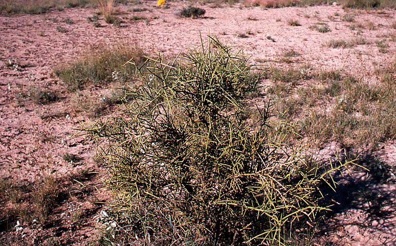
160. Spiney all around- Plant of spiny allthorn or, simply, allthorn or junco (Koeberlinia spinosa var. spinosa). growing on ecotonal grassland that was part of a broad transition zone between semiarid Staked Plains mixed prairie and arid Trans-Pecos semidesert grassland. This was in the Marfa Basin at eastern margin (Trans-Pecos) Basin and Range physiographic province. This plant seen here was part of banded vegetation in a swale habitat on which blue and black grama were co-dominant climax grasses.
Allthorn is in its own monotypic allthorn family (Koeberliniaceae) (Correll and Johnston, 1979, 1074) and is regarded as ideal cover and feed habitat certain wildlife species, especially quail (Powell, 1988, p. 297). It certainly is a classic example of evolutionary adaptation to xeric environments, and an attention-grabbing plant.
According to Vines (1960, ps. 299) allthorn (in one of its varieties or the other) has a species range extending from the Gulf of Mexico across to Arizona and deep into the Republic of Mexico (Tamaulipas, Sonora, Hildago). In Texas, allthorn is found in the Coastal Prairies and Marshes, Rio Grande Plains, Edwards Plateau, Rolling Red Plains (Redlands), and Trans-Pecos Basin and Range vegetational (= land resource) areas (Gould, 1962, p. 63). hence, this species is not strictly a desert plant by any stretch of imagination. Nonetheless, spiny allthorn is a characteristic plant of the Chihuahuan Desert and adjoining semidesert grasslands (as well as transitional grasslands such as examples featured here). Shreve and Wiggins (1964, ps. 936-937) described both K. spinosa var. spinosa and K. spinosa var. tenuispina for the Sonoran Desert with the latter variety limited to the Lower Sonoran Zone (ie. K. spinosa var. spinosa is much more widely distributed).
Presidio County, Texas. Mid-October; ripe-fruit phenological stage.
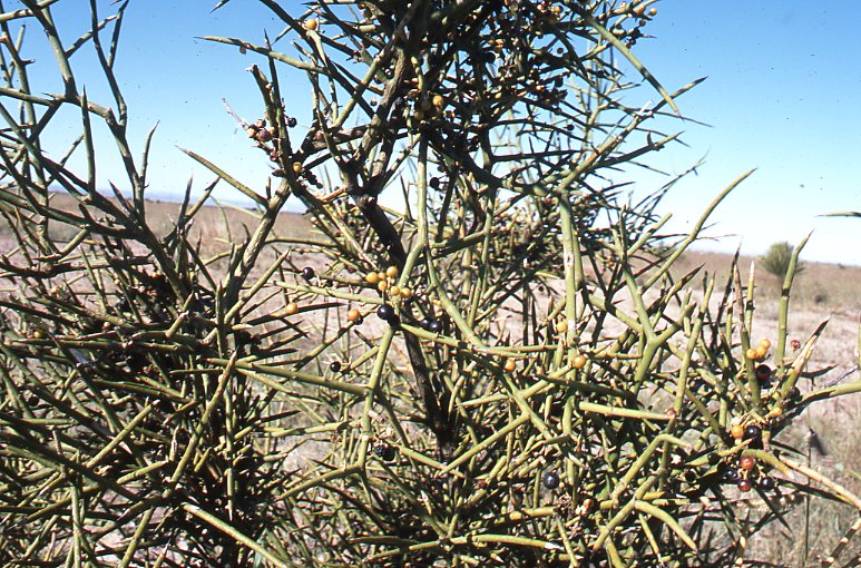
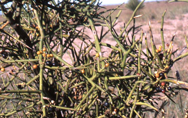
161. Thorny customer on an ecotone- Fruit (berry)-bearing branches of allthorn that was part of a climax plant community that developed in the form of banded vegetation (explained below) in the Marfa Basin of Trans-Pecos Texas in an ecotonal grassland in this eastern edge of the Basin and Range physiographic province. Leaders (branches) in these two photographs were on the same plant that was introduced in the immediately preceding slide.
This highly branched shrub to, occasionally, small tree with its green-barked, photosynthesizing (and spine-tipped) branches is largely leafless with ephemeral leaves typically reduced to small scales (Vines, 1960, p. 299; Shreve and Wiggins, 1964, ps. 936-937; Correll and Johnston, 1979, p. 1073-1074). Shreve and Wiggins (1964, ps. 936-937) described allthorn as having "rigid, often interlocking, spinose branches". This branching pattern forms an intricate, interlocing, spine-tipped "botanical barricade" that is nearly impenetrable to all but invertebrates and smaller vertebrate species such as reptiles, birds, and mammals which are safely tucked inside a natural breastwork from most predators. The abundant berries are a feed source for animals as well. All in all a very hospitable habitat for those who can enjoy it.
Presidio County, Texas. Mid-October; ripe-fruit phenological stage.
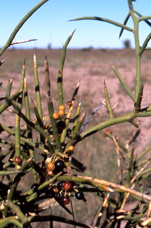
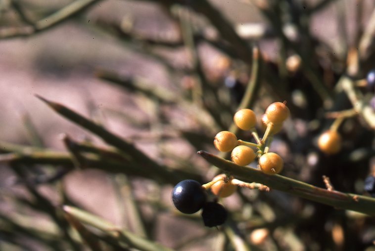
162. Spines and berries in banded vegetation- Leafless, spine-tipped, green-barked leaders with ripening berries (first slide) and berries in various stages of maturity with spine (second slide) of spiny allthorn growing in banded vegetation in a swale environment in the Marfa Basin of the eastern (Trans-Pecos portion) Basin and Range physiographic province. Coulter (1891-1894, p. 55) described K. spinosa (no variety given) as a "curious shrub or, sometimes arborescent, apparently destitute of leaves with green stiff very intricate branches tapering into thorns". He went on to describe " minute scale-like caducous leaves" and the fruit as "a small subglobose berry" (Coulter, 1891-1894, p. 55).
According to Allred and Ivey (2012, p. 371) there are three other taxonomic varieties of K. spinosa besides variety spinosa with K. spinosa var. wivaggii the variety in New Mexico. Given close proximity of this Trans-pecos Texas specimen to New Mexico, the specific variety of this plant might be subject to interpretation, but Powell (1988, p. 297) clearly placed all Trans-Pecos spiny allthorn plants in variety spinosa.
Neat plant species to share with fledging students in Range Management, Wildlife management, Conservation Biology, etc. and folks with interests in the amazing natural world.
Presidio County, Texas. Mid-October; ripe-fruit phenological stage.

163. Across the line State Flower- Specimen of soaptree or soaptree yucca (Yucca elata) on transition grassland--between semiarid Great Plains mixed prairie and arid semidesert grassland--dominated by gramagrasses (blue grama, black grama, sideoats grama) on a swale site in the Marfa Basin of Trans-Pecos Texas. Soaptree yucca is the predominant Yucca species on semidesert grassland, but on this transition grassland there were also plants of Faxton's yucca (Yucca faxtionana). In fact, on these ecotonal grasslands there were typically more individuals of Faxton's yucca than of soaptree yucca, except on lower habitats such as swale sites and similar range environments that had what is known as banded vegetation (Tongway et al., 2001). This phenomenon of banded vegetation was described below.
Both of these Yucca species have a woody caudex (basal woody shoot or, at least, semi-woody trunk) and are described as arborescent (treelike). Dead leaves still attached to this woody caudex form a "skirt" (and do not try to lift it up; vermin frequently live in there).
The State Flower of New Mexico is a generic yucca or yucca flower (not species-specific; all Yucca species native to the state), but traditionally it was assumed by many New Mexicans that soaptree yucca was the "real" state flower. Anyway, this specimen was growing across the state line in the Lone Star State rather than in the Land of Enchantment.
Presidio County, Texas. Mid-October.
Location notice: several more examples of Yucca elata were presented in the grasslands chapter, Semidesert Grasslands herein.


164. Examples of Faxton's legacy- Two examples of Faxton's yucca (Yucca faxoniana) growing on a transition grassland that was ecotonal between arid semidesert grassland and semiarid Staked Plains mixed prairie. This was in the Marfa Basin at the eastern (Trans-Pecos Texas) portion of the vast Basin and Range physiographic province. Major plant species were perennial gramagrass species (black and blue grama were generally co-dominants with sideoats grama the associate species). There were also a few plants of Y. elata present, but there were more plants (greater foliar cover) of Faxton's yucca on higher slopes while soaptree yucca predominated on swale sites and those with banded vegetation (Tongway et al., 2001). This banded or "stripped" pattern of grassland vegetation was discussed below.
The arborescent (treelike; resembling or becoming a tree versus arboreous; being a tree) Yucca species remain a confusing lot with interpretation and treatment differing among various authorities. Vines (1960, ps. 51-54), Correll and Johnston (1979, ps. 397-400 passim), Powell (1988, p. 62), and (Allred and Ivey, 2012, p. 569) included both-- and distinguished distinctly between--Y. treculeana and Y. faxoniana. In addition to Y. faxoniana and Y. treculeana, Vines (1960, ps. 51-54) and Correll and Johnston (1979, ps. 397-398) recognized Y. carnerosana while Powell (1988, p. 62) showed Y. carnerosana as a synonym for Y. faxoniana. Y. faxoniana and Y. treculeana are quite similar (allegedly even hybridizing); so much so, in fact, that Powell (1988, p. 62) separated these two on basis of pistils 40 mm long or less (Y. treculeana) versus pistil 45 mm long or longer (Y. faxioniana), but the ever-observant Vines (1960, p. 51) showed clearly that Y. faxoniana had long, prominent fibers along margins of leaves while leaf margins of Y. treculeana were devoid of such fibers. Correll and Johnston (1979, p. 395) also noted that Y. treculeana was "without free fibers", but they did not refer to to leaf margin fibers in Y. faxoniana in either this dichtomoous key or their species description.
Distinct fibers on margins of leaves of both specimens presented above this caption provided unequivocal evidence (positive identification) of these plants as Y. faxoniana. The capsule-bearing, spent inflorescence that did not extend above upper leaves in the second specimen distinguished Y. faxoniana (or Y. treculeana) from Y. elata (see immediately preceding slide of Y. elata).
Vines (1960, p.51) specified that the commemorative specific epithet faxoniana (often capitalized as Faxoniana) was given in honor of Charles Edward Faxon the principal artist for the silva and manual of North American trees by Sargent (1933).
Brewster County, Texas. Mid-October.

165. No welcome sign here- The land behind this gate was the transition blue grama-black grama Trans-Pecos grassland featured above. The author was run off of this private property by the owner. In the process of photographing range plants and vegetation over the course of 35 years on public and private land from the Canadian provinces to the Rio Grande this was the only place the author was driven off of. On various occasions a land owner has stopped and asked the photographer what he was doing (usually with a "Can I help you?" by the owner). As soon as the photographer explained that he was a professor getting photographs to use in Range Management courses the property owner would either say something like "hope you found something you could use" or immediately start offering suggestions on where to find other examples.
This was not the case behind this gate. After attending the 65th annual meeting of the Texas Section, Society for Range Management the author parked (with car unlocked) off the side of a railroad-ranch access road on the right of way of Highway 90 and 67 in east Presidio County, Texas. Just as the author was in the process of taking his last slides of side-by-side inflorescences of black and blue grama a sport utility vehicle, a white Lincoln Navigator, pulled up (off of the ranch road onto the grass). The author approached the vehicle with a woman driver and hippie-looking young man riding shotgun. With camera in you're your author said, "Howdy, I'm Randy Rosiere, a professor of Range Management at Tarleton State University. I'm trespassing to steal a few images of this nice range for my college courses in Range Management". The driver replied, "You're trespassing alright so get off". The author responded, "Yes ma'am, now I'm not hunting or taking anything but these pictures. And I am a member of the Texas Southwestern Cattlemen's Association (in pointed reference to the TSCRA sign on the gate which the author had shut). "I know you're not hunting because I see the camera, but you may leave anyway". "Could I get one last picture (having just set up Bouteloua racemes for a last side-by-side comparison)?". No, you may leave, now" Yes ma'am. Thank you".
As your expelled professor left the pasture and cleared the gateway he said to the young man, "I'll give you folks credit: you're unique. In a third of a century of taking photographs for my classes this is the only time I've been run off a place once I explained what I was taking pictures of ". The rather handsome man had shoulder length brown hair, studs in his ears, and a silver necklace around his neck that extended to his waist. He had never stopped smiling throughout course of this encounter. His was a friendly and, it seemed to me, a rather sheepish or amused smile. His big, toothy grin was not a smerk or a haughty, contemptible snarl. Not in the least. This fellow had a neighborly countenance and responded kindly to the exiting statement, "Well, mother is just concerned about her land. She thought you might find an endangered species on it and the government would keep her from doing what she wanted with it". Your author, who is also the son of an elderly mother, now suspected that that this son (who was in the process of shutting the gate), was indulging his hostile, haughty, inhospitable mother. So the photographer tried to reciprocate the smile and said" Whatever, but the Endangered Species Act applies only to public property or publicly funded projects and not to privately owned land. If there was an endangered species on this range, you could still plow it up and turn it into a cotton patch or flood it for a rice paddy. Thanks for catching the gate".
The ever-smiling handsome hippie closed the gate and then ran back to his unimpressive sport utility vehicle which he had parked perpendicularly with the tail gate down behind the photographer's rental Chevy Impala. (The Chevy could easily have backed around the SUV.) As your shutterbug "illegal alien" pulled out on Highway 90 he noticed the bumper sticker on the right rear of Lincoln Navigator. It ended with the words: "God made ranchers".
In spite of arrogance, humiliation, paranoia, and inhospitality this brief encounter was positively fortuitous from the perspective of education, especially for younger or incoming members of the Range Management profession. The photographer had only one or, maybe, two (one for backup) slides to take before the Lincoln Navigator pulled up. In fact, he could have snapped them quickly, but did not want to rush a shot and had no inkling that he would be driven off once he explained his unauthorized presence. Inside of six or eight minutes the photographer would have been down Highway 90.
Your excoriated photographer had taken photographs of the gate with all signs but the welcome sign prior to arrival of the selfish landowner. These photographs were taken with the intent to show the outstanding example of good rangeland stewardship behind the gate. Your author has employed this teaching technique frequently-thought not nearly as frequently as he would have liked-throughout this publication. This is in the same spirit as the awards given for outstanding examples of land stewardship, wise and proper use of natural resources, by organizations ranging from various sections of the Society for Range Management to the National Cattlemen's Beef Association. That is properly done at this point. Even more to the point was the apparent fact that this range had received good grazing husbandry for years, quite likely for decades and maybe a few human generations. It was unlikely that the current owner was solely responsible for the near pristine condition of this range. Certainly one must give the devil her due and applaud her for current good husbandry of this range. Not only had she (and any others involved) not beat the forage resource into an eroded soil, but this range had been destocked during the past year or more of bad drought. Well done!
The singular event (one time over a span of 35 years of range photography) of a college instructor being run off of a ranch while in the course of gathering teaching images trumped the much more common situation of good range stewardship and extreme hospitality of neighborly ranch people.
Thereupon came another and quite unintended lesson in Range Management-and in Life.
Synopsis: Yes, the range was private property. Apparently the driver of the Lincoln Navigator was the owner and presumably she paid the property taxes. The land was hers to do with as she saw fit, including keeping anyone off she chose. (It was also a fair assumption that with a place this big she had inherited or married it. It was likely a third to fifth generation estate.) This woman owned the property, paid the taxes, had the property rights, and was perfectly within her rights to drive off the trespassing teacher. Her response to a trespasser was legal. She was well within her rights as a tax-paying land owner to keep off whomsoever she chose (and for whatever reasons) regardless of how she got the land. The United States of America is a government of laws, and this land owner knew her constitutionally protected rights as a property owner. A free people give thanks for and are ever ready to defend property rights. That's the rules.
There is another set of rules. They are best known as the Code of
the Cow Country:
"It don't take such a lot of laws to keep the rangeland straight,
nor books to write 'em in as they's only six or eight.
The first is the welcome sigh wrote deep in western hearts,
My camp is yours and yours is mine in all cow country parts …"
Probably the most revered, the almost sacred, rules or customs among pastoral, indeed, among all rural people is what passes generally as hospitality or neighborliness. These words do not completely express the depth and intensity of "hanging out the latch string". Welcoming strangers is a key feature of the Abrahamic or JudeoIslamicChristian tradition. Legend has it that, weather permitting, Abraham and Sarah kept three sides of their tents open so as to see approaching strangers for whom they would prepare food and drink (). Among the nomadic Hebrews the stranger and the sojourner were treated with open-hearted kindness and care. "Also thou shall not oppress a stranger: for ye know the heart of a stranger, seeing ye were strangers in the land of Egypt" (Exodus 23:9). This time-tested command was extended to the American frontier where a standard salutation-complete with its fulfillment-was simply: "Light and eat, stranger".
This sharing of what one has with travelers, strangers, or those who have less was never more beautifully stated that in the Spanish "Me casa es sue casa" (My house is your house"). The Grapes of Wrath by John Steinbeck, 1938) has been acclaimed by many literary critics as the greatest American novel. Steinbeck ends his morbid yet magnificent tale of down-to-nothing Okies with Rose of Sharon breastfeeding a starving man, an unnamed stranger. To violate the heritage of welcomeness was an egregious violation; far more than even a discourtesy or an insult. It goes to the very heart of what defines a people and the covenant among themselves and with those they have never met or, at most, will likely never meet again.
In another light, it is the tradition and responsibility of the "welcome mat" that makes possible property rights. The responsibility of the "welcome sign" is not part of legal statues-at least not those as written-but it can be seen as an "impromptu tax", part of the cost of owning and enjoying the benefits of property rights. (Incidentally, if someone is going to invoke 'the law", such as the Endangered Species Act for instance, it would seem reasonable that such person would know what the invoked act actually stated.)
By the way, the next line of the Code of the Cow Country is this:
"Treat with respect all womankind same as you would your sister".
The professor obeyed this dictum when he said "thank you"
following his eviction by a crotchey ole sister.
Aside from the necessity of "vacating the premises" before
the ole crotch calls the sheriff on you, the rules for responding
to such infractions of common decency and neighborliness were given
by Jesus:
"And whosoever shall not receive you, nor hear you, when ye depart
thence, shake off the dust under
your feet for a testimony against them. (Mark 6:11).
Barring a miraculous road to Damascus I-saw-the-light conversion the present landowner is not worth wasting any time on. She is a goner, a lost soul from a ranching culture perspective. Leave and good riddance. The hard-boiled, hard-hearted, hard-headed cases like this battle-ax are too far gone to be saved (again with nothing less than a Rhett Butler conversion on the road to Tara). Hope lies with the younger generation, the smiling, good-natured, apparently open-minded ranch hippie son in this case.
The occupation of this hostile, inhospitable landowner was unknown to the writer. Her hoity toity school marmish nature certainly reminded him of some battle ax teachers he had been burdened to know. What was obvious to this experienced observer was that she was definitely not a ranch woman, regardless of how much ranchland she might own. Ranch women can be as tough as a cedar knot when they have to be; and they can be as gracious, outgoing, tender and sharing when that need arises. Thankfully, this rank gal was the exception to a group composed of some the finest examples of womanhood.
Consumption of-as in the use, taking, or buying-of something that is used up (whether or not it can be replenished) such as agricultural commodities certainly go beyond the point at which welcomeness or neighborliness could be reasonably expected. A visitor (that is, the non-owner) to a ranch would be expected to pay for products used, including amenities such as sight-seeing beyond the casual or momentary. This is payment for the privilege of ingress. The point at which ingress goes beyond a dutiful neighborliness, welcomeness, or sharing of one's bounty is obviously subject to interpretation. Paying a fee for ingress on private property for the purpose of quail hunting is obvious. Paying for an afternoon of bird or butterfly watching may be less obvious yet just as legitimate for collection of fees. What about an incidental crawl over a fence for a half hour to watch a "black bird" or photograph black grama, especially if such activity is for purposes of publicly funded (tax-supported) education or if it is made available to the world for free on the Internet?
It seemed to this photographer that the privilege to ingress upon another's land on foot and with camera to take nothing except images for use in public education was a lesser intrusion than entry in a motor vehicle with firearm or bow to take away an actual item like game. This is a photographer's biased view, but apparently the local game warden with Texas Parks and Wildlife shared that perspective when an hour before and a mile back he talked to this photographer taking images of range on adjacent private property.
Ethics and philosophy (often clearly separate from legal necessities) in such matters quickly and, often, inevitably become cloudy and convoluted. The day before the encounter between the trespassing professor and the landed wet hen, a 91 year-old rancher (born in 1923) was reflecting on his life and recollecting his experiences ranching in Presidio County, Texas as part of the program of the Texas Section, Society for Range Management meeting . This old timer appeared to spend more time recounting problems with the screwworm fly (Cochliomyia hominivorax) and the effectiveness of the federal (United States Department of Agriculture) screwworm fly eradication program than any other aspect of his ranching life. Almost beyond doubt, the rancher who owned or rented the land that the wet hen now owned had also benefitted from this federal subsidy, as for that matter had wet hen rancher who would have faced screwworm losses without the tax-supported program. Tax-funded education in Entomology and Physics (as in irradiation) was essential to success of the screwworm eradication undertaking. A less known fact regarding outcome of the highly effective screwworm eradication endeavor was the population explosion of both white-tailed and mule deer (Odocoileus virginianus, O. hemionus).
Likewise, game protection (namely reduction in poaching) through law enforcement was a major factor-at least in initial stages-in restoration of deer populations. This was also a tax-funded government program, one supported from sales of game and fish licenses and taxes levied on firearms, ammunition, etc. This program was initiated by sportsmen themselves. Thus, wildlife and fish restoration on range, forest, and cropland was a multi-faceted partnership of sportsmen, landowners, and "the government" (at various levels). When ranchers, quite appropriately, charge an ingress fee for privileged use of their property for the also privilege of pursuing game or fish these landowners are renumerated for their part in wildlife conservation via provision of habitat. Landowners can rightly capitalize on this part of their property rights and, hopefully, get a return on their investment.
It is also true however that sometimes property owners get a "windfall" from public investments. Landowners frequently get returns from their taxes that are far greater than the non-landowning taxpayers get from a comparable rate of taxation. In effect this is a gift. The case of screwworm fly eradication was a case in point, but conservation cost-sharing (incentive) programs, especially payments like the Conservation Reserve Program that reward poor land stewardship, is a whole category of such subsidies. Yes, society should benefit from conservation of natural resources in the form of lower grocery, fuel, and clothing prices, but the grower benefits more directly plus also as a consumer himself. The same situation exist for higher education. Like all public education, when higher learning is publicly funded or supported (at least more or less) society is saying that this is a public good or service, much like public defense or postal services, that is essential or, at least, desirable for the public at large. As such, society subsidizes higher education for students. Society benefits overall, yet the subsidized student benefits more.
Such a beneficial arrangement has existed historically, at least until in the late 20th and early 21st centuries when grade inflation and course content deflation rendered most Bachelor degrees counterfeit diplomas. Combined with unimaginable student debt, much of the previous advantage of a so-called college degree has evaporated. Nonetheless, a societal-individual citizen interrelationship still exist. It constitutes a two-way thoroughfare such that whatever benefits accrue, they are greater for the recipient who got direct government aid. It would seem fair and reasonable to assume that such recipients have a debt owed to society, and that they should realize and at least partially repay this debt so as to benefit those follow them.
This author did not know if the inhospitable landowner who ran him off her land had received any such cost-sharing or other subsidies whether through public assistance in conservation, higher education, or other similar societal investments in her. Even if the previous owner had gotten conservation incentive payments like those through the Great Plains Conservation Program unbeknownst to the current owner this would have benefitted her through range improvement. (The current sixty or seventy year-old owner could not have received cost-sharing, price supports, or related monies when such programs began in the 1930s or even 1950s yet she would have benefitted from previous government-supported conservation efforts the same as if she received such assistance through current programs.)
Given such "windfall benefits" (those that were basically
gifts or returns for which the owner had made minimal investments)
it might be argued that the landowner could be expected to return
something to society, especially when it would cost her nothing to
do so (e.g. letting a cow college professor walk on her land to take
slides that would be used in teaching students about range conservation
so that they in turn could be federal range conservationists helping
with cost-sharing range improvement projects). A small return on the
return if you will.
"For unto whomsoever much is given, of him shall be much required
…"
-- Jesus (Luke 12:48)
Herein lays a confounded and complex socioeconomic relationship. Many
landowners are benefitting from cultural-political arrangements and
advantages made possible by tax monies. Yes, these landowners paid
"their fair share", but it took collective action on the
part of the citizenry at large. All motorists pay road taxes, but
the taxes paid by any one motorists would not pave or maintain nearly
as much road as he drives over. This is why there are public works,
roads, conservation programs, etc. (i.e. why people agree to communal
or collective action). All benefit, at least in theory. Yet, some
benefit more than others. Sometimes this is something that the biggest
beneficiaries had nothing to do with. Again, it was a "windfall"
or gift. The red meat consumer benefits from the screwworm eradication
program or brush control projects, albeit not nearly as much as does
the stockmen. Only the God who made ranchers could sort this all out.
The fact remains that there are "incalculables" that cannot be answerable by mere legal arrangements. The open range cowhands had the wisdom to know this. They came up with their own code which at one time or the other had extralegal and illegal aspects as well as legal ones. Their ancestors Abraham and Sarah had the same sort of wisdom regarding strangers and fellow sojourners long before Moses arrived with the ten commandments and Mosaic law.
Even with such "incalculables" or "imponderables" there remains the philosophical concept that those who have more-whether they earned or received it as a gift or inheritance-are reasonably expected to give back more. This is the historical view of noblesse oblige (the obligation of the nobility). The requirement of greater responsibility for those who have been more greatly blessed has traditionally been applied to all property rights including, for example, the property right of faculty tenure among universitymen. In the University, tenured senior faculty have the obligation (the duty or responsibility) of doing the heavy lifting in matters of academic freedom, shared governance, and controversial or risky decisions. Such obligation followed by appropriate courageous action protects the more vulnerable untenured members of the professoriate who, once they receive the tenure property right with its additional protection from potential retaliation from university administrators, will be expected to return interest on academic debts that they incurred while being protected as vulnerable untenured professors before they earned the property right of faculty tenure. This author would rationally apply this obligation of basic decency and neighborliness to property owners who are fortunate to have land that can yield societal goods and services (such as educational opportunities) in addition to beef, wool, or trophy deer mounts.
Holders of property rights in land, water, minerals, or faculty tenure have obligations to society that extend beyond legal responsibilities such as paying taxes, building effective fences, and teaching classes. One such obligation is neighborliness, even though it is not on the law books. Fundamental courtesy and common respect are social mores and valid rules of "right-living" among one's fellow man even if they are not legal requirements. Yes, legally the haughty, tax-paying landowner was well within her right s to run off the cowboy photographer; and his expectation of the courtesy to take photographs on her pasture for use in public education was consistent with the time-honored tradition and cow country culture of a range welcome.
"Always get the landowner's permission". A timeless truism for the hunter or fisherman who is a relative or friend of the landowner or a customer paying for the privilege of ingress during a set game or fish season, but almost always an impossibility for a photographer "just passing through". Landowner permission is also a legal responsibility and one typically that is comparatively easy to satisfy for a federal soil mapper who has adequate time and the routine wherewithal to locate landowners or their responsible representatives long before soil mapping commences on a property. In the case of the "passing through" photographer (versus a resident photographer who lives in the community or neighborhood in which he takes photographs) those browsing elk or that wild Longhorn cow and her calf are not going to be there by the time the photographer could get permission. This is, after all, a procedure that could take from hours to weeks, depending on landowner availability (many of the well-heeled ranch owners travel abroad and had unlisted telephone numbers even before the days of cell phones) and familiarity with and the efficiency of the process through which landowners can be tracked down through county records and officials. Even plants move as they grown (and many phonological stages, such as anthesis, are remarkably short-lived) and, more importantly, are moved by the wind. The time available for photographs of a plant or plant species when the air is still, light available (as in a dense forest or north slope), and the life process ongoing may be almost as limited as that Longhorn pair hightailing it for a cedar-choked canyon.
Furthermore, the landowner might be some paranoid ole bitty citing
the Endangered Species Act (or some other imagined boggeyman lying
in wait to steal her property) who would not have given permission
anyway. The instance described above is a textbook of the adage, "It
is easier to get forgiveness [o, in this case, photographs] than to
get permission". In this instance the photographer got chewed
out and run off, but first he got his shots. The remote risks of getting
run off or shot are part of the cost of doing business and much less
than risks of being injured photographing wild animals, including
livestock, or wild plants in precarious places. Furthermore, one such
chance encounter (in over a third of a century) with a banty hen and
her ruffled feathers (or her panty in a wad) made for a great story
and a good lesson to aspiring range and nature photographers. Such
are the "interpersonal skills" mouthed by those who come
up with prescribed behavior for situations that typically they have
never been in yet for which they prescribe appropriate action. As
just explained, even conventional wisdom like getting landowner permission
is sometimes inappropriate or impossible.
"Everything that has been tried before will not work in New Mexico."
-- Territorial governor Lew Wallace
Teacher, hunter, or neighbor, one always sets an example-for better or worse. It would seem prudent to try to set as good an example as possible. One never knows who may be watching, including the Big Boss who made ranchers.
Life on the range, as in all human relations, is a dynamic interaction
of give and take. Likewise, there is a dynamic and, sometimes, delicate
balance between the needs and wants of the individual and those of
the community. Rudyard Kipling stated this well in his poem, The Law
of the Jungle:
"Like the creeper that girdle the tree trunk the law runneth
forward and back,
for the strength of the pack is the wolf and the strength of the wolf
is the pack".
That pasture gate swings both ways.
In the range environment it is often to one's advantage to refrain from exercising all his rights because the other party has the option of exercising his rights as well. In this case of the game of range dare base between an inhospitable land owner exercising her property rights and the trespassing professor, the latter was driven from his opponents private property base only to return to and come off of his base line last and circle the landowner's line. The escorted-off professor exercised his free speech rights to give a little lecture from outside a gate without a welcome sign. Maybe some neighbors recognized the gate, laughed at the story (with perhaps a shared experience), and remembered to keep the welcome sign written in their hearts.
Presidio County, Texas. Mid-October; early autumn.

166. Marfa Basin ecotone- An ecotonal grassland developing between the mixed prairie and shortgrass plains of the Staked Plains or Southern High Plains and semidesert grasslands of the Trans-Pecos Basin and Range is a transitional grassland that is perhaps best described or envisioned as a "blend" of the two spatially larger grasslands. It can be thought of as interzonal vegetational, a "hybrid" grassland that is in gradual transition from the semiarid zone and its zonal mixed-shortgrass regional grasslands and the arid zone regional grasslands, known as desert plains (the once-popular term used by F.E. Clements for near-desert) semidesert grasslands.
Such climax grassland range is especially prominent and distinctive in the Marfa Basin of the Texas Big Bend area. The synopsis or summary view of this ecotonal Southern or Staked Plains-Basin and Range grassland seen here, and in subsequent slides presented and described immediately below, treated of this unique grassland ecotone.
Range vegetation in the slide seen here included the conspicuous though still relatively small (young?) soaptree (Yucca elata). There were also comparatively small (younger?) plants of Spanish bayonet or Faxon yuca (Y. faxoniana), typically the largest Yucca species in the Trans-Pecos Region (Powell, 1988). Leaves are characteristically thinner (less fleshy) on Y. elata than on Y. faxoniana or Y. trculeana. The number and diversity of grass species on this range and others presented below was amazing. Grasses included sideoats, blue, and black gramas; plains lovegrass; plains bristlegrass; green sprangletop; cane bluestem; galleta; Havard's threeawn; Arizona cottontop; and wolftail. These were all eragrostoid or panicoid grasses; the photographer found no festucoid species in this otherwise rich array of native, warm-season perennial grasses.
The most common forb species were desert zinia (Zinia grandiflora) and paperflower (Psilostrophe tagetina). Another shrub of infrequent, yet conspicuous, presence was spiny allthorn (Kobeleria spinosus). There were also some specimens of threadleaf snakeweed (Gutierrezia microcehhalia). Most of the composites were at or near full-bloom stage of phenology.
Intermingled areas of bare soil and patches of grass cover formed a pattern often described as banded vegetation (Tongway et al., 2001). Whether this patchwork pattern of vegetation cover is natural under typical conditions, caused by drought, induced by overgrazing, or some combination of some or all of these factors was not known.
Presidio County, Texas. Mid-October; early autumn. FRES No. 38 (Plains Grassland Ecosystem)-No. 40 (Desert Grasslands Ecosystem). K-62 (Bluestem-Grama Prairie)-K-48 (Grama-Tobosa Prairie) transition. SRM 707 (Blue Grama-Sideoats Grama-Black Grama). No appropriate classification unit in Brown et al. (1998). Range site: Gravelly or Gravel Slope (Natural Resources Conservation Service, 2013). Chihuahuan Deserts- Low Mountains and Bajadas Ecoregion 24c (Griffith et al. 2004).


167. Ecotone banded in the Marfa Basin- Two near-each-other views of transition zone grassland between Staked Plains mixed prairie -shortgrass plains grasslands and Basin and Range semidesert grassland in the Marfa Basin of Texas Big Bend area. This grassland ecotone was represented in these two views by at its climax form, but that was just recovering from a prolonged drought (it had reached the stage of Extreme Drought on the Palmer Index) following this year's near record-breaking summer and early autumn rainfall.
This grassland vegetation frequently has long patches of herbaceous (almost all grass) cover intermingled with areas of bare soil. This pattern is recognized as banded vegetation (Tongway et al., 2001). It was not known if this is a natural pattern that developed under "average" environmental conditions or induced by recent drought, past overgrazing (this range was currently destocked from a just-broken Extreme Drought), or some combination of these factors. Banded vegetation was more obvious in the second of these two slides.
Range plant species present included soaptree yucca, Spanish bayonet or Faxton's yucca, and, among the grasses, sideoats grama, blue grama, black grama, cane bluestem, plains lovegrass, plains bristlegrass, wolftail, galleta, Arizona cottontop, and Havard's threeawn. Forbs were limited with desert zinia and paperflower the two most common species.
The first slide, which presented more of a summary view of this climax ecotone grassland vegetation, was an example of the spatial arrangement of grass species on this range. In left foreground (slightly left of center to margin) was cover of black grama while grass cover cover in right foreground (slightly right of center to right margin) was that of blue grama. Such side-by-side location is quite common on this ecotonal grassland which frequently has the banded vegetation pattern described two paragraphs above. This dispersion pattern was even more conspicuous in the first of the two-slide set immediately below.
Presidio County, Texas. Mid-October; early autumn. FRES No. 38 (Plains Grassland Ecosystem)-No. 40 (Desert Grasslands Ecosystem). K-62 (Bluestem-Grama Prairie)-K-48 (Grama-Tobosa Prairie) transition. SRM 707 (Blue Grama-Sideoats Grama-Black Grama). No appropriate classification unit in Brown et al. (1998). Range site: Gravelly or Gravel Slope (Natural Resources Conservation Service, 2013). Chihuahuan Deserts- Low Mountains and Bajadas Ecoregion 24c (Griffith et al. 2004).


168. Ecotonal Grassland- Climax grassland that was an ecotone between Llano Estacado (Staked Plains) mixed prairie -shortgrass plains grasslands and Trans-Pecos Basin and Range semidesert grassland in the Marfa Basin of Texas Big Bend Country. Range plant species included the shrubs, soaptree yucca and Faxton's yucca or Spanish bayonet and, much less frequently, spiny allthorn. The rich array of grasses included blue grama, black grama, sideoats grama, cane bluestem, green sprangletop, Havard's threeawn, plains bristlegrass, galleta, plains lovegrass, wolftail, Arizona cottontop, and Hall's panicgrass (Panicum hallii), but there were few forbs in these two "photo-plots". The suffrutescents species, latherweed croton (Croton pottsii) was scattered throughout the range vegetation shown here.
The first slide provided a textbook example of the spatial arrangement or plant species pattern widely found in this transition grassland. A single grass species commonly covers a comparatively large area (forms a relatively big patch of cover) immediately adjacent (contiguous with) a similar large patch of another grass species. In this first slide there was the outer edge of a patch (a colony or population) of sideoats grama ran obliquely from right-center foreground to right background (right margin of slide) while grass cover at left-center foreground to left two-thirds of the photograph was a mixture made up largely of blue grama and black grama with some of the other listed grass species being present as scattered individuals.
A more-varied composite ("mixture") of the numerous grass species was presented from lower camera height in the second slide. The grass sward presented in the second slide included many of the grass species listed in the first paragraph.
Presidio County, Texas. Mid-October; early autumn. FRES No. 38 (Plains Grassland Ecosystem)-No. 40 (Desert Grasslands Ecosystem). K-62 (Bluestem-Grama Prairie)-K-48 (Grama-Tobosa Prairie) transition. SRM 707 (Blue Grama-Sideoats Grama-Black Grama). No appropriate classification unit in Brown et al. (1998). Range site: Gravelly or Gravel Slope (Natural Resources Conservation Service, 2013). Chihuahuan Deserts- Low Mountains and Bajadas Ecoregion 24c (Griffith et al. 2004).


169. Transition in the Marfa Basin- Climax ecotonal range vegetation in the Marfa Basin that was a transition zone grassland between Trans-Pecos Basin and Range semidesert grassland of the arid zone and Llano Estacado (Staked Plains) or Southern High Plains mixed prairie -shortgrass plains grasslands of the semiarid zone. This amazing "blend" of grasses and grasslands included the following Gramineae species: Bouteloua curtipendula, B. eriopoda, B. gracilis, Andropogon barbinodis, Setaria leucopila, Hilaria jamesii, Lycurus phleoides, Eragrostis intermedia, Leptochloa dubia, Trichachne californica, and Panicum hallii.
Shrub species included Yucca elata, Y. faxoniana, and Kobeleria spinosus, a specimen of this his latter species was featured in the lower left foreground of the second slide. The two most common forbs on this particular range were Zinia grandiflora and Psilostrophe tagetina. The suffrutescent Croton pottsii was also widely dispersed.
In the foreground of the first slide blue grama (B. gracilis) was the smaller plant on the left while black grama (B. eriopoda) was the larger plant on the right. These two species with sideoats grama (B. curtipendula) were the tri-dominant range plant species on this range (and the three climax, decreaser dominants of this range site).
Presidio County, Texas. Mid-October; early autumn. FRES No. 38 (Plains Grassland Ecosystem)-No. 40 (Desert Grasslands Ecosystem). K-62 (Bluestem-Grama Prairie)-K-48 (Grama-Tobosa Prairie) transition. SRM 707 (Blue Grama-Sideoats Grama-Black Grama). No appropriate classification unit in Brown et al. (1998). Range site: Gravelly or Gravel Slope (Natural Resources Conservation Service, 2013). Chihuahuan Deserts- Low Mountains and Bajadas Ecoregion 24c (Griffith et al. 2004).

170. "Hybrid" grassland- Structure and composition of sward of a grassland ecotone between Southern High Plains (Staked Plains or Llano Estacado) mixed prairie -shortgrass plains grasslands of the semiarid zone and Trans-Pecos Basin and Range semidesert grassland of the arid zone . Grass species present were the tri-dominants sideoats grama, blue grama, and black grama plus cane bluestem, galleta, Havard's threeawn, Hall's panicgrass, plains bristlegrass, green sprangletop, Arizona cottontop, wolftail, and plains lovegrass. These were all eragrostoid or panicoid (Eragrostoideae and Panicoideae subfamilies) species.
There were no forb or actual shrub species in this "photo-quadrant", but the subshrub or suffrutescent species, leatherweed croton, was well distributed as, for example, in the lower right corner.
Th;is sward was in the Marfa Basin, part of the Trans-Pecos portion of the Basin and Range physiographic province.
Presidio County, Texas. Mid-October; early autumn. FRES No. 38 (Plains Grassland Ecosystem)-No. 40 (Desert Grasslands Ecosystem). K-62 (Bluestem-Grama Prairie)-K-48 (Grama-Tobosa Prairie) transition. SRM 707 (Blue Grama-Sideoats Grama-Black Grama). No appropriate classification unit in Brown et al. (1998). Range site: Gravelly or Gravel Slope (Natural Resources Conservation Service, 2013). Chihuahuan Deserts- Low Mountains and Bajadas Ecoregion 24c (Griffith et al. 2004).

171. Ecotonal mixture of co-dominants- Sideoats grama (left; taller, yellowish-brown shoots) and blue grama (right; shorter, greenish-grey shoots) as two of three overall tri-dominant grama grasses (black grama was third tri-dominant as presented in the sister slide immediately below) on an ecotonal grassland that was transitional to Trans-Pecos Basin and Range semidesert grassland and Southern High Plains or Staked Plains mixed prairie -shortgrass plains grasslands.
The numerous other eragrostoid and panicoid grasses growing abundantly on this Excellent condition class cattle range were listed in several captions above as were the few shrub and forb species on this rangeland.
This "photo-sample" of climax ecotone grassland range was in the Marfa Basin of the Trans-Pecos section of the Basin and Range physiographic province.
Presidio County, Texas. Mid-October; early autumn. FRES No. 38 (Plains Grassland Ecosystem)-No. 40 (Desert Grasslands Ecosystem). K-62 (Bluestem-Grama Prairie)-K-48 (Grama-Tobosa Prairie) transition. SRM 707 (Blue Grama-Sideoats Grama-Black Grama). No appropriate classification unit in Brown et al. (1998). Range site: Gravelly or Gravel Slope (Natural Resources Conservation Service, 2013). Chihuahuan Deserts- Low Mountains and Bajadas Ecoregion 24c (Griffith et al. 2004).

172. Representatives of more mesic parts- Blue grama and plains lovegrass in a "photo-quadrant" of a transition grassland that was an ecotone of Trans-Pecos Basin and Range semidesert grassland of the arid zone and Southern High Plains or Staked Plains mixed prairie -shortgrass plains grasslands of the semiarid zone. These two eragrostoid (Eragrostoideae subfamily) grasses were more typical (more abundant) on the less xeric (more mesic) plains grassland. The suffrutescent species, leatherleaf croton was as close to forb or shrub in this closer-in view of the climax range vegetation of this broad ecotone.
The range sward seen here was in the Marfa Basin of the Trans-Pecos portion of the Basin and Range physiographic province.
Presidio County, Texas. Mid-October; early autumn. FRES No. 38 (Plains Grassland Ecosystem)-No. 40 (Desert Grasslands Ecosystem). K-62 (Bluestem-Grama Prairie)-K-48 (Grama-Tobosa Prairie) transition. SRM 707 (Blue Grama-Sideoats Grama-Black Grama). No appropriate classification unit in Brown et al. (1998). Range site: Gravelly or Gravel Slope (Natural Resources Conservation Service, 2013). Chihuahuan Deserts- Low Mountains and Bajadas Ecoregion 24c (Griffith et al. 2004).


173. Transitioning vegetation (or tri-dominants and pals)- Two more "photo-plots" of a grassland ecotone that formed a broad, sweeping transition zone between the semiarid Southern High Plains mixed prairie-shortgrass plains grasslands and the arid Basin and Range semidesert grasslands. In upper left corner of the first slide and upper left quarter of second slide the shrub, javelinabush or tecomblate (Condalia ericoides) of the buckthorn family (Rhamnaceae) accompanied blue grama (generally most abundant), black grama (usually second most abundant), and sideoats grama (least abundant), the tri-dominants of this climax range vegetation. Also present was Arizona cottontop (Trichachne californica).
This range vegetation was in the Marfa Basin of the Big Bend Country.
The edge of a bare soil area at right in both slides was an example of what is known as banded vegetation (Tongway et al., 2001).
Presidio County, Texas. Mid-October; early autumn. FRES No. 38 (Plains Grassland Ecosystem)-No. 40 (Desert Grasslands Ecosystem). K-62 (Bluestem-Grama Prairie)-K-48 (Grama-Tobosa Prairie) transition. SRM 707 (Blue Grama-Sideoats Grama-Black Grama). No appropriate classification unit in Brown et al. (1998). Range site: Gravelly or Gravel Slope (Natural Resources Conservation Service, 2013). Chihuahuan Deserts- Low Mountains and Bajadas Ecoregion 24c (Griffith et al. 2004).


174. After the war- A transition zone grassland in the Marfa Basin that was ecotonal between arid Basin and Range semidesert grassland and semiarid Staked Plains or Southern High Plains mixed prairie-shortgrass plains grassland in the Marfa Basin that was dominated by sideoats grama and blue grama (dominant and associate species, respectively) with substantially less cover and density of plains bristlegrass, black grama, cane bluestem, sand dropseed (Sporobolus cryptandrus), burrograss (Scleropogon brevifolius), and showy or feather fingergrass (Chloris virgata). This Loamy Swale range site was more mesic (less xeric) than the Gravelly or Gravel Slope range site the climax range vegetation of which was presented in the eight immediately preceding slide-caption units. On this less harsh range site sideoats had become the dominant and black grama was much less abundant than on the Gravelly range site where it was one of three dominants (tri-dominants). There were also fewer forb species on this Loamy Swale range site.
Shrubs were limited to small (and apparently young) Faxon's yucca or Spanish bayonet in the first slide and soaptree yucca in the second slide. Most of the grass seen in foreground (and to some degree in background) of both slides was sideoats grama. The shorter cespitose plants, such as those surrounding the large clump of sideoats grama in foreground of the second slide, were mostly those of blue grama.
The "rest of the story" (or the "real story") of range vegetation presented in these two slides was that this land and its plant community was "go-back land" or an old field-- in this instance an old air field formerly used for training military pilots. This was part of the now-abandoned, once "blowing and going" Marfa Air Field operated by the United States Army Air Corp during World War II. This land had been part of a military installation long before the Marfa Air Field was established in 1942. As far back as 1911 the United States Army had stationed cavalry troops at this location (named Camp Marfa) during the Mexican Revolution. After World War II the abandoned military air field served as the Marfa-Alpine Airport (later the Presidio County Airport) until it was finally completely abandoned in the mid-1980s. T
The recovering range vegetation seen here was the successional state of this ecotonal grassland community after three decades of on-going secondary plant succession. The species composition was approaching what is considered climax for the blue grama-sideoats grama rangeland cover type (Shiflet, 1994; Natural Resources Conservation Service, 2013), but structure and potential plant cover of the climax vegetation was still lagging behind successional advancement of the plant species composition. Nonetheless, the range was reclaiming its own. It always does-sooner or later.
Old Marfa Air Field, Presidio County, Texas. Mid-October; early autumn. FRES No. 38 (Plains Grassland Ecosystem)-No. 40 (Desert Grasslands Ecosystem). K-62 (Bluestem-Grama Prairie)-K-48 (Grama-Tobosa Prairie) transition. SRM 706 (Blue Grama-Sideoats Grama). No appropriate classification unit in Brown et al. (1998). Range site: Loamy Swale (Natural Resources Conservation Service, 2013). Chihuahuan Deserts- Low Mountains and Bajadas Ecoregion 24c (Griffith et al. 2004).
More local prominent "phytopeople": Major range plant species growing on the two ecotonal grassland ranges ("Run-off Ranch", the one your author got run off of, and Old Marfa Air Field) presented and described above were presented in the following section.

175. A semiwoody one among the herbaceous folks- A single, large plant of threadleaf snakeweed or threadleaf broomweed (Gitierrezia microcephalia). This "hale and hearty" specimen of its species was growing on a black grama-blue grama transitional or ecotonal grassland (between semidesert grassland and mixed prairie plains grassland) in the Marfa Basin of Trans Pecos Texas. Threadleaf snakeweed is almost never found as a locally abundant species (unlike the closely related G. sarothrae, broom snakeweed), but it is a widespread species and is a diagnostic member of drier plains mixed prairie and, less frequently, shortgrass plains as well as semidesert grasslands. Threadleaf broomweed grows on a variety of edaphic habitats, the "common denominator" of which is the dry nature of soils. The specimen seen here was growing amid black grama and blue grama on Excellent condition class transitional grassland in a vegetational pattern known as banded vegetation (Tongway et al., 2001).
As a general rule of thumb these two native suffrutescent shrubs are indicators of overgrazing, but a complicated combination of variables are usually involved in sporadic outbreaks of these range indicator pests, especially in the case of broom snakeweed. The New Mexico Agricultural Experiment Station and the New Mexico Range Improvement Task Force conducted a number of studies and trials with broom snakeweed. There probably some plants of threadleaf snakeweed involved in some of these.
Presidio County, Texas. Mid-October; any doubt about it being at peak- or full-bloom stage?


176. Tiny heads- A view of several hundred (thousand?) heads or capitula (first slide) and a close-up view of several heads (second slide) of threadleaf snakeweed. The specific epithet, microcephalia, literally means tiny or minuscule (ie. micro) of the head (cephalia), but somehow microcephalia was rendered by the widely used common name of threadleaf.
This suffrutescent forb/shrub is not as common (not as widespread or abundant) as its first-cousin broom snakeweed (G. sarothrae), but both species occupy similar habitats (obviously, including similar ecological niches) throughout the same general plains and desert regions. In fact, some authorities regarded threadleaf snakeweed as a taxonomic variety of broom snakeweed (G. sarothrae var. microcephala) as in the classic Botany of Western Texas (Coulter, 1891-1894, p. 183) and Vines (1963, p. 995), and referenced--though not named as such--by Powell (1988, p. 440).
Good references for threadleaf (ie littlehead) snakeweed have generally been restricted to descriptions in taxonomic treatments including: Coulter (1891-1894, p. 183), Vines (1963 ps. 994-995), Correll and Johnston, 1979, p. 1574). Powell (1988, p. 440), and Allred and Ivey (2012, ps. 141-142). For a time the genus name of Xanthocephalum was used instead of Gutierrezian for these species as, for example, in Correll and Johnston (1979, ps. 1573-1575) which is still the complete "botanical bible" for Texas plant life.
Brewster County Texas (first slide) and Monahans Sandhills State Park, Ward County, Texas (second slide). Early and Mid, October, respectively.
Next up: two perennial composite forbs growing on the same range that seem to resemble each other, and quite closely (at least at first flush) "in the field".


177. Yes, we do bear a resemblance, but we are different- One plant (first slide) and some upper sexual shoots of Rocky Mountain or plains zinnia (Zinnia grandiflora) growing on a transition grassland in the Marfa Basin that was ecotonal between Great Plains mixed prairie and Trans Pecos Basin and Range semidesert grassland. On this transition grassland range, plains zinnia (shown here) was growing with many grass species including blue grama, black grama, sideoats grama, green sprangletop, plains lovegrass, plains bristlegrass, galleta, Havard's threeawn, Arizona cottontop, cane bluestem and wolftail as well as numerous forbs many of which were composites such as threadleaf snakeweed, and, the other composite forb species getting central billing now, wooly paperflower (Psilostrophe tagetina).
Wooly paperflower and plains zinnia grew "in close quarters" with regard to each other in this pasture. The two composite forbs, both of which are in tribe Heliantheae, bear a resemblance to one another so it was deemed appropriate to treat them consecutively at this juncture.
The "cone" of plains zinnia is relatively long compared to that of wooly paperflower (shown below) while the petals of wooly paperflower are prominently lobed (three prominent lobes or a scalloped petal) versus petals not lobed or, at least, not prominently lobed in plains zinnia.
Presidio County, Texas. Mid-October; early autumn.


178. Yes, we bear some semblance of each other, but ...- Two representative plants of wooly paperflower (Psilostrophe tagetina) growing in the Marfa Basin on the same transitional grassland (ecotonal between Trans Pecos Basin and Range semidesert grassland and Southern High Plains mixed prairie) as plains zinnia that was featured in the immediately preceding two slide/caption unit.
Wooly paperflower is, in this author's observation, much more abundant on ranges where it grows than is the case for desert or plains zinnia, but both species have similar species ranges. In fact, their biological ranges are almost superimposable. Wooly paperflower grows from Texas, Oklahoma, and Kansas west to Arizona and Utah whereas plains zinnia has not been reported from Utah.
From a formal taxonomic perspective, these two genera of the extensive tribe, Heliantheae were separated by Allred and Ivey (2012, ps. 93, 95) by presence of a pappus on ray flowers and absence of pappus on ray flowers for Zinnia and Psilostrophe, respectively. For rangemen out in the pasture, the cone of plains zinnia is considerably longer than that of wooly paperflower while wooly paperflower has prominently three-lobed or scalloped petals and prairie zinnia has more nearly entire (not deeply lobed) petals. Also, leaves of wooly paperflower are hairy (ie. "wooly") and generally larger than those of plains zinnia which are more nearly glabrous (see Allred and Ivey, 2012, ps. 169, 200).
Presidio County, Texas. Mid-October; early autumn.


179. Details of distinction- Upper shoots and flowers (with prominently lobed petals) of wooly paperflower growing on an ecotonal grassland in the Marfa Basin of Trans Pecos Texas. Plains or Rocky Mountain zinnia grew in this same pasture where presence of both species could cause confusion to the neophyte.
Presidio County, Texas. Mid-October; early autumn.

180. All leathered up- Large plant of leather-weed (Croton pottsii var. thermophilus= C. corymbulosus var. thermophilus). Correll and Johnston (1979, p. 936) regarded this species as a "perennial herb" (ie. a perennial forb), but Powell (1988, ps. 249-250) included it in his Trees & Shrubs of Trans-Pecos Texas while describing it as "[a] perennial herb, often woody at the base". In other words, plants of this species are suffruticose (Correll and Johnston, 1979, p. 1762) meaning "[w]ith only the lower parts of the stems woody, the upper stems herbaceous and annual".
This plant was growing with creosotebush (Larrea tridentata), plumed crinklemat (Coldenia greggii), range ratany (Krameria parviflora), and plains bristlegrass (Setaria leucopila).
Big Bend National Park, Brewster County, Texas. Early October; full-bloom stage.


181. Leathered to the top- Terminal portions of a shoot tip or upper shoot of the desert form of leatherweed (Croton pottsii var. thermophilus) growing in the Chihuahuan Desert in association with creosotebush, range ratany, plumed crinklemat, and plains bristlegrass.
This taxonomic variety of thermophilus, which is considered to be restricted to desert sites was included along with taxonomic variety pottsii to aid students in distinguishing between two obviously closely related and similar-appearing sub-species taxa.
Big Bend National Park, Brewster County, Texas. Early October; peak bloom phenological stage.

182. Slightly different- Upper portions of a shoot of leatherweed or leatherweed croton (Croton pottsii var. pottsii= C. corymbulosus var. pottsii) that was growing on transitional grassland in an ecotone between Staked Plains (Llano Estacado) mixed prairie and semidesert grassland of the Basin and Range physiographic province. This plant was growing in association with blue grama, black grama, sideoats grama, cane bluestem, galleta, wolftail, wooly paperflower, Rocky Mountain or plains zinia, and threadleaf snakeweed.
Both Correll and Johnston (1979, p. 936) and Powell (1988, ps. 249-250) distinguished between Croton pottsii var. pottsii and Croton pottsii var. thermophilus on the basis of longer, more narrow leaves in plants of the former. Powell (1988, ps. 249-250) distinguished between "elongated, usually pointed leaves more than 15mm. long" in var. pottsii versus "roundish leaves, less than 15mm. long" in variety thermophilus.
This is a difference that is readily seen on the range so it was re-presented here. In this same vein, examples of both taxonomic varieties of Croton pottsii (= C. corymbulosus). were included in this chapter as well as in the Shrubland chapter, Chihuahuan Desert bearing in mind which variety occurred (occurs) in which range type.
Presidio County, Texas. Mid-October; late full-bloom stage of phenology.

183. Selective grazing= selective differences- Outside fencerow along a state highway (left) and inside a cattle (plus wildlife) range (right) of ecotonal (= transition zone) Great Plains mixed prairie-Basin and Range semidesert grassland. In the outer fencerow, a de facto exclosure, the vegetation was an almost "pure" stand of plains bristlegrass with some sideoats grama whereas the inside range was comprised of blue grama as the dominant species with showy or feather fingergrass, an annual species of disturbance, and sideoats grama. There was some cholla in the grazed range.
Plains bristlegrass is a taller-growing midgrass (as is sideoats grama) compared to blue grama, a shortgrass species. Plains bristlegrass is obviously more susceptible to overuse than is blue grama. These are decreaser and increaser, respectively. Feather fingergrass is an invader that can only compete with native perennial grasses under continuing disturbances such as overgrazing.
The cattle (plus wildlife) range to right of the fence was on the abandoned Marfa Air Field operated by the United States Army Air Corp during World War II and serving as a civilian airport until the mid-1980s. Range vegetation on this old air field was approaching species composition of the climax plant community (Shiflet, 1994) though cover and structure of the climax had not advanced (through secondary plant succession) as far ashad botanical composition from the species standpoint.
This ecotonal grassland was in the Marfa Basin.
Presidio County, Texas. Mid-October; early autumn. FRES No. 38 (Plains Grassland Ecosystem)-No. 40 (Desert Grasslands Ecosystem). K-62 (Bluestem-Grama Prairie)-K-48 (Grama-Tobosa Prairie) transition. SRM 707 (Blue Grama-Sideoats Grama-Black Grama). No appropriate classification unit in Brown et al. (1998). Range site: Loamy Swale (Natural Resources Conservation Service, 2013). Chihuahuan Deserts- Low Mountains and Bajadas Ecoregion 24c (Griffith et al. 2004).
[ Home ]